Bracken Preserve Photos


More like Bracken Preserve
Recommended Reviews - Bracken Preserve
Start your review...

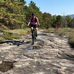
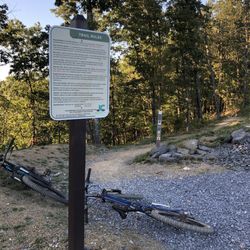
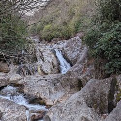
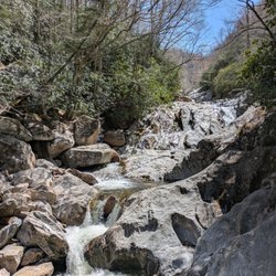
Nice forest preserve not far from downtown Brevard, NC with a little over 9 miles of trails for hiking & mountain biking. There is NO restroom here, so plan accordingly. The parking lot has room for about a dozen vehicles and there are a couple of picnic tables on the side of the parking lot. The steep little road leading up to the park had some pretty big potholes so be careful and go slow. Their website indicates they have 1 campsite there as well so go to the website for more info on that. We spent a couple hours hiking around here and enjoyed the Autumn foliage. The trail is very uneven in many parts with lots of roots and rocks, and a moderate incline in places giving you a little bit more of a workout. read more
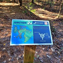
. They have better maps on their website if you're interested. - Hiking Near Me - Brevard, North Carolina")
. They have better maps on their website if you're interested. - Hiking Near Me - Brevard, North Carolina")


More info about Bracken Preserve


Bracken Preserve - hiking - Updated June 2026
Best of Brevard
People found Bracken Preserve by searching for…
Parks in Brevard, North Carolina
Sunrise View in Brevard, North Carolina
Off Road Trails in Brevard, North Carolina
Parks for Picnics in Brevard, North Carolina
Picnic Spots in Brevard, North Carolina
Tent Camping in Brevard, North Carolina
Picnic Areas in Brevard, North Carolina
Playgrounds in Brevard, North Carolina
Secret Spots in Brevard, North Carolina
Things to Do in Brevard, North Carolina
Things to Do at Night in Brevard, North Carolina
Hiking Trails in Brevard, North Carolina
Swimming Lakes in Brevard, North Carolina
Sunrise Hike in Brevard, North Carolina
Scenic Restaurants in Brevard, North Carolina
Dog Friendly Trails in Brevard, North Carolina
Waterfalls in Brevard, North Carolina
Beautiful Views in Brevard, North Carolina
Easy Hikes in Brevard, North Carolina
Walking Trails in Brevard, North Carolina
Running Trails in Brevard, North Carolina
Public Golf Courses in Brevard, North Carolina
Trending Searches in Brevard, NC
Atv Rental near Bracken Preserve
Black Owned Nail Salons near Bracken Preserve
Boat Rental near Bracken Preserve
Cliff Jumping near Bracken Preserve
Day Trips near Bracken Preserve
Dog Friendly Trails near Bracken Preserve
Fishing Spots near Bracken Preserve
Jet Ski Rental near Bracken Preserve
Kayak Rental near Bracken Preserve
Lakes & Ponds near Bracken Preserve
Mountain Biking near Bracken Preserve
Off Road Trails near Bracken Preserve
Outdoor Activities near Bracken Preserve
Picnic Spots near Bracken Preserve
Places To Walk Around near Bracken Preserve
Public Shower near Bracken Preserve
River Swimming near Bracken Preserve
Rock Quarry near Bracken Preserve
Running Trails near Bracken Preserve
Scenic Night View near Bracken Preserve
Scenic Overlook near Bracken Preserve
Secluded Spots near Bracken Preserve
Soccer Store near Bracken Preserve
Splash Pad near Bracken Preserve
Star Gazing near Bracken Preserve
Strawberry Picking near Bracken Preserve
Sunrise View near Bracken Preserve
Swimming Holes near Bracken Preserve
Swimming Lakes near Bracken Preserve
U Pick Farms near Bracken Preserve
Watch Sunset near Bracken Preserve
Water Parks near Bracken Preserve
Browse Nearby
Browse Brands
Related Searches in Brevard, NC
Affordable Bike Repair Services in Brevard, North Carolina
Affordable Bike Tune Up Services in Brevard, North Carolina
Affordable Kayak Rental Services in Brevard, North Carolina
Best Electric Bike Rental Services in Brevard, North Carolina
Best Fishing Locations and Guides in Brevard, North Carolina
Best Places for Horseback Riding in Brevard, North Carolina
Best Sledding Spots and Fun in Brevard, North Carolina
Best Used Bikes for Sale Near Brevard, North Carolina
Best Waterfalls and Swimming Holes in Brevard, North Carolina
Check Out Off Road Trails in Brevard, North Carolina
Discover Dog Friendly Trails to Explore in Brevard, North Carolina
Discover Popular Bike Tours in Brevard, North Carolina
Discover Popular Bike Trails in Brevard, North Carolina
Discover Scenic Mountain Bike Trails Near Brevard, North Carolina
Discover Scenic Waterfall Spots in Brevard, North Carolina
Discover Top State Parks to Visit in Brevard, North Carolina
Discover a Hiking Trail in Brevard, North Carolina
Discover the Best Night Hike Trails in Brevard, North Carolina
Dog-Friendly Hikes With Dogs in Brevard, North Carolina
Enjoy Biking Adventures Around Brevard, North Carolina
Enjoy Camping Adventures Around Brevard, North Carolina
Enjoy Exciting Mountain Biking Adventures in Brevard, North Carolina
Enjoy Hiking Adventures in Brevard, North Carolina
Enjoy Kayaking Adventures in Brevard, North Carolina
Enjoy River Tubing Adventures in Brevard, North Carolina
Enjoy Scenic Night View Experiences in Brevard, North Carolina
Enjoy Tent Camping Spots Around Brevard, North Carolina
Enjoy a Beautiful Waterfall Hike in Brevard, North Carolina
Enjoy the Best Picnic Spots and Ideas in Brevard, North Carolina
Enjoy the Best Tubing Experiences in Brevard, North Carolina
Enjoy the Best Walking Trails in Brevard, North Carolina
Exciting Cliff Jumping Spots in Brevard, North Carolina
Exciting Snow Tubing Experiences in Brevard, North Carolina
Experience Thrilling White Water Rafting in Brevard, North Carolina
Explore Beautiful Parks and Green Spaces in Brevard, North Carolina
Explore Bike Rentals Throughout Brevard, North Carolina
Explore Easy Hikes Perfect for All in Brevard, North Carolina
Explore Electric Bikes Available in Brevard, North Carolina
Explore Fun Activities to Do in Brevard, North Carolina
Explore Nature Spots Around Brevard, North Carolina
Explore Popular Campgrounds Near Brevard, North Carolina
Explore Popular Scenic Overlook Points in Brevard, North Carolina
Explore Scenic Lakes to Visit in Brevard, North Carolina
Explore Secret Spots Worth Visiting in Brevard, North Carolina
Explore the Best Beach Spots in Brevard, North Carolina
Explore the Best Boating Spots in Brevard, North Carolina
Explore the Best Swimming Holes Around Brevard, North Carolina
Explore the Best Trail Options in Brevard, North Carolina
Family Friendly Hiking With Kids in Brevard, North Carolina
Find Parks and Recreation Activities in Brevard, North Carolina
Browse Articles
People who viewed Bracken Preserve also viewed
DuPont State Forest
84 reviews
Rainbow & Turtleback Falls Trailhead - Gorges State Park
3 reviews
The Bike Farm
22 reviews
Merry Falls
1 review
Bent Creek Experimental Forest
11 reviews
Dill and Upper Dill Falls
1 review
Thompson River Waterfalls
2 reviews
Waterrock Knob
26 reviews
Hooker Falls Trailhead - Dupont State Forest
19 reviews
The Paul & Elsie Matthews Overlook
1 review