Fairfield Lake Photos


. - Lakes Near Me - Sapphire, North Carolina")

More like Fairfield Lake
Recommended Reviews - Fairfield Lake
Start your review...

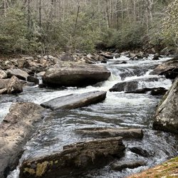
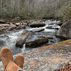
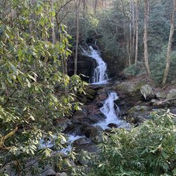
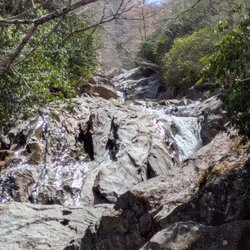
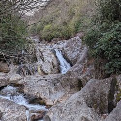
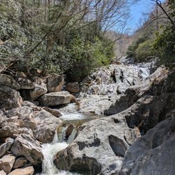
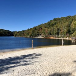
My husband and I are staying (late Sept, 2023) at the Club Wyndham-Sapphire Valley, and we were given a "Sapphire Valley Master Association Amenity Card" for use of amenities while staying on-site. One of the amenities is access to Fairfield Lake, an 80 acre lake at 3,160' elevation in Sapphire, NC. The lake's length is 1 mile, and it is 35' at its deepest point. The amenity card also allows us to use the private beach, picnic tables, a grill, rest room, and to rent motor boats, canoes, kayaks, paddle boards, fishing poles, etc. at the boat house. There is also a Lake Trail around the lake, which is the private property of Camp Merrie-Woode. However, the trail is open to the public (at your own risk) for hiking purposes only during daylight hours from August 15th to May 15th, when camp is not in session. Dogs are allowed but must be on leashes. We saw two brochures, one of which stated that the trail is a 3.3 mile loop while another said that it's 3.8; my Fitbit recorded 3.55 miles. The trail is mostly flat, with an occasional incline or descent, and has a variety of trail surfaces (gravel, pine needles, small rocks, tree limbs, etc.). Besides the lake, there are a few highlights on the trail -- (1) Fairfield Falls. With a height of 25', the waterfall is created by the stream of the Trays Island Creek, a tributary of the Horsepasture River, which runs along the western side of the all Bald directly into Lake Fairfield. (2) Presley Pass. The Iron Bridge across the stream above the waterfall was built by Camp Merrie-Woode caretaker, James Presley, in the mid-1950s. (3) Intersection with the trailhead for the Old Bald Trail, a more strenuous 3 mile hike. The trail is mostly well-marked with small green-white tags. We walked clockwise, and got a bit confused relatively close to our ending point (after a paved road when the signs seemed to disappear). read more


. - Lakes Near Me - Sapphire, North Carolina")


. - Lakes Near Me - Sapphire, North Carolina")

, Sept, 2023. - Lakes Near Me - Sapphire, North Carolina")
. Sept 2023 - Lakes Near Me - Sapphire, North Carolina")
We did the walk while in Sapphire for the week, and it was beautiful! Luckily, the camp was closed, so we are able to do the entire loop around the lake. It ends up being about 3.5 miles from end to end. There are some steep areas, and some areas are challenging to navigate due to the rocks, but it was worth it. There is even a waterfall you pass if you need another reason to check this out. The photos do not do justice to the beauty. read more


9 years ago
Beautiful lake surrounded by mountains. If you are part of the Sapphire Valley Resort/ master association, (requires amenities card), you can rent canoes, kayaks, paddle boards (etc.). There is a small beach and a jumping dock for swimming close by. Fun in the summer for kids/ swimming and great year-round to hike around the lake. read more


9 years ago
More info about Fairfield Lake
127 Cherokee Trl
Sapphire, NC 28774
Directions
(828) 743-1182
Call Now
Visit Website
http://sapphirevalley.com
Hours
Indoor Amenities
Outdoor Amenities


Fairfield Lake - lakes - Updated July 2026
Best of Sapphire
Browse Nearby
BEST of Sapphire, North Carolina Coffee near Fairfield Lake
BEST of Sapphire, North Carolina Things to Do near Fairfield Lake
BEST of Sapphire, North Carolina Hiking near Fairfield Lake
BEST of Sapphire, North Carolina Restaurants near Fairfield Lake
BEST of Sapphire, North Carolina Waterfalls near Fairfield Lake
BEST of Sapphire, North Carolina Breakfast near Fairfield Lake
BEST of Sapphire, North Carolina Resorts near Fairfield Lake
Browse Brands
Browse Articles
People who viewed Fairfield Lake also viewed
Devil's Fork State Park
42 reviews
Caesars Head State Park
44 reviews
Dry Falls
83 reviews
Sliding Rock Falls
52 reviews
Eclectic Sun Rentals at Lake Jocassee
22 reviews
Thompson River Waterfalls
2 reviews
Reedy Branch Falls Trailhead
4 reviews
Southeastern Expeditions
61 reviews
French Broad Falls & Mill Shoals
2 reviews
Merry Falls
1 review