Cancel

    Open app

    Search

    Sassafras Mountain

    4.6 (14 reviews)

    Sassafras Mountain Photos

    Recommended Reviews - Sassafras Mountain

    Your trust is our priority, so businesses can't pay to alter or remove their reviews. Learn more about reviews.
    Yelp app icon
    Browse more easily on the app
    Review Feed Illustration

    Reviews With Photos

    Michelle M.

    It was a nice drive up to Sassafras Mountain with my brother and my niece to see the fall foliage. The roads up to Sassafras are curvy and winding, and is a 48 minute drive from Easley. There was a nice little crowd at the mountain at different areas to look from with beautiful views. Going up to the Sassafras Mountain Tower is a steep walk, and to me was harder to come down than to walk up. Once at the tower the view was beautiful and it was windy and pretty chilly. The trees with their fall coats on and standing with one foot in South Carolina and the other foot in North Carolina was a nice experience. I enjoyed my first visit to Sassafras Mountain, and hope to visit again. A nice fall day to spend time with family.

    Highest point in SC
    Taifha B.

    Sassafras Mountain is technically the highest point in SC, but also straddles the SC/NC state line. If you're looking "to be in two places at once" I couldn't think of a better, more picturesque place to do that. Park in the paved, gravel parking lot. Then walk approximately 1/4 mile to the base of the overlook. There are quiet a few stairs to the overlook, however there is also a ramp. However, by the time you get to the top, it'll all been worth it. The overlook is set up to allow you to see 360 degree views on both the SC and NC sides.

    Sassafras Mountain
    Ruth D.

    Absolutely beautiful views here at the highest point in SC. We loved visiting here and definitely recommend checking out the views. Easy drive and parking was no issue even on a Sunday

    Sassafras Mountain, South Carolina
    Bruce K.

    The highest point in all of the Palmetto State, Sassafras stands tall at 3553 feet. While that's not much of a mountain, it's still pretty tall. Not as tall as the highest point east of the Mississippi which is the nearby Mount Mitchell in North Carolina but certainly taller than the highest points in Florida and Delaware and even North Dakota. Boom, suck it y'all! The mountain is easily accessible by road and just short of the peak is a small parking lot. I was here in January 2019 and there's some construction underway to make a proper observation point at the summit. It looks like it's going to be super awesome but we're not there yet. Great view on a clear day and while today wasn't the clearest, it was still possible to see for a very long way. Love it! [Review 10343 overall, 109 of 2019.]

    NC/SC border
    Johnathan C.

    Beautiful overlook. Great opportunity to visit both Carolinas at the same time. Don't bother going on a foggy day because you won't see anything with a cloud right in your face.

    Diana A.

    Beautiful view! The road was good, although nerve wrecking at some point but all worth it! The look out is well taken care of and a beautiful scenery!

    Two places at once!
    Lane H.

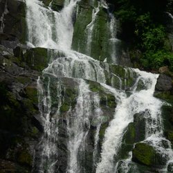
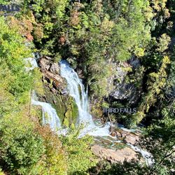
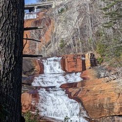
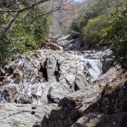
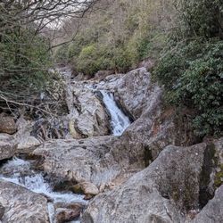
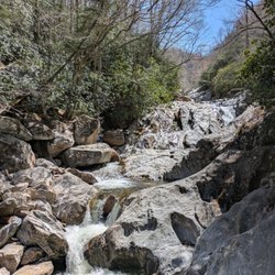
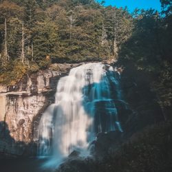
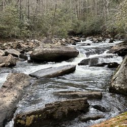
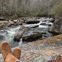
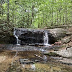
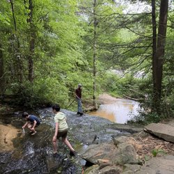
    If you're looking for 360-degree mountain views, go here! On a clear day, you can see into 4 states (SC, NC, GA, and TN) and the observation tower straddles the border of SC and NC so you can actually stand in two states at once. There are several hiking trails nearby, including one that leads to a gorgeous waterfall (Beech Bottom Falls). This is one of the only summits in the US that is ADA-accessible and it is the site of the Eastern Continental Divide.

    Tanna B.

    breathtaking views. Sassafras mountain is the highest mountain in SC. Gorgeous views and a must see.

    Survey Marker

    See all

    4 months ago

    Helpful 1
    Thanks 0
    Love this 1
    Oh no 0

    2 years ago

    Helpful 3
    Thanks 2
    Love this 3
    Oh no 0
    Photo of Sara P.
    0
    13
    21

    1 year ago

    Helpful 0
    Thanks 0
    Love this 0
    Oh no 0

    1 year ago

    Got to cross the border of the Carolina's. We were at the highest point of South Carolina. Long hike tho and there was snakes apparently

    Helpful 0
    Thanks 0
    Love this 0
    Oh no 0

    3 years ago

    Helpful 0
    Thanks 0
    Love this 0
    Oh no 0

    5 years ago

    Helpful 6
    Thanks 0
    Love this 2
    Oh no 0

    3 years ago

    Helpful 2
    Thanks 0
    Love this 2
    Oh no 0

    7 years ago

    Helpful 12
    Thanks 0
    Love this 12
    Oh no 0

    4 years ago

    Helpful 2
    Thanks 0
    Love this 1
    Oh no 0

    2 years ago

    Helpful 0
    Thanks 0
    Love this 0
    Oh no 0
    Photo of Diana A.
    346
    98
    144

    4 years ago

    Helpful 1
    Thanks 0
    Love this 0
    Oh no 0

    5 years ago

    Helpful 1
    Thanks 0
    Love this 1
    Oh no 0
    Photo of Tanna B.
    67
    49
    44

    6 years ago

    Helpful 0
    Thanks 0
    Love this 1
    Oh no 0
    Photo of Richard R.
    4996
    1572
    25885

    13 years ago

    Helpful 36
    Thanks 0
    Love this 32
    Oh no 0

    Ask the Community - Sassafras Mountain

    Review Highlights - Sassafras Mountain

    The trees with their fall coats on and standing with one foot in South Carolina and the other foot in North Carolina was a nice experience.

    Mentioned in 5 reviews

    Read more highlights

    Verify this business for free

    People searched for Hiking 255 times last month within 15 miles of this business.

    Verify this business

    Fourth Falls Trailhead - Fourth Falls

    Fourth Falls Trailhead

    (2 reviews)

    The fourth falls Hike is extremely diffacult but worth it. loved by me and other teen campersread more

    It is important to note FOURTH FALLS is located on the grounds of THE WILDS Christian Camp, which…read moreis private property. You can be granted one day permission to hike the falls via the front office. However, if camp or any special events are in session, permission WILL NOT BE GRANTED, so call prior to making plans to visit: (828) 884-7811 Once you receive acceptable hiking dates, you will go to the walk-up window @ the office next to the General Store. Here they will register you, give clearance and a map of where to go to find the trailhead and falls. There are a total of four falls, but this review will specifically concentrate on the last of the four, aptly named FOURTH FALL. [ THE EXPERIENCE ] The waterfall trailhead is located near the basketball courts. Park and head towards the 2nd bridge just beyond the Giant Swing. There will be a set of water cannon on the bridge railing as a reference. BE SURE TO GET A MAP from the office! But even with it, the trail can be difficult to follow because the map was hard to read. There are also signs directing you to the falls at certain intersections, but we found some intersections were not clearly marked. Best to stay left at many of them. We decided to start at Fourth Falls because we were told the connector trail between 4th and 3rd falls was easier to travel up than down. MORE ON THAT LATER!!! I had my sister who is 58 and not a hiker (except when she comes to visit me from Florida) and her husband with me. Typically I don't take her on hikes I have not been on myself, but it just so happened I had already planned this hike when she asked if it was okay to come for a visit the same week. After successfully navigating to the falls and barely avoiding a copperhead snake along the trail, we hung out on the huge boulder taking pics and enjoying its beauty. Fourth Falls is picture perfect. Even in cold months the beautiful green moss remains draped on its stone ledges. We were told the shortcut route to 3rd falls was steep, but not too bad as long as you are fit. Well, that is a gross understatement, because not only should you be fit, but have good upper body strength AND no fear of heights. SERIOUSLY, this trail is not for the faint of heart! I've hiked to over 100 waterfalls, some on really sketchy trails and I have never been in such fear as I was on this trail. Not so much for myself, but for my sister. We started up the shortcut trail and it really didn't seem too bad. This would easily rate as a Class 3 trail because you have to use both hands and feet. The ease of the first part of it was misleading, because it gets harder & steeper, and then outright Class 4 difficult. [ NO TURNING BACK ] At the point we thought the trail ahead was just too difficult, we realized going back the way we came was probably just as hazardous. So we pressed forward hoping the top of the trail would come into view soon. IT DID NOT!!! My sister was beginning to have a panic attack so I talked her through every step, reassured her I was right behind her if she were to lose her footing. Her breathing got more labored so we stopped whenever it was safe to give her a break and blanket her in constant reassurance, while at the same time pointing out the next safe place to stop uphill. I was feeling very confident I could navigate us through safely until we reached a point where the climb became so steep that two very thick ropes had been tethered to a tree far above and out of view. It was here, at this very spot I began to pray for safety & strength to guide my oldest sister out of this predicament. I was terrified because it was THAT STEEP, but I couldn't let her know I was worried! I then instructed her to NOT lean back while using the ropes and be sure her foot was secure each time before taking another step. I matched her step for step, always remaining within full body contact lest she slip & always wrapping the ropes around my arms in case I had to act as a net if her strength failed. I sent her husband ahead to scout the distance to the top and to see if the trail got any more difficult. We didn't see him for almost 8 minutes. When we did make it to the top and back on level ground, she began to cry. We rested for a while and let her gain her composure before beginning the hike back. I did get a chance to see the other three falls via the wooden staircases at each of them, but she'd had enough adventure for one day and opted to stay on the trail until I returned. [ FINAL THOUGHTS ] Kids do these trails weekly, so you would think hazards would be minimal and without my sister, I probably would not have thought it was as bad. But it truly is THEE ONLY HIKE I've ever regretted not fully researching. Then again, I couldn't because it is on private property and there are very few reviews. Still, Fourth Falls is truly beautiful and can be safely reached on the longer route for the less adventurous! Know your capabilities & ENJOY! 2022 / 30

    Toxaway Falls - Very cool

    Toxaway Falls

    (4 reviews)

    Very cool but a bit hard to find. GPS takes you to the road above. We had to find a better view…read morethrough some unmarked roads. Good luck

    I truly find it unbelievable that I can come into an area and wrack up so many FTR's (first to…read morereview) locations. Am I seriously the only yelper who hikes in North Carolina? I'm even more surprised this particular waterfall had no Yelp page! It has a commanding presence that you absolutely cannot miss AND no hike is required to view it, so you would think SOMEONE would have yelped it by now. TOXAWAY FALLS is a gigantic roadside waterfall downstream of the Toxaway Lake Dam. Nearly the entire waterfall is surrounded by either CRAZY STEEP terrain or private property and the only way to really get a head-on shot of the falls is by drone or helicopter! There is a pull-off east of the bridge that give you a decent side view, but doesn't show the depth of the falls like a frontal view would! You can also visit nearby Toxaway Cafe for lunch and an incredible, but distant side view of the falls. It's the best frontal view you're gonna get unless you happen to rent one of the nearby homes facing the falls. While Toxaway Falls looks more like an enormous water slide, topography maps show the falls begin at around 2,953 feet just below the bridge and the overall terrain drops to an elevation of 2,658 in just under a quarter of a mile for a total decline of 295 feet. The main fall drops 80 feet, from 2,920 feet to 2,840 into a pool of water then continues to cascade over significant drops for the next 1,000 feet (about 3.33 football fields). *** [ THINGS TO KNOW ] Total Hiking Distance: 0 miles (roadside) Difficulty: Easy (viewing platform) Creek Crossings: NO Elevation Gain: 0 feet Waterfall Height: about 90 feet initial drop and over 275 total with cascades. Waterfall source: Toxaway River WATERFALL ATTRACTIVENESS - 7 out of 10 TRAIL ATTRACTIVENESS - n/a Access to top of falls: YES Access to base of falls: NOT REALLY Pool of water @ base of Falls: YES Sitting areas @ base: YES if it were accessible RESTROOM FACILITIES: NO PARKING: YES (space for about 8-10 cars) *** [ FINAL THOUGHTS ] TOXAWAY FALLS is a wonder to behold. MASSIVE in size, but difficult to view in all its glory. Still a worthy stop if you happen to be passing through Hogback, NC on Hwy 64. IF you want to see its true size, click on the link below for a drone video of the falls. ENJOY! Drone video: https://www.youtube.com/watch?v=AW-Bj7jSUv0 2021 / 59

    Purchase Knob - Trail signs

    Purchase Knob

    (2 reviews)

    This has been our favourite walk forever. Do not let the couple of bad characters hinder you from…read morethis beautiful hike, because getting to the top is its own reward with sheer beauty. This property was donated to the state park and open to all. Very clean and well-kept trails, dog friendly, and a nice place to rest and relax, including restrooms at the science centre.

    I discovered this place through my daughter. She has gone here twice- once through her middle…read moreschool, and once through a local camp. She raved about it, and we finally got a chance to check it out. So happy we did! Purchase Knob was generously donated by the McNeil-Gilmore family to Great Smoky Mountains National Park. It is 535 acres of land that rises ultimately to 5,086 feet at the knob. In the meadow below the knob, at 4,850 feet, there are two buildings housing offices, a lab, a classroom for fifty students, and housing for up to eight scientists. Views are 180 degrees. You can hit the Cataloochee Divide Trail here, too. A refurbished cabin originally from the 1870s is nearby, which I will get to in a bit. When you get to the park, you will be blocked by a gate with a sign to the left identifying the park. It is open once in a while for scheduled visits/field trip students. It is easy to get your vehicle locked within the park. (People cannot get locked in.) Park your car on the sides of the road. Just walk around the gate if it is locked. Bring water, and a jacket in the spring or fall. The 2.5 mile round trip trail is basically a wide, dirt road that will eventually lead up to the main buildings. It is well maintained. When you get a glimpse of the building at the top, you will also see a grass trail leading upwards. I would take that trail. It is a shortcut. If you like to walk, just keep going, and the road will eventually lead to the building as well. On the way up, you will see many types of wildflowers. We heard (up) and spotted a hawk (down). I got a photo of nightshade, all the while with my body centimeters from a hidden cliff edge. Be careful on grassy edges! The open areas and tree-filled areas were of equal beauty. In early September I saw purples, greens, grays, and yellows, all framed by a clear blue sky graced by fluffy clouds. Your soul will take this in, and it will hold on to it. When we got to the top, we relaxed. We did not go to the knob proper. We used the very clean bathrooms, and laid down in the field right in front of the buildings. There is a water fountain. You are allowed on the deck, but not in the buildings unless you are with a scheduled group. There are picnic tables grouped close together, and bear-proof trashcans and recycling bins. You can check out the outside of the weather station that is a bit away. I would not traipse around the adjacent fields. I saw tagged plants and left that area so that we would not screw up any data. If you decide to go to the actual knob, you have to blaze your own trail. As of two days ago, the footbridge leading to Cataloochee was out. There is a sign warning of that; be careful crossing creeks. Anyway, that trail is easy to find; just look for signs. Check out the bulletin board for lists of the types of birds and butterflies that you can see there. I saw (possibly) a Cloudless skipper. It was fluorescent yellow! My first. To get down to the restored Ferguson cabin, just leave via the "grass carpet" trail. Make an obvious right and hitch your horse, or kids. This right will lead you to the cabin. The Fergusons were the first farmers to have an elevated farm. Their apples are still there. Do not pick anything. Do not get in the boar trap. Do not get near bears. Do not bother the cow spirits. Call to make sure horses are indeed still allowed. Bears and boars can hurt you. We leave all snacks in the car. You never know. Call the general number to see if bear activity is intense before going to this park. Middle school and up teachers, call this number to schedule a visit: 828-926-6251. This park welcomes wimpy and tough hikers mid-March through November. Call if you have a desire to hike in the deep winter. Remember to check out the Purchase Knob WebCam online for weather and views. To get to this park, take Exit 20, stay on 276 South for five miles. Get on Hemphill Road and stay on Hemphill Road for four miles. This review is dedicated to my daughter Sophie, a quick, beautiful trailblazer.

    Thompson River Waterfalls

    Thompson River Waterfalls

    (2 reviews)

    IF you want a challenging hike and are looking to score a bunch of amazing waterfalls on the SAME…read moreTRAIL, the Thompson River Waterfalls trail is your Huckleberry!!! Google maps has labeled the trailhead HIGH FALLS TRAIL HEAD just off Whitewater Road. As you turn onto Brewer Road, you will see a wide trail entrance on the corner. We parked along the side of the road near the entrance. There are multiple waterfalls along the trail as Thompson River makes its run down the mountain, dropping approx. 1,900 feet over 5 miles as it makes is way to beautiful Lake Jocassee. There are seven names waterfalls along the trail and 3 that absolutely should not be missed: HIGH FALLS, RICH FALLS & BIG FALLS aka THOMPSON FALLS. THE TRAIL The trail initially ascends about 60 feet but remains at a fairly consistent decline of about 500 feet along the entirety of the main trail. First up was REID FALLS at around .9 miles, but we decided to skip it. A split in the trail at around 1.1 miles leads to HIGH FALLS, a gorgeous 50 foot sliding ribbon waterfall. There really is no way to get an excellent picture of the falls without getting wet. The best vantage of the falls is across the river and a scramble over some large boulders to a beach like area. The pool in front of the falls is better than 6 feet deep, but most of the shallow areas were only ankle or calf deep. Back along the main trail we continued our descent down the mountain and next came to SIMON FALLS, which we also opted to skip. All of the falls (except High Falls) require a scramble downhill to view. Reid and Simon Falls have the least steep scrambles, but we wanted to conserve our legs for Big Falls, the steepest of the scrambles. We also bypassed Rich Falls around the 3.8 mile mark as we decided it would be best to see how we feel after tackling Big Falls. BIG FALLS Listen, however easy the trail seemed up until this point was about to SEVERELY change! The descent to the falls is about 535 feet in less that a quarter of a mile. IT IS VERY STEEP and some areas require sitting on your butt and sliding, other require holding on to low branches or roots and one area in particular requires mild vertical rock climbing. NOT KIDDING! But all of it is doable if you take your time and don't have any serious physical or health challenges. All of the MAIN trail is very easy to follow, but I would highly recommend downloading the ALLTRAILS map because it shows the exact entry points for the side trails to each of the falls. The side trail to Big Falls is easy to follow, but can be very faint in some areas. Once you make it down to the river, look for a side trail just before the final descent to the riverbank. It will lead you through a thicket of vegetation that leads to a boulder entrance to the falls. Navigate them as best you can to get to a great vantage point to view the falls. If you are not skilled at boulder hopping, this area will be very intimidating! But you MUST do it in order to view the Big Falls, which is not visible otherwise. NOTES / TIPS ~ Download ALLTRAILS MAP prior to your drive to the trailhead ~ There are 3 river crossings and yes you will get wet ~ Most of the falls require getting wet for best view ~ No restroom facilities at the trailhead ~ BRING PLENTY OF WATER & SNACKS FINAL THOUGHTS On our return, we were just too exhausted to attempt to see Rich Falls, so instead we used every ounce of energy we had remaining to make it back to the car. I was thoroughly exhausted. The 3.5 miles back seemed more like 10 and we'd run out of drinking water during our time at Big Falls. I recommend a minimum of five 16oz bottles to do this hike and more if you bring salty snacks. I'd also recommend you chug one bottle at the parking area before you begin. All in all this is an amazing trail full of gorgeous waterfalls. Big Falls easily has become one of my top 5 favorite southern waterfalls... but it is a beast of a hike! ALLTRAILS LINK: https://www.alltrails.com/explore/trail/us/north-carolina/thompson-river-waterfalls?mobileMap=false&ref=sidebar-static-map 2023 / 12

    A series of gorgeous waterfalls along beautiful Thompson River as it makes its way from the higher…read moremountain elevations down to the Jocassee River. The trail offers a great experience for anyone at any hiking level. If you are like me and prefer more leisurely hikes, The first three waterfalls (Reid Branch, High Falls & Simon Falls) are fairly easy to reach. High Falls in particular is great for families with small children and has a wading pool of water at its base of different depths. There is even a small beach like area to relax and have a picnic. Just know you must get wet in order to reach the beach area, which also has the best view of the falls since High Falls kind of sits recessed into a little nook making it difficult to see in its entirety. But for those who are more like my husband and don't mind a more difficult hike, Rich Falls and Big Falls further downstream will give you plenty of challenge. Although I must say, my husband was sore several days after his hike and while he thought Big Falls was stunning, he was miserable on the return. He said the side trail to Big Falls was extremely steep and challenging, both on the way down and especially on the climb back out. It drained him completely at age 54 and he still had to endure a 3.5 mile hike back to the car running on empty. Knowing him he'll do it again! MEN... LOL Also near the parking area is a trail leading to White Owl Falls. A very short hike to a beautiful 20 foot waterfall. Walk west on Whitewater Road from the parking area and look for an opening with a pink ribbon tied to a tree branch about 900 feet from the trailhead.

    Connestee Falls

    Connestee Falls

    (7 reviews)

    This was a surprise for me that there was a sweet little waterfall so close to my sister's new…read morehometown. It's located in a park, yet there's no where to picnic. It's just the falls, unless I missed some hidden walking trails. Nonetheless, the falls are calming, and not at all congested like Looking Glass Falls in Pisgah National Park.

    Undoubtedly a beautiful & scenic location as two creeks (Carson Creek and Batson Creek) separately…read morefall into one of North Carolina's mini-gorges to form a third waterfall known as "the silver slip". The formation of the falls collectively is a "Y-shape" as Connestee Falls meets Batson Creek Falls to form Silver Slip Falls. It is one of the most unique waterfalls I've ever come across and would be much better photographed with a drone. There is an overlook on the Batson Creek side that faces Carson Creek, however, it is only accessible from a private trail in nearby Connestee Falls Subdivision. Thusly, the best view you will get as a non-resident will be from this nicely constructed boardwalk. The boardwalk hangs over Connestee Falls, so your view is very limited. Batson Creek Falls is visible, but not in its entirety as trees block most of the upper half of this nearly 100 foot tall sliding beauty. Topography maps show the elevation around Connestee Falls dropping roughly 65 feet before merging with Batson Creek Falls. Sliver Slip Falls is nearly impossible to see with the exception of the crest. [ FINAL THOUGHTS ] A staff member from our hotel told me about this waterfall and I'm so happy he did. It was our very last stop on a waterfall chasing weekend that included Upper White Water Falls, Toxaway Falls, Gorges State Park, Looking Glass Falls & Skinny Dip Falls. While it isn't a destination waterfall and rather difficult to properly view, it most certainly is a nice add-on when touring the area. 2021 / 67

    Wildcat Branch Falls - View of one of the falls in the hike (you cross stones as part of the trail).

    Wildcat Branch Falls

    (15 reviews)

    There are a variety of places to hike around the area. This would be the short hike with bang for…read moreyour buck. I made a loop in 45 minutes or so from the parking area with what is apparently an established food stand. There isn't a lot of space between the parking area and the side of the highway, so be ready. The scenery revolves around several waterfalls, the highest of which surprised me with its size. There is an excellent variety of terrain for a short scamper, and while it is an incline, people with milder mobility limitations could still reasonably expect to get to the falls in time. There is no charge to enter, and plenty of reason to make the falls part of your day.

    Family hike #9; yay! Hubby and the boys hiked this trail back in October 2024 while we were…read morecamping, but I decided not to join, because my then nearly 2-year-old toddler was a sprinter (still is) and I didn't trust to take her on this journey. Didn't take her with us this time either; haha. Anyway, they were nice enough to agree to return to Wildcat Wayside with me. 3 waterfalls for the price of 1, except there is no price, because it's free! The hike was lush with foliage and a lot of the rhododendron blossoms had already fallen on the trail; I never knew they were so pretty. Saw lots of snails on leaves, millipedes, mushrooms; it was fantastic finding living treasures! Upper Wildcat Branch Falls was a slight disappointment to me as I expected more of a rush of water since it rained quite a bit the couple of days before, but it's height is still impressive. My boys also found salamanders and even a tiny baby axolotl in the water! I was blown away. To me the hiking trail was easy even with the stairs. I think I finally have built up a tolerance, because my legs no longer hurt after hikes I go on. It's only about a mile long, so it's not too bad, but there is elevation change and people who aren't used to it may find it somewhat challenging depending on stamina. I wonder if Pauly's Gourmet Peanuts Truck still comes around on the weekends, because it wasn't there on a Wednesday; would've liked to check it out. The trail was somewhat busy with hikers, but definitely not overrun. The weather was perfect for hiking, but it was cooler than expected. I should have been brave and joined the polar bear club with cold immersion in the swimming hole at Lower WBF, but alas; hopefully next time. No bathroom facilities are available here, so go before you come. On to hike #10! Happy yelping!

    Sassafras Mountain - hiking - Updated May 2026

    Loading...
    Loading...
    Loading...