1. South Cove County Park

0

Seneca, SC

Cancel

Open app

Search

South Cove County Park

3.4 (9 reviews)
Closed • 7:00 am - 10:00 pm

South Cove County Park Photos

More like South Cove County Park

Recommended Reviews - South Cove County Park

Your trust is our priority, so businesses can't pay to alter or remove their reviews. Learn more about reviews.
Yelp app icon
Browse more easily on the app
Review Feed Illustration

3 months ago

Helpful 0
Thanks 0
Love this 0
Oh no 0

1 year ago

Helpful 0
Thanks 0
Love this 0
Oh no 0

6 months ago

Helpful 0
Thanks 0
Love this 0
Oh no 0
Photo of Kat S.
248
184
189

2 years ago

Helpful 14
Thanks 4
Love this 7
Oh no 0

2 years ago

Helpful 0
Thanks 0
Love this 0
Oh no 1
Photo of Abby D.
331
24
14

9 years ago

Helpful 0
Thanks 0
Love this 1
Oh no 0

10 years ago

Helpful 1
Thanks 0
Love this 1
Oh no 1
Photo of Bill Y.
0
609
252

11 years ago

Helpful 1
Thanks 0
Love this 2
Oh no 0

7 years ago

Helpful 0
Thanks 0
Love this 0
Oh no 0

Ask the Community - South Cove County Park

Verify this business for free

People searched for Parks 224 times last month within 15 miles of this business.

Verify this business

Riley Moore Falls

Riley Moore Falls

5.0(4 reviews)
12.3 mi

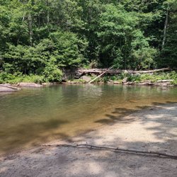
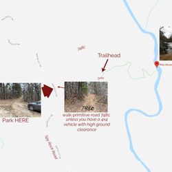
I just wanted to update my 3/15/20 review below to add I've now done this hike several times, but…read moreTHIS time I had the chance to hike it with a friend who is directly related to the namesake of the waterfall... Riley Moore. Sandie is a church friend of mine and Riley Moore was her Great Great Uncle (I believe that's right). He once upon a time operated a grist mill here at the top of the falls. She's been trying to get here to see the waterfall, but couldn't find it and wanted to join us (along with her family) since I knew the way. Upon further research I discovered there are actually still remnants of the mill including visible drill holes, spikes and bolts. Thought that was pretty cool info to share! [ [ [ PREVIOUS REVIEW ] ] ] Riley Moore Falls is small in height but HUGE in personality. It's located off State Road S37-748, which is a nicely maintained gravel road where cars and trucks alike can comfortably traverse. ~~~ DIRECTIONS From Westminster, SC - DO NOT turn onto Cobb Bridge Road from Long Creek Hwy (Hwy 76) where you will see the brown & white sign pointing you in the direction of Riley Moore Falls. Our GPS had us go this way, then left onto State Road S37-748, but the road was CLOSED during our visit! INSTEAD, turn onto PU-32 also known as Rocky Fork Road. Turn left onto a gravel road near Rocky Fork Baptist Church and follow that until it dead ends @ State Road S37-748 (also known as Spy Rock Road). Turn right and drive approx. 1.4 miles (4 minutes) to 748c (aka Riley Moore Shoals Road). Park at the intersection of State Road S37-748 and 748c. DO NOT ATTEMPT TO DRIVE 748c in a car or minivan. Low clearance vehicles will find the terrain on this road to be VERY difficult to navigate without bottoming out or getting stuck. I'd also recommend 4x4 capability on wet days! There can be several deep-pocketed muddy areas after heavy rains. ~~~ THE TRAIL Once you reach the intersection of Spy Rock Rd (S37-748) and 748c, park roadside on Spy Rock, secure your vehicle and begin your hike approx. 1/2 mile down the "primitive road." IF you have a high ground clearance SUV or truck, you can drive the primitive road another half mile or so to a second parking area near the trailhead. The primitive road is VERY BUMPY  and can be muddy in spots after heavy rains, so a 4x4 is best. After reaching the second parking area, follow the marked trail on the left!!! The trail is a little over a 1/2 mile to the falls from here. The trail is fairly straightforward and easy to follow. ~~~ THE FALLS Once you reach the Chauga River, you will notice a large sandy area with plenty of room for an entire horde of hikers!!! Riley Moore Falls is not very tall (only about 12 feet), but it is very wide and has a deep base pool. PRO TIP - Bring swimwear, towels and a picnic, but be sure to pack it in and pack it out. ~~~ THINGS TO KNOW Hiking Distance: 2 miles (round trip to falls from S37-748) Difficulty of hiking 748c: All downhill to trailhead (moderate return) Difficulty of hiking trail to falls: EASY Creek Crossings: NO Elevation Gain: 357 feet Waterfall Height: Approx 12 feet Access to top of falls: NO - not without getting wet Access to base of falls: YES Pool of water @ base of Falls: YES Sitting areas @ base: YES + sandy beach RESTROOMS: NO PARKING: YES (along road) + secondary parking area closer to trailhead for trucks and high ground clearance vehicles with room for about 6 cars. ~~~ [ FINAL THOUGHTS ] A lovely waterfall in any season, but also a great spot for a summer swim. While we had the waterfall practically to ourselves during our Mid-March expedition, be advised other trail website reviews say it gets trashy & crowded in summer months. What a shame if that is true because it truly is a treasure. ENJOY! 2022 / 74 #UPDATE 178

This is the best waterfall we got to visit in SC this far. After we left Reedy Branch Falls we…read moredrove here. Well, as close as we could get. I didn't realize that we couldn't drive all the way to the trailhead so we had a long hike in store due to me having to carry my toddler most of the time. I should have re-read the previous reviews before coming. My friend did help me carry her as well and for that I was very thankful. So definitely don't recommend this hike with a little one unless strapped in a carrier. Also, I don't recommend it for the elderly either. It's definitely a wilderness hike deal with roots and elevation change. In fact, it's mostly downhill on the way to the falls, but on the way back it's pretty much all uphill, which was not fun with aforementioned young child. It's about a half mile to the actual trailhead and then another 0.7 mile to the falls. That's about 2.4 miles round trip. The reason of course that my boys absolutely became enamored with this place is the large swimming hole. It is wonderful and has plenty of space. The waterfall itself is beautiful and although it's not as tall as others, its width is quite impressive. I was trying to get as close as I could and even noticed a hidden part of the falls inside of the rock structure. That was so cool!! The sand at the base and shore give it a beachy vibe. We definitely packed it in and out making sure not to leave anything behind as to preserve the area as best as possible. Needless to say we were wiped by the time we made it back to our vehicles, but we're still glad we decided to venture here. Coming back with my hubby and boys in the very near future. Happy yelping!

Photos
Riley Moore Falls
Riley Moore Falls - CREATED FROM GOOGLE MAPS

CREATED FROM GOOGLE MAPS

Riley Moore Falls

See all

High Falls County Park

High Falls County Park

3.0(7 reviews)
6.1 mi

My husband and I went camping in our RV here years ago. We came back for several nights, as we…read morelove the area. Unfortunately, and to no one's fault it rained the whole time we were there. We did take a local jaunt out on a drier afternoon, but the next day we were leaving. This is a beautiful park with many spacious sites. We did enjoy our stay here, but wished we had better weather. A picnic table and fire pit were available for our use. I forgot if it had a BBQ grill, but we had our own. We had electric and water hook up. We'll be back again.

Great overnight camping! Fire rings, picnic tables, and roomy, flat campsites for both trailer, RV,…read moreand tent camping. The bath houses are always clean, they have 2 different camp hosts, who are both very helpful and keep the campsites at a clean, topnotch level. There is a boat launch, 2 different playgrounds, basketball courts, tennis courts, pickle ball, horseshoes, volleyball sand area, and kayak rentals with various sizes of life jackets available. They also have a sandy beach area and are dog friendly! There is a camp store and Snack Shack(but they haven't been open since we've been here, April/May). But we played giant checkers on the store porch. It has a wonderful view of the lake with nice rocking chairs to relax in. There are also picnic areas for day use for a small entry fee. Overall, it was a great place to stay with family and friends.

Photos
High Falls County Park
High Falls County Park - Very nice restrooms, showers, drink machines, volleyball, basketball and tennis courts all beside the swimming area.

Very nice restrooms, showers, drink machines, volleyball, basketball and tennis courts all beside the swimming area.

High Falls County Park

See all

South Carolina Botanical Garden

South Carolina Botanical Garden

4.4(39 reviews)
8.6 mi

Ever so many directions to wander to experience a botanical wonderland representing flora from…read moreSouth Carolina's coastal region to the high hill Piedmont area. The best part of it all is when you find personally enamored rare plants, native or exotic, many appear annually at the SCBG Fall & Spring plant sales.

Tucked away off the campus of Clemson on a vast plot of land is the South Carolina Botanical…read moreGardens. Like some other college-affiliated gardens, this one is free of charge to all visitors. It's a bit tough to get your bearings at first since the property is really spread out, and requires quite a bit of driving to get from place to place, where first time visitors (like me) are sure to get lost along the way, even with a map of the property. I recommend starting your visit with the visitors center, carriage house, and geology museum, which are adjacent to the desert and Jurassic gardens. I tried to get intel on best places to see blooms at the visitors center, but staff weren't overly helpful in assisting where to explore, so I basically grabbed the map and drove off meandering around the back roads, winding up at the Hanover House (super friendly staff here) and the Caboose and President's gardens (some blooms in this area). Despite feeling a bit lost while exploring and encountering very few blooms, I did overall enjoy my visit to the South Carolina Botanical Gardens. I would rate it as a 3.5 out of 5 experience overall, as much of the land on property seemed not to serve much of a purpose, and you really have to spend time exploring (and getting lost) to find interesting blooms.

Photos
South Carolina Botanical Garden
South Carolina Botanical Garden - Side

See all

Side

Sunset Rock - Sunset Rock trail - views from the sunrise side at 4:45pm

Sunset Rock

4.0(6 reviews)
26.3 mi

In less than 2 months I leave for my first ever missions trip to the continent of Africa. I…read morerecently experienced a mission trip to Haiti this past July (as detailed in my 410 Bridge review) and I was asked to join the Kenya team shortly after. I've had a great deal of time to reflect on that trip, because it honestly didn't meet my expectations. So this time I've decided to begin preparing myself mentally & spiritually well in advance of departing. I want this trip to be ALL that God intends for it to be and I don't want any of ME in the way. I purposely plan to use my time these coming weeks reflecting on all aspects of life. Daily areas where I miss simple truths that could teach me small valuable lessons. I know this may sound corny to some, but I would feel irresponsible if I didn't begin building my mental strength now, knowing that my last trip was probably not as fruitful as it could have been had I done the same prior. So, until I depart for my "big trip" I wanted to take the opportunity to use some of my reviews to reflect on the experience of places I visit. A mental way for me to decompress and prepare. First up, Sunset Rock. --- THE SCENE It was my first visit to Highlands, North Carolina. Admittedly I drove through the town a few years prior as my wife and I took a long detour home from a weekend in Asheville, but we paid little to no attention to the charm of this tiny mountain hamlet. I'd completed my mission of visiting nearby Dry Falls and Bridal Veil Falls, so my only goal at the time was dinner @ the Dillard House before hitting the road for our final 2 hour leg home. It could have been an amazing parade going on in the middle of town and it would not have deterred me from my plans. * REFLECTION - What is is about some of us that completing the goal is more important than experiencing the journey? I think in my life, and especially in my last mission trip, my desire to complete certain goals often outweighs the journey that I was sent to be on. During my visit to Highlands THIS time, I had no plans to actually walk around the city. There was a mountain I wanted to climb, a shadow in a valley I wanted to experience, a covered bridge I needed to photograph and a waterfall I missed on my last pass through town. I can be very scheduled and regimented, especially when it comes to travel because I don't know when/if I will be back that way again. So as I drove through this beautiful village, the thought occurred to me to slow down and enjoy the journey. I decided to park my car and walk. I had several wonderful conversations with locals. One lead me to an amazing burger at a local grocery store. While I was sitting enjoying my burger, another conversation lead me to Sunset Rock. I honestly didn't have time to visit, but what really peak my interest was the fact it seems to be more of a local secret than common visitor knowledge. So, instead of hiking to the waterfall I originally planned to visit, I drove directly here. --- THE EXPERIENCE I was told by locals I could take my car up the gravel driveway to the top, and apparently others were told the same as there were three other cars at the top. However, after returning home I discovered several sites saying the trail is meant to be for hiking only. One site mentioned signage at the beginning of the driveway, but was so focused on the goal that IF there was signage saying don't drive, I didn't notice. I called local authorities and it is indeed okay to drive to the top, but in retrospect I wouldn't advise it. The road is EXTREMELY narrow most of the way up and there is no room for error! Also, hikers have to really hug the roadside to allow you to pass as you kick up gravel dust in your wake. I'm sure that can be uncomfortable and unnerving, especially for those with small animals and children. * REFLECTION - Others truths are not always your reality. Even when something is okay, it's not always advisable. At the top is a small gravel turn around where I parked. A small stone with 'Ravenel Park' sits off to the right. Take the short trail near the information board. As you walk, an opening in the trees comes into view. Once you reach the granite outcrop and begin up the slight incline, the glory of sunset rock unfolds! The granite surface, although extremely bumpy and other worldly, is expansive and open like a stone dome. It is said to be thee spot you want to experience a sunset in the Highlands and I believe it! Hopefully my next visit will give me opportunity to experience it with my wife and kids. --- FINAL THOUGHTS Undoubtedly a gorgeous hidden gem! Yes, you are allowed to drive to the top, but honestly it is a short hike and the trail barely has room enough for one car, let alone if two cars are passing. My advice - enjoy the journey and walk. The hike is short and the view is sweet, plus the exercise is good for you! What more could you ask for :-) 2016/122

Dangerous road to the top of Sunset Rock by vehicle but only a ten minute walking hike with a few…read morespaces to the right of the road to park your car. Single lane dirt road with huge wet rocks blocking the way up and we got stuck mid-way. Met some hikers on the road and chatted briefly. No bears found but hikers be on the lookout. Sunset Rock is also known as Ravenel Park. I DO NOT RECOMMEND DRIVING ON THIS ROAD...EVER.

Photos
Sunset Rock - Sunset Rock - views from the sunset side (around 4:45pm)

Sunset Rock - views from the sunset side (around 4:45pm)

Sunset Rock - Instagram: @telephonesmoothie

Instagram: @telephonesmoothie

Sunset Rock - Instagram: @telephonesmoothie

See all

Instagram: @telephonesmoothie

South Cove County Park - parks - Updated October 2026
Loading...
Loading...
Loading...