Oconee State Park Photos


You might also consider
More like Oconee State Park
Recommended Reviews - Oconee State Park
Start your review...

Reviews With Photos

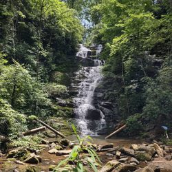
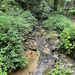
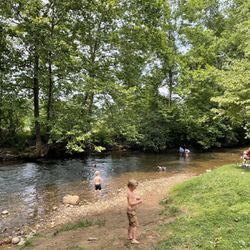
Park was very clean, staff was extremely friendly and helpful. Park has a lot of RV sites, cabins and primitive campsites. Large lake for fishing or you can rent paddle boats. A lot of trails to hike as well as the trail head for the 77 mile Foothills trail. Park store for your basic needs if you forget something, playground for kids. WiFi is available, but who needs WiFi when enjoying nature! Well worth the visit.

3 months ago
My boys and I had a wonderful 2 night, 3 day stay in Cabin 4. Check in was smooth! The cabin had two bedrooms, a living room area with a table/seating, one bathroom with shower and a kitchen. The kitchen has a microwave, large fridge, keurig with pod dispenser or brewed coffee. There are four plates, four bowls and silverware for four people. We opted to bring plasticware for ease and use paper plates. We also brought a pizza cutter, which I'm glad we did. We were supplied with two rolls of TP and a towel/washcloth for up to four people. There are cooking utensils in drawers and a holder by stove. However the utensils in the holder by the stove had sugar ants. I didn't encounter any other big issues in the cabin, but you're in the woods...I was surprised we didn't see more. Cabin 4 has a beautiful sitting area with Adirondack chairs and a fire pit which made for relaxing evenings. The cabin is located right on the lake and we were able to set up for fishing and hang a hammock easily. My only complaint is that the cabin is supposed to come with a kayak, at no charge. We were told the kayaks had not arrived. In this situation it would have been nice to be given the option to use one at the store for no charge. This was not offered not did they allow. If we are not receiving all the items as listed then a discount or alternative option should be provided to guests. The pedal boats are $10/hr. On the site it said must be 16 to ride solo, however when renting we were told anyone in the boat had to be 16+. Another bit of information that should be corrected on their site. Luckily we made it work and they were accommodating. The store has ice cream, snacks, drinks and Knick knacks. Even firewood if you forget yours. All in all, it was a beautiful time and we made great memories! read more


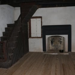
My wife booked a cabin on the lake for our anniversary at Oconee State Park. We were quite surprised at how nice the cabin was considering it's a state park. It was well maintained and had newish appliances and plenty of cookware, cutlery and other essentials but we had brought our own anyway. Cabin #4, built in 1935 by the Civilian Conservation Corps, has a back patio area with two Adirondack chairs, fire pit, and a charcoal grill. The grill is sufficient but next time I'd bring a kettle grill. The park has several hiking trails which seemed to be fairly easy. Unfortunately, we didn't go hiking because my wife broke her arm prior to us getting there. They also offer kayak, canoe, and pedal boat rentals. Overall we had a good time. read more


2 years ago
Park was very clean, staff was extremely friendly and helpful. Park has a lot of RV sites, cabins and primitive campsites. Large lake for fishing or you can rent paddle boats. A lot of trails to hike as well as the trail head for the 77 mile Foothills trail. Park store for your basic needs if you forget something, playground for kids. WiFi is available, but who needs WiFi when enjoying nature! Well worth the visit. read more


2 years ago
5 years ago
Stayed the weekend at site 36 next to the lake. Check in was a breeze and the store is one of the biggest I've seen yet in. State park. Staff is friendly. They are currently making improvements to one half of the camp sites. Bathhouse facilities are newly remodeled looking. There is plenty to see and do in and out of the park. read more


4 years ago
7 years ago
13 years ago
5 years ago
8 years ago
12 years ago
More info about Oconee State Park
624 State Park Rd Dept A
Mountain Rest, SC 29664
Directions
(864) 638-5353
Call Now
Visit Website
http://www.southcarolinaparks.com/oconee/introduction.aspx
Hours
Indoor Amenities
Outdoor Amenities
Other Amenities
Ask the Community - Oconee State Park
Review Highlights - Oconee State Park


Oconee State Park - parks - Updated June 2026
Best of Mountain Rest
People found Oconee State Park by searching for…
Fishing in Mountain Rest, South Carolina
Dog Parks in Mountain Rest, South Carolina
Swimming Holes in Mountain Rest, South Carolina
Playgrounds in Mountain Rest, South Carolina
Watch Sunset in Mountain Rest, South Carolina
State Parks Camping in Mountain Rest, South Carolina
Fishing Lake in Mountain Rest, South Carolina
Things to Do in Mountain Rest, South Carolina
Boat Rental in Mountain Rest, South Carolina
Dog Friendly Trails in Mountain Rest, South Carolina
Scenic Overlook in Mountain Rest, South Carolina
Kayak Rental in Mountain Rest, South Carolina
Swimming Lakes in Mountain Rest, South Carolina
Fishing Spots in Mountain Rest, South Carolina
Walking Trails in Mountain Rest, South Carolina
Places to Swim in Mountain Rest, South Carolina
Marinas in Mountain Rest, South Carolina
Off Road Trails in Mountain Rest, South Carolina
Parks for Picnics in Mountain Rest, South Carolina
Kids Playground in Mountain Rest, South Carolina
Tent Camping in Mountain Rest, South Carolina
Sunset View in Mountain Rest, South Carolina
Browse Nearby
Browse Brands
Related Cost Guides
Browse Articles
People who viewed Oconee State Park also viewed
High Falls County Park
7 reviews
Devil's Fork State Park
41 reviews
South Cove County Park
8 reviews
Crooked Creek Rv Park
7 reviews
Old Corundum Millsite Campground
1 review
Highlands Hidden Creek RV Resort
6 reviews
River Falls At the Gorge
32 reviews
Endless Adventures Lake Keowee Jet Ski Rentals
9 reviews
Brasstown Falls
4 reviews
Lee Falls Trailhead
2 reviews