Tesnatee Gap Lookout Point Photos


More like Tesnatee Gap Lookout Point
Recommended Reviews - Tesnatee Gap Lookout Point
Start your review...

The Tesnatee Gap parking area has space for about 15-plus cars off Hwy 348 which is also known as the Richard Russell Scenic Highway that's approximately 12 miles northwest of Helen, 15 miles southeast of Blairsville. Tesnatee Gap Lookout Point offers visitors a serene and picturesque setting to enjoy the natural beauty of mother nature and also provides access to the AT. With stunning views and peaceful surroundings, this lookout point provides a perfect spot for relaxation and reflection, it's definitely worth spending a few minutes of your time while driving through the area. read more


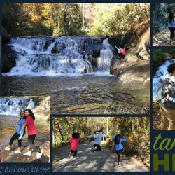
On our way from Helen to the Wolf Mountain Vineyards, we took the backroads including some of the curvy twisty roads known as the Richard B. Russell Scenic Highway. Along the road a number of parking areas with lookouts but none were as fabulous as this one which is near the Tesnatee Gap. The drive is amazing in a fancy sports car and if you're a motorcycler, just as incredible. Here at the gap - some 3000 feet ASL according to the GPS - it was absolutely stunning and about what I expected to see. Come back in a week or two and you'll have the leaves changing. This is not the highest point in Georgia. That would be Brasstown Bald and it's about 15 miles north of here and we did not have time to visit. I guess because of boredom, the kids have spray painted graffiti and tags on the parking lot ground. Thankfully, they haven't damaged the amazing view. As for the turd in the big white pickup truck that decided to blast us with his horn... I hope you hit a tree. [Review 15947 overall - 445 in Georgia - 1452 of 2021.] read more
More info about Tesnatee Gap Lookout Point
6931 Richard B Russell Scenic Hwy
Cleveland, GA 30528
Directions
Hours
Outdoor Amenities


Tesnatee Gap Lookout Point - parks - Updated May 2026
Best of Cleveland
People found Tesnatee Gap Lookout Point by searching for…
Scenic Overlook in Cleveland, GA
Lookout Points in Cleveland, GA
Running Trails in Cleveland, GA
Stroller Friendly Hikes in Cleveland, GA
Beautiful Views in Cleveland, GA
Walking Trails in Cleveland, GA
Running Tracks Open to the Public in Cleveland, GA
Places to Take Pictures in Cleveland, GA
Fun Things to Do With Kids in Cleveland, GA
Scenic Places in Cleveland, GA
Trending Searches in Cleveland, GA
Baseball Fields near Tesnatee Gap Lookout Point
Boat Rental near Tesnatee Gap Lookout Point
Botanical Gardens near Tesnatee Gap Lookout Point
Bounce House Rentals near Tesnatee Gap Lookout Point
Campgrounds near Tesnatee Gap Lookout Point
Cliff Jumping near Tesnatee Gap Lookout Point
Fishing Spots near Tesnatee Gap Lookout Point
Flower Shop near Tesnatee Gap Lookout Point
Garage Sales near Tesnatee Gap Lookout Point
Garden Center near Tesnatee Gap Lookout Point
Hair near Tesnatee Gap Lookout Point
Nurseries & Gardening near Tesnatee Gap Lookout Point
Outdoor Activities near Tesnatee Gap Lookout Point
Outdoor Furniture Stores near Tesnatee Gap Lookout Point
Party Equipment Rentals near Tesnatee Gap Lookout Point
Pedicure near Tesnatee Gap Lookout Point
Pick Your Own Farms near Tesnatee Gap Lookout Point
Picnic Areas near Tesnatee Gap Lookout Point
Places To Take Pictures near Tesnatee Gap Lookout Point
Public Running Track near Tesnatee Gap Lookout Point
Rock Quarry near Tesnatee Gap Lookout Point
Scenic Drive near Tesnatee Gap Lookout Point
Splash Pad near Tesnatee Gap Lookout Point
Strawberry Picking near Tesnatee Gap Lookout Point
Swimming Holes near Tesnatee Gap Lookout Point
Browse Articles
Browse Nearby
Browse Brands
Related Searches in Cleveland, GA
Best Nature Trails for Hiking in Cleveland, Georgia
Discover Baseball Fields Around Cleveland, Georgia
Discover Fun Activities to Do in Cleveland, Georgia
Discover Lakes & Ponds to Explore in Cleveland, Georgia
Discover Popular Photo Spots in Cleveland, Georgia
Discover Top Nature Parks to Visit in Cleveland, Georgia
Discover Top State Parks to Visit in Cleveland, Georgia
Discover the Best Beaches in Cleveland, Georgia
Enjoy the Best Family Activities in Cleveland, Georgia
Enjoy the Best Picnic Spots and Ideas in Cleveland, Georgia
Enjoy the Best Walking Trails in Cleveland, Georgia
Explore Beautiful Botanical Gardens in Cleveland, Georgia
Explore Easy Hikes Perfect for All in Cleveland, Georgia
Explore Family-Friendly Zoos and Wildlife in Cleveland, Georgia
Explore Free Picnic Areas Around Cleveland, Georgia
Explore Fun Activities to Do in Cleveland, Georgia
Explore Landmarks & Historical Buildings in Cleveland, Georgia
Explore Parks With Pull Up Bars in Cleveland, Georgia
Explore Popular Campgrounds Near Cleveland, Georgia
Explore Popular Picnic Areas Around Cleveland, Georgia
Explore Popular RV Parks Around Cleveland, Georgia
Explore Popular Recreation Centers Around Cleveland, Georgia
Explore Popular Scenic Views Near Cleveland, Georgia
Explore Scenic Lakes to Visit in Cleveland, Georgia
Explore Secret Spots Worth Visiting in Cleveland, Georgia
Explore Top Dog Parks in Cleveland, Georgia Near You
Explore Top Gyms in Cleveland, Georgia Now
Explore Top Water Parks in Cleveland, Georgia Today
Explore the Best Swimming Holes Around Cleveland, Georgia
Find Parks and Recreation Activities in Cleveland, Georgia
Find Top Skate Parks in Cleveland, Georgia for All Skill Levels
Find Top Skating Rinks in Cleveland, Georgia for All Ages
Find Top-Rated Waterfalls in Cleveland, Georgia Now
Find the Best Parks for Picnics in Cleveland, Georgia
Find the Best Swimming Pools in Cleveland, Georgia Today
Great Places to Swim in Cleveland, Georgia
Have Fun at a Splash Pad in Cleveland, Georgia
Hiking Trails With Waterfalls in Cleveland, Georgia
Indoor Playgrounds to Explore in Cleveland, Georgia
Popular Kids Activities in Cleveland, Georgia
Popular Places to Take Pictures in Cleveland, Georgia
Popular Things to Do in Cleveland, Georgia
Top Hiking Trails to Explore in Cleveland, Georgia
Top Running Trails to Explore in Cleveland, Georgia
Top Swimming Lakes to Enjoy in Cleveland, Georgia
Top Things to Do With Kids in Cleveland, Georgia
Top-Rated Basketball Courts to Play at in Cleveland, Georgia
Top-Rated Hikes in Cleveland, Georgia to Explore
Visit Popular Museums in Cleveland, Georgia Now
Visit Top Toddler Playgrounds in Cleveland, Georgia for Playtime
People who viewed Tesnatee Gap Lookout Point also viewed
Baldwin Roadside Park
1 review
Wolf Laurel Mountain Summit
2 reviews
City of Hiawassee Mayor’s Park
1 review
Blue Ridge Gap
1 review
Lake Winfield Scott Recreation Area
8 reviews
Glisson Camp & Retreat Center
1 review
Camp Timothy
1 review
Panther Creek Recreation Area
37 reviews
Brasstown Bald Tower
3 reviews
Toccoa Valley Campgrounds
31 reviews