Chatuge Dam Trail Photos


More like Chatuge Dam Trail
Recommended Reviews - Chatuge Dam Trail
Start your review...

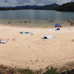
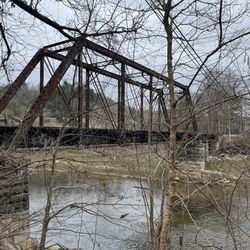
What a beautiful trail! There's plenty of free parking and it's open until 10 pm. Lake Chatuge straddles North Carolina and Georgia. You can catch glimpses of it from the Jackrabbit Mountain Recreation area (if you feel like hiking or mountain biking) but the beauty is near the dam. Built in 1941 and named after a Cherokee settlement, Chatuge Dam is 150 feet high and stretches 3,336 feet across the Hiwassee River. The Nantahala National Forest surrounds the dam and NC section of the reservoir, the Chattahoochee National Forest surrounds the GA section. Chatuge Dam Trail is 1.5 miles, paved and open to walkers, hikers, bikers and runners. It's ADA accessible, perfect for those with mobility issues and babies in strollers. The trail leads through the woods (where I didn't venture) and to two nearby campsites. The breathtaking views are stunning! Lake Chatuge reflects the sun so it looks different in the morning and in the evening. You're surrounded by some of the tallest mountains in Georgia, which are sometimes backlit with hues of purple. The colorful autumn leaves and the stillness of the lake really bring a sense of calm. There were families, couples strolling hand in hand, kids on bikes and seniors. The trail can be accessed from Chatuge Dam Road or Clay County Park which offers bathrooms, fishing access, a playground, ballpark, pavilions, camping & a small sandy beach with a swimming area. Pets on a leash are welcome! Chatuge Dam Trail is definitely worth a trip! read more

4 years ago
3 years ago
More info about Chatuge Dam Trail
1407 Chatuge Dam Rd
Hayesville, NC 28904
Directions
Hours
Outdoor Amenities


Chatuge Dam Trail - lakes - Updated July 2026
Best of Hayesville
People found Chatuge Dam Trail by searching for…
Swimming Holes in Hayesville, NC
Watch Sunset in Hayesville, NC
Things to Do in Hayesville, NC
Swimming Lakes in Hayesville, NC
Hiking Trails With Waterfalls in Hayesville, NC
Mountain Biking in Hayesville, NC
River Swimming in Hayesville, NC
Fishing Lake in Hayesville, NC
Walking Trails in Hayesville, NC
Baseball Fields in Hayesville, NC
State Parks Camping in Hayesville, NC
Scenic Drive in Hayesville, NC
Fishing Spots in Hayesville, NC
Free Parking in Hayesville, NC
Playgrounds for Kids in Hayesville, NC
Trending Searches in Hayesville, NC
Boat Tours near Chatuge Dam Trail
Boating near Chatuge Dam Trail
Cliff Jumping near Chatuge Dam Trail
Day Trips near Chatuge Dam Trail
Dog Friendly Beaches near Chatuge Dam Trail
Dog Friendly Things To Do near Chatuge Dam Trail
Dog Friendly Trails near Chatuge Dam Trail
Dog Swimming near Chatuge Dam Trail
Jet Ski Rental near Chatuge Dam Trail
Kayak Rental near Chatuge Dam Trail
Kids Activities Outdoor near Chatuge Dam Trail
Lookout Points near Chatuge Dam Trail
Off Road Trails near Chatuge Dam Trail
Peach Picking near Chatuge Dam Trail
Picnic Spots near Chatuge Dam Trail
Playgrounds near Chatuge Dam Trail
Public Shower near Chatuge Dam Trail
Rainy Day Activities near Chatuge Dam Trail
River Swimming near Chatuge Dam Trail
Rock Quarry near Chatuge Dam Trail
Scenic Overlook near Chatuge Dam Trail
Scenic Restaurants near Chatuge Dam Trail
Splash Pad near Chatuge Dam Trail
State Parks near Chatuge Dam Trail
Swimming Holes near Chatuge Dam Trail
Swimming Lakes near Chatuge Dam Trail
Things To Do On A Rainy Day near Chatuge Dam Trail
Things To Do With Kids near Chatuge Dam Trail
U Pick Farms near Chatuge Dam Trail
Watch Sunset near Chatuge Dam Trail
Browse Nearby
BEST of Hayesville, North Carolina Restaurants near Chatuge Dam Trail
BEST of Hayesville, North Carolina Things to Do near Chatuge Dam Trail
BEST of Hayesville, North Carolina Coffee near Chatuge Dam Trail
BEST of Hayesville, North Carolina Campgrounds near Chatuge Dam Trail
BEST of Hayesville, North Carolina Breakfast near Chatuge Dam Trail
BEST of Hayesville, North Carolina Shopping near Chatuge Dam Trail
BEST of Hayesville, North Carolina Wineries near Chatuge Dam Trail
Browse Brands
Related Searches in Hayesville, NC
Affordable Kayak Rental Services in Hayesville, North Carolina
Best Dog Hiking Trails Around Hayesville, North Carolina
Best Fishing Locations and Guides in Hayesville, North Carolina
Best Lookout Points to Visit in Hayesville, North Carolina
Best Parks for Parties and Events in Hayesville, North Carolina
Best Places for Horseback Riding in Hayesville, North Carolina
Best Pontoon Boat Rentals Near Hayesville, North Carolina
Best Water Parks for Kids in Hayesville, North Carolina
Best Waterfalls and Swimming Holes in Hayesville, North Carolina
Check Out Great Playgrounds in Hayesville, North Carolina
Check Out Off Road Trails in Hayesville, North Carolina
Discover Dog Friendly Trails to Explore in Hayesville, North Carolina
Discover Kid Friendly Hiking Trails in Hayesville, North Carolina
Discover Lakes & Ponds to Explore in Hayesville, North Carolina
Discover Popular Bike Trails in Hayesville, North Carolina
Discover Popular Photo Spots in Hayesville, North Carolina
Discover Scenic Mountain Bike Trails Near Hayesville, North Carolina
Discover Top Nature Parks to Visit in Hayesville, North Carolina
Discover Top State Parks to Visit in Hayesville, North Carolina
Discover a Hiking Trail in Hayesville, North Carolina
Discover the Best Beaches in Hayesville, North Carolina
Discover the Best Kids Park Spots in Hayesville, North Carolina
Discover the Best Night Hike Trails in Hayesville, North Carolina
Discover the Best Running Track in Hayesville, North Carolina
Dog-Friendly Hikes With Dogs in Hayesville, North Carolina
Enjoy Exciting Mountain Biking Adventures in Hayesville, North Carolina
Enjoy Hiking Adventures in Hayesville, North Carolina
Enjoy Kayaking Adventures in Hayesville, North Carolina
Enjoy Off Leash Dog Hikes in Hayesville, North Carolina
Enjoy Tent Camping Spots Around Hayesville, North Carolina
Enjoy the Best Picnic Spots and Ideas in Hayesville, North Carolina
Enjoy the Best Tubing Experiences in Hayesville, North Carolina
Enjoy the Best Walking Trails in Hayesville, North Carolina
Experience Thrilling White Water Rafting in Hayesville, North Carolina
Explore Beautiful Parks and Green Spaces in Hayesville, North Carolina
Explore Boat Rentals for Every Need in Hayesville, North Carolina
Explore Easy Hikes Perfect for All in Hayesville, North Carolina
Explore Family-Friendly Zoos and Wildlife in Hayesville, North Carolina
Explore Free Picnic Areas Around Hayesville, North Carolina
Explore Fun Activities to Do in Hayesville, North Carolina
Explore Parks With Lakes to Visit in Hayesville, North Carolina
Explore Parks With Pull Up Bars in Hayesville, North Carolina
Explore Picnic Parks Near Hayesville, North Carolina
Explore Popular Campgrounds Near Hayesville, North Carolina
Explore Popular Picnic Areas Around Hayesville, North Carolina
Explore Popular RV Parks Around Hayesville, North Carolina
Explore Scenic Lakes to Visit in Hayesville, North Carolina
Explore Secret Spots Worth Visiting in Hayesville, North Carolina
Explore Top Dog Parks in Hayesville, North Carolina Near You
Browse Articles
People who viewed Chatuge Dam Trail also viewed
High Shoals Falls Loop Trail
17 reviews
Blue Ridge Gap
1 review
Fires Creek Recreation Area
2 reviews
Brasstown Bald Tower
4 reviews
Meeks Park
25 reviews
Becky Branch Falls
2 reviews
Blue Ridge Mountain Kayaking
31 reviews
Piney Knob Trails
3 reviews
Wesser Bald Fire Tower
2 reviews
Mountain View Campground
9 reviews