Rattlesnake Ledge Trail Photos
 - Hiking Near Me")


More like Rattlesnake Ledge Trail
Recommended Reviews - Rattlesnake Ledge Trail
Start your review...

Reviews With Photos

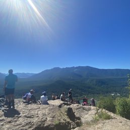
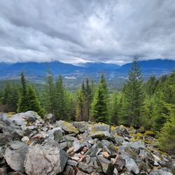
Lots of people out enjoying the great weather. Most people stopped at the lower ridge but I saw no other hikers venture up to the mid and upper ridges which had arguably better views. Lots of great spots to sit and have a snack while you take in the views. 5.72 miles, 1,460 elevation gain, 1 hr 57 minutes to complete.


A gorgeous and moderate/easy hike great for kids, pups, and everyone! We love that this trail is dog friendly! Who: My husband and I decided to do our first hike together with our senior pup who we carried up in our doggie backpack and let walk some of the way down. This hike took us around 3 hours because we took our time and also ate snacks at the top. It's got a steady incline to the top with some switchbacks. There are bathrooms at the start of the trail. Lots of parking but note that it fills up (especially later in the morning around 9am/10am) We went before 7am and there was plenty of parking. If you bring your pup, make sure to pack them water, snacks, and baggies if they poop and if they do, please pick it up! We want to keep the trails nice for everyone. :) The top of the hike was very pretty. Unfortunately, we came on a smoky day but still beautiful nonetheless.

What an experience a few days ago... I don't know if it's newer hikers on trails or humans who just don't give a f**k about how they destroy nature but this visit was abominable. First of all there was graffiti, dog poop bags, food wrappers and TP on the trail. You want to create art??? Take an art class or just spray paint YOUR own home. Want to bring your dog? Make sure it's on a leash AND you bring your Poop bags WITH you as you hike- DO NOT drop them down for any reason. Hungry and need to eat? Totally understandable but take your wrappers with you! And do NOT feed the wildlife even if the chipmunks are super cute AND come right up to you. Need to use the bathroom? There are two vault toilets AND porta potties AT the trailhead! Now for the matter that really stunk... if you choose to bring your kids hiking it is YOUR responsibility to keep them on trail, respect nature is for EVERYONE, and ripping branches off off trees while deep off trail is NOT OK!!! You are not special. You do not own the land we all get to use. If your kids need to play take them to a playground or let them go buck wild in YOUR HOME! Teach your kids to respect things that are not theirs!! Did I scold kids? You betcha Did these three kids change their behavior? Nope not until I started videoing their antics. Did the parents scold them? Nope not even close....they did however state their kids weren't doing anything wrong and I was the one who was unhinged- LIE. It's no wonder nature looks more and more worn out and beaten down over the last year. When humans come with an attitude that they can do whatever they want with their privilege it makes me want to wretch. Just remember you are not special and nature is not yours to treat like a garbage dump and dismember. You want to be a selfish idiot??? Be an idiot at your own home and wreck that.

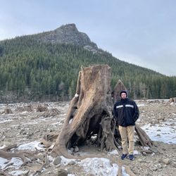
A pristine area with luscious green trees and gorgeous lake views. This is an awesome hike fueled with switch backs and lots of climbing. Be sure to wear those hiking boots cause it can cause a bit of a workout of those feets! The real winner with this hike is making it to the top for those incredible views and photo ops. It can get packed so please be patient, take your time, and remember hiking etiquette.

A fun easy hike but wayyy too many people and doggos. On weekends you will find yourself having to either pass people because you walk faster and people wont move out of the way or be the one to move out of the way because other people are faster than you. Dogs of all shapes and sizes are also seen here so bring your furry friend for pictutes. It is dog friendly and family friendly. Rattlesnake is an easy place to start if youre wanting to begin your journey as an avid hiker. There are inclines and flat spots but the inclines are minimal to mediocre. When you reach about 1.75 miles, you will see a sign that says to the right its the Rattlesnake Ledge and to the left you can continue 8 miles to Snoqualmie Point and about 2 miles to a higher point of Rattlesnake Trail (forgot the name of it, sorry). Most people stop at this ledge for thw pretty view and just to relax. You can definitely find yourself and others spending more than an hour here. The parking lot is always full, unless you go before 8 am or on a weekday then you have a lucky chance. Whether youre coming east or west, the minute you see the line of cars, you should start looking for side parking.

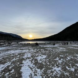
Spring in the PNW is downright amazing (specifically May 2024). The sun sets late and you can totally do this hike in the evening (I'm convinced it's a local's secret!) We arrived at 6:00PM and were immediately drawn to the lake. After capturing a few photos, we parked in the lot (plenty of parking available) and headed for the trail. We got a bit turned around at first (thinking the trail was off the parking lot; it's not) but eventually found the trailhead (it's off the lake, duh!). I am not a pro hiker by any means. I get regular 1 mile flat walks with my dogs a couple nights a week, so that should give you a sense of my level of fitness. According to my Apple Watch, to get this beautiful view of the lake, you only need to conquer 1,300ft change in elevation and just over 2 hours of your time! We started at 6:30PM and made it to the top by 8:00PM (mind you we took our time and were passed up quite a few times by what seemed to be locals just crushing it!). It took only 45 minutes to get back down. Please keep in mind that the parking lot closes at 9PM (there are signs everywhere) but what was helpful was that starting at 8:30PM, the rangers made loudspeaker announcements reminding visitors to make sure to exit the parking lot or risk being locked in AND fined!

Coming from Hawaii, I've done a couple of gruesome hikes where I felt like I should of stayed home instead of being outside. Most of our hikes overlook the ocean; coming to Seattle I wanted a change of scenery in hiking and that's how I came across Rattlesnake Ledge! The end result would be a view that overlooks a gorgeous lake and the best part was that it was only a 40 minute drive out the city and a pretty easy-moderate hike. First things first, when you google the hike for directions, search "Rattlesnake Lake" instead to get to the right destination. It's fairly easy to find from the parking lot (just look for the trashcan and multiple signs) the hike was simple; just follow the trail and keep going up. Overall, it's about a 2 mile hike and there are trail markers on the trees (3 red circles) letting you know how far in you are. I'd say it can take about an hour or so to go up depending how many breaks you take. Now I came on a terrible day....super cloudy and rainy so unfortunately I didn't get to see the beautiful end result you see from other pictures -sob- but I definitely didn't regret doing this hike. I got to see some critters and befriend a small bird, met a super nice couple from Minnesota, and got some cool picture moments. I definitely do this hike again but maybe next time go on a clear, sunny day
Beautiful hike! Parking can get crowded if you come later. The place is a little crowded too. It was around 4 mile round trip. Bring some food/snack to enjoy at the top :) The bathroom is not that clean :( would recommend to do it somewhere else. Other recommended activities: swim at the lake! The water isn't too cold :) many people bring their floaties and swimming suit

Came on a weekday morning around a quarter to 8AM, parking was on the street already but not too far of a walk. Hike was fine, all in the shade, not too steep, not too many people on the way up. There's 3 ledges: lower, mid, and upper - upper is really nice, we didn't stop at the other ones. Good view, nobody was there. Saw more people on the way down but wasn't too bad. Definitely would recommend coming on a weekday and not a weekend!

Some notes: -They have restrooms near the lake. -No parking pass needed and no parking fee! It is only slightly uphill and there aren't any especially difficult parts. Overall it was not a difficult hike for me although some of my teammates who don't hike as often were tired. My group took a lot of breaks so it took longer for us to get to the view but I'd say it should take about an hour or so to get to the top. When you get to the top, be careful as there are some gaps between the rocks. It took about 45 minutes to go back down. As we were going up there were no mile marker signs until we got to the peak where we stopped. We came across a fork in the road where we could've continued going up for a higher view but we decided to stay where we were. We came on a Wednesday (hooray for team hike!) in January and there were very few people. It was completely quiet at some points which felt nice and calm. I'm sure it's different compared to a weekend in the summer. There was tons of parking when we went but there is also an extra parking lot for when there are lots of people. It was a pretty chill hike that ended with beautiful views of the lake and the landscape. Make sure to take it all in with some lunch!

Super fun hike pretty much straight up for just over two miles. Following switch backs back and fourth up to the top of Rattlesnake Peak you go up and up high above the lake. When reaching the top you are awarded with pristine views of the lake and miles beyond of green forest. I loved looking at the trees from high above rolling like an ocean of green. On this day it was extremely windy at the top and fairly crowded. One of my hiking companions who is familiar with the area said it could be busier. It is really dry right now, the driest October in WA since 1987, so there was a lot of dust. The trail is extremely gravely so watch your footing. If you are afraid of heights, like I am, the top can be fairly scary. Lots of room to sit and enjoy a lunch if you brought one, we did not. Walking around at the top did cause a bit of scare, but no worries a friendly hand helped me hop up to a safer area. Plenty of parking below and bathrooms at the bottom. Bring water, bring a friend, go hiking here. Happy Yelping.

Nice trail, came on a Saturday at 8am and was able to find parking in the main lot easily. Got pretty crowded on the trail after 10am. Seeing lots of dog poop bags near the trailheads very disappointing to see, pick up after yourselves and leave no trace!! read more


This is my Go-To trail to take anyone visiting! Best bite-sized PNW hike. It is 12/10 on the reward-to-effort ratio. It's just hard enough to feel like a challenge (in a good way) but not too hard that it's not fun anymore for a non-hiker. The summit is stunning - you can see the lake and a blanket of beautiful evergreens from the top. Plenty of parking and places to picnic at the base too. The only con - it can get REALLY crowded as it is a popular hike, but hey make some new friends and see some cute dogs ^__^ read more


7 months ago
Plenty of parking and well-maintained trail. We missed out on the epic views because it was raining and foggy but still enjoyed it. I have heard it gets really busy during the summer and even on a rainy day there were a decent amount of people out. Most people seem to stop at the lower ledge but not many went to the middle and upper ledges. Will definitely come back on a clear day to actually take in the views! read more


Lots of people out enjoying the great weather. Most people stopped at the lower ridge but I saw no other hikers venture up to the mid and upper ridges which had arguably better views. Lots of great spots to sit and have a snack while you take in the views. 5.72 miles, 1,460 elevation gain, 1 hr 57 minutes to complete. read more


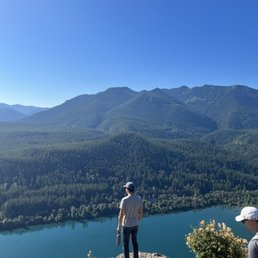
This is such a beautiful hike that is worth it! You climb 1100 feet in elevation. The viewpoint from the top is stunning. The trees with the different heights and shades of green look like a wave of trees. You see the mountain range on the left and a light emerald lake. read more


A gorgeous and moderate/easy hike great for kids, pups, and everyone! We love that this trail is dog friendly! Who: My husband and I decided to do our first hike together with our senior pup who we carried up in our doggie backpack and let walk some of the way down. This hike took us around 3 hours because we took our time and also ate snacks at the top. It's got a steady incline to the top with some switchbacks. There are bathrooms at the start of the trail. Lots of parking but note that it fills up (especially later in the morning around 9am/10am) We went before 7am and there was plenty of parking. If you bring your pup, make sure to pack them water, snacks, and baggies if they poop and if they do, please pick it up! We want to keep the trails nice for everyone. :) The top of the hike was very pretty. Unfortunately, we came on a smoky day but still beautiful nonetheless. read more


2 years ago
What an experience a few days ago... I don't know if it's newer hikers on trails or humans who just don't give a f**k about how they destroy nature but this visit was abominable. First of all there was graffiti, dog poop bags, food wrappers and TP on the trail. You want to create art??? Take an art class or just spray paint YOUR own home. Want to bring your dog? Make sure it's on a leash AND you bring your Poop bags WITH you as you hike- DO NOT drop them down for any reason. Hungry and need to eat? Totally understandable but take your wrappers with you! And do NOT feed the wildlife even if the chipmunks are super cute AND come right up to you. Need to use the bathroom? There are two vault toilets AND porta potties AT the trailhead! Now for the matter that really stunk... if you choose to bring your kids hiking it is YOUR responsibility to keep them on trail, respect nature is for EVERYONE, and ripping branches off off trees while deep off trail is NOT OK!!! You are not special. You do not own the land we all get to use. If your kids need to play take them to a playground or let them go buck wild in YOUR HOME! Teach your kids to respect things that are not theirs!! Did I scold kids? You betcha Did these three kids change their behavior? Nope not until I started videoing their antics. Did the parents scold them? Nope not even close....they did however state their kids weren't doing anything wrong and I was the one who was unhinged- LIE. It's no wonder nature looks more and more worn out and beaten down over the last year. When humans come with an attitude that they can do whatever they want with their privilege it makes me want to wretch. Just remember you are not special and nature is not yours to treat like a garbage dump and dismember. You want to be a selfish idiot??? Be an idiot at your own home and wreck that. read more


1 year ago
4 years ago
A pristine area with luscious green trees and gorgeous lake views. This is an awesome hike fueled with switch backs and lots of climbing. Be sure to wear those hiking boots cause it can cause a bit of a workout of those feets! The real winner with this hike is making it to the top for those incredible views and photo ops. It can get packed so please be patient, take your time, and remember hiking etiquette. read more


5 years ago
A fun easy hike but wayyy too many people and doggos. On weekends you will find yourself having to either pass people because you walk faster and people wont move out of the way or be the one to move out of the way because other people are faster than you. Dogs of all shapes and sizes are also seen here so bring your furry friend for pictutes. It is dog friendly and family friendly. Rattlesnake is an easy place to start if youre wanting to begin your journey as an avid hiker. There are inclines and flat spots but the inclines are minimal to mediocre. When you reach about 1.75 miles, you will see a sign that says to the right its the Rattlesnake Ledge and to the left you can continue 8 miles to Snoqualmie Point and about 2 miles to a higher point of Rattlesnake Trail (forgot the name of it, sorry). Most people stop at this ledge for thw pretty view and just to relax. You can definitely find yourself and others spending more than an hour here. The parking lot is always full, unless you go before 8 am or on a weekday then you have a lucky chance. Whether youre coming east or west, the minute you see the line of cars, you should start looking for side parking. read more


Spring in the PNW is downright amazing (specifically May 2024). The sun sets late and you can totally do this hike in the evening (I'm convinced it's a local's secret!) We arrived at 6:00PM and were immediately drawn to the lake. After capturing a few photos, we parked in the lot (plenty of parking available) and headed for the trail. We got a bit turned around at first (thinking the trail was off the parking lot; it's not) but eventually found the trailhead (it's off the lake, duh!). I am not a pro hiker by any means. I get regular 1 mile flat walks with my dogs a couple nights a week, so that should give you a sense of my level of fitness. According to my Apple Watch, to get this beautiful view of the lake, you only need to conquer 1,300ft change in elevation and just over 2 hours of your time! We started at 6:30PM and made it to the top by 8:00PM (mind you we took our time and were passed up quite a few times by what seemed to be locals just crushing it!). It took only 45 minutes to get back down. Please keep in mind that the parking lot closes at 9PM (there are signs everywhere) but what was helpful was that starting at 8:30PM, the rangers made loudspeaker announcements reminding visitors to make sure to exit the parking lot or risk being locked in AND fined! read more


- May 2024 - Hiking Near Me")


 - Hiking Near Me")
Coming from Hawaii, I've done a couple of gruesome hikes where I felt like I should of stayed home instead of being outside. Most of our hikes overlook the ocean; coming to Seattle I wanted a change of scenery in hiking and that's how I came across Rattlesnake Ledge! The end result would be a view that overlooks a gorgeous lake and the best part was that it was only a 40 minute drive out the city and a pretty easy-moderate hike. First things first, when you google the hike for directions, search "Rattlesnake Lake" instead to get to the right destination. It's fairly easy to find from the parking lot (just look for the trashcan and multiple signs) the hike was simple; just follow the trail and keep going up. Overall, it's about a 2 mile hike and there are trail markers on the trees (3 red circles) letting you know how far in you are. I'd say it can take about an hour or so to go up depending how many breaks you take. Now I came on a terrible day....super cloudy and rainy so unfortunately I didn't get to see the beautiful end result you see from other pictures -sob- but I definitely didn't regret doing this hike. I got to see some critters and befriend a small bird, met a super nice couple from Minnesota, and got some cool picture moments. I definitely do this hike again but maybe next time go on a clear, sunny day read more


Beautiful hike! Parking can get crowded if you come later. The place is a little crowded too. It was around 4 mile round trip. Bring some food/snack to enjoy at the top :) The bathroom is not that clean :( would recommend to do it somewhere else. Other recommended activities: swim at the lake! The water isn't too cold :) many people bring their floaties and swimming suit read more


Came on a weekday morning around a quarter to 8AM, parking was on the street already but not too far of a walk. Hike was fine, all in the shade, not too steep, not too many people on the way up. There's 3 ledges: lower, mid, and upper - upper is really nice, we didn't stop at the other ones. Good view, nobody was there. Saw more people on the way down but wasn't too bad. Definitely would recommend coming on a weekday and not a weekend! read more


Some notes: -They have restrooms near the lake. -No parking pass needed and no parking fee! It is only slightly uphill and there aren't any especially difficult parts. Overall it was not a difficult hike for me although some of my teammates who don't hike as often were tired. My group took a lot of breaks so it took longer for us to get to the view but I'd say it should take about an hour or so to get to the top. When you get to the top, be careful as there are some gaps between the rocks. It took about 45 minutes to go back down. As we were going up there were no mile marker signs until we got to the peak where we stopped. We came across a fork in the road where we could've continued going up for a higher view but we decided to stay where we were. We came on a Wednesday (hooray for team hike!) in January and there were very few people. It was completely quiet at some points which felt nice and calm. I'm sure it's different compared to a weekend in the summer. There was tons of parking when we went but there is also an extra parking lot for when there are lots of people. It was a pretty chill hike that ended with beautiful views of the lake and the landscape. Make sure to take it all in with some lunch! read more


4 years ago
Super fun hike pretty much straight up for just over two miles. Following switch backs back and fourth up to the top of Rattlesnake Peak you go up and up high above the lake. When reaching the top you are awarded with pristine views of the lake and miles beyond of green forest. I loved looking at the trees from high above rolling like an ocean of green. On this day it was extremely windy at the top and fairly crowded. One of my hiking companions who is familiar with the area said it could be busier. It is really dry right now, the driest October in WA since 1987, so there was a lot of dust. The trail is extremely gravely so watch your footing. If you are afraid of heights, like I am, the top can be fairly scary. Lots of room to sit and enjoy a lunch if you brought one, we did not. Walking around at the top did cause a bit of scare, but no worries a friendly hand helped me hop up to a safer area. Plenty of parking below and bathrooms at the bottom. Bring water, bring a friend, go hiking here. Happy Yelping. read more


It's a great hike, it's uphill but not to bad. The view is great once you're up there, you can see the lake and the mountains. If it's a hot day bring your swimming suit and jump in the water! You need to have the discover pass to park. read more


I have done RattleSnake hike many times and love it each time I go. It's a hike I will take someone to if they are visiting Seattle and enjoy hikes. It is a very popular trail so beat the crowds by going early! It is dog and family friendly. I recommend going before 9AM because the parking gets full very quickly especially on the weekend or when it's nice out. There are a couple different trails, but I have only done the ~4 mile out and back and is mostly shaded because of all the trees. It is a moderate hike with flat and slight inclines throughout the trail. It is almost impossible to get lost on this trail because the trail paths are very clear. It is rocky here and there but you can get by with good athletic shoes. The view at the ledge is unbeatable with the trees and blue lake at the bottom. It is a great spot to chill, eat your snacks, and take a good photo for the gram. read more


8 years ago
I've been to Rattlensake Ledge twice now, and it's always a fun hike. It's fairly easy. Although slightly steep, the elevation gain isn't too bad. It's honestly and enjoyable, short hike. The last time, I came on a sunny (slightly smokey) Sunday morning. We got to the parking lot around 7:30 AM and it was already half full. There were a couple of people on the trail. When we got to the top, the view was amazing. It's hard to imagine we only hike up 2 miles for that view. My friends and I hung out for a little bit at the top, and when we left it was getting pretty crowded on that rock already. We headed back down around 9:20ish and it was packed. We saw so many groups headed up, one after another. Definetely try to start the hike before 9 am on the weekends, it gets super crowded. When we finally got back down, the parking lot was full, and people were waiting for spots. But enough people were leaving, so it might not be too bad to find a spot. There are porta potties at the trailhead as well. We'll probably be back here to take visitors that come here who want to hike but prefer a shorter one. read more

7 years ago
Pretty chill hike! Elevation gain isn't bad. Hike is totally doable in a morning, so it's perfect if you want a short hike that doesn't take up the whole day. Nice views at the top, close to the city- no wonder it's one of the more popular hikes in Washington. Plan to come early, or else the parking situation might be bad. read more


2 years ago
7 years ago
9 years ago
Great hiking trail around the North Bend. There's a park with a lake with the view of the mountain where people go to chill, BBQ, and even kayak. There are a couple different trails, the longest being 13 miles. I went for the 4 mile route, which leads up to an amazing view and worth the struggle going up. It's not a difficult hike but you're walking at a constant incline so you will feel your legs ache the next day! Usually it's crowded on weekends so if you want a more peaceful experience, I would go sometime in the beginning of the week. It's absolutely breathtaking when you get up there, makes you think about life and shit and question your existence. Haha just kidding, but you do become one with nature and it's just a good feeling being on top. It's better to go in the warmer months too because of the obvious snow and cold weather in the winter. Definitely should be on your bucket list if you live in Washington state! read more


7 years ago
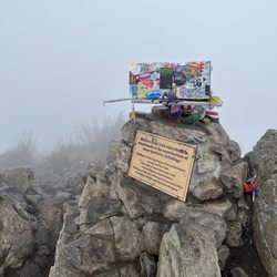
I really want to emphasize that you should start this trail as early as possible in the morning! My boyfriend and I started this trail a little before 8am on a Monday (and we spent some time by the lake) and by the time we reached the top at ~9:30 there weren't many people. It was quiet, calm, and a fun viewing experience. But by the time we hiked down around 10-11am there were CROWDS of people. The top of this hike is not a place where you want a lot of people. There isn't any particularly safe place to stand so I couldn't imagine maneuvering with a lot of people around . The coordinates to the parking lot is 47.4335, -121.7675. There are bathrooms at the start of the trail NOT by the parking lot (0.3mi walk to the start of the trail) The whole trail is in between trees so it's nice and shady and you don't need to wear sunscreen unless your skin is really sensitive. And if you're scared of heights the top is a bit scary but the whole trail is fine. read more

A pass is not required to hike this trail. Free parking can be found in the large parking lot. Park gates are open from 6am-6pm. A picnic area is offered for those not interested in hiking. The parking lot does fill up quickly. Street parking is available if the parking lot is full. Privy's are available at the beginning of the trail. This trail is enjoyed by many so practice good hiking etiquette. Several hikers were accompanied by their four legged friends. Elevation gain is 1100+ feet. Round trip is about 4 miles. Expect to work and sweat during this climb. The trail is well maintained. I wouldn't suggest this trail for those who are handicapped. Viewing the gorgeous scenery from the sheer rock cliff at the summit is both breathtaking and humbling at the same time. Pat yourself on the back and enjoy some well deserved snacks while appreciating beautiful Mother Nature before descending. Remember, if you pack it in, pack it out. read more


7 years ago
**Google Maps "Rattlesnake Lake" and you'll get there safely and correctly** The hike itself is 2 miles altogether, and there is a little small trail that leads up to the actual trail. You know you're going the right way when you come upon a gate! Upon the hike, the trail is pretty quiet and the elevation is pretty beginner friendly. I'm absolutely horrible at hikes but it took me an hour to hike from bottom to the top with a generous amount of breaks along the way. For anyone that wants a sunrise hike, as of this review, you should start the hike around 4:30am and you'll be in good shape to catch an amazing sunrise. The parking lot has no cameras and the bathrooms aren't the best, but that's usually the case for hikes such as these. Cheers! read more


7 years ago
One of the most hiked trails off of I90 corridor. Parking is limited so please arrive early. On a nice day, parking lot will potentially get full by 8am and hikers will start parking on the side of the road, sometimes that adds another mile to the hike. If you start hiking later in the day, on this trail, you may not find a parking. The trail will get very busy - constant foot traffic so difficult to have that quiet moment on the trail. Once you get to the top, on a busy day the ledge will most likely be full. The view is phenomenal. The hike is beautiful. Just get there early. I have taken many of my family members (non hikers or first time hikers) and each one of them have enjoyed this hike. read more

People recommended for me to arrive before 10 AM or parking can be tough to find since so many people want to come to this place. Out of all the hikes I've been on, this place had one of the coolest views! Really awesome view overlooking the valley, lake, and other mountains like Mount Si. The hike up and back from the ridge took our group about 3 hours in total, including taking pictures and just chilling at the ridge. It's a hike of 2 miles with some switchbacks, not too tough but you should bring some water and snacks. I know this place has some other trails to the summit, a bit longer to the top. I'll be back to try them further! There's also a ton of friendly chipmunks. They have no qualms about running up to you and snatching away food. read more


3 years ago
4 years ago
7 years ago
AN AMAZING SHORT HIKE 1. DISTANCE: The hike is 3.8 miles round trip exactly. Lots of websites try to add a mile and say it's 5 miles. Not sure why they lie. The sign at the bottom says 1.9 miles to the top thus 1.9 miles back down since you go down exactly the way you come up. 2. DIFFICULTY: I hardly saw people on the trail when I went (on a weekday) but yet when I got to the top there were lots of families hanging out and eating their food they brought. I saw lots of little kids so the difficulty isn't too bad. The only hard part I would say is that the whole way up is just that, it's UPHILL. So you might get a little tired but it's not that bad. Bring a water bottle and maybe a granola bar. Also the trail is covered with trees so not much direct sun if you chose to go on a hot day you should still be fine because of all the shade they provide. 3. VIEWS: It is absolutely breathtaking. I've never hiked such a short hike with such pretty views. It's 360 degrees at the top with a beautiful view of the lake. 4. PARKING: it's free. There's a parking lot and very. Clear signs on how to start the hike. Plus bathrooms at the bottom 10/10 I would recommend going. read more


5 years ago
Have been coming to this spot for years and it gets more beautiful yet crowded every time. I see why. This last time we chose to start at 5am and made the sunrise which was nice because there was no more than 10-15 people up there with us too. Not everyone wore masks but I don't blame them, the incline was hell, we all needed to breath. Amazing place, perfect for all ages and dogs. read more


Page 1 of 6
More info about Rattlesnake Ledge Trail
North Bend, WA 98045
Directions
Visit Website
http://www.wta.org/go-hiking/hikes/rattle-snake-ledge
Hours
Indoor Amenities
Outdoor Amenities
Ask the Community - Rattlesnake Ledge Trail
Any strollers on this hike?
I don't believe I saw anybody with strollers. Most parents either carried small infants or the children were old enough to walk themselves. Not an ideal path to push a stroller.
Is this trail safe to hike in the rain?
On a normal day it was a light challenge going up but tiring going down due the downward angles and the number of stairway step-downs. In the rain, the descent would require extra care. I'd suggest taking a hiking pole.
Is this wise to attempt mid day on a sunny Saturday like today or will be too crowded with us and our lab to enjoy the hike?
Not mid day. Difficult to find parking and the trail will be crowded. Come earlier in the day
Review Highlights - Rattlesnake Ledge Trail


Why does Yelp recommend reviews?
Rattlesnake Ledge Trail - hiking - Updated June 2026
Best of North Bend
People found Rattlesnake Ledge Trail by searching for…
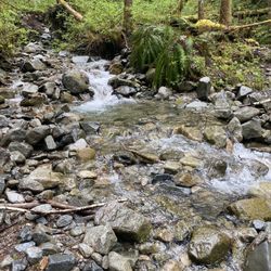
Hiking Trails With Waterfalls in North Bend, Washington
Things to Do in North Bend, Washington
Swimming Lakes in North Bend, Washington
Beaches in North Bend, Washington
Places to Take Pictures in North Bend, Washington
Scenic Drive in North Bend, Washington
Parks in North Bend, Washington
Sunset View in North Bend, Washington
Scenic View in North Bend, Washington
Waterfalls and Swimming Holes in North Bend, Washington
Photo Spots in North Bend, Washington
Easy Hikes in North Bend, Washington
Scenic Spots in North Bend, Washington
Dog Friendly Beaches in North Bend, Washington
Lookout Points in North Bend, Washington
Playgrounds in North Bend, Washington
Sunrise View in North Bend, Washington
Watch Sunset in North Bend, Washington
Dog Friendly Parks in North Bend, Washington
Flower Fields in North Bend, Washington
Rattlesnake in North Bend, Washington
Sunrise Hike in North Bend, Washington
Trending Searches in North Bend, WA
Black Owned Nail Salons near Rattlesnake Ledge Trail
Boat Rental near Rattlesnake Ledge Trail
Cliff Jumping near Rattlesnake Ledge Trail
Creeks near Rattlesnake Ledge Trail
Day Trips near Rattlesnake Ledge Trail
Dog Friendly Trails near Rattlesnake Ledge Trail
Fireworks near Rattlesnake Ledge Trail
Fishing Spots near Rattlesnake Ledge Trail
Jet Ski Rental near Rattlesnake Ledge Trail
Kayak Rental near Rattlesnake Ledge Trail
Lakes & Ponds near Rattlesnake Ledge Trail
Outdoor Activities near Rattlesnake Ledge Trail
Places To Walk Around near Rattlesnake Ledge Trail
Public Pools near Rattlesnake Ledge Trail
Public Shower near Rattlesnake Ledge Trail
River Swimming near Rattlesnake Ledge Trail
Rock Quarry near Rattlesnake Ledge Trail
Scenic Night View near Rattlesnake Ledge Trail
Scenic Overlook near Rattlesnake Ledge Trail
Secluded Spots near Rattlesnake Ledge Trail
Soccer Store near Rattlesnake Ledge Trail
Splash Pad near Rattlesnake Ledge Trail
Strawberry Picking near Rattlesnake Ledge Trail
Sunrise View near Rattlesnake Ledge Trail
Swimming Holes near Rattlesnake Ledge Trail
Swimming Lakes near Rattlesnake Ledge Trail
Watch Sunset near Rattlesnake Ledge Trail
Browse Articles
Browse Nearby
BEST of North Bend, Washington Restaurants near Rattlesnake Ledge Trail
BEST of North Bend, Washington Coffee near Rattlesnake Ledge Trail
BEST of North Bend, Washington Walking Trails near Rattlesnake Ledge Trail
BEST of North Bend, Washington Things to Do near Rattlesnake Ledge Trail
BEST of North Bend, Washington Breakfast near Rattlesnake Ledge Trail
BEST of North Bend, Washington Parks near Rattlesnake Ledge Trail
BEST of North Bend, Washington Campgrounds near Rattlesnake Ledge Trail
BEST of North Bend, Washington Caves near Rattlesnake Ledge Trail
BEST of North Bend, Washington Hot Springs near Rattlesnake Ledge Trail
Browse Brands
Related Searches in North Bend, WA
Affordable Kayak Rental Services in North Bend, Washington
Best Fishing Locations and Guides in North Bend, Washington
Best Nature Trails for Hiking in North Bend, Washington
Best Places for Horseback Riding in North Bend, Washington
Check Out Off Road Trails in North Bend, Washington
Discover Dog Friendly Trails to Explore in North Bend, Washington
Discover Scenic Mountain Bike Trails Near North Bend, Washington
Discover Scenic Waterfall Spots in North Bend, Washington
Discover Top Nature Parks to Visit in North Bend, Washington
Discover Walking Parks in North Bend, Washington Near You
Discover a Hiking Trail in North Bend, Washington
Discover the Best Night Hike Trails in North Bend, Washington
Dog-Friendly Hikes With Dogs in North Bend, Washington
Enjoy Camping Adventures Around North Bend, Washington
Enjoy Exciting Mountain Biking Adventures in North Bend, Washington
Enjoy Kayaking Adventures in North Bend, Washington
Enjoy Tent Camping Spots Around North Bend, Washington
Enjoy a Beautiful Waterfall Hike in North Bend, Washington
Enjoy the Best Picnic Spots and Ideas in North Bend, Washington
Enjoy the Best Walking Path in North Bend, Washington
Enjoy the Best Walking Trails in North Bend, Washington
Experience Thrilling White Water Rafting in North Bend, Washington
Explore Beautiful Parks and Green Spaces in North Bend, Washington
Explore Easy Hikes Perfect for All in North Bend, Washington
Explore Fun Activities to Do in North Bend, Washington
Explore Popular Campgrounds Near North Bend, Washington
Explore the Best Beach Spots in North Bend, Washington
Explore the Best Swimming Holes Around North Bend, Washington
Explore the Best Trail Options in North Bend, Washington
Family Friendly Hiking With Kids in North Bend, Washington
Find Beautiful Views in North Bend, Washington
Find Popular Ziplining Spots Around North Bend, Washington
Find the Best Parks for Picnics in North Bend, Washington
Find the Best Scenic View Locations in North Bend, Washington
Great Places to Walk in North Bend, Washington
Hike the Popular Waterfall Trail in North Bend, Washington
Hiking Trails With Waterfalls in North Bend, Washington
Off Leash Dog Hiking Trails in North Bend, Washington
Plan a Scenic Drive Route Near North Bend, Washington
Popular Outdoor Activities to Try in North Bend, Washington
Popular Picnic Spots to Visit in North Bend, Washington
Safe River Swimming Areas in North Bend, Washington
Safe and Fun Parks for Kids in North Bend, Washington
Top Climbing Spots and Gyms in North Bend, Washington
Top Paddleboarding Activities in North Bend, Washington
Top Running Trails to Explore in North Bend, Washington
Top Swimming Lakes to Enjoy in North Bend, Washington
Top Swimming Spots and Pools in North Bend, Washington
Walk Dog Friendly Hiking Trails in North Bend, Washington
Walk the Best Paved Walking Trails in North Bend, Washington