Mount Si Photos


You might also consider
More like Mount Si
Recommended Reviews - Mount Si
Start your review...

Reviews With Photos

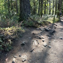
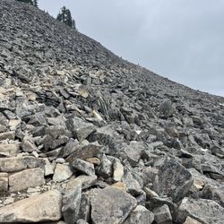
It's a strenuous hike. Be prepared to sweat baby, sweat. It's been on my bucket list for awhile and am finally happy to say that I've summited Mount Si. Wake up early and go! I woke up around 5:30am, arrived from Bellevue to North Bend at 6am, and there were already a handful of cars. The parking lot is larger than other trailhead parking lots around, but it gets full. It's also further down the Little Si parking lot, with signs indicating where to go. By the time I left there were cars circling around, stalking those hikers who were on their way out. Get here early, peeps! Also, be careful when you arrive to the parking lot because the gravel road was fulllll of potholes. Go slow and steady. I'd recommend driving a vehicle with AWD, as some of the potholes were really deep. Discover Pass is required. The hike is about four miles up, so eight miles roundtrip. It's strenuous in that, it's long. It especially feels like it when you're going on steeper inclines, but the trail is very well-managed. It's also much wider than other trails in the area, making it possible to socially distance from one another. The hike will have you trek through the forest much of the time, to help keep cool. There were also areas with benches where you can stop and take a break. When you're near the summit, there's a map that shows you're only 0.3 miles away from the top. There, you will end up scrambling as the area is all rock form. It's a pretty easy climb. The challenge will be for those going to Haystack Rock, which is the true summit of this hike. The views of Mount Rainier and the Snoqualmie Valley area are what you'll see first once you reach the top. But if you go back towards Haystack Rock, there's another viewpoint where you can see the Bellevue area. Many people took a break around the rocks to eat and enjoy the sights. This was an awesome hike that had my knees and feet sore! Going up was hard because it's a workout, but going down was actually harder for me because of how bad my knees and feet felt. I would recommend bringing hiking poles if you have 'em. Other than being sore the next day, it was a rewarding challenge and would recommend anyone wanting a good, long hike to check out Mount Si.

Just got back home from the hardest hike I've ever done. Started off my hike at 545am. There was already one person ahead of me and one person behind me. Definitely recommend waking up early for the hike. Discovery pass required. I ordered online but my pass never came so I just wrote down the transaction and enforcement # and placed it on my dash. I had no problems with that. Now the hike..... I started off at the Mount Si parking lot. Kept walking up very steep incline (30-45 degree it seemed like) for maybe 1 mile+ straight. Then there's a bit of downhill for a while and then more uphill climb. I don't know where I went wrong but I eventually ended up to the sign where it tells me that I have 0.3 miles to go till I reach the top. Unfortunately the snow had covered most of the trail and was very obscured. By the time I noticed that I was wandering aimlessly, following what looked like foot steps to me, I was in the middle of nowhere with no trail in sight. I WAS LOST Luckily a very nice gentleman named Chris was just 100ft from me so I yelled out for help. I climbed rocks and eventually got to where he was standing. We both attempted to find the trail to the overlook but unfortunately we both decided that it was not safe so we turned back around. If it wasn't for Chris I would have had a very difficult time even finding my way back down. On my way down I was once again hiking solo and wandered all the way to the Teneriffee parking lot. I asked the very nice couple standing by the entrance where I was and they said I was about 1 mile away from Mount Si parking lot. I nearly cried. But the nice lady, Penny drove me back and all is well. My bad knees are in pain. So confused as to how people are saying this hike is only 8 miles when I'm sure I did like 13 miles with 35,0000 steps logged on my fitness watch. If someone knew what I did please let me know lol. As someone who is a first timer hiking this particular hike and hiking it solo... I don't recommend. But I give it five stars because it was beautiful. I just wish that I could have finished the hike.
Came on a Saturday morning around 10AM, parking lot had many cars but lots of space, rainy cloudy day though that was forecasted to rain. Path was steadily uphill but not too steep, pretty narrow though. Thankfully not too many people on the trails. Views at the top were just okay since the rain clouds were covering a lot of the view. Having stayed up there for a bit, the clouds moved away and more of the view came out. Not too crowded at the top, and the way down was fine too. It started raining a lot more and got a bit cold. Good hike, but probably wait for good weather!

Beautiful hike for the able bodied. This is well worth the effort and the difficulty level is on the far end of moderate. Stunning views from the top! Parking at the trail head is ample and there is a convenient pit toilet for services. Pretty breezy above the tree line, definitely dress in layers for the transition in and out of the wood line in the colder months. Check the weather report and prepare for snowy/icy conditions for the final leg at the top during the winter. Didn't see any sign or wildlife as this trail appears to be regularly frequented. All in all, another breathtaking sight of everything to love about the PNW.


!!WARNING!! This hike is not for first time goes. Having said that, we had a really great time. For things to know before you go scroll down to the * Our group ranged from 18-45 y/o, with both male n females. The trek up is a workout on your legs, recommend taking a walking stick and at least 1-2 quarts of water and snacks. The trail keeps going up from the start to the top. It's a lil over 4 miles & some change up and believe me after mile 2 you really feel it, but once you hit 3.5 you can almost taste the top. Be sure to take rest breaks along the way and you'll be GTG. Our group didn't take any breaks bc we're all hard chargers, but if I was taking my fam, yeah we would have stopped n rested intermittently. Dogs are welcome, but please don't leave the poop bags on the trail. I seen a hiker with a Dodson and thought...Y you doing that to them? This is more for large to medium size dogs, small ones might injure themselves. If you take your puppers bring them water n something to eat too, they will be eternally grateful The trip down was the best feeling! Having worked so hard going up, I dang near jogged the whole way down. Some parts be careful, but you'll see the tricky steps. After all was said n done we chilled in the parking lot and enjoyed the day. *Skill lvl 4 hike, mostly incline Parking lot requires Discovery pass.(might be able to get a temp pass if ranger is there) Lots of potholes in the parking lot Don't leave valuables/electronics in cars Bring 1-2 quarts of water n snacks Walking stick recommend LRG-MED dogs, may not be suitable 4 small dogs Take breaks, and clean-up after yourself Dress in layers n bring a backpack to downgrade as needed Bathroom is only at the base n you might need a gas mask

This climb is so killer. The 4 miles in is entirely uphill and enclosed by trees, so there isn't much to focus on except for the undeniable pain in your quads that slowly starts to creep in. But, if you can get past that pain and keep moving one foot in front of the other, eventually you'll reach the top, and boy, is that view something else. It is so gratifying when you finally get to the top. It was a clear day when I went, and I could see all the way to Seattle. There was a bit more climbing to do on a rocky surface to get to a better viewing area however. That was definitely worth the climb because you got more of a 360-view with tons of photo opportunities. From this peak there was also access to higher mountain peak, but from what I gathered it was an almost vertical scaling of the mountain side with fewer safety features and many posted "caution" signs. I wouldn't say I'm scared of heights really, but extreme heights and a lack of security tends to make my palms sweaty. So I was happy staying on the lower, safer peak! After you take in the view, get your pictures in, and catch your breath, enjoy the 4-mile return trip downhill. If my college anatomy course taught me anything, though, it's the downhill portion of a hike that will make you sore the next day. :D

This hikes is easily accessible and just a couple minutes from the freeway exit! It was refreshing to not have to drive a whole bunch of switchbacks to get to a trailhead. From Kent, it's a quick 45 minute drive. In order to park in the lot, you have to have a discovery pass, which you can buy online and print at home for $11.50. Make sure you do this before going to the hike because there isn't a ranger there who sells the discovery pass. The hike is pretty much completely shaded the entire time except for the summit. You're surround by the beautiful Washington woods. It's a major workout! You're going uphill pretty much the entire time. You climb over 4,000 ft in elevation in just 4 miles. It took my boyfriend and 2 hours to the top and and hour and 40 minutes to the bottom. The view at the top is worth all the hard work! The birds at the summit are so cute and friendly too. They were landing on our hands and feet!

For two "hikers" this one is a must try once. We haven't hiked in at least a year and heard mixed reviews on level of difficulty. It's a constant upward hike with very few flat parts. We brought 5 bottles of water for two and went through almost all of them on the way up. It goes through mostly wooded areas with limited sun so being light layers you can shed as needed. Wear good shoes and bring snacks. Most importantly take your time and feel free to take breaks if it gets a bit much. The view at the very top is worth it.

This hike is as challenging as everyone makes it out to be. It's a steep hike, and the scenery on the way to the top is a bit boring. But once you make it to the top, you'll realize that the dud scenery and heavy panting was all worth it. At the top the view is absolutely stunning; great views of mountains and there are a lot of colorful plants as well. It's also a rock-climber's paradise. I don't have much climbing experience, but there are a lot of opportunities to climb around. I wanted to climb to the top of this one lookout point, but given that I was hiking by myself and given that I don't have much experience climbing, I didn't think it was the wisest idea. I made it about halfway up and decided to stop. I probably could've made it to the top but it was very steep and I began thinking, "I may be able to make it to the top, but how am I going to get down?" I hiked this three times last summer, once when it was foggy and twice when it was clearer. I enjoyed the hike all three times. Just make sure that you eat enough beforehand and bring enough water and snacks for the trek.

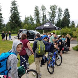
Extra star to King County for the excellent direct-to-trailhead bus service - a truly great service to the community that serves multiple goals (less traffic! easier access to hikes!). I was impressed by the number and diversity of people I saw using this service. Thanks King County! As for the trail itself, eh. Pros: The payoff was pretty fantastic, and it sure is a good workout. It's under tree cover the whole time too, so it stays a comfortable temperature. Big con: the scenery does. not. change the entire hike. 4+ hours of looking at the same thing all the way up and down. This hike is really more about the destination than the journey. I prefer hikes that hold your interest throughout. This hike is worth doing, but it's not a must-do, especially if you're looking for more than just a workout.


Round Trip: 8.0 miles Difficulty: Moderate - Difficult Discover Pass Required I started the hike on a Saturday morning. I arrived at 8 am and there were about 40 cars in the parking lot. We finished around 12:30 pm. There were a lot of people on the trail on a weekend. Morning weather started out around 60 degrees and by the time noon hit, it was 80 degrees. I wore hiking shoes, dry fit, and brought my hiking poles. My friends that came with me mentioned they wish they wore hiking shoes. The trail is mainly in the shade. The last part of the trail is steep. At the top you can get a great view of Mt Rainier on a sunny day. I highly recommend hiking poles, it is useful on the way down. The friends I went with were complaining about their knees and ended up wearing knee bands. Overall the trail is moderate to difficult. I recommend coming early to start the hike since weekends are a popular time. Good luck!

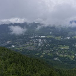
Mount Si is an 8 mile hike roundtrip in North Bend about 45 minutes east of Seattle. It is the big sibling to the smaller Little Si trail which is closeby. I missed the entrance the first time I drove by it and turned around to get to the parking lot. I arrived at 7:45am on a Friday morning and there was a good amount of parking available. It's a bigger parking lot than I expected but the potholes in the lot were a pain to drive through. The first part of the hike was mostly incline and I was dripping sweat pretty much right away. It continued like that other than the occasional flat land for like 30 seconds before it was back to incline again. There were more switchbacks near the top and was rocky to get to the very top. It was mostly cloudy on the way up and the tall trees helped shade away some of the sun as it peaked out. At the summit there were beautiful clear views of Mt. Rainier above the clouds which was just amazing to see. The contrast of the clouds and the clear skies above them were breathtaking. I fought the urge to stop and take a break multiple times on the way up and got to the top in just under 2 hours. Going down was hard on the knees with the steep decline and I got down in about 1.5 hours. It was a tough and challenging hike but I'm happy I overcame it. I recommend bringing lots of water because it can be pretty tough with all the incline. Also, there weren't too many bugs at the top but if you're bothered by them I suggest bringing some bug spray. read more


Wow! Hard to believe it's almost been a year since I moved to the PNW, this was one of my first hikes, and after the craziness of moving, charging jobs, and a few weeks without hiking, this one kicked my ass! What a year of hiking in the Cascades, and a physically and mentally challenging job can help, this time was much more enjoyable, plus knowing the terrain and area helps. It's still a kick ass hike, but much more enjoyable. The views from the peak are amazing!! Even on a cloudy getting ready to rain day, you can see Seattle, on. Clearer days Mt Rainier is viewable. Lots of fun wildlife and plant life still gearing towards fall, seeing a few trees colored up. This is a popular hike, so expect to see people, luckily parking lots is large, although full of potholes. Thank God for a 4 wheel drive, so No worries. This hike, especially as you get towards the peak, has many cross cross or zig zags on the trail, which helps, because it's steep, especially the last half mile. I didn't wear the proper shoes to rock climb, so doing the final ascent to the top of the peak will wait till next time. It still amazes me how green the foliage gets after it starts raining.. like instantly turning a more vibrant green, if that's possible? Plenty of views with out going to the top peak. And as always, since it's all uphill going to the summit, it's all downhill coming down. I would also recommend hiking poles, the help on the steep inclines and were helpful going down as the rain made some of the surfaces slick. Definitely love the sound of the rain in some of the silent moments, which brings me to one of the downsides of hiking near the I-90 corridor, still hear quite a bit of traffic noise even 6 miles away, part of the echo through the pass, but still some quiet moments. This is a challenging and fun hike, enjoy the moments, I've met lots of people who were determined to make it to the top.. and did!! Goals!! Happy hiking! SYOY , God Bless and Cheers! read more


6 years ago
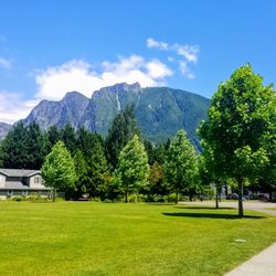
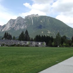
The husband and I are lucky enough to have Mount Si in our backyard and have been intending on tackling it since moving to North Bend. We finally woke up to a perfectly clear day and packed up as quickly as we could to get on the trail. There's lots of parking at the trailhead and though it started to get warm, we were shielded throughout by the beautiful canopy of trees above us. This hike is not for the faint of heart. With almost 8 miles out and back it packs a punch with its 3,188 feet elevation gain. We were mostly going up which made the few times where you get to flatten out and just enjoy the forest around you that much more sweet. At the top there's a scramble to get to the top but it's quite worth it. The view of North Bend is amazing and we enjoyed picking out our house and backyard and yelling a hello to our kitties from far above. As it was a clear day we could pick out Bellevue and the Seattle skyline to the West and Mt. Rainier to the South. There's a nice rocky peak with lots of places to sit and lunch. The wildlife is clearly quite used to human invaders and there are birds that will fly into your hand for snacks (please don't feed them junk) and cute little chipmunks and squirrels that scurry up to you to see if you might drop a small smackeral for them. You can complete your hike by climbing to the tallest point by scaling the haystack; however, we were not up for this on this particular day. The hike down was much easier and we were grateful for this as it was heating up. Overall, a lovely hike and a great workout that both the husband and I were feeling the next few days. read more


6 years ago
It's a strenuous hike. Be prepared to sweat baby, sweat. It's been on my bucket list for awhile and am finally happy to say that I've summited Mount Si. Wake up early and go! I woke up around 5:30am, arrived from Bellevue to North Bend at 6am, and there were already a handful of cars. The parking lot is larger than other trailhead parking lots around, but it gets full. It's also further down the Little Si parking lot, with signs indicating where to go. By the time I left there were cars circling around, stalking those hikers who were on their way out. Get here early, peeps! Also, be careful when you arrive to the parking lot because the gravel road was fulllll of potholes. Go slow and steady. I'd recommend driving a vehicle with AWD, as some of the potholes were really deep. Discover Pass is required. The hike is about four miles up, so eight miles roundtrip. It's strenuous in that, it's long. It especially feels like it when you're going on steeper inclines, but the trail is very well-managed. It's also much wider than other trails in the area, making it possible to socially distance from one another. The hike will have you trek through the forest much of the time, to help keep cool. There were also areas with benches where you can stop and take a break. When you're near the summit, there's a map that shows you're only 0.3 miles away from the top. There, you will end up scrambling as the area is all rock form. It's a pretty easy climb. The challenge will be for those going to Haystack Rock, which is the true summit of this hike. The views of Mount Rainier and the Snoqualmie Valley area are what you'll see first once you reach the top. But if you go back towards Haystack Rock, there's another viewpoint where you can see the Bellevue area. Many people took a break around the rocks to eat and enjoy the sights. This was an awesome hike that had my knees and feet sore! Going up was hard because it's a workout, but going down was actually harder for me because of how bad my knees and feet felt. I would recommend bringing hiking poles if you have 'em. Other than being sore the next day, it was a rewarding challenge and would recommend anyone wanting a good, long hike to check out Mount Si. read more


5 years ago
Just got back home from the hardest hike I've ever done. Started off my hike at 545am. There was already one person ahead of me and one person behind me. Definitely recommend waking up early for the hike. Discovery pass required. I ordered online but my pass never came so I just wrote down the transaction and enforcement # and placed it on my dash. I had no problems with that. Now the hike..... I started off at the Mount Si parking lot. Kept walking up very steep incline (30-45 degree it seemed like) for maybe 1 mile+ straight. Then there's a bit of downhill for a while and then more uphill climb. I don't know where I went wrong but I eventually ended up to the sign where it tells me that I have 0.3 miles to go till I reach the top. Unfortunately the snow had covered most of the trail and was very obscured. By the time I noticed that I was wandering aimlessly, following what looked like foot steps to me, I was in the middle of nowhere with no trail in sight. I WAS LOST Luckily a very nice gentleman named Chris was just 100ft from me so I yelled out for help. I climbed rocks and eventually got to where he was standing. We both attempted to find the trail to the overlook but unfortunately we both decided that it was not safe so we turned back around. If it wasn't for Chris I would have had a very difficult time even finding my way back down. On my way down I was once again hiking solo and wandered all the way to the Teneriffee parking lot. I asked the very nice couple standing by the entrance where I was and they said I was about 1 mile away from Mount Si parking lot. I nearly cried. But the nice lady, Penny drove me back and all is well. My bad knees are in pain. So confused as to how people are saying this hike is only 8 miles when I'm sure I did like 13 miles with 35,0000 steps logged on my fitness watch. If someone knew what I did please let me know lol. As someone who is a first timer hiking this particular hike and hiking it solo... I don't recommend. But I give it five stars because it was beautiful. I just wish that I could have finished the hike. read more


Came on a Saturday morning around 10AM, parking lot had many cars but lots of space, rainy cloudy day though that was forecasted to rain. Path was steadily uphill but not too steep, pretty narrow though. Thankfully not too many people on the trails. Views at the top were just okay since the rain clouds were covering a lot of the view. Having stayed up there for a bit, the clouds moved away and more of the view came out. Not too crowded at the top, and the way down was fine too. It started raining a lot more and got a bit cold. Good hike, but probably wait for good weather! read more


Beautiful hike for the able bodied. This is well worth the effort and the difficulty level is on the far end of moderate. Stunning views from the top! Parking at the trail head is ample and there is a convenient pit toilet for services. Pretty breezy above the tree line, definitely dress in layers for the transition in and out of the wood line in the colder months. Check the weather report and prepare for snowy/icy conditions for the final leg at the top during the winter. Didn't see any sign or wildlife as this trail appears to be regularly frequented. All in all, another breathtaking sight of everything to love about the PNW. read more

5 years ago
8 mile hike round trip, very rocky, bring good shoes. I'd bring two big bottles of water, views are solid but not life changing. Definitely worth doing at least once. read more

4 years ago
!!WARNING!! This hike is not for first time goes. Having said that, we had a really great time. For things to know before you go scroll down to the * Our group ranged from 18-45 y/o, with both male n females. The trek up is a workout on your legs, recommend taking a walking stick and at least 1-2 quarts of water and snacks. The trail keeps going up from the start to the top. It's a lil over 4 miles & some change up and believe me after mile 2 you really feel it, but once you hit 3.5 you can almost taste the top. Be sure to take rest breaks along the way and you'll be GTG. Our group didn't take any breaks bc we're all hard chargers, but if I was taking my fam, yeah we would have stopped n rested intermittently. Dogs are welcome, but please don't leave the poop bags on the trail. I seen a hiker with a Dodson and thought...Y you doing that to them? This is more for large to medium size dogs, small ones might injure themselves. If you take your puppers bring them water n something to eat too, they will be eternally grateful The trip down was the best feeling! Having worked so hard going up, I dang near jogged the whole way down. Some parts be careful, but you'll see the tricky steps. After all was said n done we chilled in the parking lot and enjoyed the day. *Skill lvl 4 hike, mostly incline Parking lot requires Discovery pass.(might be able to get a temp pass if ranger is there) Lots of potholes in the parking lot Don't leave valuables/electronics in cars Bring 1-2 quarts of water n snacks Walking stick recommend LRG-MED dogs, may not be suitable 4 small dogs Take breaks, and clean-up after yourself Dress in layers n bring a backpack to downgrade as needed Bathroom is only at the base n you might need a gas mask read more


11 years ago
This climb is so killer. The 4 miles in is entirely uphill and enclosed by trees, so there isn't much to focus on except for the undeniable pain in your quads that slowly starts to creep in. But, if you can get past that pain and keep moving one foot in front of the other, eventually you'll reach the top, and boy, is that view something else. It is so gratifying when you finally get to the top. It was a clear day when I went, and I could see all the way to Seattle. There was a bit more climbing to do on a rocky surface to get to a better viewing area however. That was definitely worth the climb because you got more of a 360-view with tons of photo opportunities. From this peak there was also access to higher mountain peak, but from what I gathered it was an almost vertical scaling of the mountain side with fewer safety features and many posted "caution" signs. I wouldn't say I'm scared of heights really, but extreme heights and a lack of security tends to make my palms sweaty. So I was happy staying on the lower, safer peak! After you take in the view, get your pictures in, and catch your breath, enjoy the 4-mile return trip downhill. If my college anatomy course taught me anything, though, it's the downhill portion of a hike that will make you sore the next day. :D read more


This hikes is easily accessible and just a couple minutes from the freeway exit! It was refreshing to not have to drive a whole bunch of switchbacks to get to a trailhead. From Kent, it's a quick 45 minute drive. In order to park in the lot, you have to have a discovery pass, which you can buy online and print at home for $11.50. Make sure you do this before going to the hike because there isn't a ranger there who sells the discovery pass. The hike is pretty much completely shaded the entire time except for the summit. You're surround by the beautiful Washington woods. It's a major workout! You're going uphill pretty much the entire time. You climb over 4,000 ft in elevation in just 4 miles. It took my boyfriend and 2 hours to the top and and hour and 40 minutes to the bottom. The view at the top is worth all the hard work! The birds at the summit are so cute and friendly too. They were landing on our hands and feet! read more

5 years ago
For two "hikers" this one is a must try once. We haven't hiked in at least a year and heard mixed reviews on level of difficulty. It's a constant upward hike with very few flat parts. We brought 5 bottles of water for two and went through almost all of them on the way up. It goes through mostly wooded areas with limited sun so being light layers you can shed as needed. Wear good shoes and bring snacks. Most importantly take your time and feel free to take breaks if it gets a bit much. The view at the very top is worth it. read more

12 years ago
This hike is as challenging as everyone makes it out to be. It's a steep hike, and the scenery on the way to the top is a bit boring. But once you make it to the top, you'll realize that the dud scenery and heavy panting was all worth it. At the top the view is absolutely stunning; great views of mountains and there are a lot of colorful plants as well. It's also a rock-climber's paradise. I don't have much climbing experience, but there are a lot of opportunities to climb around. I wanted to climb to the top of this one lookout point, but given that I was hiking by myself and given that I don't have much experience climbing, I didn't think it was the wisest idea. I made it about halfway up and decided to stop. I probably could've made it to the top but it was very steep and I began thinking, "I may be able to make it to the top, but how am I going to get down?" I hiked this three times last summer, once when it was foggy and twice when it was clearer. I enjoyed the hike all three times. Just make sure that you eat enough beforehand and bring enough water and snacks for the trek. read more


8 years ago
Extra star to King County for the excellent direct-to-trailhead bus service - a truly great service to the community that serves multiple goals (less traffic! easier access to hikes!). I was impressed by the number and diversity of people I saw using this service. Thanks King County! As for the trail itself, eh. Pros: The payoff was pretty fantastic, and it sure is a good workout. It's under tree cover the whole time too, so it stays a comfortable temperature. Big con: the scenery does. not. change the entire hike. 4+ hours of looking at the same thing all the way up and down. This hike is really more about the destination than the journey. I prefer hikes that hold your interest throughout. This hike is worth doing, but it's not a must-do, especially if you're looking for more than just a workout. read more


4 years ago


Round Trip: 8.0 miles Difficulty: Moderate - Difficult Discover Pass Required I started the hike on a Saturday morning. I arrived at 8 am and there were about 40 cars in the parking lot. We finished around 12:30 pm. There were a lot of people on the trail on a weekend. Morning weather started out around 60 degrees and by the time noon hit, it was 80 degrees. I wore hiking shoes, dry fit, and brought my hiking poles. My friends that came with me mentioned they wish they wore hiking shoes. The trail is mainly in the shade. The last part of the trail is steep. At the top you can get a great view of Mt Rainier on a sunny day. I highly recommend hiking poles, it is useful on the way down. The friends I went with were complaining about their knees and ended up wearing knee bands. Overall the trail is moderate to difficult. I recommend coming early to start the hike since weekends are a popular time. Good luck! read more

I came, I saw, I fought off the urge to turn back, and I eventually conquered. After hearing amazing stories from other hikers about the challenging hikes they've completed, I was inspired. Prior to this, my largest hike was up Rattlesnake Ledge. Doubling that hike length sounded like a good idea. . . . until I saw the 1.7 mile marker on Mount Si and realized that I had 2.3 miles to go. Zoiks! So many thoughts ran through my head. Should I turn back? Can I do this? Am I mentally unstable for attempting this? Fortunately the answers to those questions were No, Yes, and I don't think so. Onward bound. As I trudged up the steep hill, panting like a dog, I had to take a lot of breaks. Several groups and individuals passed me and kept going as if this was just another walk in the park for them. No worries, I'll just keep putting one. . . foot . . . in front of. . . the other. Harder than it sounds! And then I saw him - - the first guy who had passed me on the way up was now headed down. And I was no where near the summit. Damn, I didn't realize that olympic athletes climbed this mountain. But wait, there's another couple coming down that also passed me. And another. Will I ever reach the top of this frickin' mountain!?! I somehow missed all of the remaining mile markers along the way (there was one at 3 and another at 3.5) so I eventually asked someone. Turns out I "only" had about half a mile left. Summoning all of my willpower, I pushed on. And finally, the summit! When I reached the top, one of the many couples who passed me on the way up said "you made it!" It was nice to hear a cheer, especially after 3 hours of upward hiking (yes, it took me 3 hours to go those 4 miles). I was so proud of myself but my legs felt like Bambi's. After a snack, some photos, and relaxation time, I mustered up the strength to head back down. Although I don't have knee problems, this trail caused some pain through the downhill process and I cursed myself for not having hiking poles. Some steep stairs and lots of rocks contributed to that. It took me a little over 90 minutes to go down that 4 miles without stopping. So there's my adventure story. Would I do it again? Hell yeah. Next up, Mailbox Peak? read more


 :-) - Parks Near Me")


9 years ago
It took me ~2.5 hours to go up to the Snoqualmie Valley Viewpoint. ~1.5 hours to come down (running/walking). I had heard about the Haystack, but by the time I reached the Snoqualmie Valley Viewpoint, it was already 8PM, and I didn't bring a headlamp with me. Now that I know what The Haystack is though (the towering summit, not the rocky scramble that is the summit basin), I don't know if I would bother with the climb. I love heights, but the Viewpoint was satisfying enough. Be aware that there are at least two trails heading out of the basin. I almost took the wrong trail (connects to Mount Teneriffe), but I noticed that it didn't look like the trail from which I came. Late July is the wrong time for wildflowers. :( Saw some lupine that was past its peak. Side note: In terms of difficulty, I think the trail is actually more gradual then Rattlesnake. I'm not sure. It's just that you have to go twice the distance. More side notes: Discover Pass. read more


One of my favorite hikes around I-90. It's really easy to get to and it's really good workout but at the same time it will not eat up your whole day! I love this place. Usually you get to enjoy some beautiful chipmunks and birds at the top (beside the view of course!). :-) read more

11 years ago
I defeat the hike that defeated me! This was my first hike 6 years ago and I never made it past the first mile. Ever since I started hiking 5 months ago, I'm in so much better shape. My endurance has increased and my asthma has improved. I didn't find this hike as challenging as I remembered it to be. I would rate this as a moderate hike due to the many switchbacks, the steep incline in some parts and the haystack climb to the summit. This is a great hike for both novice and experience hikers. Hard enough for bragging rights but not so tough to scare people away. Difficulty: Moderate Length: 8 miles round trip Elevation Gain: 3150 ft Time: 2.5 hours up, 1 hour down Drive: Located in North Bend, exit 32 off of I-90. It's about an hour drive from Seattle. Very straightforward and easy drive. Parking: Mount Si is incredibly popular, with a huge parking lot serving the 100,000 annual visitors to this trail. I arrived around 9 am on a Saturday and the parking lot was almost filled to capacity. Two picnic tables by trail head. Outhouses available. Trail: The trail starts off quite gently through the forest. The dirt pathway is wide with a steady mild elevation gain. There are some switchbacks at this point but it is very gradual and not very clear. At 1.7 miles in, you will reach an intersection of Mount Si and Talus Loop Trail (It is clearly marked). There is also a pathway the loops around the forest. Proceed past that and continue up. From 2.3 mile is where the switchback and incline starts. This part is still consistency pretty gentle through the forest with a moderate elevation gain. Some switchbacks (I counted about 25) can get pretty long and steep. The trail is pretty well maintained with some rooty and rocky parts. To reach the summit, you need to climb the a steep rocky terrain. The summit is pretty spread out so no need to worry about space. View: Beautiful view at the top. I was able to see both Seattle and Bellevue. It was nice to see the cities from such high up with all the mountains and valleys in the background. Crowd: Very crowded trail. As I was heading down, I probably pass by more than 100 people. As I pulled out of the parking lot, there were many cars that were double parked and parked on the side of the road. *Discover Pass Required* read more


For the first 18 years of my life, I lived, like.. hmmm... 30 minutes from Mt. Si. I had never hiked it until today. A friend of mine is doing some serious hiking through the Olympia Rainforest in a few weeks and has been training w/ his 40lb pack for months now. I told him I'd like to try out Si b/c it sounded like a good time. It was a pretty intense 2 hour/ 4 mile hike up to the top. It's not straight up, and with no pack (and if you're in decent shape) it's pretty manageable. Be prepared to sweat, friends. Salt builds character. At the summit on a clear day, you can see Seattle! It was a beautiful hike. Lots of people and dogs and various marmot on the trail made it entertaining. Great scenery, great smelling, and QUIET! Make sure you wear good shoes and breathable clothing (polyester- good, cotton- bad). And PLEASE 'no jeans'.. The chaffing, Oh god.. the chaffing! Also, bring a waterbottle and a snack. The earlier you hike, the better. I suggest starting no later than 9am. It gets really busy and you want to get out of there before the crowds show up. Too tired to give any thumbs up. If I could, I'd give it two. read more

12 years ago
Until my visit to Mount Si, I thought I was in pretty good shape. Mind you, I'm not a runner or avid outdoor enthusiast, but I try to hit the elliptical a couple of days each week. I also try to walk rather than cab it when I'm downtown. So imagine my surprise when I was completely out of breath and over this hike after only 0.7 miles. Mount Si is located about 45 minutes from Seattle, towering over the nearby town of North Bend. The drive is pretty scenic and Mt Si itself was really easy to find. We went on a Sunday afternoon and the parking lot was pretty empty. Unfortunately, you need a permit to park there (which we did not have). Lucky for us, there was some limited parking on the main road for free (no permit required!). For more information on the permit, please visit: http://www.discoverpass.wa.gov/. We enjoyed a nice picnic on a bench prior to attempting this climb (key word attempt as I never made it all the way up). There are also some outhouses nearby if you need them, but I'd HIGHLY recommend finding another place to use the restroom as they fit the stereotypical mold of an outhouse (super smelly and files everywhere). The trail itself is well-maintained. It has some beautiful streams running through it and great vegetation. I found the trail really scenic. With that said, the word that should be used to describe this trail is STEEP. It is 4 miles long and 3500 feet high. I'm a novice to hiking and was way too optimistic to expect myself to make it up the trail. I am not sure what I was expecting given my husband used this trail (along with a backpack full of phone books) to train for his hike up Mount Rainier about 5 years ago. Prior to this climb, I had only hiked at the Hoh rainforest where all of the trails are ridiculously flat. In sum, this is not a hike for a novice (or for anyone who hates stairs/steep hills). If you're really into hiking and you want a great workout, then this is definitely the trail for you. You'll work up quite the sweat and burn off a ton of calories. Just make sure to bring plenty of water, snacks, and some hiking poles as it will take several hours to complete this hike. For those on my level, I would recommend climbing Little Si nearby (elevation of 1576 feet). read more

10 years ago
Do it. The hike itself is challenging but fun. Lots of good spots to rest and as long as you take your time and pace yourself you'll have no issues. Make sure you bring food with u to snack on (and refuel) at the top! The sights are amazing! So worth it! Tips: Bring food for the top! There are bathrooms at bottom of hill. Hike is steep, don't think it's a walk in the park, bring enough water. MAKE SURE YOU HAVE A DISCOVERY PASS! You can get one at the local Ace Hardware a couple miles down the main road! read more


This was a good hike that was more challenging than I had expected. We had read reviews that it was pretty tough, but doing it was definitely a good experience. At first, it doesn't seem so bad, but then you quickly realize that you're basically going uphill for the entire 4 miles. It actually seemed to increase in difficulty towards the end where you're basically climbing up stairs. However, reaching the top provides a beautiful view of Mt. Rainier and you feel so accomplished. Going down was actually fairly difficult in itself b/c the decline is pretty steep and it takes more control to walk down than to kind of trot down at times. We went on a Sunday and it wasn't as crowded as I had expected, we arrived fairly early around 9 am. However, by the time we got down (early afternoon), the parking lot was completely packed. This is a good hike if you're looking for a view and a work out. Also, they recently changed it so you now need a parking pass for hikes in WA. You can get a one time pass $10 or a yearly $30 at places like fred meyers or REI. read more


12 years ago
Mount Si is a steady 3150 foot, four mile climb to the peak. Makes for a great workout! Bring plenty of water for you and your pooch. If you have trekking poles you may want them for the trip down. I didn't use any and my knees were feeling it on mile seven. Took me 1 hr 35 min up and 1 hour down. read more


Mt Si is a very popular hike and rightly so. It is a beautiful mountain with a great network of trails that is a accessible year around. I have hiked up this mountain dozens of times and always find something new to appreciate. Visiting Mt. Si is like visiting an old friend, it just feels comfortable being together. Here are some suggestions that may help with your enjoyment as well as others . If you are looking for solitude this would not be a good choice for a summer weekend hike, or anytime for that matter. However it is much less crowded mid-week and off season. If you hike here it is polite to keep your dog on a leash and to clean up any messes they might make on the trail. read more


12 years ago
Seriously a great hike. Super challenging and your legs will be screaming the next day but the view up top is well worth it. I went with a friend on Memorial Day. We showed up at 1:30 and saw that there wasn't many people in the parking lot, which was surprising considering that it was a holiday. The hike up was difficult and I found that I only finished 1 bottle of Gatorade and some water by the time I was done. I also brought some sunflower seeds to feed the wildlife. Chipmunks loved it and they'll get super close to you to get it. The top got really chilly so I recommend packing a jacket and some gloves. Other than that. Awesome hike. read more

8 miles back and forth. Lots of switch backs. I would rate this hike a little above a moderate hike because of how steep parts of it can get. It definitely is a work out. My legs were sore for a couple of days after I have done this hike. At the top, there is a place with rocks where most of the people take their lunches. There is still a little bit more of rocky unpaved path until summit. We did not go all the way up the rocky slopes but I'm sure the view up there would be even more amazing. There are chipmunks and birds in the rest area. They are very used to people and would come to you for food. While we were sitting down and eating our sweet potato, this bird swooped down and knocked the sweet potato off of my friend's hand. it was scary how it was so bald. Definitely be aware of your stuff while up there because either the birds can swoop them away or the chipmunks will get into them. read more

5 years ago
I have to admit that I wasn't prepared for this hike. A friend found out about it and invited me to go. She knew that the hike was 4 miles each way, but what she didn't know was the over 3,000 ft elevation gain. When pulling into the parking lot in November we were surprised to see it was packed with cars, this is obviously a popular hike, so keep that in mind if you are like me and take your dog hiking with you. The policy is that dogs should be leashed. Personally, I feel it should be unruly dogs should be leashed, not good dogs like mine. Anyway, the hike itself is pretty much straight up. There are a couple points where it levels off and a rest area just under halfway up. At the top there is a high peak that I'm surprised is actually open to hikers. In this day and age, I'd expect someone to slip and fall on the jagged rocks, break a hip, and sue the forest service, resulting in the place being closed down. But luckily it is open and if it weren't completely surrounded by clouds on the day I went, I'd imagine it's a spectacular view. This hike is definitely for the serious hikers. And I would highly recommend bringing lots of water and some food. I don't think you need the walking poles that I saw quite a few people utilizing, as the trail itself is pretty clear and open. You might need them at the top, or you could just pay attention to where you are stepping. I am going to give this hike 4 instead of 5 stars though. The primary reason is, when I go hiking I prefer to get away from people, not go the places everyone else is. This hike was pretty busy in November; I could only imagine what it's like in the summer. I'm also giving 4 stars because of the leash rule. Most people we passed with dogs let their dogs off the leash for a while, and so did I. And most people we passed who didn't have dogs were pretty cool about my dog not being on a leash, which was nice. read more


11 years ago
Oh, Mount Si. This hike was definitely a win-lose for me. Win = the view at the top. I heard a woman say "this is heaven" and it really was the day we were there. We were up above a thick layer of soft clouds and had an amazing view of Mt Rainier while we were eating our lunch. It was such a reward for all of the hard work we put in to get to the top. There literally was a bird that landing on some guy's hand - it was like a Disney movie or something - I was expecting the bird to bust out in song. Lose = anyone with bad knees knows it's not the climb up that kills you, it's the climb down. And with a climb this steep, the way down hurt SO bad. I didn't have my hiking poles at the time, and I needed them for sure. My knees hurt for a week, which is impressive. So, it was definitely a one time thing for me, but I recommend it at least once - if only for the view at the top :) read more

10 years ago
I'm from Texas and just moved here. This was my first hike up a mountain and my first hike in ice/snow. It was not fun, to say the least. I'm not in awful shape. I average about 35 miles a week running, but that's it as far as working out. This was definitely a harder workout than any of my runs. I hiked in January, and I highly recommend yaktraks. It was a very slow climb without them. The slipping and sliding definitely effected time. It took us 3 hours up and 1.5 down. I just had hiking boots and no trekking poles (yes, I'm an idiot). I couldn't wait to reach the top to come back down but turns out coming down was even worse. I fell on my ass at least 5 times. (And I wasn't the only person falling). And I think after all the hard work going up, I was kinda let down by the view. Plus it was freezing. Perhaps I'm just not cut out for hiking. I'm glad I did it but probably won't go back. I recommend this hike when there is no snow or get yaktraks. Good workout nonetheless! read more


14 years ago
After hiking four miles up, sitting atop this mountain on a clear day and enjoying the many spectacular views is hard to beat. It's also a great reward, because reaching the top is a feat in itself. If you haven't been working out your legs much expect to be sore within the next couple of days. You're literally going to be hiking up the entire time and reaching an elevation well over 2,000 feet. The first time I did this hike my legs were sore by the time I was halfway back down! This is definitely one of my favorite day hikes and quick escapes out of the city and into nature. Even though the trail does get crowded on nice days I enjoy just being away from Seattle for awhile and hanging out on the mountain. It's difficult but doable, and it's a great hike to train your legs and get your cardio on. Running down the mountain gives me this fantastic rush that has me addicted to Mount Si (partially from the danger and partially from the run itself), and the thought of being able to run all the way up keeps me motivated to come back and improve my stamina on the mountain. Some Advice: + Bring plenty of water on a hot/warm day (at LEAST a couple liters) and start out well hydrated (I learned this the hard way). + If you're not wanting a snack during the hike up you'll likely want one once you reach the top, so bring some good food to munch on. + WEAR GOOD SHOES FOR HIKING (also learned this the hard way) and watch your step! + Bring a camera + I most recently came here on Super Bowl Sunday and the entire last mile of the hike to the top was covered in snow. Not so bad going up, but a slip and slide pain coming down. Be prepared for it in the winter months. read more


This was the first hike I have ever done. I was really worried that I wouldn't be in good enough shape to conquer this one. Surprisingly, I did it! The hike itself was beautiful...you get really in touch with the nature. However, if you are expecting a view throughout the hike, then you'd be disappointed. You don't really get a good view until you get towards the top. Overall, this is a great hike and you wouldn't be disappointed if what you want from it is a good work out. Personally, I like to hike at places with beautiful and different views when I get to the very top so that I can look back and let nature take my breath away. Maybe I just got to give this place another chance... but there are so many other hikes I'd like to try first. read more

17 years ago
Page 1 of 3
More info about Mount Si
North Bend, WA 98045
Directions
(360) 825-1631
Call Now
Visit Website
http://www.wta.org/go-hiking/hikes/mount-si
Hours
Indoor Amenities
Outdoor Amenities
Ask the Community - Mount Si
Review Highlights - Mount Si


Why does Yelp recommend reviews?
Mount Si - parks - Updated June 2026
Best of North Bend
People found Mount Si by searching for…
Hiking Trails With Waterfalls in North Bend, Washington
Scenic Drive in North Bend, Washington
Campgrounds in North Bend, Washington
Dog Parks in North Bend, Washington
Places to Take Pictures in North Bend, Washington
Things to Do in North Bend, Washington
Stairs Workout in North Bend, Washington
Scenic View in North Bend, Washington
Photo Spots in North Bend, Washington
Rock Climbing in North Bend, Washington
Playgrounds in North Bend, Washington
Parks With Pull Up Bars in North Bend, Washington
Scenic Spots in North Bend, Washington
Picnic Areas in North Bend, Washington
Waterfalls and Swimming Holes in North Bend, Washington
Fishing Spots in North Bend, Washington
Easy Hikes in North Bend, Washington
Secret Spots in North Bend, Washington
Tennis in North Bend, Washington
River Swimming in North Bend, Washington
Stair Climbing in North Bend, Washington
Natural Hot Springs in North Bend, Washington
Trending Searches in North Bend, WA
Black Owned Nail Salons near Mount Si
Dog Friendly Beaches near Mount Si
Dog Friendly Trails near Mount Si
Free Picnic Areas near Mount Si
Kids Activities Outdoor near Mount Si
Outdoor Activities near Mount Si
Outdoor Basketball Courts near Mount Si
Paddle Boat Rentals near Mount Si
Places To Walk Around near Mount Si
Sand Volleyball Courts near Mount Si
Scenic Night View near Mount Si
Browse Nearby
BEST of North Bend, Washington Restaurants near Mount Si
BEST of North Bend, Washington Coffee near Mount Si
BEST of North Bend, Washington Things to Do near Mount Si
BEST of North Bend, Washington Playgrounds near Mount Si
BEST of North Bend, Washington Breakfast near Mount Si
BEST of North Bend, Washington Picnic Areas near Mount Si
BEST of North Bend, Washington Campgrounds near Mount Si
Browse Brands
Related Searches in North Bend, WA
Affordable Kayak Rental Services in North Bend, Washington
Best Fishing Locations and Guides in North Bend, Washington
Best Nature Trails for Hiking in North Bend, Washington
Best Off Leash Dog Parks in North Bend, Washington
Best Parks for Parties and Events in North Bend, Washington
Best Places for Horseback Riding in North Bend, Washington
Best Water Parks for Kids in North Bend, Washington
Check Out Great Playgrounds in North Bend, Washington
Check Out Off Road Trails in North Bend, Washington
Discover Baseball Fields Around North Bend, Washington
Discover Beautiful Garden Spots in North Bend, Washington
Discover Dog Friendly Trails to Explore in North Bend, Washington
Discover Fun Toddler Parks in North Bend, Washington for Your Little One
Discover Lakes & Ponds to Explore in North Bend, Washington
Discover Popular Photo Spots in North Bend, Washington
Discover Scenic Mountain Bike Trails Near North Bend, Washington
Discover Scenic Waterfall Spots in North Bend, Washington
Discover Soccer Fields in North Bend, Washington Near You
Discover Top Nature Parks to Visit in North Bend, Washington
Discover Top State Parks to Visit in North Bend, Washington
Discover Walking Parks in North Bend, Washington Near You
Discover a Hiking Trail in North Bend, Washington
Discover the Best Beaches in North Bend, Washington
Discover the Best Kids Park Spots in North Bend, Washington
Discover the Best Night Hike Trails in North Bend, Washington
Dog-Friendly Hikes With Dogs in North Bend, Washington
Enjoy Camping Adventures Around North Bend, Washington
Enjoy Exciting Mountain Biking Adventures in North Bend, Washington
Enjoy Kayaking Adventures in North Bend, Washington
Enjoy Tent Camping Spots Around North Bend, Washington
Enjoy a Beautiful Waterfall Hike in North Bend, Washington
Enjoy the Best Picnic Spots and Ideas in North Bend, Washington
Enjoy the Best Walking Path in North Bend, Washington
Enjoy the Best Walking Trails in North Bend, Washington
Experience Thrilling White Water Rafting in North Bend, Washington
Explore Beautiful Botanical Gardens in North Bend, Washington
Explore Beautiful Parks and Green Spaces in North Bend, Washington
Explore Easy Hikes Perfect for All in North Bend, Washington
Explore Family-Friendly Zoos and Wildlife in North Bend, Washington
Explore Free Picnic Areas Around North Bend, Washington
Explore Fun Activities to Do in North Bend, Washington
Explore Parks With Pull Up Bars in North Bend, Washington
Explore Popular Campgrounds Near North Bend, Washington
Explore Popular Picnic Areas Around North Bend, Washington
Explore Popular RV Parks Around North Bend, Washington
Explore Scenic Lakes to Visit in North Bend, Washington
Explore Top Dog Parks in North Bend, Washington Near You
Explore Top Water Parks in North Bend, Washington Today
Explore the Best Beach Spots in North Bend, Washington
Explore the Best Swimming Holes Around North Bend, Washington
Browse Articles
People who viewed Mount Si also viewed
Lake Serene Peak
6 reviews
Cherry Creek Falls Trail
43 reviews
Bandera Mountain
13 reviews
Twin Falls Trailhead
143 reviews
Paradise Valley Recreation Area
3 reviews
Poo Poo Point - Chirico Trail
166 reviews
Little Si
107 reviews
Weeks Falls Interpretive Trail
5 reviews
Bridle Trails State Park
40 reviews
Big Creek Falls - Taylor River Trail
3 reviews