Denny Creek Photos


You might also consider
More like Denny Creek
Recommended Reviews - Denny Creek
Start your review...

Reviews With Photos

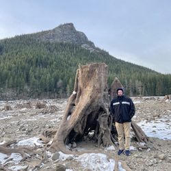
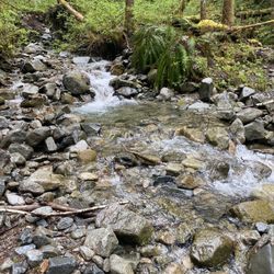
On paper, Melakwa is my idea of the perfect hike...an Alpine Lakes trail switchbacking up to a picturesque lake. Late summer and early fall is the best time to hit Melakwa - snow from the previous winter is pretty much all melted - so creeks and streams are running low, and weather is at its best. Melakwa Lake is a beautiful lake adjacent to massive diagonal talus (rock) slopes sweeping out from Chair Peak. Campfires are a no-no at the lake and camping, while not banned, is discouraged. The hike up to the lake affords views of two waterfalls plus peeks into very steep canyons. For Puget Sounders, this is an easily accessible hike. Take Exit 47 (Denny Creek) from I-90 and cross over to the north side of the interstate. Immediately take a right at the T in the road. Follow the signs to Denny Creek Campground (about 3 miles). Parking is fairly ample at the trail head. You do need a U.S. Forest Service parking permit to park in the lot next to the trail head. You also need to fill out a wilderness permit and drop the bottom half of the permit into the box at the trailhead. The Mountaineer Alpine Lakes book (at least the somewhat creaky 90's edition I possess) understates the time it takes to complete the Melawka hike; they say it takes 6 hours. That's wishful thinking. Even though I can assure you that we weren't lollygagging, it took 3 ¾ hours to make it to the top (plus time for lunch by the lake and taking little breaks along the way), then 2 ¾ hours to go back down. To put the intensity of the Melakwa Lake hike into Fitbit terms: I logged 302 flights of stairs and 33,500 steps. The round trip is at least 11 miles and the elevation gain is 2,600', which is going to ensure that you are stiff the next day if you haven't hiked in a while. On the climb up, you hit Hemlock Pass (elev. 4,600'). The trail then sidles along the ridge for about 1/2 mile, even descending a bit before you finally get to the lake. Be careful on your way back down to the Denny Creek trailhead that you do not succumb to the temptation to follow a trail that immediately drops off from Melakwa Lake. This trail heads to Pratt Lake and people have gotten lost making that mistake. I might as well tell you this, because most hike books do not, most of the Melakwa Lake trail (at least 75%) is over rocky talus fields, making for a slow expedition, with you having to micromanage every step.

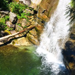
What a fun and easy breezy hike. It felt more like a nature walk with a 700 ft elevation. 4 mile round trip -- kid & elderly friendly. At the top of the trail there's a rocky area where lots of families set up camp & picnic while their kids go down the "natural water slide". Pack towels if you decide to play in the water. Forest pass required -- this is totally different from federal & and state discovery pass! OMG you're better off using the woods for a #1 if you need to use the bathroom. The bathroom was beyond disgusting and I held my breath! OMG OMG OMG OMG. You get the picture? Lots of bugs! Darn horse flies. They were swarming me. They bite too! I found my bug repellent bracelet was effective. The bug spray seemed to attract them more! Go figure.

For people who don't hike a lot, this is a do-able but challenging hike. The climb from the parking lot to the lake is 1,820 feet (equal to about 150-180 flights of stairs). It's pretty far (9 miles round trip) and can take up most of the day. My group started during lunch time and finished passed dinner time, but this duration takes into account of our picture taking and stops to relax at stopping points. And yes, you can do it! This trail gives hikers a combination of flats, rocky floors, lots of uneven surfaces, small easy climbs, few wet surfaces, quietness, view of water fall, and rewarding view of lake. Some parts of the trail are shaded while others are in the sun. Be prepared! Don't underestimate this hike! IMPORTANT TIPS: -Bring a small day pack that is light weight and comfortable to carry all the items listed on the next bullet points. -Bring at least 2 Liters of water, especially on a hot day. This is very important. Some people can get away with 1 Liter but you'll be dehydrated on your way back. -Use sun screen on face, neck, arms, etc. -Bring snacks, fruits, or nuts. -Do not litter. Let others enjoy this park the same way you can enjoy it. -Watch out for pot holes in the parking lot. Our Honda Fit was able to maneuver through though. -Bring walking/hiking sticks. This will really help!!! -Don't bother tracking your hike using GPS. You'll lose signal eventually. -Bring a first aid kit just in case. -Wear proper hiking shoes. I really like my boot because it provided lots of grip and prevented ankle rolling. -Sign the paperwork at the posted sign before entering. -Make sure you get the proper parking pass and hang it on your car before leaving.

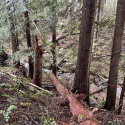
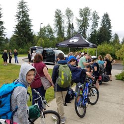
Definitely check out the Washington Trails Association site for reviews on this hike. It's basically Yelp for the hiking world (aka awesome.) http://www.wta.org/go-hiking/hikes/denny-creek But my un-athletic ass is not a hiker and so my review shall be placed here. As a skinny-fat resident of the Great Pacific Northwest I have an obligation to love hiking. Enjoying the beautiful nature and fresh air while strolling along the trails is what summer is all about! ...Yet I almost died on this hike. It started on a weekday in early August of 2011 when myself and two friends departed Bellevue for the hour drive to the Denny Creek trail head. For a weekday, it was fairly crowded with ~15 ish cars in the parking lot. You were supposed to have some park pass, but we stopped multiple places on the way and couldn't find where to buy one. So we just said "fuck it" and took our chances. It sucked though because we were more than willing to pay to park, it's just not convenient in any way, shape, or form to get a pass when you can't buy it there. The hike took us most of the day, and I brought up the rear the entire way. Despite the crowds in the parking lot, most people seemed to stop at the rock-water-slide things and we only passed a few other people on the way to the lake. It was a very pretty hike with water falls, trees, and meadows. There were a few tricky parts where we lost the trail a bit and some fallen trees to hop, but we made it. The lake was large and gorgeous and there was still a little snow in spots. My out of shape body found it to be quite an exhausting hike, but my party members found it more enjoyable. And one hiking freak actually RAN past us up the hill. Overall it's really pretty, not overly crowded, and a good time! I'd definitely go back.

The other day my man and I took an hour drive from tacoma here. We did a hike here but were looking for franklin falls instead we did a long and medium hard hike with 51 flights going by my fitbit... it lead us to denny creeks natrual water slides... they were awesome only wish we had came to get wet we had no towels so instead we just enjoyed watching all the other familys in the water having a blast. The hike was a 1 mile length. But it felt like 2. The hike up was hard on my legs but I seen elderly doing it happily so whatever that means for me. Im out of shape. Lol. I enjoyed myself tho, and recommend it to anybody whos looking to work those calves. My dog loved it to he was a trooper.

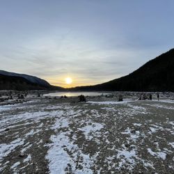
Can't believe no one has reviewed this hike yet! It's another popular one off of I-90, easily accessible. In the summer, it's a great one for kids because you reach a natural "waterslide" on smooth rocks pretty early on. Past that, there are a few waterfalls, Keekwulee Falls being the prettiest. This is a pretty good turnaround spot for the novices. If you keep going, there's a nice valley full of flowers in the summer. Another good turnaround spot because after that, you head upwards to Hemlock Pass and finally to Melakwa Lake. Melakwa's a pretty lake, not that large, and there are campsites. In fact, the camping might not be a bad way to go because 10 miles makes for a pretty long day hike.

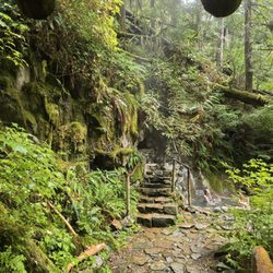
I really liked Denny Creek Trail! I had a very pleasant hiking experience going through the lush green trees and inhaling the fresh air of Snoqualmie, which was a nice break from the polluted and stuffy air in CA where I'm from. The trail wasn't very challenging, especially if little kids can complete it too. It was unexpectedly a long trail with a lot of mosquitoes hovering over my face and my legs. The mosquitoes don't really bite unless they're attracted to the scent of your skin applications other than bug repellents. What I enjoyed most about this trail was the scenery and the different kinds of paths it entailed, including wooded steps, plain dirt,bridges, rock steps, etc. You'll never get bored during this hike because the surfaces change every few feet. The ultimate reward was the water slide, which was breathtaking as it was surrounded by tall trees in every direction. Kids and adults relaxed under the shades here and some of course went in the chilling water to cool down. This was such a fun exercise that I would do it over and over again. The atmosphere in Snoqualmie was wonderful. Even though it was warm the day I hiked, there were still nice breezes and it's never hot enough to dehydrate me like it would in CA.

Denny Creek Waterslide 4/16 Easy hike through the snow along crystal clear waters. So many views to see along the way to the slide. You will want micro spikes but it is doable without. You are unable to park directly at the trailhead so you must walk the access road to the trail head which adds less than a mile extra round trip. 3.09 miles, 577 ft elevation gain, and 1 hr 20 minutes to complete. read more


3 years ago
Beautiful ! Cute hiking trail and scenery, definitely coming back soon! The weather was perfect and drive wasn't too far from where we were from. read more

Nice moderate trail starting from Denny Creek Campground. The first stint that gets to the big rocks with natural slides and pools is easy to moderate and family friendly. From there it gets a bit more challenging, but still doable, even for small kids in a good mood . I only got up to the Keekwulee Falls, so I can't comment beyond that point. Up to there it was a quite nice hike, with great views and lots of nature. In the first part you pass below I-90 which is noisy as hell and kind of ruins the whole nature vibe, but then you walk a not more and the noise fades away. It's super close to the Bellevue/Issaquah/Sammamish area, less than an hour drive, so if you live around there it's super convenient for a day trip. In the weekend parking can get crazy or impossible, so watch out. read more


On paper, Melakwa is my idea of the perfect hike...an Alpine Lakes trail switchbacking up to a picturesque lake. Late summer and early fall is the best time to hit Melakwa - snow from the previous winter is pretty much all melted - so creeks and streams are running low, and weather is at its best. Melakwa Lake is a beautiful lake adjacent to massive diagonal talus (rock) slopes sweeping out from Chair Peak. Campfires are a no-no at the lake and camping, while not banned, is discouraged. The hike up to the lake affords views of two waterfalls plus peeks into very steep canyons. For Puget Sounders, this is an easily accessible hike. Take Exit 47 (Denny Creek) from I-90 and cross over to the north side of the interstate. Immediately take a right at the T in the road. Follow the signs to Denny Creek Campground (about 3 miles). Parking is fairly ample at the trail head. You do need a U.S. Forest Service parking permit to park in the lot next to the trail head. You also need to fill out a wilderness permit and drop the bottom half of the permit into the box at the trailhead. The Mountaineer Alpine Lakes book (at least the somewhat creaky 90's edition I possess) understates the time it takes to complete the Melawka hike; they say it takes 6 hours. That's wishful thinking. Even though I can assure you that we weren't lollygagging, it took 3 ¾ hours to make it to the top (plus time for lunch by the lake and taking little breaks along the way), then 2 ¾ hours to go back down. To put the intensity of the Melakwa Lake hike into Fitbit terms: I logged 302 flights of stairs and 33,500 steps. The round trip is at least 11 miles and the elevation gain is 2,600', which is going to ensure that you are stiff the next day if you haven't hiked in a while. On the climb up, you hit Hemlock Pass (elev. 4,600'). The trail then sidles along the ridge for about 1/2 mile, even descending a bit before you finally get to the lake. Be careful on your way back down to the Denny Creek trailhead that you do not succumb to the temptation to follow a trail that immediately drops off from Melakwa Lake. This trail heads to Pratt Lake and people have gotten lost making that mistake. I might as well tell you this, because most hike books do not, most of the Melakwa Lake trail (at least 75%) is over rocky talus fields, making for a slow expedition, with you having to micromanage every step. read more


What a fun and easy breezy hike. It felt more like a nature walk with a 700 ft elevation. 4 mile round trip -- kid & elderly friendly. At the top of the trail there's a rocky area where lots of families set up camp & picnic while their kids go down the "natural water slide". Pack towels if you decide to play in the water. Forest pass required -- this is totally different from federal & and state discovery pass! OMG you're better off using the woods for a #1 if you need to use the bathroom. The bathroom was beyond disgusting and I held my breath! OMG OMG OMG OMG. You get the picture? Lots of bugs! Darn horse flies. They were swarming me. They bite too! I found my bug repellent bracelet was effective. The bug spray seemed to attract them more! Go figure. read more

For people who don't hike a lot, this is a do-able but challenging hike. The climb from the parking lot to the lake is 1,820 feet (equal to about 150-180 flights of stairs). It's pretty far (9 miles round trip) and can take up most of the day. My group started during lunch time and finished passed dinner time, but this duration takes into account of our picture taking and stops to relax at stopping points. And yes, you can do it! This trail gives hikers a combination of flats, rocky floors, lots of uneven surfaces, small easy climbs, few wet surfaces, quietness, view of water fall, and rewarding view of lake. Some parts of the trail are shaded while others are in the sun. Be prepared! Don't underestimate this hike! IMPORTANT TIPS: -Bring a small day pack that is light weight and comfortable to carry all the items listed on the next bullet points. -Bring at least 2 Liters of water, especially on a hot day. This is very important. Some people can get away with 1 Liter but you'll be dehydrated on your way back. -Use sun screen on face, neck, arms, etc. -Bring snacks, fruits, or nuts. -Do not litter. Let others enjoy this park the same way you can enjoy it. -Watch out for pot holes in the parking lot. Our Honda Fit was able to maneuver through though. -Bring walking/hiking sticks. This will really help!!! -Don't bother tracking your hike using GPS. You'll lose signal eventually. -Bring a first aid kit just in case. -Wear proper hiking shoes. I really like my boot because it provided lots of grip and prevented ankle rolling. -Sign the paperwork at the posted sign before entering. -Make sure you get the proper parking pass and hang it on your car before leaving. read more


14 years ago
Definitely check out the Washington Trails Association site for reviews on this hike. It's basically Yelp for the hiking world (aka awesome.) http://www.wta.org/go-hiking/hikes/denny-creek But my un-athletic ass is not a hiker and so my review shall be placed here. As a skinny-fat resident of the Great Pacific Northwest I have an obligation to love hiking. Enjoying the beautiful nature and fresh air while strolling along the trails is what summer is all about! ...Yet I almost died on this hike. It started on a weekday in early August of 2011 when myself and two friends departed Bellevue for the hour drive to the Denny Creek trail head. For a weekday, it was fairly crowded with ~15 ish cars in the parking lot. You were supposed to have some park pass, but we stopped multiple places on the way and couldn't find where to buy one. So we just said "fuck it" and took our chances. It sucked though because we were more than willing to pay to park, it's just not convenient in any way, shape, or form to get a pass when you can't buy it there. The hike took us most of the day, and I brought up the rear the entire way. Despite the crowds in the parking lot, most people seemed to stop at the rock-water-slide things and we only passed a few other people on the way to the lake. It was a very pretty hike with water falls, trees, and meadows. There were a few tricky parts where we lost the trail a bit and some fallen trees to hop, but we made it. The lake was large and gorgeous and there was still a little snow in spots. My out of shape body found it to be quite an exhausting hike, but my party members found it more enjoyable. And one hiking freak actually RAN past us up the hill. Overall it's really pretty, not overly crowded, and a good time! I'd definitely go back. read more


The other day my man and I took an hour drive from tacoma here. We did a hike here but were looking for franklin falls instead we did a long and medium hard hike with 51 flights going by my fitbit... it lead us to denny creeks natrual water slides... they were awesome only wish we had came to get wet we had no towels so instead we just enjoyed watching all the other familys in the water having a blast. The hike was a 1 mile length. But it felt like 2. The hike up was hard on my legs but I seen elderly doing it happily so whatever that means for me. Im out of shape. Lol. I enjoyed myself tho, and recommend it to anybody whos looking to work those calves. My dog loved it to he was a trooper. read more


Can't believe no one has reviewed this hike yet! It's another popular one off of I-90, easily accessible. In the summer, it's a great one for kids because you reach a natural "waterslide" on smooth rocks pretty early on. Past that, there are a few waterfalls, Keekwulee Falls being the prettiest. This is a pretty good turnaround spot for the novices. If you keep going, there's a nice valley full of flowers in the summer. Another good turnaround spot because after that, you head upwards to Hemlock Pass and finally to Melakwa Lake. Melakwa's a pretty lake, not that large, and there are campsites. In fact, the camping might not be a bad way to go because 10 miles makes for a pretty long day hike. read more


13 years ago
I really liked Denny Creek Trail! I had a very pleasant hiking experience going through the lush green trees and inhaling the fresh air of Snoqualmie, which was a nice break from the polluted and stuffy air in CA where I'm from. The trail wasn't very challenging, especially if little kids can complete it too. It was unexpectedly a long trail with a lot of mosquitoes hovering over my face and my legs. The mosquitoes don't really bite unless they're attracted to the scent of your skin applications other than bug repellents. What I enjoyed most about this trail was the scenery and the different kinds of paths it entailed, including wooded steps, plain dirt,bridges, rock steps, etc. You'll never get bored during this hike because the surfaces change every few feet. The ultimate reward was the water slide, which was breathtaking as it was surrounded by tall trees in every direction. Kids and adults relaxed under the shades here and some of course went in the chilling water to cool down. This was such a fun exercise that I would do it over and over again. The atmosphere in Snoqualmie was wonderful. Even though it was warm the day I hiked, there were still nice breezes and it's never hot enough to dehydrate me like it would in CA. read more


9 years ago
Take bug spray! They were aggressive at the Creek. Beautiful but too many bugs. To get to it, pass the Franklin Falls trail and over the bridge. Parking is limited. Pass required is, Northwest Forest pass or $5 Day use. There is a pay station at the Trail entrance. Also accepted are, Interagency Annual Pass, Interagency Access Pass, etc.... I've added a photo of the passes accepted. read more


11 years ago
12 years ago
10 years ago
More info about Denny Creek
Fs 5830
North Bend, WA 98045
Directions
Visit Website
http://www.wta.org/go-hiking/hikes/denny-creek
Hours
Outdoor Amenities
Other Amenities
Ask the Community - Denny Creek
Review Highlights - Denny Creek
You might also consider


Why does Yelp recommend reviews?
1 review that is not currently recommended
The reviews below are not factored into the business's overall star rating.
11 years ago
Denny Creek - hiking - Updated July 2026
Best of North Bend
People found Denny Creek by searching for…
Hiking Trails With Waterfalls in North Bend, WA
Waterfalls and Swimming Holes in North Bend, WA
Things to Do in North Bend, WA
Places to Take Pictures in North Bend, WA
Long Term Rv Parking in North Bend, WA
Picnic Areas in North Bend, WA
Camping Sites in North Bend, WA
Tent Camping in North Bend, WA
Flower Fields in North Bend, WA
Hiking With Kids in North Bend, WA
Picnic Spots in North Bend, WA
River Swimming in North Bend, WA
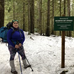
Natural Hot Springs in North Bend, WA
Water Parks for Kids in North Bend, WA
Trending Searches in North Bend, WA
Black Owned Nail Salons near Denny Creek
Cliff Jumping near Denny Creek
Crabbing Location near Denny Creek
Jet Ski Rental near Denny Creek
Lakes & Ponds near Denny Creek
Long Term Rv Parking near Denny Creek
Off Road Trails near Denny Creek
Outdoor Activities near Denny Creek
Places To Swim near Denny Creek
Places To Walk Around near Denny Creek
Pool Day Pass near Denny Creek
Public Shower near Denny Creek
River Swimming near Denny Creek
Running Trails near Denny Creek
Rv Campgrounds near Denny Creek
Scenic Night View near Denny Creek
Scenic Overlook near Denny Creek
Swimming Holes near Denny Creek
Browse Nearby
Browse Brands
Related Cost Guides
Related Searches in North Bend, WA
Affordable Kayak Rental Services in North Bend, Washington
Affordable Long Term RV Parking in North Bend, Washington
Best Day Camps for Children in North Bend, Washington
Best Fishing Locations and Guides in North Bend, Washington
Best Nature Trails for Hiking in North Bend, Washington
Best Places for Horseback Riding in North Bend, Washington
Best Summer Camps for Kids Located in North Bend, Washington
Browse Charming Cabins in North Bend, Washington
Browse Top Hotels in North Bend, Washington for Your Stay
Browse Vacation Rentals to Book in North Bend, Washington
Check Out Off Road Trails in North Bend, Washington
Discover Dog Friendly Trails to Explore in North Bend, Washington
Discover Free Campgrounds in North Bend, Washington Area
Discover Scenic Beach Camping Sites in North Bend, Washington
Discover Scenic Mountain Bike Trails Near North Bend, Washington
Discover Scenic Waterfall Spots in North Bend, Washington
Discover Top Nature Parks to Visit in North Bend, Washington
Discover Top State Parks to Visit in North Bend, Washington
Discover Walking Parks in North Bend, Washington Near You
Discover a Hiking Trail in North Bend, Washington
Discover the Best Beaches in North Bend, Washington
Discover the Best Night Hike Trails in North Bend, Washington
Dog-Friendly Hikes With Dogs in North Bend, Washington
Enjoy Camping Adventures Around North Bend, Washington
Enjoy Exciting Mountain Biking Adventures in North Bend, Washington
Enjoy Hiking Adventures in North Bend, Washington
Enjoy Kayaking Adventures in North Bend, Washington
Enjoy RV Camping Adventures in North Bend, Washington
Enjoy Tent Camping Spots Around North Bend, Washington
Enjoy a Beautiful Waterfall Hike in North Bend, Washington
Enjoy the Best Picnic Spots and Ideas in North Bend, Washington
Enjoy the Best Walking Path in North Bend, Washington
Enjoy the Best Walking Trails in North Bend, Washington
Experience Thrilling White Water Rafting in North Bend, Washington
Explore Beautiful Parks and Green Spaces in North Bend, Washington
Explore Easy Hikes Perfect for All in North Bend, Washington
Explore Fun Activities to Do in North Bend, Washington
Explore Mobile Home Parks in North Bend, Washington Now
Explore Popular Campgrounds Near North Bend, Washington
Explore Popular Picnic Areas Around North Bend, Washington
Explore Scenic Lakes to Visit in North Bend, Washington
Explore Summer Camps for All Ages in North Bend, Washington
Explore Top Dog Parks in North Bend, Washington Near You
Explore Top Tent Campgrounds Near North Bend, Washington
Explore Top Water Parks in North Bend, Washington Today
Explore the Best Beach Spots in North Bend, Washington
Explore the Best Swimming Holes Around North Bend, Washington
Explore the Best Trail Options in North Bend, Washington
Browse Articles
People who viewed Denny Creek also viewed
Franklin Falls Trailhead
142 reviews
Bandera Mountain
13 reviews
Weeks Falls Interpretive Trail
5 reviews
Denny Creek Campground
15 reviews
Snoqualmie Point Park
18 reviews
Little Si
107 reviews
Big Creek Falls - Taylor River Trail
3 reviews
Dirty Harry's Balcony
10 reviews
Lake Kachess Campground
46 reviews
Kendall Katwalk
4 reviews