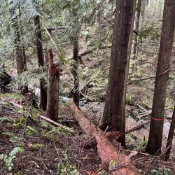
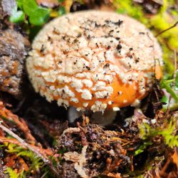
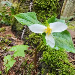
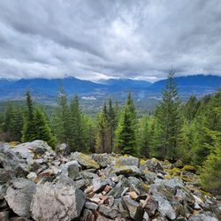
Cedar Butte Trail Photos


More like Cedar Butte Trail
Recommended Reviews - Cedar Butte Trail
Start your review...

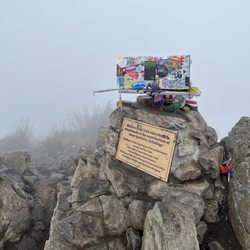
Came here on Memorial Day Monday, didn't quite see the fork off of Iron Horse Trail so ended up doing Olallie and came on Cedar Butte on the way back. Got to the parking lot around 7AM, not many cars but saw many people on the way down from Cedar Butte. The view at the top of Cedar Butte was just okay, there was a small clearing between trees to see the view but otherwise can't really see anything. read more


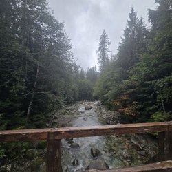
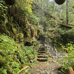
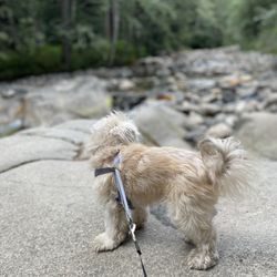
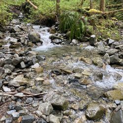
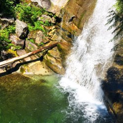
Such a hidden gem! I agree with the previous reviews, it was quite hard to find/navigate. There is absolutely no signage for "Cedar Butte" but we were able to figure it out by asking people where they were coming from. That is the only reason for 4 stars, plus the bugs. I was surprised it was so buggy for a hot summer day in the 70's. It's in the middle of the forest though. The hike took us only 2 hours to complete, with a few stops and a small pup who hates to walk. It was very easy up until the trail leading into the forest. That was a bit more moderate, except it was easy since it was only for about 30-40 minutes of incline. The viewpoint is small, and only one group can have an optimal view with social distancing. However the trail is definitely a hidden gem and has less traffic. Overall I think it was a beautiful, easy and quick hike! I wanted to share some helpful directions to help navigate: Parking - The Rattlesnake ledge lot leading up to it is packed, but luckily this has a bit more space. Plug "47.43246, -121.76654" into your GPS and it'll take you directly to the Cedar Butte lot. When I had input "Cedar Butte Trailhead" into my GPS originally it took me elsewhere. After you park and head to the trailhead you'll see a sign for Iron horse trail. Head that way by taking that first right. You'll come to a clearing with a dirt road, look straight and you'll see a narrow path to follow. It'll bring you to another clearing of a dirty road then make a left. Walk until you see a waterfall/river and cross that bridge. Quickly after make your first right up the narrow path. Eventually you'll come to a fork, take a left. Then you'll eventually see signage for the summit. Follow that and you'll be there in the next 10 minutes! read more


This was my first real Washington hike, and I agree with Lauren P. that the WTA description was very helpful in finding this trail. As a beginning hiker who is trying to get in shape, I usually choose easy hikes because I never know just how "easy" they really will be. And this is the reason. For an experienced hiker, or a pretty fit person, this might be considered easy. But this hike was quite challenging for me due to the constant (although not very steep) incline. I would call this more moderate just due to the steady incline. I also took the summit trail, and was so relieved when we reached the top! The view is quite nice. The viewpoint is small, but there was no one up there when we arrived so that wasn't an issue. I liked this trail because it wasn't very crowded. We passed a few groups on the way up and a few on the way down, but most of the time had the trail to ourselves. We arrived at about 11:30am and passed Rattlesnake, which was insanely packed. The lot for the Iron Horse State Park, where you park for the Cedar Butte Trail, was virtually empty. You do need a discover pass to park there, which I think is totally worth it at $30/year. My tracker told me this was just over 4 miles out and back, and it took my husband and I about 2 hours. read more


This trail is kind of confusing to find, with it being on the John Wayne connecter trail. As long as you read the WTA description, you'll be okay! The hike is very mild at the beginning (more of a walk, than anything else). Once you get to the actual Cedar Butte Trailhead though, it gets pretty intense. Straight incline! However, you're only at the incline for like 30 minutes. After that, you reach a flat junction where you can take one of three paths. Take the summit! You'll be facing about another 20 minutes of incline, but once you reach the top it's worth it. The clearing at the top isn't very big, unfortunately. So if the trail is busy, don't expect a place to sit at the top. However, there was only one other group at the top so we got quite a relaxing break. When all was said and done, this hike only took about 2.5 hours which is really quick! For anybody looking for a quick, but still moderately challenging hike, this is the one for you! read more


More info about Cedar Butte Trail
North Bend, WA
Directions
Hours
Outdoor Amenities


Cedar Butte Trail - hiking - Updated June 2026
Best of North Bend
People found Cedar Butte Trail by searching for…
Hiking Trails With Waterfalls in North Bend, Washington
Easy Hikes in North Bend, Washington
Waterfalls and Swimming Holes in North Bend, Washington
Parks in North Bend, Washington
Scenic View in North Bend, Washington
Secret Spots in North Bend, Washington
Photo Spots in North Bend, Washington
Off Road Trails in North Bend, Washington
Walking Trails in North Bend, Washington
Free Things to Do in North Bend, Washington
Waterfalls in North Bend, Washington
Lookout Points in North Bend, Washington
Rattlesnake in North Bend, Washington
Scenic Overlook in North Bend, Washington
Trails in North Bend, Washington
Hiking Groups in North Bend, Washington
Hiking Club in North Bend, Washington
Running Trails in North Bend, Washington
Stroller Friendly Hikes in North Bend, Washington
Beautiful Views in North Bend, Washington
Places to Take Pictures in North Bend, Washington
Hidden Gems in North Bend, Washington
Trending Searches in North Bend, WA
Black Owned Nail Salons near Cedar Butte Trail
Boat Rental near Cedar Butte Trail
Cliff Jumping near Cedar Butte Trail
Day Trips near Cedar Butte Trail
Dog Friendly Trails near Cedar Butte Trail
Fireworks near Cedar Butte Trail
Fishing Spots near Cedar Butte Trail
Jet Ski Rental near Cedar Butte Trail
Kayak Rental near Cedar Butte Trail
Lakes & Ponds near Cedar Butte Trail
Outdoor Activities near Cedar Butte Trail
Places To Walk Around near Cedar Butte Trail
Public Pools near Cedar Butte Trail
Public Shower near Cedar Butte Trail
River Swimming near Cedar Butte Trail
Rock Quarry near Cedar Butte Trail
Scenic Night View near Cedar Butte Trail
Scenic Overlook near Cedar Butte Trail
Secluded Spots near Cedar Butte Trail
Soccer Store near Cedar Butte Trail
Splash Pad near Cedar Butte Trail
Strawberry Picking near Cedar Butte Trail
Sunrise View near Cedar Butte Trail
Swimming Holes near Cedar Butte Trail
Swimming Lakes near Cedar Butte Trail
Watch Sunset near Cedar Butte Trail
Browse Articles
Browse Nearby
BEST of North Bend, Washington Restaurants near Cedar Butte Trail
BEST of North Bend, Washington Coffee near Cedar Butte Trail
BEST of North Bend, Washington Walking Trails near Cedar Butte Trail
BEST of North Bend, Washington Things to Do near Cedar Butte Trail
BEST of North Bend, Washington Breakfast near Cedar Butte Trail
BEST of North Bend, Washington Parks near Cedar Butte Trail
BEST of North Bend, Washington Campgrounds near Cedar Butte Trail
BEST of North Bend, Washington Caves near Cedar Butte Trail
BEST of North Bend, Washington Hot Springs near Cedar Butte Trail
Browse Brands
Related Searches in North Bend, WA
Affordable Kayak Rental Services in North Bend, Washington
Best Fishing Locations and Guides in North Bend, Washington
Best Nature Trails for Hiking in North Bend, Washington
Best Places for Horseback Riding in North Bend, Washington
Check Out Off Road Trails in North Bend, Washington
Discover Dog Friendly Trails to Explore in North Bend, Washington
Discover Scenic Mountain Bike Trails Near North Bend, Washington
Discover Scenic Waterfall Spots in North Bend, Washington
Discover Top Nature Parks to Visit in North Bend, Washington
Discover Walking Parks in North Bend, Washington Near You
Discover a Hiking Trail in North Bend, Washington
Discover the Best Night Hike Trails in North Bend, Washington
Dog-Friendly Hikes With Dogs in North Bend, Washington
Enjoy Camping Adventures Around North Bend, Washington
Enjoy Exciting Mountain Biking Adventures in North Bend, Washington
Enjoy Kayaking Adventures in North Bend, Washington
Enjoy Tent Camping Spots Around North Bend, Washington
Enjoy a Beautiful Waterfall Hike in North Bend, Washington
Enjoy the Best Picnic Spots and Ideas in North Bend, Washington
Enjoy the Best Walking Path in North Bend, Washington
Enjoy the Best Walking Trails in North Bend, Washington
Experience Thrilling White Water Rafting in North Bend, Washington
Explore Beautiful Parks and Green Spaces in North Bend, Washington
Explore Easy Hikes Perfect for All in North Bend, Washington
Explore Fun Activities to Do in North Bend, Washington
Explore Popular Campgrounds Near North Bend, Washington
Explore the Best Beach Spots in North Bend, Washington
Explore the Best Swimming Holes Around North Bend, Washington
Explore the Best Trail Options in North Bend, Washington
Family Friendly Hiking With Kids in North Bend, Washington
Find Beautiful Views in North Bend, Washington
Find Popular Ziplining Spots Around North Bend, Washington
Find the Best Parks for Picnics in North Bend, Washington
Find the Best Scenic View Locations in North Bend, Washington
Great Places to Walk in North Bend, Washington
Hike the Popular Waterfall Trail in North Bend, Washington
Hiking Trails With Waterfalls in North Bend, Washington
Off Leash Dog Hiking Trails in North Bend, Washington
Plan a Scenic Drive Route Near North Bend, Washington
Popular Outdoor Activities to Try in North Bend, Washington
Popular Picnic Spots to Visit in North Bend, Washington
Safe River Swimming Areas in North Bend, Washington
Safe and Fun Parks for Kids in North Bend, Washington
Top Climbing Spots and Gyms in North Bend, Washington
Top Paddleboarding Activities in North Bend, Washington
Top Running Trails to Explore in North Bend, Washington
Top Swimming Lakes to Enjoy in North Bend, Washington
Top Swimming Spots and Pools in North Bend, Washington
Walk Dog Friendly Hiking Trails in North Bend, Washington
Walk the Best Paved Walking Trails in North Bend, Washington