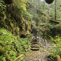
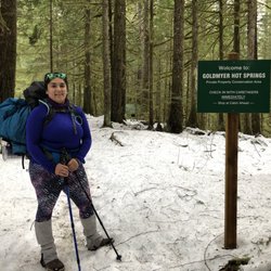
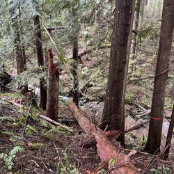
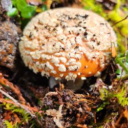
Annette Lake Photos


You might also consider
More like Annette Lake
Recommended Reviews - Annette Lake
Start your review...

Reviews With Photos - Annette Lake


One of my favorite hikes near Seattle. How have I not left a review? It's been closed for a while, but it now seems to be open? No more sign blocking the road to the trailhead. Recent snows have left the trail with lots of powder, but the lake has not frozen yet. The waterfall is flowing well and I got to see needle ice!

Came here on a weekday morning, arrived around 8AM. Potholes on the road to it (but it's short so not too bad), and plenty of parking. Trail was surrounded by trees, a few waterfalls, some spots were a bit muddy and there's a bit of snow at the very end. Very pretty lake, would recommend! Didn't see very many people on the way up, pretty much had the lake to ourselves, saw quite a few people on the way down though.

My Experience Level: I consider myself a beginner. I don't exercise much other than a neighborhood walk now and then. Length: 7.5 miles round trip, out & back per wta.org Elevation Gain: 1,800 feet per wta.org Time: 3.5 hours to reach the lake. 2.5 hours return trip. We took A LOT of breaks because going up to the lake was tiring. We went pretty slow on the way down because it was painful for a couple of us. We spent about an hour at the lake to have lunch/snacks. Parking: Northwest Forest Pass needed per wta.org. I bought an annual pass the day before from REI, so I didn't look at the on site pay station situation. I recommend purchasing your pass ahead of time to be safe. It's like a teardrop shaped lot and when we arrived on 9.5.20 around 8:30 AM, the edges were already full and a couple cars started to make an aisle in the middle. There's no lines to mark parking spaces. When we returned at 3:30 PM we could tell the lot had gotten full at some point, because some cars parked on the road outside the lot as "overflow". We did see some open spaces in the lot though at that time. Bathrooms: There is one in the parking lot. One toilet. No toilet paper that day, and no sink. Ladies will probably want to do the hover over the toilet. There was a lovely piece of hanging tape to catch the bugs. I held my breath to avoid smelling anything. There was a sign for toilets closer to the lake, but I was too scared to check it out. Gift Shop: None The Trail: I didn't see any trash debris along the way, which is nice. I don't think this hike is as popular as other lake trails, so I think the general crowd that does this is more respectful to nature and aware of hike etiquette. Most people wore masks (at least when passing each other). I think I only recall one group that didn't have any. The path is clear enough to tell where to go, but some parts are rocky and were hard on my ankles. I liked that you get the elevation gain out of the way going to the lake, so afterwards it's mainly downhill. But that ended up being hard on my knees. I had a walking staff, but have since purchased trekking poles because of this hike. Being in the trees majority of the time meant it was shaded and didn't get too hot. You pass electric poles at one point and can hear that buzzing, but luckily it's short part of it. Payoff: The lake was pretty and it was refreshing to wade in after the hike up, so waterproof shoes are recommended! But I don't think the lake was worth the soreness I endured, so I have no desire to do this one again, or recommend it to others unless you are more in shape and/or truly enjoy the journey. There's little spots around the lake your group can rest in while distancing from others. We got lucky with a sweet log to sit on and enjoy the view.


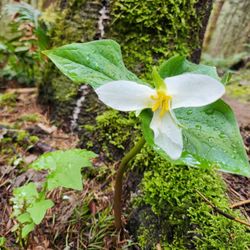
DON'T FORGET TO BRING INSECT REPELLANT!!! This is a great and moderate hike... about 7.5 miles round trip but when you get towards the end... the flies will swarm you. It gets really nasty. But that didn't stop us from eating our lunch by the lovely lake and for the two boys to jump into the freezing cold water. Daren D. is right about the rocks, there are lots of rocks but you get really cool views. You also pass by a few streams and a really awesome waterfall in the beginning. This trail is definitely less popular as the nearby hikes which made it really nice. Most of the other parties that were hiking brought their dogs and that's always fun to stop and aww at the cute canines. You'll see some flowers along the way too but lots of cool looking trees. The lake is the most gorgeous on a sunny day where you can see the trees' reflection off the water. Simply amazing. But seriously, don't forget to spray insect repellant or the flies will keep landing on you.

Awesome hike. I don't think it's for beginners as the trail is littered with rocks, roots, watch-your-steps, and some good drop-offs near certain edges... although, if you're in fairly good shape, eat/drink a bit prior, and pack some solid food and liquid, then I think you're golden if you take it in strides. There are 2-3 open clearings between dense forest where you're literally crossing a ~40 degree rock face. Pretty cool & scary for some. Great views and the lake is sweet. Our group chilled up here for a bit, while some of us got our feet wet and felt the soft, moist, shallow shore along the accessible half of shoreline. You do have to maneuver up and over a tricky section to pass the initial spot the trail dumps you at the lake to reach more area. Nice! See pics. Note: The outhouse at the trailhead sucks. :)

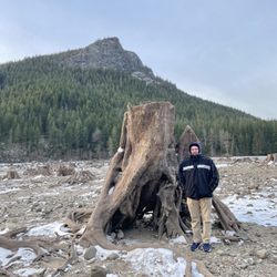
How beautiful. I hadn't researched or looked at photos of the lake so I wasn't expecting something so beautiful at the end of our moderately grueling hike. Here you can find a link to more info: http://www.wta.org/go-hiking/hikes/annette-lake We got to the lake and took a seat on a log while munching on some rewarding sour cream and onion chips. Best moment ever. There were plenty of other people so we grabbed some better than selfie images of ourselves which was nice. The lake felt serene and I wish we could have stayed longer, however the weather was trying and we wanted to make sure we didn't get caught in the rain. We left and I felt quite rewarded by our trek because the scenery was beautiful. I had recently been on a trip to New Zealand and thought this view was quite comparable to the North Island. I would certainly do this ~8 mile hike again any day and would take all of my hiking enthusiasts there as well. I wore waterproof boots which made jumping around the lake more enjoyable, I'd recommend doing the same. By the way, make sure you enter the correct trail. When we originally got to the trail head we took the nature trail which is roughly a mile loop and separate from Lake Annette. I don't regret this trail though because there was a seriously humorous phallic tree worth stopping at. As well as various bridges and numbered rocks to note. I'll post a photo of the tree for fun. Also, make sure you display the correct parking pass. The adventure pass is not the correct pass and will result in a $5 ticket.

For a beginner hiker, Annette Lake was more of a workout than I expected! You can anticipate most of the hike to be an incline with lots of switchbacks - be prepared for some rocky terrain as well. With the hike being just under 8 miles roundtrip, I feel like this hike may be a bit difficult for younger children. We did run into a few groups with dogs however, so the trail appears to be pretty pet-friendly. You can find another portable bathroom unit closer to the lake and it looked like a few folks were camping in the area as well (I'm not 100% sure if camping is encouraged..) Bring a light jacket if you're hiking on overcast days! The lakeside actually gets pretty cold when the sun isn't shining.


Hiked this trail today...I will say if your not a hiker this is not a trail for you!! Do not attempt if you have plans later in the afternoon. We arrived at 11:30am and didn't make it to the lake until 2:30. Then headed backwards at 3:30 and got to the car at 6! It's longgg and it feel like forever. This is definitely for people that have experience hiking.

One of my all-time favorite Washington hikes. This hike has it all - endless brooks, well-maintained trail, wildflowers, largely shaded by massive trees (can hike throughout the season even when hot), numerous vistas, several charming bridges, topped by a gorgeous alpine lake at trail-end. Highly doable hike at 7.5 miles, 1400 ft elevation gain. Parking lot gets crowded on weekends, so arrive early. Friendly for trailrunners and hikers alike.

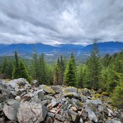
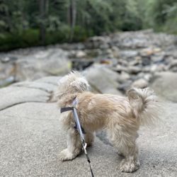
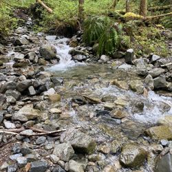
Annette Lake is an easy hike from the Snoqualmie Region. Difficulty: Easy Gains: 1400 ft Length: 7.5-8 miles round trip PROS: Trail: As a beginning hiker, it was pretty easy. The trail begins through the forest with a steady elevation. Ascending to the top, the elevation is gained during the first 1.5- 2 miles with lots of switchbacks. After 2 miles or so, the trail stays fairly flat. Very dog friendly. View: Towards the top, there are views of the different mountains from the north and west. You see natures beauty from the trees covering most of the trail along with rock formations, small water crossings, wild flowers and a couple of creeks. I came in mid April and there were still snow on the top! Annette Lake is beautiful and serene. My picture does not do justice because the camera on the phone is horrible! The water is calm, clean, clear and pretty shallow. The mountain surroundings and dense forest make a picturesque view. Maintenance: Overall the trail is pretty well maintained. There are some muddy areas from the water crossings. CONS: Parking: The parking lot is small so I can imagine it getting packed in the summer time. Bugs: Lots of mosquitoes! Bring bug spray! Pathway: Towards the top of the hike, there are some areas from the rock landslide that has lots of gravel on the trail. Becareful of the slippery rocks. *Northwest Forest Pass required*

1 month ago
Again, down the dirt road. On a Saturday it was crowded! Like holy cow! Arrived just before 9:00 am and was able to secure a spot in the lot. Thankfully I have a small car and can fit it into tight spaces. Discovery pass will not work here! Scan the QR code and pay $5.00 for a day pass. Or a northwest forest pass will work. The beginning is steep. With lots of stairs. You will begin to hate the stairs. Then just before you want to give up you've made it! A lovely well maintained trail. Parts of the trail go through clearings with views that give a view to just how high you are. And views of past gigantic rock slides. The weather at the lake today was cold. No snow on the trail but a bit on the mountains above. But it was cold! My hands started to hurt because it was so cold. After a brief picnic sitting on some logs with trout swimming below our feet we head back down. A back and forth hike just over 7.4 miles. Lovely!! Enjoy life. SYOY. read more


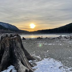
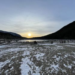
Annette lake is beautiful and so serene. I arrived May 17, Saturday at 9:30am and there was still plenty of spots in the lot. 8.8 miles, 2,150 ft of elevation gain and 4hrs out & back. There's a bathroom available but it smells very bad so I recommend going before the trailhead. 0.2 miles in theres the first viewpoint, a beautiful waterfall. There is still some snow at the top but you can make it without spikes or trekking poles. The lake is still partly frozen and the snow makes it even more serene. 10/10 would recommend this hike!! read more


4/16/25 I did not run into any other people on this hike until the last two miles which is a bit scary as bears frequent this country. Definitely bring micro spikes or snowshoes, starting two miles in you will need them. The lake is gorgeous and is beginning to thaw- there is a waterfall on the other side pouring into it. 7.37 miles, 2,014 ft elevation gain, 3 hrs to complete. read more


One of my favorite hikes near Seattle. How have I not left a review? It's been closed for a while, but it now seems to be open? No more sign blocking the road to the trailhead. Recent snows have left the trail with lots of powder, but the lake has not frozen yet. The waterfall is flowing well and I got to see needle ice! read more


Came here on a weekday morning, arrived around 8AM. Potholes on the road to it (but it's short so not too bad), and plenty of parking. Trail was surrounded by trees, a few waterfalls, some spots were a bit muddy and there's a bit of snow at the very end. Very pretty lake, would recommend! Didn't see very many people on the way up, pretty much had the lake to ourselves, saw quite a few people on the way down though. read more

My Experience Level: I consider myself a beginner. I don't exercise much other than a neighborhood walk now and then. Length: 7.5 miles round trip, out & back per wta.org Elevation Gain: 1,800 feet per wta.org Time: 3.5 hours to reach the lake. 2.5 hours return trip. We took A LOT of breaks because going up to the lake was tiring. We went pretty slow on the way down because it was painful for a couple of us. We spent about an hour at the lake to have lunch/snacks. Parking: Northwest Forest Pass needed per wta.org. I bought an annual pass the day before from REI, so I didn't look at the on site pay station situation. I recommend purchasing your pass ahead of time to be safe. It's like a teardrop shaped lot and when we arrived on 9.5.20 around 8:30 AM, the edges were already full and a couple cars started to make an aisle in the middle. There's no lines to mark parking spaces. When we returned at 3:30 PM we could tell the lot had gotten full at some point, because some cars parked on the road outside the lot as "overflow". We did see some open spaces in the lot though at that time. Bathrooms: There is one in the parking lot. One toilet. No toilet paper that day, and no sink. Ladies will probably want to do the hover over the toilet. There was a lovely piece of hanging tape to catch the bugs. I held my breath to avoid smelling anything. There was a sign for toilets closer to the lake, but I was too scared to check it out. Gift Shop: None The Trail: I didn't see any trash debris along the way, which is nice. I don't think this hike is as popular as other lake trails, so I think the general crowd that does this is more respectful to nature and aware of hike etiquette. Most people wore masks (at least when passing each other). I think I only recall one group that didn't have any. The path is clear enough to tell where to go, but some parts are rocky and were hard on my ankles. I liked that you get the elevation gain out of the way going to the lake, so afterwards it's mainly downhill. But that ended up being hard on my knees. I had a walking staff, but have since purchased trekking poles because of this hike. Being in the trees majority of the time meant it was shaded and didn't get too hot. You pass electric poles at one point and can hear that buzzing, but luckily it's short part of it. Payoff: The lake was pretty and it was refreshing to wade in after the hike up, so waterproof shoes are recommended! But I don't think the lake was worth the soreness I endured, so I have no desire to do this one again, or recommend it to others unless you are more in shape and/or truly enjoy the journey. There's little spots around the lake your group can rest in while distancing from others. We got lucky with a sweet log to sit on and enjoy the view. read more


 - Hiking Near Me")


3 years ago
So beautiful!! I came here only because Denny creek was closed. The hike wasn't hard for me a relatively fit person but I would definitely not say it was easy. It was a great workout with a even better reward than any gym can give you. Definitely recommend! Dog friendly. read more


DON'T FORGET TO BRING INSECT REPELLANT!!! This is a great and moderate hike... about 7.5 miles round trip but when you get towards the end... the flies will swarm you. It gets really nasty. But that didn't stop us from eating our lunch by the lovely lake and for the two boys to jump into the freezing cold water. Daren D. is right about the rocks, there are lots of rocks but you get really cool views. You also pass by a few streams and a really awesome waterfall in the beginning. This trail is definitely less popular as the nearby hikes which made it really nice. Most of the other parties that were hiking brought their dogs and that's always fun to stop and aww at the cute canines. You'll see some flowers along the way too but lots of cool looking trees. The lake is the most gorgeous on a sunny day where you can see the trees' reflection off the water. Simply amazing. But seriously, don't forget to spray insect repellant or the flies will keep landing on you. read more


Awesome hike. I don't think it's for beginners as the trail is littered with rocks, roots, watch-your-steps, and some good drop-offs near certain edges... although, if you're in fairly good shape, eat/drink a bit prior, and pack some solid food and liquid, then I think you're golden if you take it in strides. There are 2-3 open clearings between dense forest where you're literally crossing a ~40 degree rock face. Pretty cool & scary for some. Great views and the lake is sweet. Our group chilled up here for a bit, while some of us got our feet wet and felt the soft, moist, shallow shore along the accessible half of shoreline. You do have to maneuver up and over a tricky section to pass the initial spot the trail dumps you at the lake to reach more area. Nice! See pics. Note: The outhouse at the trailhead sucks. :) read more

. - Hiking Near Me")


How beautiful. I hadn't researched or looked at photos of the lake so I wasn't expecting something so beautiful at the end of our moderately grueling hike. Here you can find a link to more info: http://www.wta.org/go-hiking/hikes/annette-lake We got to the lake and took a seat on a log while munching on some rewarding sour cream and onion chips. Best moment ever. There were plenty of other people so we grabbed some better than selfie images of ourselves which was nice. The lake felt serene and I wish we could have stayed longer, however the weather was trying and we wanted to make sure we didn't get caught in the rain. We left and I felt quite rewarded by our trek because the scenery was beautiful. I had recently been on a trip to New Zealand and thought this view was quite comparable to the North Island. I would certainly do this ~8 mile hike again any day and would take all of my hiking enthusiasts there as well. I wore waterproof boots which made jumping around the lake more enjoyable, I'd recommend doing the same. By the way, make sure you enter the correct trail. When we originally got to the trail head we took the nature trail which is roughly a mile loop and separate from Lake Annette. I don't regret this trail though because there was a seriously humorous phallic tree worth stopping at. As well as various bridges and numbered rocks to note. I'll post a photo of the tree for fun. Also, make sure you display the correct parking pass. The adventure pass is not the correct pass and will result in a $5 ticket. read more


12 years ago
For a beginner hiker, Annette Lake was more of a workout than I expected! You can anticipate most of the hike to be an incline with lots of switchbacks - be prepared for some rocky terrain as well. With the hike being just under 8 miles roundtrip, I feel like this hike may be a bit difficult for younger children. We did run into a few groups with dogs however, so the trail appears to be pretty pet-friendly. You can find another portable bathroom unit closer to the lake and it looked like a few folks were camping in the area as well (I'm not 100% sure if camping is encouraged..) Bring a light jacket if you're hiking on overcast days! The lakeside actually gets pretty cold when the sun isn't shining. read more


I didn't expect it to be too beautiful because subjectively, I like the lake scene when the snow is still there. However, considering the trail is not too difficult, I do think it's worth the hike. It was around 70 yesterday but the water wasn't too cold read more


Hiked this trail today...I will say if your not a hiker this is not a trail for you!! Do not attempt if you have plans later in the afternoon. We arrived at 11:30am and didn't make it to the lake until 2:30. Then headed backwards at 3:30 and got to the car at 6! It's longgg and it feel like forever. This is definitely for people that have experience hiking. read more

10 years ago
One of my all-time favorite Washington hikes. This hike has it all - endless brooks, well-maintained trail, wildflowers, largely shaded by massive trees (can hike throughout the season even when hot), numerous vistas, several charming bridges, topped by a gorgeous alpine lake at trail-end. Highly doable hike at 7.5 miles, 1400 ft elevation gain. Parking lot gets crowded on weekends, so arrive early. Friendly for trailrunners and hikers alike. read more


11 years ago
Annette Lake is an easy hike from the Snoqualmie Region. Difficulty: Easy Gains: 1400 ft Length: 7.5-8 miles round trip PROS: Trail: As a beginning hiker, it was pretty easy. The trail begins through the forest with a steady elevation. Ascending to the top, the elevation is gained during the first 1.5- 2 miles with lots of switchbacks. After 2 miles or so, the trail stays fairly flat. Very dog friendly. View: Towards the top, there are views of the different mountains from the north and west. You see natures beauty from the trees covering most of the trail along with rock formations, small water crossings, wild flowers and a couple of creeks. I came in mid April and there were still snow on the top! Annette Lake is beautiful and serene. My picture does not do justice because the camera on the phone is horrible! The water is calm, clean, clear and pretty shallow. The mountain surroundings and dense forest make a picturesque view. Maintenance: Overall the trail is pretty well maintained. There are some muddy areas from the water crossings. CONS: Parking: The parking lot is small so I can imagine it getting packed in the summer time. Bugs: Lots of mosquitoes! Bring bug spray! Pathway: Towards the top of the hike, there are some areas from the rock landslide that has lots of gravel on the trail. Becareful of the slippery rocks. *Northwest Forest Pass required* read more


7 years ago
Definitely a snow hike in March/April. My group all had hiking boots (with spikes) and poles which helped. The first half of the trail the snow has mostly melted. The second half still has a lot of snow, so we had to be careful to not slip or else risk sliding all the way back to the trailhead. Despite the 4 miles to get to the lake, the elevation gain was not challenging at all. And view of the lake was great. read more

11 years ago
One of most beautiful hikes I've been on. The trail had been well-maintained and the views are breath taking. I had a very pleasant experience hiking up to the lake with my friend and dog. Distance: 7.5 miles round trip Bugs: bring bug spray! There's a lot of Mosquitos at the lake Parking: decent amount of parking.. Can't probably fit about 20-30 cars? If you don't have the pass, you will be charged a $5 fee Difficulty: beginner. The trail is very straightforward, there's decent pacing between flats and inclines, and not too many switchbacks (maybe 5?). It's also very dog friendly! It took us about 2 hours to climb up, which included a couple of picture and water breaks. Definitely bring a camera because the trail is extremely gorgeous! read more


15 years ago
The stats:48 miles from Seattle; Exit 47 on I-90, turn right and follow the signs; 7 miles out and back with a 1900 elevation gain. Piece of cake. If the parking lot is full, street parking is available. Passes are required. This may not be for beginners or out-of-shape people.But it is a fanstastic hike if you don't know if you are in good enough condition. After about a mile on the trail, you have the option of simply hanging a left and going on a flat trail to the Snoqualmie Tunnel. Be sure to bring a flashlight if that's an option. As with all hikes on the I-90 corridor, it's crowded with Subaru-driving, dog-walking Seattlelites wearing wide-brimmed hats trotting down the trail with their two walking sticks flailing away (not that there's anything wrong with that). If you can avoid weekends... do. There are a few payoffs along the way in the form of rock-slides, waterfalls, and views of the adjoining mountain. There is a beautiful mountain lake at the end of the trail with lots of trout. It looks like there are a few places to camp and or picnic up there. Saw lots of kids, dogs, elderly people. For me, I like to run down the trail. Not up... just down. The Annette Lake trail is awesome for that. Just enough technical stuff to keep you interested. read more


Much flies at the lake. There isn't much areas to chill and get a good view of the lake because it's basically forested area. But the hike itself was easy and very entertaining along the way. You get glimpses of streams, open views of the mountain range across. Careful at rocky areas where it's like large pebbles as you can easily slip. If you want you can easily run down this too, relatively downhill flat.. But going up may be hard for some beginners Also, the length says it's only 8 miles at trail head, felt way longer than that. Perfect place for camping and fishing too! read more


13 years ago
Difficult ascent over the first 2 miles up, be prepared with bug spray as it can get rough. Once you are beyond the first 2 miles trail climb, it becomes flat leading to the Lake. The views are excellent on the way up, be careful as the trail winds and there are several ledges that require caution. We make the hike with our kiddos, however, you need to keep them close and hold on tight as the drop offs are a little rough at times. The Lake is a great reward for the climb and the water is crystal clear and beautiful, albeit cold- even in late summer. The trail is full of blackberries in summer which is a bonus. Take plenty of water and a protein bar, you will need them! Enjoy, this gem of a trail, Happy hiking! read more

Man there was still snow! In May =( I suppose I sorta knew because a lot of ppl wrote about it but I just didn't believe it. Sure enough, halfway up, we were stopped by the snow. We weren't dressed for it. This wasn't very difficult for me but it was definitely a workout! I didn't get to see the lake and I'm bummed about that. We only saw 2 ppl on the way up so I did appreciate that because after all, when I go hiking, I'm not looking to socialize with other ppl. I really just want to be out nature with my boyfriend and our doggies =) I'll update it when I come back in the summer. read more

This hike is perfect. You get the best of everything (waterfall, lake, cliff, rocks, green). It's an 8 mile hike that isn't too difficult and isn't too easy. One of my favorite hikes within 1 hour of the city which includes snow lake and rattlesnake ridge read more


13 years ago
The most beautiful hike I've ever been on. Good for intermediate hikers. Has a clean Porter Potty at the start, use it because the hike is long. The trails is about 4 miles each way, and the elevation gain is mostly steady, although a few stretches can get steeper. It has a nice warm-up starting and the last mile or so is mostly downhill or is very gentle, so it's a nice cool down and a relief for the tired hikers. This has been the only trail that has been so beautiful from the word go. The entire trail is pretty, with little wildflowers and small to big snow-melt streams lining the way. The Lake is breathtaking. We had a long lunch on one of the logs at the edges, we didn't want to leave! There are curious fish in the lake that nip at the surface every once in a while, and I saw many campers/fishers there. Wear good shoes, because some of the stretches are damp and has snow melt water. You also have to walk over rocks and stones. The parking lot uses the Northwest pass, not the yellow national parks pass we normally use. I want to go back here again and again. read more

I hiked this on a rainy Monday afternoon with a dog. It was cold and very quiet. The trail was occasionally steep and slippery, but nothing terribly difficult. The dog and I made it and couldn't be happier. I recommended going NOW to catch the stunning fall foliage that can be viewed from the upper parts of the hike. Check out my pictures and you'll see what I mean. read more


11 years ago
This is a beautiful yet challenging trail for the average hiker. We went in early spring so there was still snow on the top half of the trail. It would have been much easier if we had the right shoes and poles to deal with the snow. Our son is 9 and made it up and back - with a little complaining :-) You will need to keep a close eye on your kids in a few spots. Next time we will wait for warmer weather and camp a night or two at the top. We also took our dog. It's wonderful when we get to take him along. He is pretty small though and slept well when we got home. Be sure to take protein bars and plenty of water. If you start early morning you can have lunch at the top. read more


11 years ago
So beautiful. Wear hiking boots. Not much of an elevation gain but about 8 miles. Serene and beautiful. Take food and water. Bring discovery pass for parking or keep 5$ cash Incase u don't have one. One toilet at the parking lot and one when you approach the lake. We did this hike on a cloudy and rainy day but it was still so beautiful. read more


11 years ago
Decent incline the first couple miles, then flattens out. The entire trail is beautiful, mostly shade. The lake at the top is STUNNING. Pictures don't do it justice. Wonderful to take a swim at the top. read more


10 years ago
11 years ago
11 years ago
9 years ago
More info about Annette Lake
Ask the Community - Annette Lake
Review Highlights - Annette Lake
You might also consider


Why does Yelp recommend reviews?
3 reviews that are not currently recommended
The reviews below are not factored into the business's overall star rating.
13 years ago
3 years ago
12 years ago
Annette Lake - hiking - Updated July 2026
Best of North Bend
People found Annette Lake by searching for…
Hiking Trails With Waterfalls in North Bend, WA
Swimming Lakes in North Bend, WA
Swimming Holes in North Bend, WA
Fishing Spots in North Bend, WA
Things to Do in North Bend, WA
Picnic Areas in North Bend, WA
Parks for Kids in North Bend, WA
Places to Take Pictures in North Bend, WA
Trout Fishing in North Bend, WA
Dog Swimming in North Bend, WA
Beautiful Views in North Bend, WA
Fishing Lake in North Bend, WA
Sledding Hills in North Bend, WA
Picnic Spots in North Bend, WA
Off Road Trails in North Bend, WA
Trending Searches in North Bend, WA
Beautiful Views in North Bend, WA
Black Owned Nail Salons in North Bend, WA
Blueberry Picking in North Bend, WA
Cliff Jumping in North Bend, WA
Dog Friendly Trails in North Bend, WA
Dog Swimming in North Bend, WA
Free Picnic Areas in North Bend, WA
Jet Ski Rental in North Bend, WA
Kayak Rental in North Bend, WA
Lakes & Ponds in North Bend, WA
Off Road Trails in North Bend, WA
Outdoor Activities in North Bend, WA
Outdoor Basketball Courts in North Bend, WA
Picnic Spots in North Bend, WA
Places To Walk Around in North Bend, WA
Public Pools in North Bend, WA
Public Shower in North Bend, WA
River Swimming in North Bend, WA
River Tubing in North Bend, WA
Running Trails in North Bend, WA
Scenic Night View in North Bend, WA
Scenic Overlook in North Bend, WA
Scenic Restaurants in North Bend, WA
Soccer Store in North Bend, WA
Sunrise View in North Bend, WA
Swimming Holes in North Bend, WA
Swimming Lakes in North Bend, WA
Watch Sunset in North Bend, WA
Browse Nearby
Browse Brands
Related Searches in North Bend, WA
Affordable Kayak Rental Services in North Bend, Washington
Best Fishing Locations and Guides in North Bend, Washington
Best Nature Trails for Hiking in North Bend, Washington
Best Places for Horseback Riding in North Bend, Washington
Best Waterfalls and Swimming Holes in North Bend, Washington
Check Out Off Road Trails in North Bend, Washington
Discover Dog Friendly Trails to Explore in North Bend, Washington
Discover Lakes & Ponds to Explore in North Bend, Washington
Discover Scenic Mountain Bike Trails Near North Bend, Washington
Discover Scenic Waterfall Spots in North Bend, Washington
Discover Top Boat Tours in North Bend, Washington for All Ages
Discover Top Nature Parks to Visit in North Bend, Washington
Discover Top State Parks to Visit in North Bend, Washington
Discover Walking Parks in North Bend, Washington Near You
Discover a Hiking Trail in North Bend, Washington
Discover the Best Beaches in North Bend, Washington
Discover the Best Fishing Lake in North Bend, Washington
Discover the Best Night Hike Trails in North Bend, Washington
Discover the Best Tide Pools in North Bend, Washington
Dog-Friendly Hikes With Dogs in North Bend, Washington
Enjoy Camping Adventures Around North Bend, Washington
Enjoy Exciting Mountain Biking Adventures in North Bend, Washington
Enjoy Kayaking Adventures in North Bend, Washington
Enjoy Tent Camping Spots Around North Bend, Washington
Enjoy Water Activities and Fun in North Bend, Washington
Enjoy a Beautiful Waterfall Hike in North Bend, Washington
Enjoy the Best Picnic Spots and Ideas in North Bend, Washington
Enjoy the Best Walking Path in North Bend, Washington
Enjoy the Best Walking Trails in North Bend, Washington
Experience Thrilling White Water Rafting in North Bend, Washington
Explore Beautiful Parks and Green Spaces in North Bend, Washington
Explore Boat Rentals for Every Need in North Bend, Washington
Explore Easy Hikes Perfect for All in North Bend, Washington
Explore Fun Activities to Do in North Bend, Washington
Explore Parks With Lakes to Visit in North Bend, Washington
Explore Popular Campgrounds Near North Bend, Washington
Explore Popular Picnic Areas Around North Bend, Washington
Explore Popular RV Parks Around North Bend, Washington
Explore Popular Scenic Views Near North Bend, Washington
Explore Top Dog Parks in North Bend, Washington Near You
Explore Top Marinas Near North Bend, Washington
Explore Top Water Parks in North Bend, Washington Today
Explore the Best Beach Spots in North Bend, Washington
Explore the Best Boating Spots in North Bend, Washington
Explore the Best Swimming Holes Around North Bend, Washington
Explore the Best Trail Options in North Bend, Washington
Explore the Scenic River in North Bend, Washington
Family Friendly Hiking With Kids in North Bend, Washington
Find Beautiful Views in North Bend, Washington
Find Parks and Recreation Activities in North Bend, Washington
Browse Articles
People who viewed Annette Lake also viewed
Rattlesnake Ledge Trail
214 reviews
Bandera Mountain
13 reviews
Franklin Falls Trailhead
142 reviews
Big Creek Falls - Taylor River Trail
3 reviews
Kanaskat-Palmer State Park
23 reviews
Little Si
107 reviews
lodge lake Trail
3 reviews
Federation Forest State Park
1 review
Snoqualmie Point Park
18 reviews
Dirty Harry's Balcony
10 reviews