Weeks Falls Interpretive Trail Photos


More like Weeks Falls Interpretive Trail
Recommended Reviews - Weeks Falls Interpretive Trail
Start your review...

Reviews With Photos

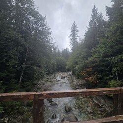
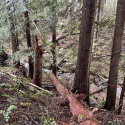
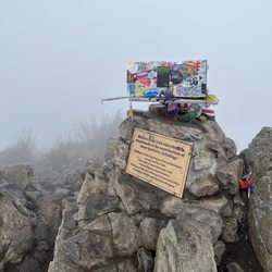
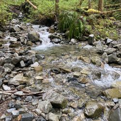
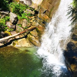
Not much has changed since the first review was posted. We parked at the end where the dam and falls are located. There are only a couple spots at that end, whereas if you park at the front entrance of the park there is a lot more room. Either way the trail is a short, dirt out & back path through a beautiful old growth forest along the Snoqualmie River. The falls are fairly short, but pretty as they travel through boulders. You can check out the history of the small hydro building at the base of the falls, and read a few interpretive signs regarding usage of the trail in days long past. There are multiple stair options down to the rivers edge along the way, and the trail separates briefly into 2 paths, wider at times and shrinking to quite narrow at some points. We had the place to ourselves that morning. It's a very peaceful and shaded trail, easy for anyone to take. As short as it is you might not go out of the way for this trail, but it's easy to find and right off of the freeway, so why not!

4 months ago
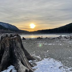
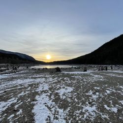
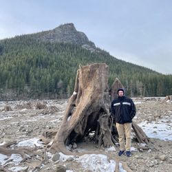
A short walk to the falls, but it was beautiful, and lots of spots along the water that you can walk to get closer to it. We enjoyed a nice snowy hike and it was really nice and quiet, not many people there which is always a bonus. There's a bathroom at the trailhead and another on the way to the falls. read more


3 years ago
Dry path and barely anyone there. Nice easy stroll to the water. Didn't see any poop bags but didn't grab a silica packet dropped by someone and pitched it when we finished the hike. It's not a glamorous hike to the cement when it's in view but the overlooks are really pretty... I'd give it 4.5 stars but that's not possible hence the 4. It was super pleasant being down by the water and there were dozens of butterflies pollinating in bushes- they captivated us for a while at the water. We will be back- it's always nice to have a short and sweet hike option to be in nature. Hiked 6.22.2023 read more


2 years ago
Short hike perfect for little kids. Also very clean and safe. Requires a discovery pass. Or you can get a day pass right at the entrance. read more


Not much has changed since the first review was posted. We parked at the end where the dam and falls are located. There are only a couple spots at that end, whereas if you park at the front entrance of the park there is a lot more room. Either way the trail is a short, dirt out & back path through a beautiful old growth forest along the Snoqualmie River. The falls are fairly short, but pretty as they travel through boulders. You can check out the history of the small hydro building at the base of the falls, and read a few interpretive signs regarding usage of the trail in days long past. There are multiple stair options down to the rivers edge along the way, and the trail separates briefly into 2 paths, wider at times and shrinking to quite narrow at some points. We had the place to ourselves that morning. It's a very peaceful and shaded trail, easy for anyone to take. As short as it is you might not go out of the way for this trail, but it's easy to find and right off of the freeway, so why not! read more


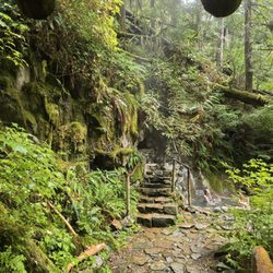
I learned about Weeks Falls from an Instagram account I follow, and she noted that it was a great spot for younger kids. My 2 (almost 3) year old loooves to "hike" and find bugs, so on National Get Outdoors Day, I decided to pack up the car and head to the trail! Finding it was a little bit of a challenge. WTA and AllTrails don't do the best job of explaining, so we ended up at another trailhead before we got it right. I posted a photo here on Yelp with a description that really helped me find the right spot. The parking lot is nice and open, and very close to a residential space and the Ranger Station, so it's really safe! The trail runs along the river, and there's several paths down to the water so you can enjoy the view, eat lunch, or in our case, throw rocks into the river. It's pretty shaded the entire time, which will be nice during really warm days. When you're nearly to the falls the trail opens up to a paved pathway, and on the right there's a bathroom (great for little bladders!!). Once you keep going past that, you start to hear the falls and the hydroelectric plant. You can go down the stairs and read about the plant, and there's great views of the water from this space. Once you keep walking, maybe thirty seconds longer, you'll find the falls. It's a pretty view and has a big stone wall with a big rail to protect little ones. That being said, there's a few spots where kids could definitely slip through and drop down to the water - so just be cautious and alert! The trail is flat the entire way (36 feet of elevation gain) so it's really easy and fun for kids. Throughout the hike there's educational wooden boards to share knowledge about the forest and the hydroelectric plant. All in all, my toddler loved it and it's a beautiful spot to play and eat lunch (there's several clean picnic tables!) read more


More info about Weeks Falls Interpretive Trail
51350 SE Homestead Valley Rd
North Bend, WA 98045
Directions
Hours
Outdoor Amenities


Weeks Falls Interpretive Trail - hiking - Updated June 2026
Best of North Bend
People found Weeks Falls Interpretive Trail by searching for…
Scenic View in North Bend, Washington
Photo Spots in North Bend, Washington
Paved Walking Trails in North Bend, Washington
Picnic Areas in North Bend, Washington
Easy Hiking Trails in North Bend, Washington
Parks in North Bend, Washington
Hiking Trails With Waterfalls in North Bend, Washington
Picnic Spots in North Bend, Washington
Things to Do in North Bend, Washington
Fun Things to Do With Kids in North Bend, Washington
Trails in North Bend, Washington
Scenic Overlook in North Bend, Washington
Lookout Points in North Bend, Washington
Restaurants With a View in North Bend, Washington
Running Trails in North Bend, Washington
Running Stairs in North Bend, Washington
View Points in North Bend, Washington
Waterfalls and Swimming Holes in North Bend, Washington
Scenic Spots in North Bend, Washington
Places to Take Pictures in North Bend, Washington
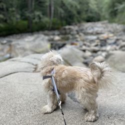
Off Leash Dog Hikes in North Bend, Washington
Trending Searches in North Bend, WA
Black Owned Nail Salons near Weeks Falls Interpretive Trail
Boat Rental near Weeks Falls Interpretive Trail
Cliff Jumping near Weeks Falls Interpretive Trail
Creeks near Weeks Falls Interpretive Trail
Day Trips near Weeks Falls Interpretive Trail
Dog Friendly Trails near Weeks Falls Interpretive Trail
Fireworks near Weeks Falls Interpretive Trail
Fishing Spots near Weeks Falls Interpretive Trail
Jet Ski Rental near Weeks Falls Interpretive Trail
Kayak Rental near Weeks Falls Interpretive Trail
Lakes & Ponds near Weeks Falls Interpretive Trail
Outdoor Activities near Weeks Falls Interpretive Trail
Places To Walk Around near Weeks Falls Interpretive Trail
Public Pools near Weeks Falls Interpretive Trail
Public Shower near Weeks Falls Interpretive Trail
River Swimming near Weeks Falls Interpretive Trail
Rock Quarry near Weeks Falls Interpretive Trail
Scenic Night View near Weeks Falls Interpretive Trail
Scenic Overlook near Weeks Falls Interpretive Trail
Secluded Spots near Weeks Falls Interpretive Trail
Soccer Store near Weeks Falls Interpretive Trail
Splash Pad near Weeks Falls Interpretive Trail
Strawberry Picking near Weeks Falls Interpretive Trail
Sunrise View near Weeks Falls Interpretive Trail
Swimming Holes near Weeks Falls Interpretive Trail
Swimming Lakes near Weeks Falls Interpretive Trail
Watch Sunset near Weeks Falls Interpretive Trail
Browse Articles
Browse Nearby
BEST of North Bend, Washington Coffee near Weeks Falls Interpretive Trail
BEST of North Bend, Washington Restaurants near Weeks Falls Interpretive Trail
BEST of North Bend, Washington Breakfast near Weeks Falls Interpretive Trail
BEST of North Bend, Washington Wineries near Weeks Falls Interpretive Trail
Browse Brands
Related Searches in North Bend, WA
Affordable Kayak Rental Services in North Bend, Washington
Best Fishing Locations and Guides in North Bend, Washington
Best Nature Trails for Hiking in North Bend, Washington
Best Places for Horseback Riding in North Bend, Washington
Check Out Off Road Trails in North Bend, Washington
Discover Dog Friendly Trails to Explore in North Bend, Washington
Discover Scenic Mountain Bike Trails Near North Bend, Washington
Discover Scenic Waterfall Spots in North Bend, Washington
Discover Top Nature Parks to Visit in North Bend, Washington
Discover Walking Parks in North Bend, Washington Near You
Discover a Hiking Trail in North Bend, Washington
Discover the Best Night Hike Trails in North Bend, Washington
Dog-Friendly Hikes With Dogs in North Bend, Washington
Enjoy Camping Adventures Around North Bend, Washington
Enjoy Exciting Mountain Biking Adventures in North Bend, Washington
Enjoy Kayaking Adventures in North Bend, Washington
Enjoy Tent Camping Spots Around North Bend, Washington
Enjoy a Beautiful Waterfall Hike in North Bend, Washington
Enjoy the Best Picnic Spots and Ideas in North Bend, Washington
Enjoy the Best Walking Path in North Bend, Washington
Enjoy the Best Walking Trails in North Bend, Washington
Experience Thrilling White Water Rafting in North Bend, Washington
Explore Beautiful Parks and Green Spaces in North Bend, Washington
Explore Easy Hikes Perfect for All in North Bend, Washington
Explore Fun Activities to Do in North Bend, Washington
Explore Popular Campgrounds Near North Bend, Washington
Explore the Best Beach Spots in North Bend, Washington
Explore the Best Swimming Holes Around North Bend, Washington
Explore the Best Trail Options in North Bend, Washington
Family Friendly Hiking With Kids in North Bend, Washington
Find Beautiful Views in North Bend, Washington
Find Popular Ziplining Spots Around North Bend, Washington
Find the Best Parks for Picnics in North Bend, Washington
Find the Best Scenic View Locations in North Bend, Washington
Great Places to Walk in North Bend, Washington
Hike the Popular Waterfall Trail in North Bend, Washington
Hiking Trails With Waterfalls in North Bend, Washington
Off Leash Dog Hiking Trails in North Bend, Washington
Plan a Scenic Drive Route Near North Bend, Washington
Popular Outdoor Activities to Try in North Bend, Washington
Popular Picnic Spots to Visit in North Bend, Washington
Safe River Swimming Areas in North Bend, Washington
Safe and Fun Parks for Kids in North Bend, Washington
Top Climbing Spots and Gyms in North Bend, Washington
Top Paddleboarding Activities in North Bend, Washington
Top Running Trails to Explore in North Bend, Washington
Top Swimming Lakes to Enjoy in North Bend, Washington
Top Swimming Spots and Pools in North Bend, Washington
Walk Dog Friendly Hiking Trails in North Bend, Washington
Walk the Best Paved Walking Trails in North Bend, Washington