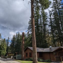
Poo Poo Point Photos


You might also consider
More like Poo Poo Point
Recommended Reviews - Poo Poo Point
Start your review...

Reviews With Photos


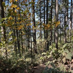
Great hike! We recently hiked Poo Poo Point on an early Saturday morning and really enjoyed it! We had heard from multiple people the parking lot filled up quickly so we arrived early, about 7:30 am and, surprisingly, we still only got one of a couple parking spots remaining at that hour. Make sure to have a lot of water and a light snack that you can enjoy once at the peak. The terrain is fairly steep and rocky but the trail has been built with the assistance of the rocks, with many spots having stairs built out of rocks. It took us about 2 hours, at a leisurely pace, to get to the very top where we enjoyed a light snack and spectacular views. The hike itself was a pretty steep incline; at times, its like you were on a StairMaster, just walking up flights of stairs with no end in sight. Once you're at the top, you have a beautiful view of Mount Rainier. I really enjoy this hike! I recommend coming early. It's a very busy trailhead with limited parking. They also have a paragliding spot at the top. There is a beautiful view of Mt Rainer close to the top. The view is incredible and loved watching the paragliders take off!

This is not a hike for beginners... It's a very steep mountain and is full of steps to go up. I went to the top and it was hard ( and I am used to hike ....) Going down the mountain is harder .... The trail is very narrow so u have to stop and let people pass which is ok so you can catch ur breath lol I highly recommend this hike but be prepared to a hard hike that will kick ur ass big time lol Its worthy to see the wonderful views of Mount Rainier and lake Samamish . Have a great hike !

The trailhead is off of the I-90 Front Street exit in Issaquah. You can't beat the convenience to Seattle if that's where you're coming from. I arrived at 830am on a Saturday and the parking lot was full. There is a property just before the parking lot that has about 80 parking spaces and they charges $5. Cash only. There is also no change available so just be ready, it's just somebody's personal property. The trail begins with a sign that says Chirico Trail, but it leads to Poo Poo Point. Immediately, your climb begins and it feels like it doesn't end. I believe it's around 3.8 miles round trip with 1900 feet elevation gain. It felt longer going up. I've recently done little si and rattlesnake and for some reason this one just had me winded within 20 mins of the hike. There are a lot of medium sized rocks on this trailhead and there's no real section of easy hiking to the top. Once you get to the top there's an opening where you can see Mt. Rainier. You'll then continue another 1/4 mile to Poo Poo Point with views of downtown Bellevue and lake sammamish. If you're lucky you'll get to watch paragliders or parachutes take off from the top. There's plenty of space and picnic tables at the top to have lunch and relax.

This is based on the Chirico trail, I LOVE THIS HIKE. Note: I havent gone intense hiking in a long time- newbie Suprisingly I got parking in the small lot at 11:20 fter waiting 10 minutes on a Saturday. There is a high school and park down the road with plenty of space, but there are people who choose to recieve a 20 dollar fine parking along the two way road. For years this has caused safety concerns, but I learned on Komo 5 News they cant extend parking because of protected land. When starting the hike I didnt know what I was facing so I overpacked for a 3.4 round trip hike. Starting the actual trail there are a whole bunch of rocks with a narrow path so please be careful and aware of other hikers. The incline was a killer on my calves. The other hikers were so supportive/nice. The top is worth the hour, I arrived at 12:30 and stayed for 40 minutes. I heard there is more of a hike to see people paragliding/hangliding and I am for sure going to see this on my next hike here. Then I left, on the way down is a breeze. I aboslutely love this place in Issaquah. There are a ton of dogs and runners, its crazy how they can workout through this incline.

gonna be honest--this was 10x harder than I thought it was going to be. i mean i wouldn't consider myself an advanced hiker but i have done quite a few hikes in my day. this was hard. steep and long. but at the same time, worth it. felt good to get to the top. overall, i recommend; just know what you're getting in for.

After driving in circles and asking two different people for directions, I found the trail head. The first guy steered me wrong and I ended up on the Rainier Trail across the street. The guy I met on that path steered me right and described the entire hike for me, which left me slightly terrified but grateful to not be driving in circles anymore. The entrance to Poo Poo Point is literally between parked cars in a neighborhood by the high school. Like entering Narnia only with less outerwear. The second guy told me, "just keep going right" once on the trail and he was spot on. I often marvel at how easy some people make hiking look. As an amateur hiker I'm still building up my endurance, and am the red-faced sweaty mouth-breather waiting for you to pass. This is the second solo hike I've done in recent weeks and this one definitely left me with noodle legs. I exclaimed to a group of hikers on their way down (when I was about halfway up), "You're still alive! That's good." To which one responded, "Yeah, but it only gets harder from here." I was like, "Are you kidding me?!" He wasn't kidding me. It took me just under two hours to reach the summit and I almost gave up. My reward for pushing through the pain was a front row seat to paragliders launching off the side of Tiger Mountain. What a sight! My muscles were sore for three days, but I appreciated the wooded covering during the hike and the sweet sounds of birds and breeze in the trees. Lots of moss and wildflowers and a panoramic view at the top. I will pace myself better this month, but hope to come back to Poo Poo Point when I'm feeling a bit more dangerous. Parking is limited, so find a spot at the high school and walk over to the entrance. If you see the well-marked Rainier Trail Park sign, cross the street to Narnia.


Being a 20 minute drive from Seattle, you really can't ask for more! Beautiful moss covered trees, challenging yet not too strenuous elevation gain, and then a few extremely rewarding look out spots from the top! You can see in just about every direction, which is pretty awesome! High point to recognize, being so close to civilization, this is a very popular hike on a nice weekend. So go on a week day if you want a slightly more serene hike.

PooPoo Point is fun to say! Lol (real mature, right? Haha) but anyway! 2 of my cousins and I hiked this for the first time, and I've been wanting to hike this again! It was pretty killer! I do cardio almost every day but when you add some sort of elevation... OoOowee!! I jogged up for a 1/2 mile going up some "rock stairs" I had a good momentum going for me. - Took me 4.5 hours round trip, we of course took some pictures, ate lunch. Once you reach a vast grassy area with a view you know, you have reached the top of the hill. However, there's another trail entrance I think another 1.5 miles up - DO IT! much more worth it. The top of the higher elevation is where they para-glide.

I read in several different places that this trail is considered moderate. If this is moderate I'd hate to see what difficult is! This trail is an agonizing 4.1 mile uphill hike, one way. Those who call it moderate are in a hell of a lot better shape than I'm in and I wouldn't necessarily say I'm out of shape but this was HARD! It took us about 3 hours to make it to the top and that was with many rest stops. The way down was definitely faster but not necessarily a lot easier. The view at the top was really nice. The weather was great so there were a lot of para gliders launching. It was so neat to watch. I had pictured myself getting to the top and finding a nice patch of grass to doze in for 30 minutes or so, but there aren't a lot of grassy patches there that are conducive to napping. It was beautiful for sure, but worth the agony? I'm not sure. I definitely don't see myself doing it again. I also find myself enjoying hikes that have more scenery throughout not just at the top. There was definitely not a lot to see on this hike but trees. We were pretty sore for about two days after. Best place to begin the trail is at the Issaquah high school were parking is free and plentiful (at least on the weekend). From the high school it's 4.1 miles to the top. Make sure you bring plenty of water and snacks. Water is an absolute must! There is a bathroom at the top but it's hell. It's environmental friendly because it's chemical free but that means it's not human being friendly. There is another trail down the road about a mile from the high school called poo poo point Chirico trail. It's really busy and hard to find parking. I was told it's a shorter way to the top but that it's steeper.


1 year ago
Hike is about 4 miles long. Ideal hike should be when there is sun outside and clean sky - most likely you'll be able to spot people who fly on parachutes on top of the mountain. Great view. 10/10 read more


2 years ago
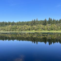
Poo Poo point is an amazingly beautiful trail in the West Tiger Mountains Trails. The view from the top is outstanding and can be chilly depending on the day and time of year. The trail is fairly wide and varies in terrain. Taking the long way up to Poo Poo point, which is a small trailhead by Issaquah High School, and you have a much quieter route. Approximately 3 miles to the top, across a couple bridges and a few switch backs. Also, possible bear sightings on this route. Wear a bear or carry pepper spray, which I do. Once at the top you bc an either go down the front or back the way you came. I took the trail downhill and dang. It was super steep. Like ridiculously steep. If you decide to take the popular crowded way be prepared for crowds on a single lane trail covered in boulders. Also, very steep and plenty of switchbacks. Stay hydrated and happy trails. SYOY. read more


2 years ago
Another great hike here. I've been doing this hike for years. In all four seasons. I call it a trainer hike. It definitely not for the a beginner hiker. Beginning is a steep climb. So pace yourself. Watch where you are stepping, lots of stones and rocks. Stones can get slippery in rain and dusty weather. Easily located right off a road. Parking lot gets full quickly, so arrive early. read more


2 years ago
What a great hike. Beautiful scenery and nothing is too strenuous. The switchbacks made climbing the hill less laborious. It is a good 4 miles each direction, but it was so much fun. read more


5 years ago
Great hike! We recently hiked Poo Poo Point on an early Saturday morning and really enjoyed it! We had heard from multiple people the parking lot filled up quickly so we arrived early, about 7:30 am and, surprisingly, we still only got one of a couple parking spots remaining at that hour. Make sure to have a lot of water and a light snack that you can enjoy once at the peak. The terrain is fairly steep and rocky but the trail has been built with the assistance of the rocks, with many spots having stairs built out of rocks. It took us about 2 hours, at a leisurely pace, to get to the very top where we enjoyed a light snack and spectacular views. The hike itself was a pretty steep incline; at times, its like you were on a StairMaster, just walking up flights of stairs with no end in sight. Once you're at the top, you have a beautiful view of Mount Rainier. I really enjoy this hike! I recommend coming early. It's a very busy trailhead with limited parking. They also have a paragliding spot at the top. There is a beautiful view of Mt Rainer close to the top. The view is incredible and loved watching the paragliders take off! read more


2 years ago
4 years ago
This is not a hike for beginners... It's a very steep mountain and is full of steps to go up. I went to the top and it was hard ( and I am used to hike ....) Going down the mountain is harder .... The trail is very narrow so u have to stop and let people pass which is ok so you can catch ur breath lol I highly recommend this hike but be prepared to a hard hike that will kick ur ass big time lol Its worthy to see the wonderful views of Mount Rainier and lake Samamish . Have a great hike ! read more


8 years ago
The trailhead is off of the I-90 Front Street exit in Issaquah. You can't beat the convenience to Seattle if that's where you're coming from. I arrived at 830am on a Saturday and the parking lot was full. There is a property just before the parking lot that has about 80 parking spaces and they charges $5. Cash only. There is also no change available so just be ready, it's just somebody's personal property. The trail begins with a sign that says Chirico Trail, but it leads to Poo Poo Point. Immediately, your climb begins and it feels like it doesn't end. I believe it's around 3.8 miles round trip with 1900 feet elevation gain. It felt longer going up. I've recently done little si and rattlesnake and for some reason this one just had me winded within 20 mins of the hike. There are a lot of medium sized rocks on this trailhead and there's no real section of easy hiking to the top. Once you get to the top there's an opening where you can see Mt. Rainier. You'll then continue another 1/4 mile to Poo Poo Point with views of downtown Bellevue and lake sammamish. If you're lucky you'll get to watch paragliders or parachutes take off from the top. There's plenty of space and picnic tables at the top to have lunch and relax. read more

8 years ago
This is based on the Chirico trail, I LOVE THIS HIKE. Note: I havent gone intense hiking in a long time- newbie Suprisingly I got parking in the small lot at 11:20 fter waiting 10 minutes on a Saturday. There is a high school and park down the road with plenty of space, but there are people who choose to recieve a 20 dollar fine parking along the two way road. For years this has caused safety concerns, but I learned on Komo 5 News they cant extend parking because of protected land. When starting the hike I didnt know what I was facing so I overpacked for a 3.4 round trip hike. Starting the actual trail there are a whole bunch of rocks with a narrow path so please be careful and aware of other hikers. The incline was a killer on my calves. The other hikers were so supportive/nice. The top is worth the hour, I arrived at 12:30 and stayed for 40 minutes. I heard there is more of a hike to see people paragliding/hangliding and I am for sure going to see this on my next hike here. Then I left, on the way down is a breeze. I aboslutely love this place in Issaquah. There are a ton of dogs and runners, its crazy how they can workout through this incline. read more


4 years ago
gonna be honest--this was 10x harder than I thought it was going to be. i mean i wouldn't consider myself an advanced hiker but i have done quite a few hikes in my day. this was hard. steep and long. but at the same time, worth it. felt good to get to the top. overall, i recommend; just know what you're getting in for. read more

After driving in circles and asking two different people for directions, I found the trail head. The first guy steered me wrong and I ended up on the Rainier Trail across the street. The guy I met on that path steered me right and described the entire hike for me, which left me slightly terrified but grateful to not be driving in circles anymore. The entrance to Poo Poo Point is literally between parked cars in a neighborhood by the high school. Like entering Narnia only with less outerwear. The second guy told me, "just keep going right" once on the trail and he was spot on. I often marvel at how easy some people make hiking look. As an amateur hiker I'm still building up my endurance, and am the red-faced sweaty mouth-breather waiting for you to pass. This is the second solo hike I've done in recent weeks and this one definitely left me with noodle legs. I exclaimed to a group of hikers on their way down (when I was about halfway up), "You're still alive! That's good." To which one responded, "Yeah, but it only gets harder from here." I was like, "Are you kidding me?!" He wasn't kidding me. It took me just under two hours to reach the summit and I almost gave up. My reward for pushing through the pain was a front row seat to paragliders launching off the side of Tiger Mountain. What a sight! My muscles were sore for three days, but I appreciated the wooded covering during the hike and the sweet sounds of birds and breeze in the trees. Lots of moss and wildflowers and a panoramic view at the top. I will pace myself better this month, but hope to come back to Poo Poo Point when I'm feeling a bit more dangerous. Parking is limited, so find a spot at the high school and walk over to the entrance. If you see the well-marked Rainier Trail Park sign, cross the street to Narnia. read more


4 years ago
Hike is very hard, all uphill and we had to stop quite a few times, but it was totally worth it! The view at the top was amazing! read more

6 years ago
Being a 20 minute drive from Seattle, you really can't ask for more! Beautiful moss covered trees, challenging yet not too strenuous elevation gain, and then a few extremely rewarding look out spots from the top! You can see in just about every direction, which is pretty awesome! High point to recognize, being so close to civilization, this is a very popular hike on a nice weekend. So go on a week day if you want a slightly more serene hike. read more


9 years ago
PooPoo Point is fun to say! Lol (real mature, right? Haha) but anyway! 2 of my cousins and I hiked this for the first time, and I've been wanting to hike this again! It was pretty killer! I do cardio almost every day but when you add some sort of elevation... OoOowee!! I jogged up for a 1/2 mile going up some "rock stairs" I had a good momentum going for me. - Took me 4.5 hours round trip, we of course took some pictures, ate lunch. Once you reach a vast grassy area with a view you know, you have reached the top of the hill. However, there's another trail entrance I think another 1.5 miles up - DO IT! much more worth it. The top of the higher elevation is where they para-glide. read more

I read in several different places that this trail is considered moderate. If this is moderate I'd hate to see what difficult is! This trail is an agonizing 4.1 mile uphill hike, one way. Those who call it moderate are in a hell of a lot better shape than I'm in and I wouldn't necessarily say I'm out of shape but this was HARD! It took us about 3 hours to make it to the top and that was with many rest stops. The way down was definitely faster but not necessarily a lot easier. The view at the top was really nice. The weather was great so there were a lot of para gliders launching. It was so neat to watch. I had pictured myself getting to the top and finding a nice patch of grass to doze in for 30 minutes or so, but there aren't a lot of grassy patches there that are conducive to napping. It was beautiful for sure, but worth the agony? I'm not sure. I definitely don't see myself doing it again. I also find myself enjoying hikes that have more scenery throughout not just at the top. There was definitely not a lot to see on this hike but trees. We were pretty sore for about two days after. Best place to begin the trail is at the Issaquah high school were parking is free and plentiful (at least on the weekend). From the high school it's 4.1 miles to the top. Make sure you bring plenty of water and snacks. Water is an absolute must! There is a bathroom at the top but it's hell. It's environmental friendly because it's chemical free but that means it's not human being friendly. There is another trail down the road about a mile from the high school called poo poo point Chirico trail. It's really busy and hard to find parking. I was told it's a shorter way to the top but that it's steeper. read more


7 years ago
Entrance is right off of 2nd ave SE. parking is a small dirt lot made for about 4-5 cars. look for a sign that says 1 in blue labeled at west tiger mountain trails at the trail head. Beautiful views at the top. read more


4 years ago
8 years ago
First time traveling to Seattle and we needed a little exercise. A friend recommended this trail and it was a great hike! The entrance doesn't appear on the map app well and it's entrance says The Chirico Trail, but it's the Poo Poo Trail. Takes you to the top of Poo Poo Point which was so beautiful. Well worth the hike up to see. The path is paved with a lot of rock but I believe this prevents erosion. Would definitely recommend. read more


7 years ago
7 years ago
7 years ago
7 years ago
9 years ago
7 years ago
7 years ago
9 years ago
9 years ago
7 years ago
7 years ago
7 years ago
8 years ago
More info about Poo Poo Point
706-732 2nd Ave SE
Issaquah, WA 98027
Directions
Hours
Indoor Amenities
Outdoor Amenities
Ask the Community - Poo Poo Point
Review Highlights - Poo Poo Point
You might also consider


Why does Yelp recommend reviews?
6 reviews that are not currently recommended
The reviews below are not factored into the business's overall star rating.
5 years ago
4 years ago
2 years ago
3 years ago
3 years ago
9 years ago
Poo Poo Point - hiking - Updated May 2026
Best of Issaquah
People found Poo Poo Point by searching for…
Beautiful Views in Issaquah, Washington
Places to Take Pictures in Issaquah, Washington
Stairs Workout in Issaquah, Washington
Paved Walking Trails in Issaquah, Washington
Easy Hiking Trails in Issaquah, Washington
Picnic Spots in Issaquah, Washington
View Points in Issaquah, Washington
Things to Do With Kids in Issaquah, Washington
Dog Friendly Parks in Issaquah, Washington
Scenic Overlook in Issaquah, Washington
Lookout Points in Issaquah, Washington
Fishing Spots in Issaquah, Washington
Fun Things to Do in Issaquah, Washington
Hiking Trails With Waterfalls in Issaquah, Washington
Natural Hot Springs in Issaquah, Washington
Walking Groups in Issaquah, Washington
Parks for Kids in Issaquah, Washington
Running Stairs in Issaquah, Washington
Kid Friendly Hiking Trails in Issaquah, Washington
Hiking With Kids in Issaquah, Washington
Trending Searches in Issaquah, WA
Botanical Gardens near Poo Poo Point
Bounce House Rentals near Poo Poo Point
Campgrounds near Poo Poo Point
Cherry Picking near Poo Poo Point
Cliff Jumping near Poo Poo Point
Floral Designers near Poo Poo Point
Flower Fields near Poo Poo Point
Flower Shop near Poo Poo Point
Garage Sales near Poo Poo Point
Garden Center near Poo Poo Point
Lakes & Ponds near Poo Poo Point
Nurseries & Gardening near Poo Poo Point
Outdoor Activities near Poo Poo Point
Outdoor Furniture Stores near Poo Poo Point
Party Equipment Rentals near Poo Poo Point
Photo Spots near Poo Poo Point
Picnic Areas near Poo Poo Point
Places To Take Pictures near Poo Poo Point
Plant Nursery near Poo Poo Point
Rock Quarry near Poo Poo Point
Running Trails near Poo Poo Point
Scenic Drive near Poo Poo Point
Scenic Night View near Poo Poo Point
Sunrise View near Poo Poo Point
Swimming Holes near Poo Poo Point
Browse Articles
Browse Nearby
BEST of Issaquah, Washington Restaurants near Poo Poo Point
BEST of Issaquah, Washington Coffee near Poo Poo Point
BEST of Issaquah, Washington Things to Do near Poo Poo Point
BEST of Issaquah, Washington Breakfast near Poo Poo Point
BEST of Issaquah, Washington Parks near Poo Poo Point
BEST of Issaquah, Washington Horseback Riding near Poo Poo Point
Browse Brands
Related Searches in Issaquah, WA
Affordable Kayak Rental Services in Issaquah, Washington
Best Fishing Locations and Guides in Issaquah, Washington
Best Places for Horseback Riding in Issaquah, Washington
Best Waterfalls and Swimming Holes in Issaquah, Washington
Check Out Off Road Trails in Issaquah, Washington
Discover Dog Friendly Trails to Explore in Issaquah, Washington
Discover Kid Friendly Hiking Trails in Issaquah, Washington
Discover Scenic Mountain Bike Trails Near Issaquah, Washington
Discover Scenic Walking Paths in Issaquah, Washington, {State}
Discover Scenic Waterfall Spots in Issaquah, Washington
Discover Top Nature Parks to Visit in Issaquah, Washington
Discover Top State Parks to Visit in Issaquah, Washington
Discover a Hiking Trail in Issaquah, Washington
Discover the Best Night Hike Trails in Issaquah, Washington
Discover the Breathtaking Waterfall Trail in Issaquah, Washington, {State}
Dog-Friendly Hikes With Dogs in Issaquah, Washington
Enjoy Camping Adventures Around Issaquah, Washington
Enjoy Exciting Mountain Biking Adventures in Issaquah, Washington
Enjoy Kayaking Adventures in Issaquah, Washington
Enjoy Tent Camping Spots Around Issaquah, Washington
Enjoy a Beautiful Waterfall Hike in Issaquah, Washington
Enjoy a Scenic Walk in Issaquah, Washington, {State}
Enjoy the Best Picnic Spots and Ideas in Issaquah, Washington
Enjoy the Best Walking Trails in Issaquah, Washington
Experience Thrilling White Water Rafting in Issaquah, Washington
Explore Beautiful Parks and Green Spaces in Issaquah, Washington
Explore Easy Hikes Perfect for All in Issaquah, Washington
Explore Fun Activities to Do in Issaquah, Washington
Explore Popular Campgrounds Near Issaquah, Washington
Explore the Best Beach Spots in Issaquah, Washington
Explore the Best Swimming Holes Around Issaquah, Washington
Explore the Best Trail Options in Issaquah, Washington
Family Friendly Hiking With Kids in Issaquah, Washington
Find Beautiful Views in Issaquah, Washington
Find Popular Ziplining Spots Around Issaquah, Washington
Find the Best Parks for Picnics in Issaquah, Washington
Find the Best Scenic View Locations in Issaquah, Washington
Hiking Trails With Waterfalls in Issaquah, Washington
Off Leash Dog Hiking Trails in Issaquah, Washington
Plan a Scenic Drive Route Near Issaquah, Washington
Popular Outdoor Activities to Try in Issaquah, Washington
Popular Picnic Spots to Visit in Issaquah, Washington
Safe River Swimming Areas in Issaquah, Washington
Safe and Fun Parks for Kids in Issaquah, Washington
Top Climbing Spots and Gyms in Issaquah, Washington
Top Running Trails to Explore in Issaquah, Washington
Top Swimming Lakes to Enjoy in Issaquah, Washington
Top Swimming Spots and Pools in Issaquah, Washington
People who viewed Poo Poo Point also viewed
Poo Poo Point - Chirico Trail
166 reviews
Rattlesnake Ledge Trail
214 reviews
Paradise Valley Recreation Area
3 reviews
Evans Creek Preserve
23 reviews
Big Creek Falls - Taylor River Trail
3 reviews
Cherry Creek Falls Trail
42 reviews
Snoqualmie Point Park
18 reviews
Gold Creek County Park
2 reviews
Squak Mountain State Park
22 reviews
Beaver Lake Park
22 reviews