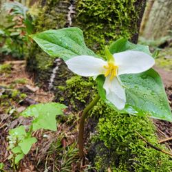
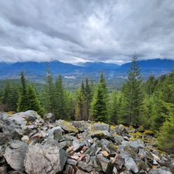
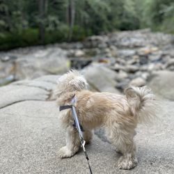
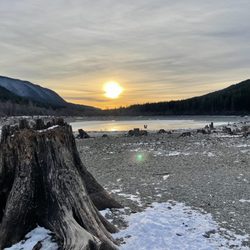
Mount Si Photos


You might also consider
More like Mount Si
Recommended Reviews - Mount Si
Start your review...

Reviews With Photos

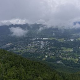
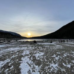
It's a strenuous hike. Be prepared to sweat baby, sweat. It's been on my bucket list for awhile and am finally happy to say that I've summited Mount Si. Wake up early and go! I woke up around 5:30am, arrived from Bellevue to North Bend at 6am, and there were already a handful of cars. The parking lot is larger than other trailhead parking lots around, but it gets full. It's also further down the Little Si parking lot, with signs indicating where to go. By the time I left there were cars circling around, stalking those hikers who were on their way out. Get here early, peeps! Also, be careful when you arrive to the parking lot because the gravel road was fulllll of potholes. Go slow and steady. I'd recommend driving a vehicle with AWD, as some of the potholes were really deep. Discover Pass is required. The hike is about four miles up, so eight miles roundtrip. It's strenuous in that, it's long. It especially feels like it when you're going on steeper inclines, but the trail is very well-managed. It's also much wider than other trails in the area, making it possible to socially distance from one another. The hike will have you trek through the forest much of the time, to help keep cool. There were also areas with benches where you can stop and take a break. When you're near the summit, there's a map that shows you're only 0.3 miles away from the top. There, you will end up scrambling as the area is all rock form. It's a pretty easy climb. The challenge will be for those going to Haystack Rock, which is the true summit of this hike. The views of Mount Rainier and the Snoqualmie Valley area are what you'll see first once you reach the top. But if you go back towards Haystack Rock, there's another viewpoint where you can see the Bellevue area. Many people took a break around the rocks to eat and enjoy the sights. This was an awesome hike that had my knees and feet sore! Going up was hard because it's a workout, but going down was actually harder for me because of how bad my knees and feet felt. I would recommend bringing hiking poles if you have 'em. Other than being sore the next day, it was a rewarding challenge and would recommend anyone wanting a good, long hike to check out Mount Si.

Just got back home from the hardest hike I've ever done. Started off my hike at 545am. There was already one person ahead of me and one person behind me. Definitely recommend waking up early for the hike. Discovery pass required. I ordered online but my pass never came so I just wrote down the transaction and enforcement # and placed it on my dash. I had no problems with that. Now the hike..... I started off at the Mount Si parking lot. Kept walking up very steep incline (30-45 degree it seemed like) for maybe 1 mile+ straight. Then there's a bit of downhill for a while and then more uphill climb. I don't know where I went wrong but I eventually ended up to the sign where it tells me that I have 0.3 miles to go till I reach the top. Unfortunately the snow had covered most of the trail and was very obscured. By the time I noticed that I was wandering aimlessly, following what looked like foot steps to me, I was in the middle of nowhere with no trail in sight. I WAS LOST Luckily a very nice gentleman named Chris was just 100ft from me so I yelled out for help. I climbed rocks and eventually got to where he was standing. We both attempted to find the trail to the overlook but unfortunately we both decided that it was not safe so we turned back around. If it wasn't for Chris I would have had a very difficult time even finding my way back down. On my way down I was once again hiking solo and wandered all the way to the Teneriffee parking lot. I asked the very nice couple standing by the entrance where I was and they said I was about 1 mile away from Mount Si parking lot. I nearly cried. But the nice lady, Penny drove me back and all is well. My bad knees are in pain. So confused as to how people are saying this hike is only 8 miles when I'm sure I did like 13 miles with 35,0000 steps logged on my fitness watch. If someone knew what I did please let me know lol. As someone who is a first timer hiking this particular hike and hiking it solo... I don't recommend. But I give it five stars because it was beautiful. I just wish that I could have finished the hike.
Came on a Saturday morning around 10AM, parking lot had many cars but lots of space, rainy cloudy day though that was forecasted to rain. Path was steadily uphill but not too steep, pretty narrow though. Thankfully not too many people on the trails. Views at the top were just okay since the rain clouds were covering a lot of the view. Having stayed up there for a bit, the clouds moved away and more of the view came out. Not too crowded at the top, and the way down was fine too. It started raining a lot more and got a bit cold. Good hike, but probably wait for good weather!

Beautiful hike for the able bodied. This is well worth the effort and the difficulty level is on the far end of moderate. Stunning views from the top! Parking at the trail head is ample and there is a convenient pit toilet for services. Pretty breezy above the tree line, definitely dress in layers for the transition in and out of the wood line in the colder months. Check the weather report and prepare for snowy/icy conditions for the final leg at the top during the winter. Didn't see any sign or wildlife as this trail appears to be regularly frequented. All in all, another breathtaking sight of everything to love about the PNW.


!!WARNING!! This hike is not for first time goes. Having said that, we had a really great time. For things to know before you go scroll down to the * Our group ranged from 18-45 y/o, with both male n females. The trek up is a workout on your legs, recommend taking a walking stick and at least 1-2 quarts of water and snacks. The trail keeps going up from the start to the top. It's a lil over 4 miles & some change up and believe me after mile 2 you really feel it, but once you hit 3.5 you can almost taste the top. Be sure to take rest breaks along the way and you'll be GTG. Our group didn't take any breaks bc we're all hard chargers, but if I was taking my fam, yeah we would have stopped n rested intermittently. Dogs are welcome, but please don't leave the poop bags on the trail. I seen a hiker with a Dodson and thought...Y you doing that to them? This is more for large to medium size dogs, small ones might injure themselves. If you take your puppers bring them water n something to eat too, they will be eternally grateful The trip down was the best feeling! Having worked so hard going up, I dang near jogged the whole way down. Some parts be careful, but you'll see the tricky steps. After all was said n done we chilled in the parking lot and enjoyed the day. *Skill lvl 4 hike, mostly incline Parking lot requires Discovery pass.(might be able to get a temp pass if ranger is there) Lots of potholes in the parking lot Don't leave valuables/electronics in cars Bring 1-2 quarts of water n snacks Walking stick recommend LRG-MED dogs, may not be suitable 4 small dogs Take breaks, and clean-up after yourself Dress in layers n bring a backpack to downgrade as needed Bathroom is only at the base n you might need a gas mask

This hikes is easily accessible and just a couple minutes from the freeway exit! It was refreshing to not have to drive a whole bunch of switchbacks to get to a trailhead. From Kent, it's a quick 45 minute drive. In order to park in the lot, you have to have a discovery pass, which you can buy online and print at home for $11.50. Make sure you do this before going to the hike because there isn't a ranger there who sells the discovery pass. The hike is pretty much completely shaded the entire time except for the summit. You're surround by the beautiful Washington woods. It's a major workout! You're going uphill pretty much the entire time. You climb over 4,000 ft in elevation in just 4 miles. It took my boyfriend and 2 hours to the top and and hour and 40 minutes to the bottom. The view at the top is worth all the hard work! The birds at the summit are so cute and friendly too. They were landing on our hands and feet!

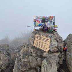
This climb is so killer. The 4 miles in is entirely uphill and enclosed by trees, so there isn't much to focus on except for the undeniable pain in your quads that slowly starts to creep in. But, if you can get past that pain and keep moving one foot in front of the other, eventually you'll reach the top, and boy, is that view something else. It is so gratifying when you finally get to the top. It was a clear day when I went, and I could see all the way to Seattle. There was a bit more climbing to do on a rocky surface to get to a better viewing area however. That was definitely worth the climb because you got more of a 360-view with tons of photo opportunities. From this peak there was also access to higher mountain peak, but from what I gathered it was an almost vertical scaling of the mountain side with fewer safety features and many posted "caution" signs. I wouldn't say I'm scared of heights really, but extreme heights and a lack of security tends to make my palms sweaty. So I was happy staying on the lower, safer peak! After you take in the view, get your pictures in, and catch your breath, enjoy the 4-mile return trip downhill. If my college anatomy course taught me anything, though, it's the downhill portion of a hike that will make you sore the next day. :D

For two "hikers" this one is a must try once. We haven't hiked in at least a year and heard mixed reviews on level of difficulty. It's a constant upward hike with very few flat parts. We brought 5 bottles of water for two and went through almost all of them on the way up. It goes through mostly wooded areas with limited sun so being light layers you can shed as needed. Wear good shoes and bring snacks. Most importantly take your time and feel free to take breaks if it gets a bit much. The view at the very top is worth it.

This hike is as challenging as everyone makes it out to be. It's a steep hike, and the scenery on the way to the top is a bit boring. But once you make it to the top, you'll realize that the dud scenery and heavy panting was all worth it. At the top the view is absolutely stunning; great views of mountains and there are a lot of colorful plants as well. It's also a rock-climber's paradise. I don't have much climbing experience, but there are a lot of opportunities to climb around. I wanted to climb to the top of this one lookout point, but given that I was hiking by myself and given that I don't have much experience climbing, I didn't think it was the wisest idea. I made it about halfway up and decided to stop. I probably could've made it to the top but it was very steep and I began thinking, "I may be able to make it to the top, but how am I going to get down?" I hiked this three times last summer, once when it was foggy and twice when it was clearer. I enjoyed the hike all three times. Just make sure that you eat enough beforehand and bring enough water and snacks for the trek.

Extra star to King County for the excellent direct-to-trailhead bus service - a truly great service to the community that serves multiple goals (less traffic! easier access to hikes!). I was impressed by the number and diversity of people I saw using this service. Thanks King County! As for the trail itself, eh. Pros: The payoff was pretty fantastic, and it sure is a good workout. It's under tree cover the whole time too, so it stays a comfortable temperature. Big con: the scenery does. not. change the entire hike. 4+ hours of looking at the same thing all the way up and down. This hike is really more about the destination than the journey. I prefer hikes that hold your interest throughout. This hike is worth doing, but it's not a must-do, especially if you're looking for more than just a workout.


Round Trip: 8.0 miles Difficulty: Moderate - Difficult Discover Pass Required I started the hike on a Saturday morning. I arrived at 8 am and there were about 40 cars in the parking lot. We finished around 12:30 pm. There were a lot of people on the trail on a weekend. Morning weather started out around 60 degrees and by the time noon hit, it was 80 degrees. I wore hiking shoes, dry fit, and brought my hiking poles. My friends that came with me mentioned they wish they wore hiking shoes. The trail is mainly in the shade. The last part of the trail is steep. At the top you can get a great view of Mt Rainier on a sunny day. I highly recommend hiking poles, it is useful on the way down. The friends I went with were complaining about their knees and ended up wearing knee bands. Overall the trail is moderate to difficult. I recommend coming early to start the hike since weekends are a popular time. Good luck!

14 years ago


9 years ago
Incredible view at the top. I'm moderately fit (for reference, it takes me about 40 min without a break to hike rattlesnake) and this hike took me 1 hour 45 min to snoqualmie viewpoint. Probably would have taken me another 15 min to hike the haystack at the end, but chickened out because I'm scared of height. Take it easy on the way down -- the other reviews are on-point about the harshness on the knees! read more

12 years ago
15 years ago
10 years ago
12 years ago
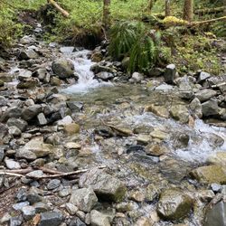
8.0 miles (round trip) of panting and whining. LOL.... Seriously, my boy and I are relative newcomers in the hiking arena. As a duo, we've only hiked one other mountain - Stawamus Chief in Squamish, BC. That was grueling, yet incredibly fun (vertical stairs, chains, ladder and a granite monolith.... say what?!?!). I digress. Mount Si is located in the bowel of North Bend. It took us about an hour to get there. Once we found the entrance, I cringed as I had to drive over rocks and dirt road to get to the parking lot. We went on a Wednesday so it was not that busy. Before embarking on the hike, we decided to pee. The stench that emanated from the restroom was god awful. Sh*t was splattered around the brim of the toilet and cascading to the side. A sight that I do not want to see ever again. On to the hike. It was smooth sailing at first. There is a bridge with a stream right below. A great place for selfie whores such as myself. LOL..... After that, you will come up on an intersection (left or right). We did not know where to go. Luckily, an experienced hiker directed us to the right path. The walkway got super narrow at certain points with lush vegetation within arm's reach. I freaked myself out as I thought a mountain lion or bear would jump out of nowhere and pounce on me. Nonetheless, the first half of the trail was relatively easy. We were taking it all in; making videos with our GoPro and cheesing for our Instagram fans. Haha...... Then, the hike got brutal. It was like increasing the difficulty level ten-fold on a stair master. It was a vertical trek up into Lord of the Rings terrain. Trees towered above us with rays of sunlight striking through the forest. Ubiquitous spider webs were intricately woven. Bushes shook out of the blue. We were determined so my boy and I huffed and puffed through endless switchbacks. After 3.5 hours, we made it to the apex of the trail. It was a sight to behold. I believe we could see the Cascades in the distance with the city of North Bend right below. As we munched on our goodies, chipmunks came out of their burrows and encroached into our personal space. I must have screamed like a b*tch getting f*cked in prison. Thankfully, no one was around to laugh hysterically. We, then, climbed the not-so imposing haystack. It is actually not as daunting in person as it is via Youtube. The panoramic view was magnificent. Sublime to say the least. Watch out, a huge m*tha effin rat came out of his cubby hole and almost helped himself to our bag of chips. See pics. Anyhoot, the summit is somewhat dangerous. Be careful and wear good shoes. I hurt my left knee maneuvering my way down the haystack. After an hour of basking in the sun and taking pictures, we descended down the trail. With a bum knee, we trekked slower than a snail crossing the street. It took us 3 hours just to get to the parking lot. Advanced hikers zipped down (one in slippers) the mountain like Usain Bolt blazing through the 100m dash. Oh, to be 20 again. Sigh! All in all, Mount Si gets my stamp of approval. Although it was arduous and frightening at certain points, the beauty you encounter on the trail and at the very top, is all worth it. **Bring a hiking stick and enough water to last you through the whole way.** read more


11 years ago
DISCLAIMER: I'm a regular/moderately experienced day hiker in the PNW, I average 5-10 day hikes in a year for the past 6-7 years, with 4-8 miles/hike being my sweet spot. I'm not a backpacker or avid outdoorsman by any means, although I do race in marathons and am a regular runner. BACKGROUND: Having been to many of the iconic hikes in the area, the one I've never done until today was Mount Si. It was such a perfect day on a Tuesday that I had off, so I drove out a bit later in the morning and arrived at the lot around 11am. Slightly chilly at 60F at the base (50F @ the top according to my Garmin) and overcast with the occasional sunbreak. Having heard a bunch of my friends and seeing a bunch of WTA reviews saying how hard it is with no payoff until you get to the summit (reminds me of mailbox peak), I was prepared to put my head down and grind it out (exactly like how I completed mailbox peak, twice). Also, because on my training schedule it showed I had a 6-8 mile run today, I decided to do trail running for the first time (I loosely use that term as I mostly just power walked the entire time). THE HIKE: In the first 30 seconds, easy! At 31 seconds, I started gasping for air. This panting like a dog lasted the entire way up as I jumped, shimmied, sprinted, jogged, and walked my way up, scaring canines and hikers alike with my labored breathing and haggard hiking style, until I reached the rock scramble. Nothing extraordinary along the path to talk about on the way up. The top view was amazingly clear, with beautiful fall colors starting to come through, and it wasn't chock full of other hikers like reviews say it is on a weekend. There were maybe 10 cars total in the parking lot when I started up. Watch out for the birds though as they will steal food from your hands/bag! Please do not feed them - they are wild and will need to learn to fend for themselves especially with the coming winter. My Garmin gets lost in the woods easily and claims only 7 miles over 3,100' of climbing although WTA states it's a 8 mile RT. It's all relentlessly uphill except for a tiny 50-100 yard stretch near the halfway mark where it flattens out. EQUIPMENT: **THE PARKING LOT REQUIRES A DISCOVER PASS** I carried a little backpack with me with a water bladder, a little under 1L of water. Also a PBJ sandwich, TP (just in case), and a windbreaker jacket. I would recommend at least 2L water if you are hiking up at a slower pace and are not used to strenuous exercise, plus beef jerky or other protein sources to keep your stomach feeling satisfied during breaks. I would wear sturdy hiking shoes as there are areas on the trail that are very rocky and rooty, and some areas that had a mini-stream running in the middle of the trail. I didn't have trail running shoes and stupidly wore regular running shoes, thankfully I didn't twist any ankles or fall on the slippery way down. If you're a heavy sweater you may want to bring a small towel or hat and hang it off your backpack, it comes in handy! TIMING: In total it took me almost an hour to reach the haystack, although I didn't attempt to climb up it (too tired and afraid to fall). Took me about 40 minutes jogging down (took it slow - watch out for roots)! I read on here just as I'm writing this that people budget 2 hours; if you decide to walk and not run like I did - it seemed about right, as on my way down I passed some people still going up who I passed on my way up near the beginning of the trail. Weekdays are definitely good as there were maybe 10-15 parties that I saw the entire time. read more
 - Parks Near Me")
14 years ago
14 years ago
Mt. Si "Old Trail": A Different (Steeper) Way to Climb Mt. Si When I arrived at Mt. Si, I parked in the Little Si parking lot by accident (BTW, don't forget to buy a Discovery Pass!) At the trail head I met a couple who recommended I try the "Old Mt. Si Trail" which was replaced in the late 1970s by the current trail. I took the couple's advice and am now a convert. The old trail is shorter by about a mile which means it's steeper. But, it's also much quieter as very few hikers choose this trail. I saw only three other people on the trail going up and coming down. Here are some details to take this novel way up an old Seattle favorite: + Purchase a Discovery Pass! They're available at the North Bend Ace Hardware + Park at the Little Si main or overflow parking lots + Start up the Little Si trail head + Look for the Boulder Garden Loop trail sign, but stay on the main trail for now + When you see the 2nd sign for the Boulder Garden Loop trail (where it returns into the main trail), take a right into the Loop + When you reach the namesake boulders toward the top of the loop, look for a sign that says Boulder Garden Loop Trail with arrows pointing both ways + To the left of that sign is a path that heads pretty much straight uphill right next to a moss-covered small boulder (I've uploaded a picture of the sign) + Head up the trail and enjoy the peace and quiet of a beautiful natural preserve + Near the top of Mt. Si, you'll reconnect with the main trail for the final few hundred yards (make sure to remember where to turn off on to the old trail on the way down -- it's at a curve in the trail with a log across the old trail path) + Once you've taken your pictures at the top, take the old trail back down to your car in the Little Si parking lot + Get a professional massage the next day to soothe your sore thighs! It's a steep climb so bring plenty of water and snacks. Kids and dogs who are in shape and adventurous can definitely handle this hike. Have fun! read more

17 years ago
17 years ago
13 years ago
16 years ago

11 years ago
Life is good great trail to do on a wed morning.. The top view is amazing... Beautiful day read more

12 years ago
Mount Si is a must!! If you haven't done it...do it! I'd suggest going earlier in the morning before it gets super hot. We started out at 2:30pm (wasn't the best idea.) But it was great! It wasn't easy...at least for me. Let's just say I'm not in greatest shape ;) The last half of a mile kicked my butt, I was ready to start climbing on my hands and knees. But we made it! It was totally worth every bit of sweat! It is absolutely lot gorgeous at the top. Rocks are fun to climb...and you can get great shots up there. I totally enjoyed the whole experience. :) read more


11 years ago
Mount Si is conquered! But I never knew i could whine like that. (Hint) Bring plenty of fluids. Noticed a lot of people with just the clothes on their backs. It looked like they were suffering. Cover your food! a lady almost had her sandwich snatched out of her hands by a bird. So, uphill was a great conditioning battle. Downhill was brutal! by the time i got to the bottom my knees were jello and in pain. 24 hours later and I'm still sore. In the end i conquered Mount Si! I have pics to prove it! Been there done that wohoo!!! read more


14 years ago
11 years ago
Although I've hiked before, I've never had the pleasure to hike a "real" mountain. I'm rating this with no frame of reference/comparison to another mountain hike, but I can definitively say that I'd go back to Si and love to ascend it again. My friend had told me that his daughter and he had climbed it in 2hrs 18 minutes, so I had a goal... We made it in 1hr and 48 minutes. Needless to say, I can't comment much about the scenery on the way up, but thoroughly enjoyed the view from the peak and the scenery on the descent. One more thing to add, the trail was virtually spotless from litter. Boom. read more


16 years ago
13 years ago
Great hike, recommended. Took us 2.75 hours from parking to top of Haystack, 2 hours on the way back down. Not too bad if you've got enough water (2 nalgenes at least) and a lunch to eat at top. Crowded-ish, but parking wasn't a problem at 10am on Sunday. Haystack was cool, would recommend for any athletic person. Trail is very well maintained. Nowhere to go to the bathroom (except at trailhead). People say wear ankle support but I probably would wear trail shoes next time. This is not a stroll, but it's pretty straightforward -- up up and up! I used my poles, glad I did but it's discretionary. Worthwhile, fantastic views at summit, Seattle in distance. read more

15 years ago
16 years ago
10 years ago
9 years ago
Whewwwww! Thank god that's over with. Tough climb up there with nearly no breaks in the action, but couldn't be more worth it. I finally reached the top, or so I thought, and saw another peak ahead of me with a few lunatics even higher up. I called it quits there as the view couldn't get much better and I literally couldn't go up anymore. Worth the effort. The trail was a bit rocky at times and could definitely be slippery on the way down. Also, it gets a little chilly under the trees late afternoon. read more


This hike has been called the "Space Needle of Seattle area hikes". 36 miles from the city, it's near North Bend, WA. The trail is 8 miles out and back, and is somewhat challenging. It is usually crowded, being one of the most popular hikes around. We made a fun day of it, but I dont think I'll be back any time soon. There's a great view at the top, but I found the rest of the hike a little dull. For climbing enthusiasts, there's a vertical scramble at the top. Denny Creek Campground is the closest place to pitch a tent. read more


10 years ago
A nice novice/moderate hike to the half-summit and Moderate+ to the summit of Haystack. I saw a lot of people with Hiking boots, full backpacks, poles and REI accessories which to me seem completely unnecessary. My Advice: PACK LIGHT. Bring some water, and a granola bar. I made it up in under 1:30 and ran down in under an hour. You might enjoy some trail running shoes more than hot and heavy hiking boots - they aren't really needed on this very well-maintained trail. Just watch your step! read more

More info about Mount Si
North Bend, WA 98045
Directions
(360) 825-1631
Call Now
Visit Website
http://www.wta.org/go-hiking/hikes/mount-si
Hours
Indoor Amenities
Outdoor Amenities
Ask the Community - Mount Si
Review Highlights - Mount Si
You might also consider


Why does Yelp recommend reviews?
Mount Si - parks - Updated May 2026
Best of North Bend
People found Mount Si by searching for…
Hiking Trails With Waterfalls in North Bend, Washington
Scenic Drive in North Bend, Washington
Places to Take Pictures in North Bend, Washington
Dog Parks in North Bend, Washington
Campgrounds in North Bend, Washington
Things to Do in North Bend, Washington
Stairs Workout in North Bend, Washington
Scenic View in North Bend, Washington
Photo Spots in North Bend, Washington
Rock Climbing in North Bend, Washington
Playgrounds in North Bend, Washington
Parks With Pull Up Bars in North Bend, Washington
Scenic Spots in North Bend, Washington
Waterfalls and Swimming Holes in North Bend, Washington
Picnic Areas in North Bend, Washington
Fishing Spots in North Bend, Washington
Secret Spots in North Bend, Washington
Easy Hikes in North Bend, Washington
Tennis in North Bend, Washington
River Swimming in North Bend, Washington
Natural Hot Springs in North Bend, Washington
Stair Climbing in North Bend, Washington
Trending Searches in North Bend, WA
Botanical Gardens near Mount Si
Bounce House Rentals near Mount Si
Nurseries & Gardening near Mount Si
Off Leash Dog Parks near Mount Si
Outdoor Activities near Mount Si
Outdoor Basketball Courts near Mount Si
Outdoor Furniture Stores near Mount Si
Parks For Parties near Mount Si
Party Equipment Rentals near Mount Si
Places To Take Pictures For Prom near Mount Si
Public Running Track near Mount Si
Scenic Night View near Mount Si
Strawberry Picking near Mount Si
Browse Nearby
BEST of North Bend, Washington Restaurants near Mount Si
BEST of North Bend, Washington Coffee near Mount Si
BEST of North Bend, Washington Things to Do near Mount Si
BEST of North Bend, Washington Playgrounds near Mount Si
BEST of North Bend, Washington Picnic Areas near Mount Si
BEST of North Bend, Washington Breakfast near Mount Si
BEST of North Bend, Washington Caves near Mount Si
Browse Brands
Related Searches in North Bend, WA
Affordable Kayak Rental Services in North Bend, Washington
Best Fishing Locations and Guides in North Bend, Washington
Best Nature Trails for Hiking in North Bend, Washington
Best Off Leash Dog Parks in North Bend, Washington
Best Parks for Parties and Events in North Bend, Washington
Best Places for Horseback Riding in North Bend, Washington
Best Water Parks for Kids in North Bend, Washington
Check Out Great Playgrounds in North Bend, Washington
Check Out Off Road Trails in North Bend, Washington
Discover Baseball Fields Around North Bend, Washington
Discover Beautiful Garden Spots in North Bend, Washington
Discover Dog Friendly Trails to Explore in North Bend, Washington
Discover Fun Children's Playgrounds in North Bend, Washington, {State}
Discover Fun Toddler Parks in North Bend, Washington for Your Little One
Discover Lakes & Ponds to Explore in North Bend, Washington
Discover Popular Photo Spots in North Bend, Washington
Discover Scenic Mountain Bike Trails Near North Bend, Washington
Discover Scenic Walking Paths in North Bend, Washington, {State}
Discover Scenic Waterfall Spots in North Bend, Washington
Discover Soccer Fields in North Bend, Washington Near You
Discover Top Nature Parks to Visit in North Bend, Washington
Discover Top State Parks to Visit in North Bend, Washington
Discover Walking Parks in North Bend, Washington Near You
Discover a Hiking Trail in North Bend, Washington
Discover the Best Beaches in North Bend, Washington
Discover the Best Kids Park Spots in North Bend, Washington
Discover the Best Night Hike Trails in North Bend, Washington
Discover the Breathtaking Waterfall Trail in North Bend, Washington, {State}
Dog-Friendly Hikes With Dogs in North Bend, Washington
Enjoy Camping Adventures Around North Bend, Washington
Enjoy Exciting Mountain Biking Adventures in North Bend, Washington
Enjoy Kayaking Adventures in North Bend, Washington
Enjoy Tent Camping Spots Around North Bend, Washington
Enjoy a Beautiful Waterfall Hike in North Bend, Washington
Enjoy a Scenic Walk in North Bend, Washington, {State}
Enjoy the Best Picnic Spots and Ideas in North Bend, Washington
Enjoy the Best Walking Trails in North Bend, Washington
Experience Thrilling White Water Rafting in North Bend, Washington
Explore Beautiful Botanical Gardens in North Bend, Washington
Explore Beautiful Parks and Green Spaces in North Bend, Washington
Explore Easy Hikes Perfect for All in North Bend, Washington
Explore Family-Friendly Zoos and Wildlife in North Bend, Washington
Explore Free Picnic Areas Around North Bend, Washington
Explore Fun Activities to Do in North Bend, Washington
Explore Parks With Pull Up Bars in North Bend, Washington
Explore Popular Campgrounds Near North Bend, Washington
Explore Popular Picnic Areas Around North Bend, Washington
Explore Popular RV Parks Around North Bend, Washington
Browse Articles
People who viewed Mount Si also viewed
Little Si
106 reviews
Poo Poo Point - Chirico Trail
166 reviews
Twin Falls Trailhead
143 reviews
Bandera Mountain
13 reviews
Mt Washington Trail
10 reviews
Coal Creek Falls Trail
45 reviews
Cougar Mountain Regional Wildland Park
56 reviews
Lake Serene - Bridal Veil Falls
119 reviews
Bridle Trails State Park
40 reviews
Dirty Harry's Balcony
10 reviews