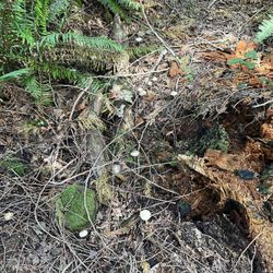
Tiger Mountain State Forest Photos


You might also consider
More like Tiger Mountain State Forest
Recommended Reviews - Tiger Mountain State Forest
Start your review...

Reviews With Photos

Woo there hikers !!! A place where you will be tested. A little over 3 miles up a steep ass hill, all uphill, to the summit view. Well we didn't make it up there but we did make it to the 2.70 point. Made the mistake of taking my older dog. Trails For pedestrians, bicyclists and horse riders. Lots of trail options. Our up and down was over 6 miles.
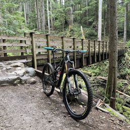
This is a special place for me. I'm an avid mountain biker and this place is special. If you are a hiker, just know you will pass a lot of bikers. Many mountain bike trails are down-hill only so you will get people going extremely fast, this is amazing for biking but I'd highly recommend staying off bike trails when you hike to avoid injury. Here is a list of some of the trails that I frequent: MasterLink - a climbing trail that gets you to the top (uphill only) OTG/NOTG - two different trails that parralell each other, both downhill Predator - highly technical downhill only EBAD - free ride-style technical descent Joy Ride Power Link Preston Railroad Northwest Timber Fully Rigid Extra Terrestrial


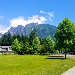
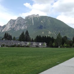
If you live in the Renton/Kent/Auburn/Federal Way area this is a fantastic, local trail for people who love hiking but don't want to drive three hours to do so. You do need a discovery pass to park up the mountain and I didn't find any place to go buy them. So if you don't have a pass, be sure to park at the very bottom entrance because you don't need one to park there. The main road/trail is nice and wide, but be careful because cars and bikers use the same road. You have to make sure you listen carefully and avoid them when they come. It might be a bit steep for little ankle-biters, but it's an awesome leg/butt workout. The view at the top of is pretty nice, lots of trees and hills. On a sunny day, you can see far out into Washington's forests/mountain ranges. I've only been there once so far, and I'm already craving to go back again. Definitely check it out!

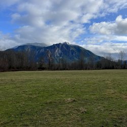
This is one of my favourite parks nearby to Seattle for a morning hike. I usually hike the northwest Timber trail for a nice rolling 5 mile out and back run in the morning to warm me up and stretch my legs. Big perk for me (being a frequent visitor but out of towner) is that there is a lower parking lot which does NOT require a WA Discover pass that makes so many great local parks inaccessible to me (a bugbear of mine about Washington is you can't just pay a day-fee). It's a quick hike to the trailhead from there. This trail offers great views of the valleys once you clear the first mile and a halts two wonderful overlooks where the timber was cleared in 2009 give a great look at the Cascades. It loses a star for only one reason, it's very close to 18 and only rarely do you make it far enough off the road to lose the roar of trucks. Lots of trails to explore here.

I'm injured so I'm only able to hike. The main MTB Logging road is steep but and enjoyable hike up to the the top of Tiger Mt. Where on a clear day it has wonderful views of My Rainer, it us an average of 7% grade just under 4 miles to the top. If you don't like that there are a few intermediate hikes with low elevation up the mountain. Try the Iverson(?) Trail, starting in the upper parking lot, its about a 2 mile trek one direction that has some ups and downs, but nothing to tricky. Kids could do it but not super little ones. Remember it is an out and back unless you decide to take the logging road back. There will be a sign pointing you in the right direction. The MTB trails stop there, but you can continue on up the road if that's what you are into. Either way enjoy!

I hiked up this today with a friend in the morning. It is a fairly easy hike - the path is extremely well kept and paved. The first mile is an incline but nothing too bad. The path is wide enough for two people to walk side by side and it is paved so you don't have to worry about rocky terrain. After this bit, the path evens out for awhile. Then you'll encounter some switchbacks. Was I out of breath? Yes. Was I dying? No. Once you're near the top, the trail narrows and becomes rocky. There are some steep drop offs so be careful. My friend didn't wear the proper shoes, slipped and nearly killed the both of us! There are some nice views around the stairs, good for picture taking. At the top, the trail evens out and you might be wondering where the viewpoint is at. Keep going and you'll find the clearing. It was freezing once we got there, after all, we were up 2500 feet. The view wasn't all that great today because it was a bit cloudy but we enjoyed it nonetheless. We stayed for a second and bolted down right after because it was so cold. All in all it took us about 3 hours, out of the car and back. I don't have too many pointers for this hike since most of the trail is not rocky by any means. However, if you plan on going up this anytime soon, wear layers. We started the hike wearing t-shirts and ended up having to wear a sweatshirt and a thin jacket on top of it. I also heard this trail gets packed on weekends so I'd suggest you come early or go on a weekday.


This is where I always go walking or hiking. They have a short little trail for light walking (moms can even bring their strollers). It's really beautiful and the perfect trail to show tourists. Then they have lots of longer trails that keep leading into other trails. My second time to Tiger Mountain, I went back to the forest and wanted to check out the other trails to see if I could find a better, more beautiful one to show my future house guests and I saw the most amazing things. I kept continuing from one trail on to the next and i saw forest, tall thickets, beautiful streams, etc. It was the most beautiful hike I'd ever been on.

3 years ago
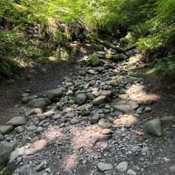
This review is for a hike in WA Mountain State Forest. Meeting friends for a hike on south tiger mountain loop in the tiger mountains. Still orientating myself with logistics here in WA. This hike was approximately 7 miles and beautiful! The forest here is absolutely gorgeous. Green trees and so many ferns. Super wet and foggy but not raining. Our trail destination was the south tiger mountain loop. I followed (and trusted, lol), my more experienced hiker friends with following signage. This, so many photos of signs. The trail had one muddy spot but the rest was easy to follow. Signage mentioned that horses share the trail but we didn't see any. The peak was very foggy so we didn't see anything. No restrooms anywhere that I could see. Parking, I followed AllTrails direction who h led me to park on the road. Beautiful forest! Can't wait to explore more. Happy Yelping. read more


4 years ago
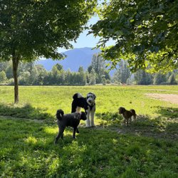
On our workation to Seattle, my partner's friend recommended Tiger Mountain as the most epic place to hike on the Saturday morning we had together. For this brief excursion, we parked at High Point Trailhead and did the West Tiger Trail #3 and Around the Lake Trail. I'm in absolute awe of this forest, especially knowing there's so much more to explore. I love looking at everyone else's photos of Tiger Mountain because there's some cool tree formations I want to check out. I'm obsessed with foot bridges, greenery, and lakes. It's notoriously intense, though. Other things I've read in reviews include only bringing active dogs and watching out for mountain bikers. Would totally come back to Washington just to explore more of Tiger Mountain. Beautiful chunk of nature. read more


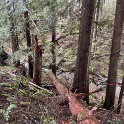
Just adding another fun adventurous trail on South Tiger mountain. Most of the the hike is in the beautiful woodlands, showing off a the well managed second and third generation forests, still a lot of relics of old nursery stumps from old growth forests. Hiking also through areas of recent harvest and clearing for power lines. Most shaded, but just enough sunlight throughout, that sunscreen is highly recommended. One part of the trail is almost impossible to navigate, the spur that takes you to the peak of South Tiger, due to many fallen trees over winter and bramble new growth, most of the trail is gone or unrecognizable, after trying to find a way, which didn't happen, I had lunch while sitting on some of the fallen trees, enjoyed some amazing views to the south and west, unfortunately at that time, Rainier was covered with clouds, but still great views. A great time to see tons of foxglove flowers in the clearings, lots of butterflies and bumblebee species throughout. The procession of wildflowers just keeps coming, with more about to start blossoming, being my first summer in Western Washington, as a horticulturalist, it's been very exciting to see, lots of new plants and animals to see. The salmon berry bushes are present throughout the trail and many are starting to ripen, like most berries, the best way to tell they're ripe and ready, is how easily they 'pop' off the stem. I've noticed some are really sweet, while others remain tart, depending on the amount of sun exposure. This is a fun, moderate trail, a few inclines, but none severe. A great way to get a 7 + mile hike in a beautiful area. Woods, wetlands, and lots of nature. As usual AllTrails mileage is a little off. Brings lots of water and snacks to stop and enjoy in this beautiful part of nature. Parking here is along the road, enough for at least 20 cars, trail is a little challenging to find, as it's on the opposite side of the road from parking. It's still so easy to get turned around, directionally, due to being new to the area and all the trees. Be patient with yourself and enjoy the journey. Happy Hiking and Yelping! God bless and Cheers! read more


Woo there hikers !!! A place where you will be tested. A little over 3 miles up a steep ass hill, all uphill, to the summit view. Well we didn't make it up there but we did make it to the 2.70 point. Made the mistake of taking my older dog. Trails For pedestrians, bicyclists and horse riders. Lots of trail options. Our up and down was over 6 miles. read more


This is a special place for me. I'm an avid mountain biker and this place is special. If you are a hiker, just know you will pass a lot of bikers. Many mountain bike trails are down-hill only so you will get people going extremely fast, this is amazing for biking but I'd highly recommend staying off bike trails when you hike to avoid injury. Here is a list of some of the trails that I frequent: MasterLink - a climbing trail that gets you to the top (uphill only) OTG/NOTG - two different trails that parralell each other, both downhill Predator - highly technical downhill only EBAD - free ride-style technical descent Joy Ride Power Link Preston Railroad Northwest Timber Fully Rigid Extra Terrestrial read more


5 years ago
Went to the Preston Trail, which said it was about 8miles round trip, but just did 4 miles round trip. It was 81 degrees and gorgeous clear skies so the hike in the forest was beautiful! read more


6 years ago
9 years ago
If you live in the Renton/Kent/Auburn/Federal Way area this is a fantastic, local trail for people who love hiking but don't want to drive three hours to do so. You do need a discovery pass to park up the mountain and I didn't find any place to go buy them. So if you don't have a pass, be sure to park at the very bottom entrance because you don't need one to park there. The main road/trail is nice and wide, but be careful because cars and bikers use the same road. You have to make sure you listen carefully and avoid them when they come. It might be a bit steep for little ankle-biters, but it's an awesome leg/butt workout. The view at the top of is pretty nice, lots of trees and hills. On a sunny day, you can see far out into Washington's forests/mountain ranges. I've only been there once so far, and I'm already craving to go back again. Definitely check it out! read more


This is one of my favourite parks nearby to Seattle for a morning hike. I usually hike the northwest Timber trail for a nice rolling 5 mile out and back run in the morning to warm me up and stretch my legs. Big perk for me (being a frequent visitor but out of towner) is that there is a lower parking lot which does NOT require a WA Discover pass that makes so many great local parks inaccessible to me (a bugbear of mine about Washington is you can't just pay a day-fee). It's a quick hike to the trailhead from there. This trail offers great views of the valleys once you clear the first mile and a halts two wonderful overlooks where the timber was cleared in 2009 give a great look at the Cascades. It loses a star for only one reason, it's very close to 18 and only rarely do you make it far enough off the road to lose the roar of trucks. Lots of trails to explore here. read more


11 years ago
I'm injured so I'm only able to hike. The main MTB Logging road is steep but and enjoyable hike up to the the top of Tiger Mt. Where on a clear day it has wonderful views of My Rainer, it us an average of 7% grade just under 4 miles to the top. If you don't like that there are a few intermediate hikes with low elevation up the mountain. Try the Iverson(?) Trail, starting in the upper parking lot, its about a 2 mile trek one direction that has some ups and downs, but nothing to tricky. Kids could do it but not super little ones. Remember it is an out and back unless you decide to take the logging road back. There will be a sign pointing you in the right direction. The MTB trails stop there, but you can continue on up the road if that's what you are into. Either way enjoy! read more


I hiked up this today with a friend in the morning. It is a fairly easy hike - the path is extremely well kept and paved. The first mile is an incline but nothing too bad. The path is wide enough for two people to walk side by side and it is paved so you don't have to worry about rocky terrain. After this bit, the path evens out for awhile. Then you'll encounter some switchbacks. Was I out of breath? Yes. Was I dying? No. Once you're near the top, the trail narrows and becomes rocky. There are some steep drop offs so be careful. My friend didn't wear the proper shoes, slipped and nearly killed the both of us! There are some nice views around the stairs, good for picture taking. At the top, the trail evens out and you might be wondering where the viewpoint is at. Keep going and you'll find the clearing. It was freezing once we got there, after all, we were up 2500 feet. The view wasn't all that great today because it was a bit cloudy but we enjoyed it nonetheless. We stayed for a second and bolted down right after because it was so cold. All in all it took us about 3 hours, out of the car and back. I don't have too many pointers for this hike since most of the trail is not rocky by any means. However, if you plan on going up this anytime soon, wear layers. We started the hike wearing t-shirts and ended up having to wear a sweatshirt and a thin jacket on top of it. I also heard this trail gets packed on weekends so I'd suggest you come early or go on a weekday. read more


From Seattle take I-90 East to Highway 18. Continue South on Highway 18 for 4.4 miles, until you reach East Tiger Summit on your right. Tiger Mountain offers hiking and mountain biking trails minutes from Seattle. check out the bbtc for mountain bike maps and route suggestions. read more

5 years ago
12 years ago
16 years ago
This is where I always go walking or hiking. They have a short little trail for light walking (moms can even bring their strollers). It's really beautiful and the perfect trail to show tourists. Then they have lots of longer trails that keep leading into other trails. My second time to Tiger Mountain, I went back to the forest and wanted to check out the other trails to see if I could find a better, more beautiful one to show my future house guests and I saw the most amazing things. I kept continuing from one trail on to the next and i saw forest, tall thickets, beautiful streams, etc. It was the most beautiful hike I'd ever been on. read more


15 years ago
13 years ago
LOVE this place for mountain biking. Been riding it since early '90s. It never gets old. I pretty much ride this, and hardly anything else. It's perfect!!! read more

16 years ago
11 years ago
More info about Tiger Mountain State Forest
Ask the Community - Tiger Mountain State Forest
Review Highlights - Tiger Mountain State Forest
You might also consider


Tiger Mountain State Forest - parks - Updated June 2026
Best of Snoqualmie
People found Tiger Mountain State Forest by searching for…
Things to Do in Snoqualmie, Washington
Redwood Trees in Snoqualmie, Washington
Easy Hikes in Snoqualmie, Washington
Places to Take Pictures in Snoqualmie, Washington
Hiking in Snoqualmie, Washington
Mountain Bike Trails in Snoqualmie, Washington
Photo Spots in Snoqualmie, Washington
Stairs Workout in Snoqualmie, Washington
Off Road Trails in Snoqualmie, Washington
Scenic View in Snoqualmie, Washington
Turf Fields in Snoqualmie, Washington
Beautiful Views in Snoqualmie, Washington
Redwood Forest in Snoqualmie, Washington
Scenic Spots in Snoqualmie, Washington
Flower Fields in Snoqualmie, Washington
Forest in Snoqualmie, Washington
Stroller Friendly Hikes in Snoqualmie, Washington
Paved Walking Trails in Snoqualmie, Washington
Lookout Points in Snoqualmie, Washington
Playgrounds in Snoqualmie, Washington
Scenic Drive in Snoqualmie, Washington
Hiking Trails With Waterfalls in Snoqualmie, Washington
Trending Searches in Snoqualmie, WA
Black Owned Nail Salons near Tiger Mountain State Forest
Boardwalk near Tiger Mountain State Forest
Boat Rental near Tiger Mountain State Forest
Cliff Jumping near Tiger Mountain State Forest
Day Trips near Tiger Mountain State Forest
Dog Friendly Beaches near Tiger Mountain State Forest
Fireworks near Tiger Mountain State Forest
Fishing Spots near Tiger Mountain State Forest
Free Picnic Areas near Tiger Mountain State Forest
Jet Ski Rental near Tiger Mountain State Forest
Kayak Rental near Tiger Mountain State Forest
Kids Activities Outdoor near Tiger Mountain State Forest
Lakes near Tiger Mountain State Forest
Nature Trails near Tiger Mountain State Forest
Outdoor Basketball Courts near Tiger Mountain State Forest
Paddle Boat Rentals near Tiger Mountain State Forest
Public Beaches near Tiger Mountain State Forest
Public Pools near Tiger Mountain State Forest
River Swimming near Tiger Mountain State Forest
Sand Volleyball Courts near Tiger Mountain State Forest
Soccer Store near Tiger Mountain State Forest
Splash Pad near Tiger Mountain State Forest
Strawberry Picking near Tiger Mountain State Forest
Swimming Holes near Tiger Mountain State Forest
Swimming Lakes near Tiger Mountain State Forest
Browse Articles
Browse Nearby
Browse Brands
Related Searches in Snoqualmie, WA
Best Off Leash Dog Parks in Snoqualmie, Washington
Best Parks for Parties and Events in Snoqualmie, Washington
Best Water Parks for Kids in Snoqualmie, Washington
Check Out Great Playgrounds in Snoqualmie, Washington
Discover Baseball Fields Around Snoqualmie, Washington
Discover Beautiful Garden Spots in Snoqualmie, Washington
Discover Fun Toddler Parks in Snoqualmie, Washington for Your Little One
Discover Lakes & Ponds to Explore in Snoqualmie, Washington
Discover Popular Photo Spots in Snoqualmie, Washington
Discover Soccer Fields in Snoqualmie, Washington Near You
Discover Top Nature Parks to Visit in Snoqualmie, Washington
Discover Top State Parks to Visit in Snoqualmie, Washington
Discover the Best Beaches in Snoqualmie, Washington
Discover the Best Kids Park Spots in Snoqualmie, Washington
Enjoy Scenic Places to Walk in Snoqualmie, Washington
Enjoy the Best Picnic Spots and Ideas in Snoqualmie, Washington
Enjoy the Best Walking Trails in Snoqualmie, Washington
Explore Beautiful Botanical Gardens in Snoqualmie, Washington
Explore Family-Friendly Zoos and Wildlife in Snoqualmie, Washington
Explore Free Picnic Areas Around Snoqualmie, Washington
Explore Fun Activities to Do in Snoqualmie, Washington
Explore Parks With Pull Up Bars in Snoqualmie, Washington
Explore Popular Campgrounds Near Snoqualmie, Washington
Explore Popular Picnic Areas Around Snoqualmie, Washington
Explore Popular RV Parks Around Snoqualmie, Washington
Explore Scenic Lakes to Visit in Snoqualmie, Washington
Explore Top Dog Parks in Snoqualmie, Washington Near You
Explore Top Water Parks in Snoqualmie, Washington Today
Explore the Best Trail Options in Snoqualmie, Washington
Find Parks and Recreation Activities in Snoqualmie, Washington
Find Top Dog Friendly Parks to Visit in Snoqualmie, Washington
Find Top Skate Parks in Snoqualmie, Washington for All Skill Levels
Find a Park With BBQ Pits in Snoqualmie, Washington
Find the Best Parks BBQ Grills in Snoqualmie, Washington
Find the Best Parks for Picnics in Snoqualmie, Washington
Find the Best Swimming Pools in Snoqualmie, Washington Today
Have Fun at a Splash Pad in Snoqualmie, Washington
Locate Tennis Courts Around Snoqualmie, Washington
Must-See Tourist Attractions Around Snoqualmie, Washington
Parks With Basketball Courts for Games in Snoqualmie, Washington
Picnic Areas With BBQ Pits Available in Snoqualmie, Washington
Play at a Splash Pad Park in Snoqualmie, Washington
Popular Children Playgrounds to Visit in Snoqualmie, Washington
Popular Outdoor Activities to Try in Snoqualmie, Washington
Top Dog Trails for Walking and Hiking in Snoqualmie, Washington
Top Hiking Trails to Explore in Snoqualmie, Washington
Top Running Trails to Explore in Snoqualmie, Washington
Top Swimming Lakes to Enjoy in Snoqualmie, Washington
People who viewed Tiger Mountain State Forest also viewed
Twin Falls Trailhead
143 reviews
Rattlesnake Ledge Trail
214 reviews
Poo Poo Point - Chirico Trail
166 reviews
Bandera Mountain
13 reviews
Big Creek Falls - Taylor River Trail
3 reviews
Little Si
107 reviews
Lake Serene Peak
6 reviews
Franklin Falls Trailhead
142 reviews
Margaret's Way
7 reviews
Wilderness Creek Trail- Cougar Mtn.
6 reviews