Deception Falls Photos


More like Deception Falls
Recommended Reviews - Deception Falls
Start your review...

Reviews With Photos

Definitely must stop by if your on your way up here! The address on here sends you somewhere else, so I would suggest looking it up on the trails website. Drive up highway 2, pass mile 56 east then on the left there should be a sign deception falls with plenty of parking & nasty potty's! I highly recommend walking down the bottom of the trail and then working your way up! We walked off the trail on the left side and found a beautiful area which you could probably take a quick swim in. Everything about the falls is so breathtaking & worth the photos!


My family refers to this hike as the "Mushroom hike". It's a short loop, take it slow and look around, so much to be explored. Great views and spots to pull off and just let the kids adventure around for a little. We love this hike all times of the year, great spot to stop and stretch your legs when in the area. **Highly recommend for families with small children.**


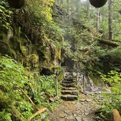
You can see a lot of pretty sights within a very short distance and it's a relatively easy hike. Go off the beaten path to find more beautiful nature scenes! You won't be disappointed in the waterfalls, rushing rivers, immaculate trees and serene spaces. A great little hike for the family. Parking is located right at the trailhead and bathrooms are available.
")
1 year ago
We have passed by this amazing place so many times, and finally stopped to check it out. It is a very easy hike through the area, suitable for all ages. The scenery is breathtaking! Highly recommend. read more


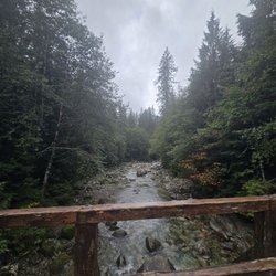
Deception Falls was our first hike on the Western side of the Cascade Mountains. It was barely over the ridge, but it was easy to see the contrast between the Eastern and Western sides. The Eastern side was noticeably drier, although not dry by normal standards. I would call it normal rather than dry. The Western side had moss on the trees, lichen hanging from the branches and ferns covering the forest floor. Deception Falls was the perfect place to experience it. Even the trail was soft to the touch, decades of rotting wood replenishing the soil under foot. It was a striking experience to walk on the Deception Falls trail. My wife and I both had the feeling that we were walking in a fantasy land. The trees were a new variety and covered in moss, the waters were crystal clear, and the sunlight shown through it all to accentuate the colors. I think we saw the area at the perfect time of year. If it was overcast, cold, or rainy, we would not have had the same experience. Also, the river seemed to be at full strength, forcefully pounding and shaping the rock at each section of the falls. Looking at other pictures of the river from October, the river levels fluctuate dramatically. Our falls experience would've been different if the river was a trickle rather than a torrent. I didn't see any fish in the river when we were there. A nearby sign indicated that the cold, ultra clean waters did not provide favorable conditions or sufficient food for anything other than small fish. I don't know too much about fish in northwest at this time, but it would surprise me if fish could swim up this river. If there were any fish at Deception Falls, they were stuck between the rapids, living in a calendar year that changes from high water to low water. That doesn't seem like ideal conditions for large fish. There was a bridge near the end of the trail that spanned the most forceful section of the rapids. It was a fitting climax, a moment of triumph and emotion, at the end of the trail. Standing in the center of the bridge is adrenaline inducing. Spray from the rapids hits you along with the thunderous noise of water crashing against rock. You know that the bridge will hold you yet there is a lingering thought in the back of your mind praying for the bridge to stay strong. Continuing forward, a short walk under the bridge provides more views of the water crashing down from above and more opportunities to stand in the mist. read more


4 years ago
Biggest deception about Deception Falls is the map location in yelp. If you find yourself at a bridge into town, you're at the wrong location. It is actually 8 miles further up the hill than what the map shows. Technically it's closed but you can park on the road side. There's plenty of safe parking space. Short walk to get down to the falls. Very beautiful and worth the stop. read more


3 years ago
Absolutely gorgeous stop. Be sure to stop here. Very easy to get to the falls right from the parking lot. read more


Definitely must stop by if your on your way up here! The address on here sends you somewhere else, so I would suggest looking it up on the trails website. Drive up highway 2, pass mile 56 east then on the left there should be a sign deception falls with plenty of parking & nasty potty's! I highly recommend walking down the bottom of the trail and then working your way up! We walked off the trail on the left side and found a beautiful area which you could probably take a quick swim in. Everything about the falls is so breathtaking & worth the photos! read more


7 years ago
Short scenic walk to the waterfall viewpoint for those who want to have the views without the strenuous hike. There are also hikes there, i want to check out but definitely next time! Very close to our cabin in Skykomish read more


My family refers to this hike as the "Mushroom hike". It's a short loop, take it slow and look around, so much to be explored. Great views and spots to pull off and just let the kids adventure around for a little. We love this hike all times of the year, great spot to stop and stretch your legs when in the area. **Highly recommend for families with small children.** read more


8 years ago
3 years ago
7 years ago
Sooooo beautiful awesome! And I want to go back again!!!! Everyday! The water was so pure and clear and the trails were amazing and so much fun! So many great photography Opportunities if your into that! Also beautiful hike read more


9 years ago
9 years ago
8 years ago
You can see a lot of pretty sights within a very short distance and it's a relatively easy hike. Go off the beaten path to find more beautiful nature scenes! You won't be disappointed in the waterfalls, rushing rivers, immaculate trees and serene spaces. A great little hike for the family. Parking is located right at the trailhead and bathrooms are available. read more


9 years ago
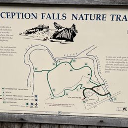
Myself and out of town family stopped on our way to Leavenworth. We experienced rain, sleet, mist and sunbreaks all in the same hour. The lower section of the loop trail had huge trees obstructing the trail--totally possible to climb over with caution. During this time of the year, I wouldn't recommend pets or children until clean-up has taken place. Otherwise, I was impressed with the condition of the trail with multiple bridges, waterfalls and interpretation signs. I will definitely be back! --Full review in progress-- read more
 - Hiking Near Me - Skykomish, Washington")


 - Hiking Near Me - Skykomish, Washington")


8 years ago
5 years ago
7 years ago
More info about Deception Falls
Stevens Pass Hwy
Skykomish, WA 98288
Directions
Hours
Outdoor Amenities
Ask the Community - Deception Falls
Review Highlights - Deception Falls


Why does Yelp recommend reviews?
1 review that is not currently recommended
The reviews below are not factored into the business's overall star rating.
10 years ago
Deception Falls - hiking - Updated June 2026
Best of Skykomish
People found Deception Falls by searching for…
Hiking Trails With Waterfalls in Skykomish, Washington
Lakes in Skykomish, Washington
Things to Do in Skykomish, Washington
Parks in Skykomish, Washington
Fishing in Skykomish, Washington
Scenic Drive in Skykomish, Washington
Scenic View in Skykomish, Washington
Easy Hikes in Skykomish, Washington
Waterfalls and Swimming Holes in Skykomish, Washington
Lookout Points in Skykomish, Washington
Photo Spots in Skykomish, Washington
View Points in Skykomish, Washington
River Swimming in Skykomish, Washington
Beautiful Views in Skykomish, Washington
Hiking With Kids in Skykomish, Washington
Scenic Spots in Skykomish, Washington
Scenic Overlook in Skykomish, Washington
Walking Trails in Skykomish, Washington
Swimming Lakes in Skykomish, Washington
Parks for Kids in Skykomish, Washington
Off Road Trails in Skykomish, Washington
Fishing Lake in Skykomish, Washington
Trending Searches in Skykomish, WA
Browse Articles
Browse Nearby
BEST of Skykomish, Washington Things to Do near Deception Falls
BEST of Skykomish, Washington Coffee near Deception Falls
BEST of Skykomish, Washington Scenic View near Deception Falls
BEST of Skykomish, Washington Restaurants near Deception Falls
BEST of Skykomish, Washington Parks near Deception Falls
BEST of Skykomish, Washington Hot Springs near Deception Falls
BEST of Skykomish, Washington Campgrounds near Deception Falls
BEST of Skykomish, Washington Sledding near Deception Falls
BEST of Skykomish, Washington Breakfast near Deception Falls
Browse Brands
Related Searches in Skykomish, WA
Best Fishing Locations and Guides in Skykomish, Washington
Best Nature Trails for Hiking in Skykomish, Washington
Best Places for Horseback Riding in Skykomish, Washington
Best Sledding Spots and Fun in Skykomish, Washington
Best Spots for Star Gazing in Skykomish, Washington
Best Waterfalls and Swimming Holes in Skykomish, Washington
Check Out Off Road Trails in Skykomish, Washington
Discover Dog Friendly Trails to Explore in Skykomish, Washington
Discover Popular Bike Trails in Skykomish, Washington
Discover Popular Photo Spots in Skykomish, Washington
Discover Scenic Mountain Bike Trails Near Skykomish, Washington
Discover Top Nature Parks to Visit in Skykomish, Washington
Discover a Hiking Trail in Skykomish, Washington
Dog-Friendly Hikes With Dogs in Skykomish, Washington
Enjoy Camping Adventures Around Skykomish, Washington
Enjoy Exciting Mountain Biking Adventures in Skykomish, Washington
Enjoy Scenic Night View Experiences in Skykomish, Washington
Enjoy the Best Night View Spots in Skykomish, Washington
Enjoy the Best Tubing Experiences in Skykomish, Washington
Enjoy the Best Walking Trails in Skykomish, Washington
Exciting Cliff Jumping Spots in Skykomish, Washington
Explore Beautiful Parks and Green Spaces in Skykomish, Washington
Explore Bike Rentals Throughout Skykomish, Washington
Explore Easy Hikes Perfect for All in Skykomish, Washington
Explore Popular Campgrounds Near Skykomish, Washington
Explore Popular RV Parks Around Skykomish, Washington
Explore Popular Scenic Overlook Points in Skykomish, Washington
Explore Popular View Points Around Skykomish, Washington
Explore Scenic Lakes to Visit in Skykomish, Washington
Explore the Best Swimming Holes Around Skykomish, Washington
Explore the Best Trail Options in Skykomish, Washington
Family Friendly Hiking With Kids in Skykomish, Washington
Find Beautiful Views in Skykomish, Washington
Find Fun Kids Activities Outdoor in Skykomish, Washington
Find Parks and Recreation Activities in Skykomish, Washington
Find Popular Ziplining Spots Around Skykomish, Washington
Find the Best Scenic View Locations in Skykomish, Washington
Hiking Trails With Waterfalls in Skykomish, Washington
Off Leash Dog Hiking Trails in Skykomish, Washington
Picnic Areas With BBQ Pits Available in Skykomish, Washington
Plan a Scenic Drive Route Near Skykomish, Washington
Popular Kids Activities in Skykomish, Washington
Popular Things to Do in Skykomish, Washington
Popular Things to See in Skykomish, Washington
Safe River Swimming Areas in Skykomish, Washington
Top Climbing Spots and Gyms in Skykomish, Washington
Top Paddleboarding Activities in Skykomish, Washington
Top Running Trails to Explore in Skykomish, Washington
People who viewed Deception Falls also viewed
Wallace Falls State Park
199 reviews
Lake Serene Peak
6 reviews
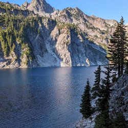
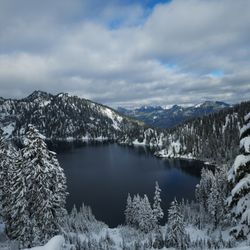
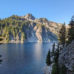
Blanca Lake
38 reviews
Barclay Lake
6 reviews
Tolt-MacDonald Park & Campground
36 reviews
Lake Bronson Club Family Nudist Park
11 reviews
Rattlesnake Ledge Trail
214 reviews
Heybrook County Park Trailhead
7 reviews
Rattlesnake Ridge
170 reviews
Cedar Butte Trail
4 reviews