Heybrook County Park Trailhead Photos


More like Heybrook County Park Trailhead
Recommended Reviews - Heybrook County Park Trailhead
Start your review...

Reviews With Photos

Came here on a weekday afternoon around 5PM, a few cars parked but didn't see too many people. Hike wasn't very steep, got up in about 50 mins, there's 7 flights of 12 stairs each to get up to the lookout. Was a bit cloudy so didn't see much, but still a good view. Went a bit further to Heybrook Mountain but really nothing to see there, just power lines. Quick trail for a weekday afternoon!

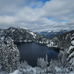
This trail is pretty nice. I went about a week ago and it was still kinda slippery from the snow. It's fairly easy going up if you are in shape and going down is great as well as long as it's not to snowy. I would definitely recommend going here but maybe not in the wintertime or at least not when it is so snowy.

Pretty steep for a quick two mile hike but definitely worth it!! It was pretty muddy when I went so I recommend bringing a nice pair of hiking shoes and trekking poles. I love that this hike doesn't require any pass or fee. There's no restroom, so Espresso Chalet is a good place to stop to use the restroom before the hike! The trail was pretty quiet, we only saw a few people on the way up and down. We had the top of the lookout to ourselves for about 15mins, before groups of people started to arrived so if you want privacy go early. Either way it wasn't too crowded and people were considerate with taking turns at the front of the lookout. read more


3 years ago
Nothing special. Lot of stones and rooted under the feet. Pretty steep elevation under the trees. View from the top is just ok. Trees hide half of the mountains view even if you climbed to the lookout read more
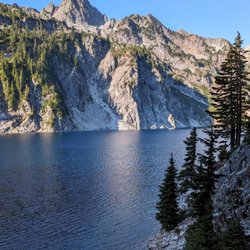
Another hiking review? Groundbreaking. Heybrook Lookout is a short and sweet hike that I recommend ANYBODY try if they're just getting into hiking or just haven't done it before! It's located out in the Gold Bar/Index area, not too far from the Wallace Falls and Lake Serene trailheads. In fact, you can even see Bridal Veil Falls off in the distance once you reach the top of Heybrook Lookout. Note that the parking lot might catch you off guard, as it's kind of off the side of the road with no big markers at first. You'll see the trailhead sign up into the trail a little bit, but it's not marked in the "parking lot" which is just big enough for about 10-15 cars. We got there and there was plenty of space to park - when we were leaving at about 10 am, it was PACKED with people pulled off on the road waiting for early hikers to leave. For beginners, this hike might be a challenge. Doable, but a challenge. It's 2.6 miles roundtrip, and in that, you get 850 ft of elevation gain. It's not incredibly steep, but it's pretty consistent the entire way up with very little flat parts. Making it to the top took us an hour ish, maybe less. The views open up and you pretty much know you're there as you can see the lookout right at the top. The lookout has a goooood amount of stairs - prepare for leg day, basically. You're not able to go to the VERY top floor of the lookout because it's a space that people are able to rent to stay overnight in! There was a family up there the day we went, and they came down to talk to hikers and were super nice. Apparently it costs $75 a night to rent the lookout top floor which is something I feel like everyone has to do once in their lifetime. The sunrise here, I'm sure, is gorgeous. There is a toilet at the top next to the lookout as well. I didn't go, but the option is there. All in all, highly recommend for a great way to start your day. It's about 2 hours total and who doesn't like to start their day with great views and a nice workout? read more


Came here on a weekday afternoon around 5PM, a few cars parked but didn't see too many people. Hike wasn't very steep, got up in about 50 mins, there's 7 flights of 12 stairs each to get up to the lookout. Was a bit cloudy so didn't see much, but still a good view. Went a bit further to Heybrook Mountain but really nothing to see there, just power lines. Quick trail for a weekday afternoon! read more


4 years ago
This trail is pretty nice. I went about a week ago and it was still kinda slippery from the snow. It's fairly easy going up if you are in shape and going down is great as well as long as it's not to snowy. I would definitely recommend going here but maybe not in the wintertime or at least not when it is so snowy. read more


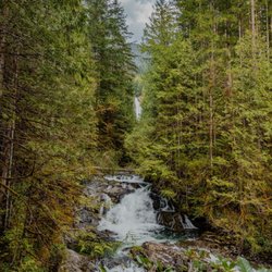
Great little place to go for a two hour hike! .-. I literally had to make the business cuz I couldn't find anywhere here. O.O so feel free to edit anything in this business. Let's hike our way through blazing trail and find out what makes it so amazing! Atmosphere/community: Welp, you start from the bottom and end at the top the end. Moving on! Lol. Jk o.o it has a small parking lot and the trail is well paced. The vegetation compliment so much of the scenery and it's a great spot in any section of the trail to stop and capture the moment of nature at its finest moment. (That and because there's no service up there, soooo enjoy it. Lol) it looks well maintain and the path is clear. With a gradual but not hard inclines in moments of the climb, I'd say it's a great trail for beginners! O.O plus it's freeeeeeee, I mean it doesn't get better than that! *heavy breathing* The people in the trail we're very respectful and even in a pandemic wore mask and greeted us with smiles. (I loved the positive vibe that had install here. [plus you didn't get weird people that bought expensive clothes and were there just to impress others with how much their hiking boots were.]) Just people that were there to improve their health and pass the time with a fun physical activity! *smiley face* Conclusion: If you ever get lost or forget your Northwest Forest pass at home and already drove an hour and half to just turn around... DONT! Give this place a try! At least get something that's free, with great friendly faces and still a good experience of a hike. :3 read more


4 years ago
More info about Heybrook County Park Trailhead
50606 Index-Galena Rd
Index, WA 98294
Directions
Hours
Outdoor Amenities
Ask the Community - Heybrook County Park Trailhead


Heybrook County Park Trailhead - hiking - Updated June 2026
Best of Index
People found Heybrook County Park Trailhead by searching for…
Things to Do in Index, Washington
Hiking Trails in Index, Washington
Easy Hikes in Index, Washington
Stairs Workout in Index, Washington
Sunrise View in Index, Washington
View Points in Index, Washington
Sunrise Hike in Index, Washington
Off Road Trails in Index, Washington
Night View in Index, Washington
Scenic Overlook in Index, Washington
Natural Hot Springs in Index, Washington
Stair Climbing in Index, Washington
Walking Trails in Index, Washington
Night Hike in Index, Washington
Lookout Points in Index, Washington
Waterfall Hike in Index, Washington
Secluded Spots in Index, Washington
Kid Friendly Hiking Trails in Index, Washington
Places to Take Pictures in Index, Washington
Trending Searches in Index, WA
Boat Rental near Heybrook County Park Trailhead
Cliff Jumping near Heybrook County Park Trailhead
Fishing Spots near Heybrook County Park Trailhead
Kayak Rental near Heybrook County Park Trailhead
Lakes near Heybrook County Park Trailhead
Parks near Heybrook County Park Trailhead
Browse Articles
Browse Nearby
Browse Brands
Related Searches in Index, WA
Affordable Kayak Rental Services in Index, Washington
Best Fishing Locations and Guides in Index, Washington
Best Fun Things to Do in Index, Washington
Best Nature Trails for Hiking in Index, Washington
Best Places for Horseback Riding in Index, Washington
Best Sledding Spots and Fun in Index, Washington
Best Spots for Star Gazing in Index, Washington
Best Waterfalls and Swimming Holes in Index, Washington
Check Out Off Road Trails in Index, Washington
Discover Dog Friendly Trails to Explore in Index, Washington
Discover Popular Bike Trails in Index, Washington
Discover Popular Photo Spots in Index, Washington
Discover Scenic Mountain Bike Trails Near Index, Washington
Discover Top Boat Tours in Index, Washington for All Ages
Discover Top Nature Parks to Visit in Index, Washington
Discover a Hiking Trail in Index, Washington
Discover the Best Night Hike Trails in Index, Washington
Dog-Friendly Hikes With Dogs in Index, Washington
Effective Stairs Workout Spots in Index, Washington
Enjoy Camping Adventures Around Index, Washington
Enjoy Tent Camping Spots Around Index, Washington
Enjoy the Best Tubing Experiences in Index, Washington
Enjoy the Best Walking Trails in Index, Washington
Exciting Cliff Jumping Spots in Index, Washington
Explore Beautiful Parks and Green Spaces in Index, Washington
Explore Easy Hikes Perfect for All in Index, Washington
Explore Popular Campgrounds Near Index, Washington
Explore Popular Scenic Overlook Points in Index, Washington
Explore Popular View Points Around Index, Washington
Explore Scenic Lakes to Visit in Index, Washington
Explore the Best Boating Spots in Index, Washington
Explore the Best Swimming Holes Around Index, Washington
Explore the Best Trail Options in Index, Washington
Family Friendly Hiking With Kids in Index, Washington
Find Beautiful Views in Index, Washington
Find Parks and Recreation Activities in Index, Washington
Find the Best Playgrounds to Visit in Index, Washington
Find the Best Scenic View Locations in Index, Washington
Hiking Trails With Waterfalls in Index, Washington
Off Leash Dog Hiking Trails in Index, Washington
Perfect Spots to Watch Sunset in Index, Washington
Plan a Scenic Drive Route Near Index, Washington
Popular Fishing Spots to Explore in Index, Washington
Popular Kids Activities in Index, Washington
Popular Places to Take Pictures in Index, Washington
Popular Things to Do in Index, Washington
Relax at Natural Hot Springs Near Index, Washington
Top Paddleboarding Activities in Index, Washington