
Alpine Lakes Wilderness Photos


You might also consider
More like Alpine Lakes Wilderness
Recommended Reviews - Alpine Lakes Wilderness
Start your review...

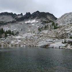
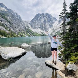
Alpine Lakes Wilderness is a huge area including the Enchantment and Big Heart Lake-Necklace Valley loop. These two are the one I backpacked in this wilderness, and super beautiful. However, there are literally tons of other hiking available here. For detail My blog for the Enchantment https://himebackpacker.blogspot.com/2024/10/the-enchantments-washington.html My blog for the Big Heart Lake-Necklace Valley loop https://himebackpacker.blogspot.com/2024/11/big-heart-lake-necklace-vally-loop.html read more


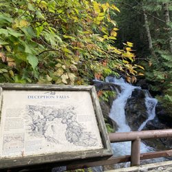
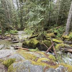
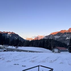
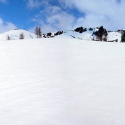
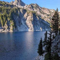
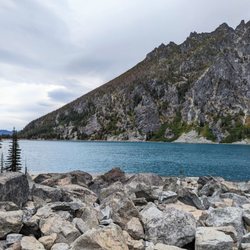
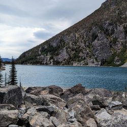
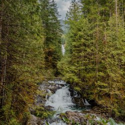
Alpine Lakes is a large wilderness area west of Leavenworth full of multiday long trails. While I didn't take any multiday hikes or reach any of the alpine lakes, I was able to explore the area with afternoon or post work hikes. Before arriving in Leavenworth, I was originally intending to fish some of the lakes in the wilderness. However, this would have require more planning and effort that I was able to exert during my time in the area. I bet the lakes are pristine. Maybe I will be able to fish in them on a future date. The quality trails in the area generally lead hikers through the valleys, creeping up the mountains. There are great views of the snow-capped peaks from most parts of the trail and when there isn't one in view, there are usually rapids rushing down a nearby creek or river. In this part of the country, there are no small creeks. If there is a blue line on google maps, you can count on loud whitewater, rather than small trickle in June. Part of the wilderness shows signs of fire damage that occurred 4 years ago, although there is significant regrowth of small pine trees and bushes retaking the mountainside. This is a dramatic contrast from the burned landscapes that we saw in Arizona, California, or Nevada, where a fire from previous years would show little signs of regrowth, almost as if the fire was the earth's first step on its march toward becoming a desert. read more


More info about Alpine Lakes Wilderness
Skykomish, WA 98288
Directions
Hours
Outdoor Amenities


Alpine Lakes Wilderness - parks - Updated July 2026
Best of Skykomish
People found Alpine Lakes Wilderness by searching for…
Trending Searches in Skykomish, WA
Lakes near Alpine Lakes Wilderness
Lookout Points near Alpine Lakes Wilderness
Playgrounds near Alpine Lakes Wilderness
River Swimming near Alpine Lakes Wilderness
Swimming Holes near Alpine Lakes Wilderness
Swimming Lakes near Alpine Lakes Wilderness
Things To Do On A Rainy Day near Alpine Lakes Wilderness
Browse Articles
Browse Nearby
BEST of Skykomish, Washington Things to Do near Alpine Lakes Wilderness
BEST of Skykomish, Washington Hiking near Alpine Lakes Wilderness
BEST of Skykomish, Washington Scenic View near Alpine Lakes Wilderness
BEST of Skykomish, Washington Restaurants near Alpine Lakes Wilderness
BEST of Skykomish, Washington Coffee near Alpine Lakes Wilderness
BEST of Skykomish, Washington Campgrounds near Alpine Lakes Wilderness
BEST of Skykomish, Washington Breakfast near Alpine Lakes Wilderness
BEST of Skykomish, Washington Snow Tubing near Alpine Lakes Wilderness
BEST of Skykomish, Washington Lodging near Alpine Lakes Wilderness
Browse Brands
Related Searches in Skykomish, WA
Best Fishing Locations and Guides in Skykomish, Washington
Best Parks for Parties and Events in Skykomish, Washington
Best Places for Horseback Riding in Skykomish, Washington
Best Water Parks for Kids in Skykomish, Washington
Discover Baseball Fields Around Skykomish, Washington
Discover Fun Toddler Parks in Skykomish, Washington for Your Little One
Discover Popular Bike Trails in Skykomish, Washington
Discover Popular Photo Spots in Skykomish, Washington
Discover Top Nature Parks to Visit in Skykomish, Washington
Discover the Best Beaches in Skykomish, Washington
Enjoy Hiking Adventures in Skykomish, Washington
Enjoy the Best Picnic Spots and Ideas in Skykomish, Washington
Enjoy the Best Tubing Experiences in Skykomish, Washington
Enjoy the Best Walking Trails in Skykomish, Washington
Experience Stunning Sunset Views in Skykomish, Washington
Explore Easy Hikes Perfect for All in Skykomish, Washington
Explore Free Picnic Areas Around Skykomish, Washington
Explore Landmarks & Historical Buildings in Skykomish, Washington
Explore Parks With Pull Up Bars in Skykomish, Washington
Explore Picnic Parks Near Skykomish, Washington
Explore Popular Campgrounds Near Skykomish, Washington
Explore Popular Picnic Areas Around Skykomish, Washington
Explore Popular RV Parks Around Skykomish, Washington
Explore Popular Scenic Views Near Skykomish, Washington
Explore Popular View Points Around Skykomish, Washington
Explore Scenic Lakes to Visit in Skykomish, Washington
Explore Top Dog Parks in Skykomish, Washington Near You
Explore Top Gyms in Skykomish, Washington Now
Family Friendly Hiking With Kids in Skykomish, Washington
Find Beautiful Views in Skykomish, Washington
Find Great Places to Feed Ducks in Skykomish, Washington
Find Parks and Recreation Activities in Skykomish, Washington
Find the Best Parks BBQ Grills in Skykomish, Washington
Find the Best Playgrounds to Visit in Skykomish, Washington
Find the Best Swimming Pools in Skykomish, Washington Today
Have Fun at a Splash Pad in Skykomish, Washington
Hiking Trails With Waterfalls in Skykomish, Washington
Must-See Tourist Attractions Around Skykomish, Washington
Picnic Areas With BBQ Pits Available in Skykomish, Washington
Plan a Scenic Drive Route Near Skykomish, Washington
Popular Kids Activities in Skykomish, Washington
Popular Picnic Spots to Visit in Skykomish, Washington
Popular Things to Do in Skykomish, Washington
Safe and Fun Parks for Kids in Skykomish, Washington
Top Running Trails to Explore in Skykomish, Washington
Top-Rated Camping Sites in Skykomish, Washington


