Minotaur Lake Photos


You might also consider
More like Minotaur Lake
Recommended Reviews - Minotaur Lake
Start your review...

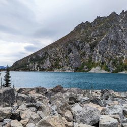
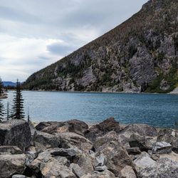
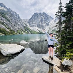
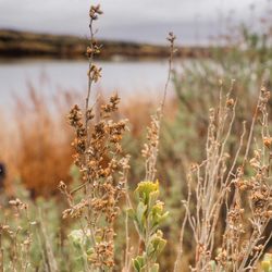
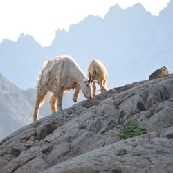
A short 1.75 mile trail gets you to two beautiful alpine lakes. A little longer and you can reach the summit of Labyrinth Mountain (an official summit with a register). The main downside is that most of that 1.75 miles is super steep and unforgiving. I think technically it's not even a real trail, it's a "route" -- basically just a path to get you up as quickly as possible. But you'll forget all of your suffering as soon as you reach the lakes. You'll see the shores of Minotaur with Labyrinth Mountain in the background, and there are trails going around both sides of the lake, with plenty of nice campsites available. If you go around the right side of the lake, the network of trails will lead to many viewpoints down to Theseus Lake. You can get down to Theseus, too, but it's a steep fisherman's trail that descends several hundred feet, so not recommended unless you really want solitude. The social network of trails to Labyrinth can make the summit trip a little longer depending on what path you choose, but the openness of the terrain ensures that you won't get lost. There's a false summit or two. Facing Labyrinth from Minotaur Lake, the true summit is on the right. There's a summit register you can sign and glorious views, including Lake Wenatchee and Glacier Peak. I went in the summer, but it would be gorgeous in the fall with the brilliant colors, and I saw a lot of huckleberry plants. read more

7 years ago
More info about Minotaur Lake
Chelan, WA 98826
Directions
Visit Website
http://www.wta.org
Hours
Outdoor Amenities


Minotaur Lake - hiking - Updated July 2026
Best of Chelan
People found Minotaur Lake by searching for…
Trending Searches in Chelan, WA
Cliff Jumping near Minotaur Lake
Dog Friendly Trails near Minotaur Lake
Jet Ski Rental near Minotaur Lake
Kayak Rental near Minotaur Lake
Off Road Trails near Minotaur Lake
Paddle Board Rental near Minotaur Lake
Swimming Lakes near Minotaur Lake
Things To Do On A Rainy Day near Minotaur Lake
Browse Articles
Browse Brands
Related Searches in Chelan, WA
Affordable Canoe Rental Options in Chelan, Washington
Affordable Kayak Rental Services in Chelan, Washington
Affordable Paddle Board Rental in Chelan, Washington
Best Dog Hiking Trails Around Chelan, Washington
Best Fishing Locations and Guides in Chelan, Washington
Best Fun Things to Do in Chelan, Washington
Best Places for Horseback Riding in Chelan, Washington
Best Sledding Spots and Fun in Chelan, Washington
Best Water Parks for Kids in Chelan, Washington
Check Out Off Road Trails in Chelan, Washington
Discover Dog Friendly Trails to Explore in Chelan, Washington
Discover Top Boat Tours in Chelan, Washington for All Ages
Discover a Hiking Trail in Chelan, Washington
Discover the Best Beaches in Chelan, Washington
Discover the Best Night Hike Trails in Chelan, Washington
Dog-Friendly Hikes With Dogs in Chelan, Washington
Enjoy Camping Adventures Around Chelan, Washington
Enjoy Kayaking Adventures in Chelan, Washington
Enjoy Off Leash Dog Hikes in Chelan, Washington
Enjoy Tent Camping Spots Around Chelan, Washington
Enjoy the Best Walking Trails in Chelan, Washington
Explore Beautiful Parks and Green Spaces in Chelan, Washington
Explore Bike Rentals Throughout Chelan, Washington
Explore Easy Hikes Perfect for All in Chelan, Washington
Explore Fun Activities to Do in Chelan, Washington
Explore Popular Campgrounds Near Chelan, Washington
Explore Popular RV Parks Around Chelan, Washington
Explore Scenic Lakes to Visit in Chelan, Washington
Explore the Best Beach Spots in Chelan, Washington
Explore the Best Swimming Holes Around Chelan, Washington
Family Friendly Hiking With Kids in Chelan, Washington
Find the Best Playgrounds to Visit in Chelan, Washington
Off Leash Dog Hiking Trails in Chelan, Washington
Perfect Spots to Watch Sunset in Chelan, Washington
Popular Things to Do in Chelan, Washington
Relax at Natural Hot Springs Near Chelan, Washington
Safe and Fun Parks for Kids in Chelan, Washington
Top Hiking Trails to Explore in Chelan, Washington
Top Paddleboarding Activities in Chelan, Washington
Top Playgrounds for Kids to Enjoy in Chelan, Washington
Top Running Trails to Explore in Chelan, Washington
Top Swimming Spots and Pools in Chelan, Washington
Top Things to Do With Kids in Chelan, Washington
Top-Rated Boat Rental Services in Chelan, Washington
Top-Rated Camping Sites in Chelan, Washington