Mummy Mountain Photos


You might also consider
More like Mummy Mountain
Recommended Reviews - Mummy Mountain
Start your review...

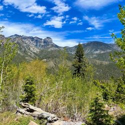
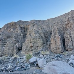
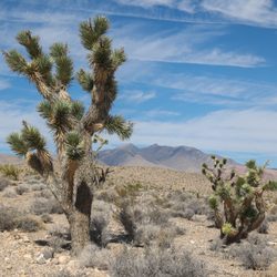
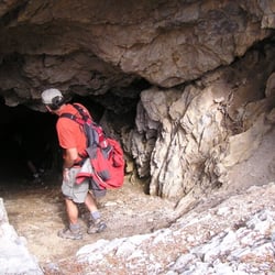
Mummy Mountain is the second highest peak in the Charleston area. It gets its name from its resemblance to a mummy, from different view points, especially from US 95, it looks like a mummy lying down. There are several ways to get to mummy, and there are several different points of interest. Mummy's knee, toe, chin, belly. The route I took for Mummy Mountain, aka Mummy's Tummy or Belly is starting at Trail Canyon. Starting out at the Trail Canyon Trailhead, you hike up two miles, and 1500 feet of elevation gain. Once you get to the saddle, you will follow the North Loop Trail, you will pass Cave Springs, which is a horse trough that has water piped into it, usually year round, and then you will start hitting the switchbacks, this is probably one of my favorite areas because of the quacking aspen trees. You will then come across a large tree that has the letter "B" carved into it, for Burntree. This is your way point to turn off, you will see the scree slope that you will be climbing up. From here, you will have 600 feet of scree to scramble up, hiking poles were really helpful here. You will definitely be feeling the burn going up this. Once you reach the top, look for the cairns that will lead you to a semi trail. You will hit yet another scree shoot, this one required some scrambling as well. I enjoyed this section the most. Once you hit the summit, you will feel like you had an awesome cardio and circuit workout. The views were great. This is a strenuous hike. Between the elevation gain and the scree shoots, you most certainly need to come prepared. Quick stats: Trailhead: Trail Canyon Distance: 8.5 miles - up and back Elevation gain: 3,732 feet Elevation of peak: 11,542 feet Bring lots of water, hiking poles and rain gear if coming during monsoon season. read more


 - Hiking Near Me - Mt Charleston, Nevada")


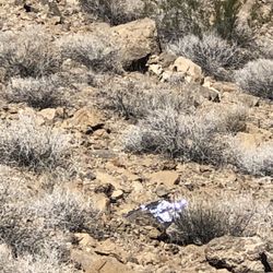
WELL this one was hard my legs and lungs did not want to do what I wanted them to do, this not for beginners unless you are very fit. Man, I thought I came close to god during times of skeptical breathing, but powered through and got thru. This is a pretty tough hike it is steep and rocky and you will loose your footing in the beginning of the trail, it then leads to a heavily forested the incline felt incredibly steep switchback trail into a rocky switchback trail. It is a strenuous to difficult trail be prepared and trained and have water. There are especially steep slopes near and past the main summit. When you see everyone leaving for back home you should go on. If you do decide to it gets better then it gets worse or better depends on the point of view. For me with my fear of heights both... The views past the point of main travelers is amazing peaceful views of gullys, ravines, valleys, cliffs, so worth it You will gain about 1900' and 7 mile if you go to raintree 8.5 round trip to raintree, this is the second highest peak in the NV area but you are not going to the top. There are a couple of spots that are extremely narrow and very difficult but not enough to just skip it. There were a few points I was done, but I kept on the views were amazing. The switchbacks are killer but when you get to the summit, WOW. The views become amazing as if they were not already. It becomes somewhat flat and soon you will run into raintree if you planed for it you can the go down the other side (my last review) or go back down. So here is my gripe for this one. On our end decent close to the bottom you cant help but notice a rescue chopper circling us. We were wondering "well we haven't been gone the long" kept going down and the chopper kept circling us?! Finally we see why, a group of amazing rescue workers are headed up the trail. These men were trudging up the hill to rescue a man and his horse who got off trail and fell down. These men had a VERY LONG WAY TO GO. To save some guy who, well I wont get into my personal thoughts. All I am saying is your safe Hike it, have fun train, be prepared and enjoy the amazing views! read more


More info about Mummy Mountain


Mummy Mountain - hiking - Updated July 2026
Best of Mt Charleston
People found Mummy Mountain by searching for…
Lakes in Mt Charleston, Nevada
Hiking Trails With Waterfalls in Mt Charleston, Nevada
Things to Do in Mt Charleston, Nevada
Places to Take Pictures in Mt Charleston, Nevada
Scenic View in Mt Charleston, Nevada
Easy Hikes in Mt Charleston, Nevada
Picnic Areas in Mt Charleston, Nevada
Playgrounds in Mt Charleston, Nevada
Canyoneering in Mt Charleston, Nevada
Hiking Groups in Mt Charleston, Nevada
Swimming Lakes in Mt Charleston, Nevada
Secret Spots in Mt Charleston, Nevada
Fun Things to Do at Night in Mt Charleston, Nevada
Running Trails in Mt Charleston, Nevada
Tent Camping in Mt Charleston, Nevada
Lakes & Ponds in Mt Charleston, Nevada
River Swimming in Mt Charleston, Nevada
Bonfire in Mt Charleston, Nevada
Scenic Overlook in Mt Charleston, Nevada
Night Hike in Mt Charleston, Nevada
Walking Trails in Mt Charleston, Nevada
Attractions in Mt Charleston, Nevada