Bristlecone Trail Photos


You might also consider
More like Bristlecone Trail
Recommended Reviews - Bristlecone Trail
Start your review...

Reviews With Photos

As a big nature person and the mountains been the closest thing to green here in the lovely nevada , I can say I love this place beyond anything else . Many people that visit hardly know there's a green area to Nevada and maybe it's better or maybe not ? I love how tranquil and green and fresh it is up here but also wish to share this beautiful piece of heaven in the desert . All the mountain trails of mount Charleston are a must try ! I'm surprised I never did a review on this place but maybe I was too busy enjoying it The place is amazing to do a big hike , just a stroll on the lower canyon , perhaps a picnic with a beautiful view of wild horses and if your lucky enough , you get to see deer . This rainy season has surprised me so much compared to the past years . I recently started doing some mycology study and research and I decided to venture on the highest elevation and explore around , well .... here it's my biggest treasure find . Note : please never ingest anything you find on forest nor on floor , all this treasure was for research and for the love of nature and mycology . Foraging mushrooms do not interfere with mountain ecosystem , on the contrary , it helps the spores spread around , more life ! Many species are un edible to wild life and humans ( again ! Do not eat if you ain't sure of the ID ) . Besides finding and foraging we love hiking here all the time . My biggest recommendation is to please take your trash with you ! Take care of this place ! Have fun and enjoy it !

Beautiful trail to hike! It wasn't as steep as Cathedral Rock, kids enjoyed it as well. Trees just started to turn colors and just all in all a beautiful scenery. I wish they had more information on the trail like how far it was, yes it was our fault not to check it out but we were there mainly to check out the ski lift and the resto but decided to check out the hike also. We'll go back and we'll be ready next time! Ps Dog & whole family friendly!

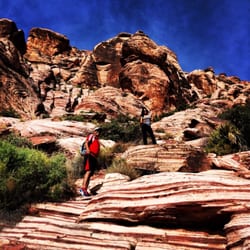
Amazing, well marked trail with stunning views and some great elevation changes. The whole loop if you hike the lower an upper bristlecone is 5.7 miles. The trail is mountain bike and dog friendly so be sure to pay attention. We came super early in the morning so it wasn't very crowded. If you park at the upper bristlecone trailhead then you will have climbing to do at both the beginning and the end of the hike. If you prefer not to climb at the end of your hike, park down by the campgrounds or the lower bristlecone trailhead. We were able to see some of the local flora and fauna to include some wild horses on the trail. It was quite an experience! I will definitely be back when the aspens start to change in the Fall.

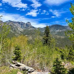
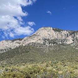
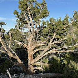
I have hiked Bristlecone Trail many times over the years. It's one of our hikes in the hot summer months when we escape the heat of the Las Vegas Valley and head to Mount Charleston to enjoy temperatures that are about 20 degrees cooler. The only thing about the hike that gets to you sometimes is the elevation. The hike starts at about 8,700 feet and reaches its high point at 9,400 feet. Along the way, you have some great views of the ski center, the aspen grove near the ski area, some bristlecone pines, and white pine. The first part of the hike is uphill. I normally do this hike by parking in the Lower Trailhead area and hike up the road to the Upper Trailhead. When I'm done, I'm back where I left the car. The second half of the hike is on an old Civilian Conservation Corps (CCC) road that was being built in the 1930s and 1940s. It was stopped as World War II started because the men were needed for soldiers, not road builders. At different times of the summer season, you can enjoy the trail in different ways. The aspen in the fall are quite nice. Early in the summer season, there will still be snow on Mount Lee above the ski area. The trail is also used by mountain bikers, especially on weekends, so you need to be on the lookout for them.

Bristlecone Trail (Mount Charleston, NV) Bristlecone Trail is one of my favorite hikes in Mount Charleston that do not involve a steep climb. I'm not stating that there's no incline. Bristlecone Trail is easier than Trail Canyon, Mary Jane Falls, and Cat Rock. Bristlecone Trail can be started from either the Lower or Upper Trailhead. Starting at the Upper Trailhead is easier since there's less hills to climb and the hike starts off in shade. The trail is marked well and easy to follow. There's not much of a peak. I bet that the views during January through March are amazing. Be on the lookout for wild horses. They frequent the area and we found the spot where they like to hang out. ADDITIONAL INFO & TIPS *Located in Mount Charleston *Directions from Las Vegas: 95 North, exit Lee Canyon, and just follow the road towards McWilliams (Lower Trailhead) *Parking at the Lower Trailhead or Upper Trailhead *Be prepared with enough hydration, good pair of shoes, and layers. Keep in mind it's about 20 degrees cooler than Vegas *Loop is about 7 miles *Pay attention for mountain bikers. *The wild horses play "possum" when they're spotted. They either hide behind a tree or freeze in place. I even witness some of them close their eyes thinking if they don't see us, we don't see them. Hilarious and cute at the same time.

Bristlecone Trail, you are a wonderland. The trees are tall, the air is clean, and the trail is easy. Come here to escape the heat of the valley (in the summer) and bask in nature. We've been here twice now and I can't wait to go back for more. Both times, we've encountered wild horses to gaze upon so if you're lucky, you will, too. The last trip up, we even saw deer and it was so amazing to be so close to them as they were right there next to the road. We park at the lower trailhead parking lot and just follow the loop around, which, in total, is about 6 or 7 miles once we walked back to our car. Schedule about two hours to be here if you do the whole loop. Bring snacks and hydration and please leave no trace i.e. don't litter. This is not a strenuous trail so feel free to bring your kids; you can always turn around and go back on the trail if they get too tired for the whole loop. Elevation at the top of the trail is more than 9,000 feet so you should bring a layer in the summer months if you get cold easily. I've started with a light jacket and then took it off as the warmth sets in. Happy hiking!

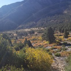
This trail has two points of entrance. You may start at Upper Bristlecone trail which begins at the top of Lee Canyon or you may start at Lower Bristlecone trail which begins just below. We have started on both sides and I prefer beginning at Lower Bristlecone trail and ending in Upper. The trail is more like a service road in the beginning. We were lucky to hike on a Monday morning where we encountered very few people. The trail can handle mountain bikes, horses, dogs, kids etc. Easy passing as you ascend up this slow climb. The trail continues on and on offering views of the valley below, the Lee Canyon ski area, and Mummy Mountain. We detoured off this trail and hiked a little bit of Bonanza Trail. We probably went about two miles and then stopped for lunch enjoying the pinyon and ponderosa pines for shade. Lots of beautiful wildflowers to sit amongst. We came back down and continued on our way. This trail loops all the way around till you reach an area of old Bristlecone trees. These trees tend to grow at 8000 feet and higher. I love viewing these trees as I always think of the stories they could tell when amongst them. This is the highest point of the trail and then you begin to descend down into the forrest. This is my favorite part of the hike as there are a couple of exquisite aspen groves to walk through. This time of year was perfect as they were flickering and singing as we walked through. At the base was a enchanting spread of wild ferns. When I saw the ferns I could picture us just stopping and taking a nap amongst these trees. As you wind through this portion of the trail, you will encounter plenty of happy birds and butterflies crossing your trail. The entire hike we calculated at about six miles. Level of difficulty I would rate as moderate. There were a couple of hills to climb but not overly difficult. You end up at the top of Lee Canyon and then you have to walk back to the Lower Bristlecone trail to pick up your car. I would highly recommend this trail in the spring, summer and definitely the fall to view the aspens turning. So glad we have this area to hike and leave all of our responsibilities behind even it is only for a day!

6 mile trail located in Lee Canyon. You can access the trail directly from the parking lot of the ski area. The terrain is mostly dirt but has some loose rocks. I would recommend hiking boots. The trail is easy to moderate in difficulty. We went on a Fall day and the changing leaves were beautiful. The best time to go is right at the end of September to see the peak of the leaves changing.

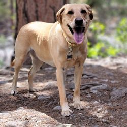
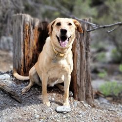
Just like many reviewers have stated, there are two entrances to the trail. I started on the lower bristlecone trail and worked my way up. The trail is 5 miles long but you need to walk a mile back to the car. This review is written by someone who is NOT a hiker. I don't think I am in excellent physical condition either...but if you are planning on completing the whole trail please be advised that it will take roughly 2-3 hours. Also, most of the trail is going up, so you will be walking on a hill most of the time. I recommend bringing water and good shoes. It is also a bit chilly up there so please consider taking a light jacket (I visited October). I went on a Friday and there were not a lot of people. I think I might have seen a total of 10 hikers. I took my dog with me and she loved it. Please be advised that the dog needs to be on a leash. Since there were not a lot of people I would let mine off the leash but quickly put her back in it if I saw other hikers. This hike has awesome panoramic views. I would definitely recommend it! I also wanted to point it that I saw a few children doing the trail as well...so I would assume it is kid friendly. Ps: the terrain is very rocky...good shoes are needed. A stroller would not fare well with this terrain.


Today couldn't have been a better time to hike up Bristlecone Trail. At 8,000 feet, my friend and I winded through this moderately strenuous trail non-stop for 2.5 hours, starting at the upper trailhead and ending 6-miles later at the lower trailhead, only to walk back uphill to the parking area. This trail had just the right amounts of shade as well as the right inclination fluctuations to work up a sweat but not come off as too strenuous. Late summer, early fall would probably be the best time to hike up here with temperatures plummeting down to about 73 degrees right at the uppermost parking lot that overlooks the ski area. (It probably goes further down as progress with the hike and I can assure you that you're going to feel the pressure in both your ears and your chest as elevations peak higher. My friend - shoutout to Vanessa! - said that she could feel her heart racing in her chest) Nonetheless, make sure you take a lot of water with you. This won't be the easiest hike there is, and if you decide to take breaks along the way, you could stay in the trail for as long as 4-5 hours. The lush pine and fir plant life was exuberating and I found myself lingering in my thoughts at how astounding nature was. With fall just around the corner, you could already detect the changes in leaf colors and I managed to get myself some pine leaves for home because they smelt so good. Great trail, great weather and company. Can't wait to check this place out once again one day.

Upper Bristlecone Trail is one of my favorite trails. The snow is gorgeous, the trail was great and the view up top is breathtaking!! I was in love and I didn't want to leave. I did sink a few times in the snow, but it was bound to happen. Few scratches on my ventures makes me look badass for sure. Haha. Watch out for snowboarders though! People do warn you when they're coming in, other than that, the trail was easy. I did go off trail to go up a steeper part for the challenge, and it was still worth it. I took my go pro, my canon and phone camera and took a bunch of pictures! I like to do all that as a hobby, so. Even bringing all my equipment for my picture taking needs, it was still fairly easy to go up. Nature's natural colors and nice cool breeze made it worth my hike. Meditated a bit up top and felt completely relaxed. Gorgeous. PS. Might have to pay $5 to park up there to do this trail since people also snowboard and ski. Worth it though! PSS. Bring your dog(s)! They'd love it

2 years ago
Awesome 6.5 mile hike! Beautiful views and peaceful trail. It's mostly flat with a bit of incline but nothing difficult, my son was able to keep up easily. There were alot of chill spots to have a quick snack break or take pics. The hike went by quickly and definitely didn't feel like 6+ miles. Love Mt. Charleston! read more


3 years ago
We decided to hike the Bristlecone loop trail, which is around 6.5 miles in total. You can start this trail in two different ways. We chose to start from the Upper Trailhead and parked our car near the Lower Trailhead so that we could easily hop in our car at the end. I suggest taking this route only if you prefer tackling the toughest part with the steepest incline right at the beginning, like I do. Overall, let me tell you, the trail is absolutely stunning and offers a perfect blend of sunshine and shade. You'll come across plenty of trees along the way and a few amazing viewpoints about halfway through the hike. Get ready to take in the smell of clean, fresh air and trees! Oh yeah! Don't forget to pack a picnic lunch and, of course, bring lots of water. Oh, and one more thing, this trail is dog-friendly! Now, when we started our hike, it was pretty crowded. Seems like most people show up around noon. If you can, I'd suggest coming earlier in the day on a weekend to avoid the crowd. Just a heads up: There aren't any restrooms on this trail, so plan accordingly. read more


5 years ago
This hike is by far my favorite on Mount Charleston! My fiancé and I came here last month and it snowed. We forgot our snow spikes for our shoes so we couldn't finish it. This time around we brought our snow shoe spikes, but didn't need it. There is a lot of parking! It is near the Lee Canyon's Ski Resort. In and out of the trail was about 4 miles. As we were hiking it didn't feel that long at all! There's a lot of beautiful sceneries as we hiked up.There was some snow on the mountains, which was amazing to see! There were also a few tepee looking shelters that people made! I thought that was cool! The trail has a variety of terrains; flats, uphills and downhills. This hike is not strenuous! It's great for families with kids and dogs as well! It was not busy at all! Hiking up and down felt very peaceful. We definitely escaped the city. The view was worth hiking up to! Happy trails! read more


As a big nature person and the mountains been the closest thing to green here in the lovely nevada , I can say I love this place beyond anything else . Many people that visit hardly know there's a green area to Nevada and maybe it's better or maybe not ? I love how tranquil and green and fresh it is up here but also wish to share this beautiful piece of heaven in the desert . All the mountain trails of mount Charleston are a must try ! I'm surprised I never did a review on this place but maybe I was too busy enjoying it The place is amazing to do a big hike , just a stroll on the lower canyon , perhaps a picnic with a beautiful view of wild horses and if your lucky enough , you get to see deer . This rainy season has surprised me so much compared to the past years . I recently started doing some mycology study and research and I decided to venture on the highest elevation and explore around , well .... here it's my biggest treasure find . Note : please never ingest anything you find on forest nor on floor , all this treasure was for research and for the love of nature and mycology . Foraging mushrooms do not interfere with mountain ecosystem , on the contrary , it helps the spores spread around , more life ! Many species are un edible to wild life and humans ( again ! Do not eat if you ain't sure of the ID ) . Besides finding and foraging we love hiking here all the time . My biggest recommendation is to please take your trash with you ! Take care of this place ! Have fun and enjoy it ! read more

 - Hiking Near Me - Mount Charleston, Nevada")


3 years ago
Beautiful trail to hike! It wasn't as steep as Cathedral Rock, kids enjoyed it as well. Trees just started to turn colors and just all in all a beautiful scenery. I wish they had more information on the trail like how far it was, yes it was our fault not to check it out but we were there mainly to check out the ski lift and the resto but decided to check out the hike also. We'll go back and we'll be ready next time! Ps Dog & whole family friendly! read more


3 years ago
7 years ago
Amazing, well marked trail with stunning views and some great elevation changes. The whole loop if you hike the lower an upper bristlecone is 5.7 miles. The trail is mountain bike and dog friendly so be sure to pay attention. We came super early in the morning so it wasn't very crowded. If you park at the upper bristlecone trailhead then you will have climbing to do at both the beginning and the end of the hike. If you prefer not to climb at the end of your hike, park down by the campgrounds or the lower bristlecone trailhead. We were able to see some of the local flora and fauna to include some wild horses on the trail. It was quite an experience! I will definitely be back when the aspens start to change in the Fall. read more


2 years ago
I have hiked Bristlecone Trail many times over the years. It's one of our hikes in the hot summer months when we escape the heat of the Las Vegas Valley and head to Mount Charleston to enjoy temperatures that are about 20 degrees cooler. The only thing about the hike that gets to you sometimes is the elevation. The hike starts at about 8,700 feet and reaches its high point at 9,400 feet. Along the way, you have some great views of the ski center, the aspen grove near the ski area, some bristlecone pines, and white pine. The first part of the hike is uphill. I normally do this hike by parking in the Lower Trailhead area and hike up the road to the Upper Trailhead. When I'm done, I'm back where I left the car. The second half of the hike is on an old Civilian Conservation Corps (CCC) road that was being built in the 1930s and 1940s. It was stopped as World War II started because the men were needed for soldiers, not road builders. At different times of the summer season, you can enjoy the trail in different ways. The aspen in the fall are quite nice. Early in the summer season, there will still be snow on Mount Lee above the ski area. The trail is also used by mountain bikers, especially on weekends, so you need to be on the lookout for them. read more


Bristlecone Trail (Mount Charleston, NV) Bristlecone Trail is one of my favorite hikes in Mount Charleston that do not involve a steep climb. I'm not stating that there's no incline. Bristlecone Trail is easier than Trail Canyon, Mary Jane Falls, and Cat Rock. Bristlecone Trail can be started from either the Lower or Upper Trailhead. Starting at the Upper Trailhead is easier since there's less hills to climb and the hike starts off in shade. The trail is marked well and easy to follow. There's not much of a peak. I bet that the views during January through March are amazing. Be on the lookout for wild horses. They frequent the area and we found the spot where they like to hang out. ADDITIONAL INFO & TIPS *Located in Mount Charleston *Directions from Las Vegas: 95 North, exit Lee Canyon, and just follow the road towards McWilliams (Lower Trailhead) *Parking at the Lower Trailhead or Upper Trailhead *Be prepared with enough hydration, good pair of shoes, and layers. Keep in mind it's about 20 degrees cooler than Vegas *Loop is about 7 miles *Pay attention for mountain bikers. *The wild horses play "possum" when they're spotted. They either hide behind a tree or freeze in place. I even witness some of them close their eyes thinking if they don't see us, we don't see them. Hilarious and cute at the same time. read more


Bristlecone Trail, you are a wonderland. The trees are tall, the air is clean, and the trail is easy. Come here to escape the heat of the valley (in the summer) and bask in nature. We've been here twice now and I can't wait to go back for more. Both times, we've encountered wild horses to gaze upon so if you're lucky, you will, too. The last trip up, we even saw deer and it was so amazing to be so close to them as they were right there next to the road. We park at the lower trailhead parking lot and just follow the loop around, which, in total, is about 6 or 7 miles once we walked back to our car. Schedule about two hours to be here if you do the whole loop. Bring snacks and hydration and please leave no trace i.e. don't litter. This is not a strenuous trail so feel free to bring your kids; you can always turn around and go back on the trail if they get too tired for the whole loop. Elevation at the top of the trail is more than 9,000 feet so you should bring a layer in the summer months if you get cold easily. I've started with a light jacket and then took it off as the warmth sets in. Happy hiking! read more


This trail has two points of entrance. You may start at Upper Bristlecone trail which begins at the top of Lee Canyon or you may start at Lower Bristlecone trail which begins just below. We have started on both sides and I prefer beginning at Lower Bristlecone trail and ending in Upper. The trail is more like a service road in the beginning. We were lucky to hike on a Monday morning where we encountered very few people. The trail can handle mountain bikes, horses, dogs, kids etc. Easy passing as you ascend up this slow climb. The trail continues on and on offering views of the valley below, the Lee Canyon ski area, and Mummy Mountain. We detoured off this trail and hiked a little bit of Bonanza Trail. We probably went about two miles and then stopped for lunch enjoying the pinyon and ponderosa pines for shade. Lots of beautiful wildflowers to sit amongst. We came back down and continued on our way. This trail loops all the way around till you reach an area of old Bristlecone trees. These trees tend to grow at 8000 feet and higher. I love viewing these trees as I always think of the stories they could tell when amongst them. This is the highest point of the trail and then you begin to descend down into the forrest. This is my favorite part of the hike as there are a couple of exquisite aspen groves to walk through. This time of year was perfect as they were flickering and singing as we walked through. At the base was a enchanting spread of wild ferns. When I saw the ferns I could picture us just stopping and taking a nap amongst these trees. As you wind through this portion of the trail, you will encounter plenty of happy birds and butterflies crossing your trail. The entire hike we calculated at about six miles. Level of difficulty I would rate as moderate. There were a couple of hills to climb but not overly difficult. You end up at the top of Lee Canyon and then you have to walk back to the Lower Bristlecone trail to pick up your car. I would highly recommend this trail in the spring, summer and definitely the fall to view the aspens turning. So glad we have this area to hike and leave all of our responsibilities behind even it is only for a day! read more


6 mile trail located in Lee Canyon. You can access the trail directly from the parking lot of the ski area. The terrain is mostly dirt but has some loose rocks. I would recommend hiking boots. The trail is easy to moderate in difficulty. We went on a Fall day and the changing leaves were beautiful. The best time to go is right at the end of September to see the peak of the leaves changing. read more


9 years ago
Just like many reviewers have stated, there are two entrances to the trail. I started on the lower bristlecone trail and worked my way up. The trail is 5 miles long but you need to walk a mile back to the car. This review is written by someone who is NOT a hiker. I don't think I am in excellent physical condition either...but if you are planning on completing the whole trail please be advised that it will take roughly 2-3 hours. Also, most of the trail is going up, so you will be walking on a hill most of the time. I recommend bringing water and good shoes. It is also a bit chilly up there so please consider taking a light jacket (I visited October). I went on a Friday and there were not a lot of people. I think I might have seen a total of 10 hikers. I took my dog with me and she loved it. Please be advised that the dog needs to be on a leash. Since there were not a lot of people I would let mine off the leash but quickly put her back in it if I saw other hikers. This hike has awesome panoramic views. I would definitely recommend it! I also wanted to point it that I saw a few children doing the trail as well...so I would assume it is kid friendly. Ps: the terrain is very rocky...good shoes are needed. A stroller would not fare well with this terrain. read more


8 years ago
Fantastic hike. We parked at the lower & hiked the 6/7mile? Loop. Gorgeous views. Will Definitely do this again in the spring. read more


14 years ago
Today couldn't have been a better time to hike up Bristlecone Trail. At 8,000 feet, my friend and I winded through this moderately strenuous trail non-stop for 2.5 hours, starting at the upper trailhead and ending 6-miles later at the lower trailhead, only to walk back uphill to the parking area. This trail had just the right amounts of shade as well as the right inclination fluctuations to work up a sweat but not come off as too strenuous. Late summer, early fall would probably be the best time to hike up here with temperatures plummeting down to about 73 degrees right at the uppermost parking lot that overlooks the ski area. (It probably goes further down as progress with the hike and I can assure you that you're going to feel the pressure in both your ears and your chest as elevations peak higher. My friend - shoutout to Vanessa! - said that she could feel her heart racing in her chest) Nonetheless, make sure you take a lot of water with you. This won't be the easiest hike there is, and if you decide to take breaks along the way, you could stay in the trail for as long as 4-5 hours. The lush pine and fir plant life was exuberating and I found myself lingering in my thoughts at how astounding nature was. With fall just around the corner, you could already detect the changes in leaf colors and I managed to get myself some pine leaves for home because they smelt so good. Great trail, great weather and company. Can't wait to check this place out once again one day. read more


10 years ago
Upper Bristlecone Trail is one of my favorite trails. The snow is gorgeous, the trail was great and the view up top is breathtaking!! I was in love and I didn't want to leave. I did sink a few times in the snow, but it was bound to happen. Few scratches on my ventures makes me look badass for sure. Haha. Watch out for snowboarders though! People do warn you when they're coming in, other than that, the trail was easy. I did go off trail to go up a steeper part for the challenge, and it was still worth it. I took my go pro, my canon and phone camera and took a bunch of pictures! I like to do all that as a hobby, so. Even bringing all my equipment for my picture taking needs, it was still fairly easy to go up. Nature's natural colors and nice cool breeze made it worth my hike. Meditated a bit up top and felt completely relaxed. Gorgeous. PS. Might have to pay $5 to park up there to do this trail since people also snowboard and ski. Worth it though! PSS. Bring your dog(s)! They'd love it read more


8 years ago
So much fun. My son and I completed the entire loop. I definitely recommend. Nothing strenuous at all. Great views! read more

10 years ago
8 years ago
6 miles of awesomeness : rated moderate only for the elevation - there is a 6 mile loop and you will sweat - I walked/jogged and finished just over 2 hrs stopping for great pics of course! I hikes solo and was lucky enough to spot 2 wild horses! Friendly people long the way too. Both the upper and lower loops have parking and a trail head - I parked at the upper and when I completed the loop walked back up the road to my car. Elevate your life - get out and hike! read more


8 years ago
7 years ago
A recent 2 mile hike starting from the lower Bristlecone trailhead. Some other people had already been out there with snow shoes, which would have been helpful. However it was still a great short hike in the snow. read more


11 years ago
With the fur baby in tow we decided to check out Bristlecone Trail. This ended up being a good trail to hit up when the weather was too hot in the Vegas valley. It's cooler up here on the mountain and the day we came the weather was perfect and the scenery was relaxing. It's about a 6 mile loop and there are tree stumps and logs that we sat on along the way when we wanted to have a break or just sit and look at nature. There were also people on bikes and some of them were courteous when passing and other zoomed by with no manners. I saw people of all ages and their fur babies on the trail. It's a somewhat easy hike, but there were times when the trail got steep. I'd recommend proper shoes since it was a bit slippery and naturally water. Elevation makes it a bit hard to breathe, but taking breaks every so often helped me a bit. I got a little chilly towards the end when the sun was going down, so I'd recommend having a light jacket just in case. There is parking at the lower trailhead. read more


The first time on this trail, we hiked the 6.3 mile loop, clockwise. We parked our car at the Lower Bristlecone Trailhead located off Route 156 Lee Canyon Road, just before McWilliams Campground Road. From the lower parking lot, we headed back towards Lee Canyon Road and headed up the asphalt road for about one mile to the Upper Bristlecone Trailhead parking lot at the ski resort. The trail immediately starts up a steady incline in the shade as you pass through the pine trees. In less than a half of a mile there is a nice log tree bench where you can take a short break before climbing the last 1.5 miles of elevation gain. At 3.3 miles from the lower parking lot, hiking clockwise, you reach the Bonanza Trailhead that takes off to the left (Northeast). Continue straight ahead, descending down Old Scout Canyon Road, a wide BOARING dirt road for the last 3 miles, all the way back down to the Lower Bristlecone Trailhead parking lot. As we hiked down that last 3 miles on that wide dirt road, I vowed to never hike this section again. Instead, I would park at the Upper Bristlecone Trailhead, hike to the Bonanza trail and take that until I decided to return back the same way, avoiding the lower trail all together. I rated this hike a four star only for the Upper Trail. read more


11 years ago
More info about Bristlecone Trail
Lee Canyon Rd
Mount Charleston, NV 89124
Directions
(702) 872-5486
Call Now
Visit Website
http://www.fs.usda.gov/htnf/
Hours
Indoor Amenities
Outdoor Amenities
Ask the Community - Bristlecone Trail
Review Highlights - Bristlecone Trail


Why does Yelp recommend reviews?
1 review that is not currently recommended
The reviews below are not factored into the business's overall star rating.
2 years ago
Bristlecone Trail - hiking - Updated July 2026
Best of Mount Charleston
People found Bristlecone Trail by searching for…
Campgrounds in Mount Charleston, Nevada
Things to Do With Kids in Mount Charleston, Nevada
Star Gazing in Mount Charleston, Nevada
Places to Take Pictures in Mount Charleston, Nevada
Parks in Mount Charleston, Nevada
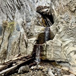
Hiking Trails With Waterfalls in Mount Charleston, Nevada
Picnic Areas in Mount Charleston, Nevada
Dog Friendly Parks in Mount Charleston, Nevada
Scenic View in Mount Charleston, Nevada
Off Road Trails in Mount Charleston, Nevada
Caves in Mount Charleston, Nevada
Easy Hikes in Mount Charleston, Nevada
Mountain Bike Trails in Mount Charleston, Nevada
Playgrounds in Mount Charleston, Nevada
Stroller Walk in Mount Charleston, Nevada
Lookout Points in Mount Charleston, Nevada
Dog Friendly Hiking Trails in Mount Charleston, Nevada
Camping Cabins in Mount Charleston, Nevada
Secret Spots in Mount Charleston, Nevada
Photo Spots in Mount Charleston, Nevada
Tent Camping in Mount Charleston, Nevada
Romantic Views in Mount Charleston, Nevada
Trending Searches in Mount Charleston, NV
Black Owned Nail Salons near Bristlecone Trail
Boat Rental near Bristlecone Trail
Cliff Jumping near Bristlecone Trail
Free Swimming Pool near Bristlecone Trail
Jet Ski Rental near Bristlecone Trail
Kayak Rental near Bristlecone Trail
Lakes & Ponds near Bristlecone Trail
Off Road Trails near Bristlecone Trail
Outdoor Activities near Bristlecone Trail
Parks For Picnics near Bristlecone Trail
Places To Swim near Bristlecone Trail
Pool Day Pass near Bristlecone Trail
Public Pools near Bristlecone Trail
Public Shower near Bristlecone Trail
River Swimming near Bristlecone Trail
Rock Quarry near Bristlecone Trail
Scenic Night View near Bristlecone Trail
Scenic Overlook near Bristlecone Trail
Secluded Spots near Bristlecone Trail
Soccer Store near Bristlecone Trail
Splash Pad near Bristlecone Trail
Swimming Holes near Bristlecone Trail
Swimming Lakes near Bristlecone Trail
Browse Articles
Browse Nearby
Browse Brands
Related Searches in Mount Charleston, NV
Affordable Kayak Rental Services in Mount Charleston, Nevada
Best Fishing Locations and Guides in Mount Charleston, Nevada
Best Places for Horseback Riding in Mount Charleston, Nevada
Best Sledding Spots and Fun in Mount Charleston, Nevada
Best Spots for Star Gazing in Mount Charleston, Nevada
Check Out Off Road Trails in Mount Charleston, Nevada
Discover Dog Friendly Trails to Explore in Mount Charleston, Nevada
Discover Lakes & Ponds to Explore in Mount Charleston, Nevada
Discover Top Nature Parks to Visit in Mount Charleston, Nevada
Discover the Best Night Hike Trails in Mount Charleston, Nevada
Dog-Friendly Hikes With Dogs in Mount Charleston, Nevada
Enjoy Camping Adventures Around Mount Charleston, Nevada
Enjoy Exciting Mountain Biking Adventures in Mount Charleston, Nevada
Enjoy Tent Camping Spots Around Mount Charleston, Nevada
Enjoy the Best Family Activities in Mount Charleston, Nevada
Enjoy the Best Tubing Experiences in Mount Charleston, Nevada
Enjoy the Best Walking Trails in Mount Charleston, Nevada
Explore Beautiful Botanical Gardens in Mount Charleston, Nevada
Explore Beautiful Parks and Green Spaces in Mount Charleston, Nevada
Explore Bike Rentals Throughout Mount Charleston, Nevada
Explore Easy Hikes Perfect for All in Mount Charleston, Nevada
Explore Free Things to Do Around Mount Charleston, Nevada
Explore Fun Activities to Do in Mount Charleston, Nevada
Explore Popular Campgrounds Near Mount Charleston, Nevada
Explore Popular RV Parks Around Mount Charleston, Nevada
Explore Scenic Lakes to Visit in Mount Charleston, Nevada
Explore Top Dog Parks in Mount Charleston, Nevada Near You
Explore Top Water Parks in Mount Charleston, Nevada Today
Explore the Best Beach Spots in Mount Charleston, Nevada
Explore the Best Boating Spots in Mount Charleston, Nevada
Explore the Best Swimming Holes Around Mount Charleston, Nevada
Family Friendly Hiking With Kids in Mount Charleston, Nevada
Find Fun Things to Do With Kids in Mount Charleston, Nevada
Find Parks and Recreation Activities in Mount Charleston, Nevada
Find Popular Ziplining Spots Around Mount Charleston, Nevada
Find the Best Parks for Picnics in Mount Charleston, Nevada
Find the Best Playgrounds to Visit in Mount Charleston, Nevada
Find the Best Scenic View Locations in Mount Charleston, Nevada
Hiking Trails With Waterfalls in Mount Charleston, Nevada
Must-See Tourist Attractions Around Mount Charleston, Nevada
Off Leash Dog Hiking Trails in Mount Charleston, Nevada
Perfect Spots to Watch Sunset in Mount Charleston, Nevada
Popular Kids Activities in Mount Charleston, Nevada
Popular Things to Do in Mount Charleston, Nevada
Safe and Fun Parks for Kids in Mount Charleston, Nevada
Top Playgrounds for Kids to Enjoy in Mount Charleston, Nevada
Top Running Trails to Explore in Mount Charleston, Nevada
Top Swimming Spots and Pools in Mount Charleston, Nevada
People who viewed Bristlecone Trail also viewed
Cathedral Rock
71 reviews
Sawmill Trail
7 reviews
Griffith Peak Trail
8 reviews
Lone Mountain
82 reviews
Northwest
Raintree via North Loop
10 reviews
Deer Creek Trailhead
4 reviews
Escarpment Trail
2 reviews
Spring Mountain Ranch State Park
157 reviews
Mt. Charleston
45 reviews
Peccole Ranch Walking Trail
57 reviews
South Summerlin, Westside