Turtlehead Peak Photos


You might also consider
More like Turtlehead Peak
Recommended Reviews - Turtlehead Peak
Start your review...

Reviews With Photos
This is not the ordinary person's hike trail. That belongs to professional mountaineer. Well if you want to try. There are some advices: Be there early, ware long pant. Hat -Protect your head no shade. Free your hands Mountain shoes. There are 70% of vertical trails waiting for you. charge your phone .Use google or hike APP to help you down hill. So don't lost in the mountain. There are wrong trails everywhere. People on yelp reviewed said turtlehead peak is ok or hard trail . I think you can go with heartbreak or hopeless. Cus After this turtlehead trail you won't feeling your legs ankles , legs hands shoulders are fulfill with scratches.You will find hope when you finished turtlehead peak and sitting in your car on the way home. Then you should shouting loudly to the stupid crow which always fly above your head" stupid B*** "Cus I did. About turtlehead view . It's beautiful.


Difficulty: Medium to Hard Mileage: ~5 Pets: Dog friendly View: Red Rocks Mountains, Las Vegas What to bring: At least 1-3 liters (depend on year), snacks, hat Parking: Lot below Fee: $17 park entrance for the day or National Park Pass, need reservations to enter in the park or pay $2 extra ($15 entrance + $2 = $17) as of 11/2020 Time: ~2.5-3 hours It was a good hike. We did it on 11/14, fall weather is bearable! The weather was perfect! We didn't need too much water because it wasn't blazing hot. The first mile was an easy stroll. The second mile was the hardest and that's because we went up the wrong way. We didn't follow the trail because we followed another hiker. They went up the steep way. It was challenging. Lots of loose rocks, so be careful not to slide and slip. Follow the trail! Don't make our mistake. Look for white or red or green markers on the rocks. We didn't know or see some markings and did a more challenging off trail route. We did make it up though. A little snow close to the top. Views were amazing! Beautiful. You can see all of Las Vegas and the beautiful red rocks canyons. Took us about 2.5 hours with resting at the top to admire the view.

This hike has a lot of pluses and minuses. As many people have said, this is definitely one of the more difficult hikes at Red Rock. Even though it isn't anywhere near as long as some of the other peak hikes, you do gain elevation aggressively. The peak itself is around 6,000 feet and you have to climb about 2000 of that- mostly in a little over a mile. Some of the major pros are: *You can get a good workout *Interesting views leading up to the base *Fantastic views of all of red rock and the strip *Sense of accomplishment Some of the major cons are: *Very poorly marked trail once you actually get to the base (I lost the trail multiple time. Some people have spray painted blue, orange, and white dots to help you which is the only way I found the top) *The trip down can be pretty treacherous (sandy steep slopes with lots of loose gravel) *Very exposed to direct sun (which was fine the day I went but would suck in the summer) These are of course my opinions. I like to hike, and have done many trails around red rock. This one was definitely the hardest I've done. My muscles are really sore! All in all, this hike took me about 3 hours. The hike itself is about 5 miles from the parking lot to the top and back... I definitely went a little longer as I lost the trail for a while. I can say I climbed a mountain now! Lol If I were to do this trail again, I would definitely bring someone with me and bring trekking poles for the way down!

In A Nutshell: -If you are looking for a very challenging hike, look no further than Turtlehead Peak. -Situated on the edge of the Mohave Desert & only a few minutes from downtown Las Vegas, you'll find this awesome canyon. -You should plan accordingly before you tackle this hike. -I suggest you wake up & start early (I started at 7:30am). -It took me 2 hours and 45 minutes from start to finish, this includes spending 20 minutes admiring the scenery. -You'll start easy, but once you get near the base, things become "rocky" & steep fast. -Signage is far & few between, so make sure you have some sort of sense of direction. -Your cellphone will get spotty signal, but once you get up top, you'll have 4G. -Bring lot's of water to stay hydrated & food like apples & bananas. -Once you made it up top, you'll enjoy some beautiful views of Red Rock Canyon, downtown Las Vegas & the blue sky! Overall, this is a great hike, well worth the effort. Go early to enjoy peace & quiet!

I've been making more of an effort to get out in nature, now that the hellacious temperatures of our summer season have come to pass. Turtlehead Peak is one of the tougher options at Red Rock, and I would say the difficulty rating is accurate. I went with a colleague who has done the trail before and has lots of hiking experience, which helped to avoid some of the navigation issues others mention. If you plan to make it all the way to the summit, allow about 3 hours. The trail was pretty visible, with rocks marked with white and blue dots as needed, up until the last quarter mile or so up to the ridge, which was more difficult. After the halfway mark, the terrain is rocky with gravel and sand stone, so wear shoes with good traction and consider gloves. It goes without saying to take adequate water and snacks or a lunch for the top, and watch out for cactus. As the photos show, the views are great. What I liked most about this particular trail is that it's difficult enough that it's not crowded and you mostly get the place to yourself. This hike will test your stamina; take breaks as needed and foam roll out your calves later!

This is by far one of my favorite trails to have hiked. The views from the top are so worth how strenuous the journey is. Yes this is not by any means an easy trail, it is DIFFICULT. If you haven't been to red rock before, there's one entrance where you pay the entry fee of $15. Military actually get in for free if you have an ID. After paying the $15 they'll give you a map and you find your trail. It's a one way road that leads you around a 15 mile loop that goes to each trail. Turtlehead Peak is I believe 4 on the map, don't quote me on that. But parking is easy, we went around 11am and it was pretty full. Turtlehead is shared with Calico Hills and another trail but they have signs to lead you. The beginning of the hike is just walking up a slight incline for about a mile nothing too crazy but it gets steep pretty quickly. Once you start going up the "mountain" they'll have white, red, or green markings on rocks to help navigate you up the trail. About halfway in it gets pretty gravely. I slipped a couple of times yikes. It took us about 2 hours to get all the way to the top. There wasn't many people we saw on the trail only a handful and most of the ended up turning back around the halfway mark. But the feeling of accomplishment you have at the end is completely worth it, oh and that view! The hike down was relatively easy, we did get lost for about 20 minutes so make sure to continually look for those white markers! It's kind of easy to get lost when going down. It took around an hour and half to get all the way down again. I wore a tank top, leggings, hat, and some Nike running shoes. Hiking shoes would have been more ideal but regular running shoes worked... definitely not converse or vans. It was hot when you're lower in elevation but once you get to the top of the peak it gets pretty cold and windy so a light jacket or wearing a thin long sleeve would be okay. I felt fine wearing a tank top though. Bring lots of water, we brought around 64oz for two of us and it lasted the whole hike. Also sunscreen because again you're gonna be in the sun for a duration of the hike! All in all this hike was amazing and I'm struggling to find other ones that are more challenging here in Vegas!

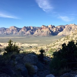
This is a difficult five mile round trip hike within the Scenic Drive at Red Rock Canyon. There is a 2,000 foot elevation gain over 2.5 miles. This hike should only be attempted by experienced hikers. You need hiking boots and a backpack with water and perhaps a snack or some protein bars. All that being said, the payoff of the view when you get to the peak is worth the work and pain of getting there. The trailhead is at the Sandstone Quarry parking area, the 3rd parking area along the Scenic Drive. From the west end of the parking lot, walk past the red and white sandstone that was left when the quarry closed in 1913, I think. There's evidence of their activity, and there are some interpretive markers to explain how they cut the stone and why they went bankrupt. The trail goes through a wash and then continues west. You come to a junction. To the right is the Calico Tanks trail. You need to go straight. Both trails are marked at the junction, about the last trail marker for Turtlehead. From then you start gaining elevation, slowly at first, and then more extreme. Eventually you reach the end of the sandstone formation and the trail cuts north. Now the going gets tougher. There are switchbacks to help with the elevation gain. In places, the gravel is quite loose--an excellent reason for wearing hiking boots. At this point, take a look up to the saddle to the left of Turtlehead. That's your first goal. There are two large boulders near the saddle and you should aim for them. There are a number of spider trails, but if you stay to the middle trails or slightly right, and keep going up, you're doing the right thing. The area gets very steep in places. The first time I hiked this, I stopped to catch my breath, and I started sliding backwards standing still. I never thought I'd make it, but I pressed on after a break. Eventually, you reach the saddle, and you have payoff number one. The view into Brownstone Canyon is simply awesome. The sandstone colors are truly beautiful and you feel almost on top of the world. But you're not--that's about to come. At the saddle, the trail goes right. This is the route up the back slope of Turtlehead that leads to the summit. Just like coming up the chute to the saddle, there are a number of trails that hikers have made. If you stay to the right, nearer to the edge, you will be taking the faster route, but I think it's a bit harder. Finally, you get to the summit and you are on top of your world. The 360 degree view is tremendous. Far off, you can see the Las Vegas Strip, and as you pivot, you look across Red Rock Canyon and see the tiny Scenic Drive. You can also see all the washes that run through the NCA. To the west, you have views of the Spring Mountains and Griffith Peak at Mount Charleston. Take the time to relax, sign the log book in an ammo box in some rocks near the highest point, have a snack, and take lots of photos. The peak is very large, so there's plenty of room there. To get back to the car, go down one of the trails from the summit keeping your eye out for those large boulders near the saddle. When you get there, you'll see where the trail descends. Take the downward part of the hike easy. This is very difficult, and sliding and falling is a distinct possibility. At the base of the chute, start breathing again, and get ready to have a big smile because you're almost done with your conquering of Turtlehead. Just over a mile to go the the parking area! Congratulations!! Happy hiking!

An incredibly rewarding hike! Going up seemed like it would never end (~2.5 miles up 2000 ft. in elevation), but the end was worth it. This trail is located inside Red Rock. You will have to pay $7 per car for entrance. The park is a 13 mile loop, but turn right and stay on the road till you've passed Calico II. The lot should be called Sandstone Quarry. It's not a huge lot, but we were able to find parking when we arrived around 730AM. It took us a total of 4 hours-ish to complete the trail. Definitely was a more difficult hike, but if our 21 pound schnauzer completed it, so can you! Okay, she hiked about 4 miles out of the 5, but she was able to make it to the top and half way down! The gravel on this trail is verryyyy loose so please come prepared with the appropriate shoes and walk down slowly. There are green and white dots that mark the path when you're almost to the top. They offer an option to go up the easy route or the difficult route 3/4 of the way up. We opted for the easy hike up. It's less incline and a further distance. We hiked the difficult trail down. It's shorter in distance, but had a steeper incline. Pick your poison I guess because the easy hike was still difficult. They have a little notebook at the top of the peak so you can sign and date your name. A cute thing that the park rangers do so keep a lookout for it. Overall, a really fun hike! A refreshing break from the traditional Vegas activities we usually do. We will definitely be back.

I almost gave this a "3" star rating only because the trail is difficult to navigate. But then, you can basically follow other favorite Mt trails and get to the same place. You can see your destination most of the time and make your own way there. The signs are good for the first mile and then it gets hard to stay on the main trail. Thankfully, someone painted markers in (now faded) orange and turquoise to assist with the trail. Towards the end, I started seeing white dots painted on the rocks and they assisted in staying on the trail. I would love to see these faded markers replaced with more permanent markers but know it costs money. Anyhow, once at the summit, the views are worth the hike. It'll be a difficult hike if you're not a hiker or if you're out of shape. If you are a hiker or in shape, it's still a decent workout.

This hike is about 5 miles out and back with about 2000 foot elevation gain. Although it may seem like an easy hike, you will ascend almost 1000 feet per mile, so be prepared for a strenuous hike, depending on your fitness level. The trail is single file with loose rocks under foot. There is a lot written about the lack of signage and clarity of which trail to take. I believe there must be new signs, since most of the trail was well marked and easy to follow. Only at the end was it a bit unclear. There is some rock scrambling and tough ascents, but the views are spectacular and worth the work. Also, the scenery is quite interesting along the way. parking - small lot, but ok to park on the street if full. $7 entrance fee to Red Rock Canyon
Holy Smokes Batman, this was quite the challenging and fulfilling hike! My hubby and I had been talking about doing this hike for quite sometime, but every time we were going to do it something came up. This time we planned to do it this past Sunday morning and I am so happy we did! We got up early and hit the trail by 7:30am. The trail is marked very well in the beginning and it starts out with a moderate climb. Once you get past a half mile, it all changes very quickly. You are climbing up, up, up! The trail is a mixture of gravel and rocks. There is also some rock scrambling involved. As you are climbing, watch for the rocks marked with the painted light blue/green circles. These help you to know you are staying on the main trail as there are several other paths that go off in other directions and it can throw you off. Once you reach the saddle, the views looking down are amazing from this vista. Brownstone Canyon is in front of you and you start to feel accomplished. No, not yet, keep going to the right as you still are not at the top. Now your adrenaline is really flowing, you are determined to get to the top and know you will. I kept checking my watch monitoring my heartbeat to determine just how hard I was working. You will see other people coming down on random paths that have been created we, however, stayed on the main trail wanting to respect this area and leave as little damage as possible. As we came around the corner after a bit more climbing, we were rewarded with another incredible view. This time a peak of the valley floor and the city but we still were not at the top. We made our last ascent and then we knew we made it. Thankfully, there was only us and two other people which made it very special. We made it over to the little trough that had a book in it to sign, an unopened beer bottle, dog collar and a few other trinkets. These were obvious mementos that previous hikers had left. I signed the book although the ink ran so who knows if my signature will remain. We spent at least an 1.5 hours up there taking in every view and enjoying an early lunch. My favorite view was facing the beautiful peaks of Red Rock and a snow capped Mt. Charleston in the distance. My watch determined it took us almost two hours to get to the top, this would be including rest breaks and there were many. The hike down is much more grueling and hard on the body. I came down the chute sideways trying to prevent myself from slipping, however, there were a couple of times when I still heard myself saying "WHOOOAAA" as I slipped a little. We met some cool people on our way up and up at the top but people were not quite as friendly going down. We continued to be friendly and encouraging knowing what they still faced. Once we got down to the bottom, I kept looking back up at the peak with a big smile across my face! So remember the following if you plan to conquer Turtlehead Peak: 1. WATER, WATER, WATER is a must (I couldn't believe the naive people that had one little bottle of water - What???? This is the desert people no matter what season it is! 2. Safety should be your main concern. Watch your footing. 3. This hike is not for beginners, it is HARD and difficult as other reviewers have stated. 4. I do not recommend this hike for young children under the age of ten. If you are plan on taking your kids, then be sure to watch them as there are edges where they can slip and fall. 5. Take snacks or sandwiches. Your body will thank you for the nourishment.

Welp, we finally climbed all the way up to the peak this morning and it was a doozy. Let me preface by saying that we didn't have plans to actually go all the way to the top today. We just headed to Sandstone Quarry to get some cardio done. The three choices we had were Calico Tanks, Turtlehead Peak, and Grand Circle trails. Since my partner in crime and I have already done Calico Tanks before and Grand Circle was way too long (11.4 miles round trip) we headed out on Turtlehead Peak trail with plans to see how far we could get in the time we had. This hike is rated as difficult and I would concur. My son does this hike all the time by himself and he's always been reluctant to take us with him because we would just slow him down. After doing this, I would agree with him. We weren't super slow, but we weren't fast, either. You are basically climbing the whole way to the peak. Some spots are easier than others, but the closer you get to the peak, the higher the inclines and the uneasier I felt. Why? Well, there are spots that are just gravel and combine that with steep inclines and narrow pathways means that it's easy to lose your footing and slip. Thankfully none of that happened today, but I did fall on my behind once but I was bracing myself on a big tree branch when it happened: no blood, no foul. Mel C. was wearing his Garmin so we knew that it took us 80 minutes to make it to the peak from the parking lot. That was 80 minutes of moving time; he would stop his watch when we were taking breaks, which happened a few times so we could catch our breaths and/or hydrate. I recommend bringing layers of clothing, hydration, snacks, and gloves if you are going to attempt this hike during the winter. We encountered snow at the top, too. Luckily, there was another hiker that we were following to the top and we followed his footsteps when we got to the snowy part because the trail kind of got buried underneath the snow. The signage on the trail is fairly good and easy to follow, but there's nothing when you get to the actual peak so look out for the trail that has a border with rocks on the left side of you as you keep ascending. The views are spectacular and we reveled in our accomplishment because we didn't think we'd actually make it today. This is not an easy hike and I would caution those who want to do it to take your time, watch your footing, and bring the right supplies. Going down the mountain is not simple, either. Again, it's easy to slip on the gravel as you descend. Even just getting your foot stuck on a crag can lead to a head-first tumble so be safe, but have fun. We did it and our calves and knees can attest to it!

This was a uniquely special hike for me and while I normally hike in a group; I did this by myself.... But my safety net was I had friends waiting at the bottom just in case I needed help. Never hike alone, folks! The hike itself... stunning. I am terrible with directions and although the trail was well labeled throughout I still kinda got lost. However, there are plenty of people around so it was easy to right the course. I hiked early so there was plenty of shade. This is also inside the Red Rock loop so a reservation or a local hook up is required - I was lucky to have a local hookup and got in for free. So stunning and beautiful. There are parts that are moderately challenging but slow and steady, like a turtle with get you there. Please come and create your own adventure. read more


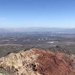
I've hiked nearly every trail at Red Rock Canyon NCA, and short of the Grand Circle Loop which is just challenging for its long distance (looping the interior perimeter of the entire park), Turtlehead Peak Trail is by far the most challenging hike inside the park. It's 4.6~ miles depending on if you don't lose the trail at any point (which is easy to do), you gain roughly 2,000ft of elevation and it can be fairly arduous depending on your fitness and preparedness level. It will cost you a $2 reservation fee, best purchased in advance, and if you do not have an America The Beautiful Nat'l Park Pass, an additional $20 park entrance fee. With the pass the entrance fee is waved. You'll take the scenic loop upon entering the park, and when you reach the Sandstone Quarry parking area you will be at the trailhead. Parking is limited so you're best off arriving early unless you're lucky with parking. The trail starts out fairly mellow, until about the 1/4 mile mark, and then the incline begins and never really faulters. The trail slinks back and forth through the desert landscape but there isn't much in the way of shade, so this is best not attempted in the middle of summer. Southern Nevada summers break records and hiking in a fully exposed desert can become very dangerous very quickly. Regardless of time of year, remember to bring plenty of water for everyone in your group. There are times when you're scrambling up shale and sharp rocks, and the trail will become narrow at times so be careful. Some portions of the trail are loose rock on steep sections so keep this in mind and wear the proper footwear. Because there is next to no shelter from the sun, be sure to wear sunscreen and something to cover your face and neck. You'll eventually reach a ridge line of sorts around the 1.75 mile mark, and you're nearly there, but it gets fairly steep here. Almost there and when you make it you'll be rewarded by panoramic views of the scenic desert cliffs, the Las Vegas skyline, the nearby summit of Mount Charleston and on a clear day you can see Arizona. Remember the summit is only half way so relax for a few, take pictures, replenish with a snack and then head back down. Back at the bottom you'll find 2 pit toilets with hand sanitizer, and you can celebrate having done something pretty cool outdoors just a few miles from the Vegas Strip. read more


This review is for the Turtlehead Peak Trail which was a ~4.6 mile total round trip that took ~3.5 hours to complete. If you have an America The Beautiful annual pass, it will cost $2 to enter. Impressive views of the canyon all throughout the hike. Trail could be a little difficult to follow as you get near the peak; follow the AllTrails map if needed. No shade, rocky with small pebbles. Starts off flat and eventually becomes an incline all the way to the top. Short video of the hike for those interested! https://youtu.be/y3Pqkk-a5HA read more


3 years ago
This is not the ordinary person's hike trail. That belongs to professional mountaineer. Well if you want to try. There are some advices: Be there early, ware long pant. Hat -Protect your head no shade. Free your hands Mountain shoes. There are 70% of vertical trails waiting for you. charge your phone .Use google or hike APP to help you down hill. So don't lost in the mountain. There are wrong trails everywhere. People on yelp reviewed said turtlehead peak is ok or hard trail . I think you can go with heartbreak or hopeless. Cus After this turtlehead trail you won't feeling your legs ankles , legs hands shoulders are fulfill with scratches.You will find hope when you finished turtlehead peak and sitting in your car on the way home. Then you should shouting loudly to the stupid crow which always fly above your head" stupid B*** "Cus I did. About turtlehead view . It's beautiful. read more


5 years ago
One of the more challenging trails at Red Rock but the views are amazing and Turtlehead is definitely worth the climb! read more


Difficulty: Medium to Hard Mileage: ~5 Pets: Dog friendly View: Red Rocks Mountains, Las Vegas What to bring: At least 1-3 liters (depend on year), snacks, hat Parking: Lot below Fee: $17 park entrance for the day or National Park Pass, need reservations to enter in the park or pay $2 extra ($15 entrance + $2 = $17) as of 11/2020 Time: ~2.5-3 hours It was a good hike. We did it on 11/14, fall weather is bearable! The weather was perfect! We didn't need too much water because it wasn't blazing hot. The first mile was an easy stroll. The second mile was the hardest and that's because we went up the wrong way. We didn't follow the trail because we followed another hiker. They went up the steep way. It was challenging. Lots of loose rocks, so be careful not to slide and slip. Follow the trail! Don't make our mistake. Look for white or red or green markers on the rocks. We didn't know or see some markings and did a more challenging off trail route. We did make it up though. A little snow close to the top. Views were amazing! Beautiful. You can see all of Las Vegas and the beautiful red rocks canyons. Took us about 2.5 hours with resting at the top to admire the view. read more


7 years ago
This hike has a lot of pluses and minuses. As many people have said, this is definitely one of the more difficult hikes at Red Rock. Even though it isn't anywhere near as long as some of the other peak hikes, you do gain elevation aggressively. The peak itself is around 6,000 feet and you have to climb about 2000 of that- mostly in a little over a mile. Some of the major pros are: *You can get a good workout *Interesting views leading up to the base *Fantastic views of all of red rock and the strip *Sense of accomplishment Some of the major cons are: *Very poorly marked trail once you actually get to the base (I lost the trail multiple time. Some people have spray painted blue, orange, and white dots to help you which is the only way I found the top) *The trip down can be pretty treacherous (sandy steep slopes with lots of loose gravel) *Very exposed to direct sun (which was fine the day I went but would suck in the summer) These are of course my opinions. I like to hike, and have done many trails around red rock. This one was definitely the hardest I've done. My muscles are really sore! All in all, this hike took me about 3 hours. The hike itself is about 5 miles from the parking lot to the top and back... I definitely went a little longer as I lost the trail for a while. I can say I climbed a mountain now! Lol If I were to do this trail again, I would definitely bring someone with me and bring trekking poles for the way down! read more


In A Nutshell: -If you are looking for a very challenging hike, look no further than Turtlehead Peak. -Situated on the edge of the Mohave Desert & only a few minutes from downtown Las Vegas, you'll find this awesome canyon. -You should plan accordingly before you tackle this hike. -I suggest you wake up & start early (I started at 7:30am). -It took me 2 hours and 45 minutes from start to finish, this includes spending 20 minutes admiring the scenery. -You'll start easy, but once you get near the base, things become "rocky" & steep fast. -Signage is far & few between, so make sure you have some sort of sense of direction. -Your cellphone will get spotty signal, but once you get up top, you'll have 4G. -Bring lot's of water to stay hydrated & food like apples & bananas. -Once you made it up top, you'll enjoy some beautiful views of Red Rock Canyon, downtown Las Vegas & the blue sky! Overall, this is a great hike, well worth the effort. Go early to enjoy peace & quiet! read more


9 years ago
I've been making more of an effort to get out in nature, now that the hellacious temperatures of our summer season have come to pass. Turtlehead Peak is one of the tougher options at Red Rock, and I would say the difficulty rating is accurate. I went with a colleague who has done the trail before and has lots of hiking experience, which helped to avoid some of the navigation issues others mention. If you plan to make it all the way to the summit, allow about 3 hours. The trail was pretty visible, with rocks marked with white and blue dots as needed, up until the last quarter mile or so up to the ridge, which was more difficult. After the halfway mark, the terrain is rocky with gravel and sand stone, so wear shoes with good traction and consider gloves. It goes without saying to take adequate water and snacks or a lunch for the top, and watch out for cactus. As the photos show, the views are great. What I liked most about this particular trail is that it's difficult enough that it's not crowded and you mostly get the place to yourself. This hike will test your stamina; take breaks as needed and foam roll out your calves later! read more


7 years ago
This is by far one of my favorite trails to have hiked. The views from the top are so worth how strenuous the journey is. Yes this is not by any means an easy trail, it is DIFFICULT. If you haven't been to red rock before, there's one entrance where you pay the entry fee of $15. Military actually get in for free if you have an ID. After paying the $15 they'll give you a map and you find your trail. It's a one way road that leads you around a 15 mile loop that goes to each trail. Turtlehead Peak is I believe 4 on the map, don't quote me on that. But parking is easy, we went around 11am and it was pretty full. Turtlehead is shared with Calico Hills and another trail but they have signs to lead you. The beginning of the hike is just walking up a slight incline for about a mile nothing too crazy but it gets steep pretty quickly. Once you start going up the "mountain" they'll have white, red, or green markings on rocks to help navigate you up the trail. About halfway in it gets pretty gravely. I slipped a couple of times yikes. It took us about 2 hours to get all the way to the top. There wasn't many people we saw on the trail only a handful and most of the ended up turning back around the halfway mark. But the feeling of accomplishment you have at the end is completely worth it, oh and that view! The hike down was relatively easy, we did get lost for about 20 minutes so make sure to continually look for those white markers! It's kind of easy to get lost when going down. It took around an hour and half to get all the way down again. I wore a tank top, leggings, hat, and some Nike running shoes. Hiking shoes would have been more ideal but regular running shoes worked... definitely not converse or vans. It was hot when you're lower in elevation but once you get to the top of the peak it gets pretty cold and windy so a light jacket or wearing a thin long sleeve would be okay. I felt fine wearing a tank top though. Bring lots of water, we brought around 64oz for two of us and it lasted the whole hike. Also sunscreen because again you're gonna be in the sun for a duration of the hike! All in all this hike was amazing and I'm struggling to find other ones that are more challenging here in Vegas! read more


This is a difficult five mile round trip hike within the Scenic Drive at Red Rock Canyon. There is a 2,000 foot elevation gain over 2.5 miles. This hike should only be attempted by experienced hikers. You need hiking boots and a backpack with water and perhaps a snack or some protein bars. All that being said, the payoff of the view when you get to the peak is worth the work and pain of getting there. The trailhead is at the Sandstone Quarry parking area, the 3rd parking area along the Scenic Drive. From the west end of the parking lot, walk past the red and white sandstone that was left when the quarry closed in 1913, I think. There's evidence of their activity, and there are some interpretive markers to explain how they cut the stone and why they went bankrupt. The trail goes through a wash and then continues west. You come to a junction. To the right is the Calico Tanks trail. You need to go straight. Both trails are marked at the junction, about the last trail marker for Turtlehead. From then you start gaining elevation, slowly at first, and then more extreme. Eventually you reach the end of the sandstone formation and the trail cuts north. Now the going gets tougher. There are switchbacks to help with the elevation gain. In places, the gravel is quite loose--an excellent reason for wearing hiking boots. At this point, take a look up to the saddle to the left of Turtlehead. That's your first goal. There are two large boulders near the saddle and you should aim for them. There are a number of spider trails, but if you stay to the middle trails or slightly right, and keep going up, you're doing the right thing. The area gets very steep in places. The first time I hiked this, I stopped to catch my breath, and I started sliding backwards standing still. I never thought I'd make it, but I pressed on after a break. Eventually, you reach the saddle, and you have payoff number one. The view into Brownstone Canyon is simply awesome. The sandstone colors are truly beautiful and you feel almost on top of the world. But you're not--that's about to come. At the saddle, the trail goes right. This is the route up the back slope of Turtlehead that leads to the summit. Just like coming up the chute to the saddle, there are a number of trails that hikers have made. If you stay to the right, nearer to the edge, you will be taking the faster route, but I think it's a bit harder. Finally, you get to the summit and you are on top of your world. The 360 degree view is tremendous. Far off, you can see the Las Vegas Strip, and as you pivot, you look across Red Rock Canyon and see the tiny Scenic Drive. You can also see all the washes that run through the NCA. To the west, you have views of the Spring Mountains and Griffith Peak at Mount Charleston. Take the time to relax, sign the log book in an ammo box in some rocks near the highest point, have a snack, and take lots of photos. The peak is very large, so there's plenty of room there. To get back to the car, go down one of the trails from the summit keeping your eye out for those large boulders near the saddle. When you get there, you'll see where the trail descends. Take the downward part of the hike easy. This is very difficult, and sliding and falling is a distinct possibility. At the base of the chute, start breathing again, and get ready to have a big smile because you're almost done with your conquering of Turtlehead. Just over a mile to go the the parking area! Congratulations!! Happy hiking! read more


An incredibly rewarding hike! Going up seemed like it would never end (~2.5 miles up 2000 ft. in elevation), but the end was worth it. This trail is located inside Red Rock. You will have to pay $7 per car for entrance. The park is a 13 mile loop, but turn right and stay on the road till you've passed Calico II. The lot should be called Sandstone Quarry. It's not a huge lot, but we were able to find parking when we arrived around 730AM. It took us a total of 4 hours-ish to complete the trail. Definitely was a more difficult hike, but if our 21 pound schnauzer completed it, so can you! Okay, she hiked about 4 miles out of the 5, but she was able to make it to the top and half way down! The gravel on this trail is verryyyy loose so please come prepared with the appropriate shoes and walk down slowly. There are green and white dots that mark the path when you're almost to the top. They offer an option to go up the easy route or the difficult route 3/4 of the way up. We opted for the easy hike up. It's less incline and a further distance. We hiked the difficult trail down. It's shorter in distance, but had a steeper incline. Pick your poison I guess because the easy hike was still difficult. They have a little notebook at the top of the peak so you can sign and date your name. A cute thing that the park rangers do so keep a lookout for it. Overall, a really fun hike! A refreshing break from the traditional Vegas activities we usually do. We will definitely be back. read more

8 years ago
I almost gave this a "3" star rating only because the trail is difficult to navigate. But then, you can basically follow other favorite Mt trails and get to the same place. You can see your destination most of the time and make your own way there. The signs are good for the first mile and then it gets hard to stay on the main trail. Thankfully, someone painted markers in (now faded) orange and turquoise to assist with the trail. Towards the end, I started seeing white dots painted on the rocks and they assisted in staying on the trail. I would love to see these faded markers replaced with more permanent markers but know it costs money. Anyhow, once at the summit, the views are worth the hike. It'll be a difficult hike if you're not a hiker or if you're out of shape. If you are a hiker or in shape, it's still a decent workout. read more


9 years ago
This hike is about 5 miles out and back with about 2000 foot elevation gain. Although it may seem like an easy hike, you will ascend almost 1000 feet per mile, so be prepared for a strenuous hike, depending on your fitness level. The trail is single file with loose rocks under foot. There is a lot written about the lack of signage and clarity of which trail to take. I believe there must be new signs, since most of the trail was well marked and easy to follow. Only at the end was it a bit unclear. There is some rock scrambling and tough ascents, but the views are spectacular and worth the work. Also, the scenery is quite interesting along the way. parking - small lot, but ok to park on the street if full. $7 entrance fee to Red Rock Canyon read more


Holy Smokes Batman, this was quite the challenging and fulfilling hike! My hubby and I had been talking about doing this hike for quite sometime, but every time we were going to do it something came up. This time we planned to do it this past Sunday morning and I am so happy we did! We got up early and hit the trail by 7:30am. The trail is marked very well in the beginning and it starts out with a moderate climb. Once you get past a half mile, it all changes very quickly. You are climbing up, up, up! The trail is a mixture of gravel and rocks. There is also some rock scrambling involved. As you are climbing, watch for the rocks marked with the painted light blue/green circles. These help you to know you are staying on the main trail as there are several other paths that go off in other directions and it can throw you off. Once you reach the saddle, the views looking down are amazing from this vista. Brownstone Canyon is in front of you and you start to feel accomplished. No, not yet, keep going to the right as you still are not at the top. Now your adrenaline is really flowing, you are determined to get to the top and know you will. I kept checking my watch monitoring my heartbeat to determine just how hard I was working. You will see other people coming down on random paths that have been created we, however, stayed on the main trail wanting to respect this area and leave as little damage as possible. As we came around the corner after a bit more climbing, we were rewarded with another incredible view. This time a peak of the valley floor and the city but we still were not at the top. We made our last ascent and then we knew we made it. Thankfully, there was only us and two other people which made it very special. We made it over to the little trough that had a book in it to sign, an unopened beer bottle, dog collar and a few other trinkets. These were obvious mementos that previous hikers had left. I signed the book although the ink ran so who knows if my signature will remain. We spent at least an 1.5 hours up there taking in every view and enjoying an early lunch. My favorite view was facing the beautiful peaks of Red Rock and a snow capped Mt. Charleston in the distance. My watch determined it took us almost two hours to get to the top, this would be including rest breaks and there were many. The hike down is much more grueling and hard on the body. I came down the chute sideways trying to prevent myself from slipping, however, there were a couple of times when I still heard myself saying "WHOOOAAA" as I slipped a little. We met some cool people on our way up and up at the top but people were not quite as friendly going down. We continued to be friendly and encouraging knowing what they still faced. Once we got down to the bottom, I kept looking back up at the peak with a big smile across my face! So remember the following if you plan to conquer Turtlehead Peak: 1. WATER, WATER, WATER is a must (I couldn't believe the naive people that had one little bottle of water - What???? This is the desert people no matter what season it is! 2. Safety should be your main concern. Watch your footing. 3. This hike is not for beginners, it is HARD and difficult as other reviewers have stated. 4. I do not recommend this hike for young children under the age of ten. If you are plan on taking your kids, then be sure to watch them as there are edges where they can slip and fall. 5. Take snacks or sandwiches. Your body will thank you for the nourishment. read more


6 years ago
Welp, we finally climbed all the way up to the peak this morning and it was a doozy. Let me preface by saying that we didn't have plans to actually go all the way to the top today. We just headed to Sandstone Quarry to get some cardio done. The three choices we had were Calico Tanks, Turtlehead Peak, and Grand Circle trails. Since my partner in crime and I have already done Calico Tanks before and Grand Circle was way too long (11.4 miles round trip) we headed out on Turtlehead Peak trail with plans to see how far we could get in the time we had. This hike is rated as difficult and I would concur. My son does this hike all the time by himself and he's always been reluctant to take us with him because we would just slow him down. After doing this, I would agree with him. We weren't super slow, but we weren't fast, either. You are basically climbing the whole way to the peak. Some spots are easier than others, but the closer you get to the peak, the higher the inclines and the uneasier I felt. Why? Well, there are spots that are just gravel and combine that with steep inclines and narrow pathways means that it's easy to lose your footing and slip. Thankfully none of that happened today, but I did fall on my behind once but I was bracing myself on a big tree branch when it happened: no blood, no foul. Mel C. was wearing his Garmin so we knew that it took us 80 minutes to make it to the peak from the parking lot. That was 80 minutes of moving time; he would stop his watch when we were taking breaks, which happened a few times so we could catch our breaths and/or hydrate. I recommend bringing layers of clothing, hydration, snacks, and gloves if you are going to attempt this hike during the winter. We encountered snow at the top, too. Luckily, there was another hiker that we were following to the top and we followed his footsteps when we got to the snowy part because the trail kind of got buried underneath the snow. The signage on the trail is fairly good and easy to follow, but there's nothing when you get to the actual peak so look out for the trail that has a border with rocks on the left side of you as you keep ascending. The views are spectacular and we reveled in our accomplishment because we didn't think we'd actually make it today. This is not an easy hike and I would caution those who want to do it to take your time, watch your footing, and bring the right supplies. Going down the mountain is not simple, either. Again, it's easy to slip on the gravel as you descend. Even just getting your foot stuck on a crag can lead to a head-first tumble so be safe, but have fun. We did it and our calves and knees can attest to it! read more


This is a Hike! Your looking at around 2 miles just to get to the base of the rock so bear that in mind when preparing yourself. The trail is labeled advanced, though I say if your fairly fit this is a doable, just bring plenty of water and a snack. The Vegas sun is not know for its kindness so also plan for that factor. Your going to be moving in steep and the angles only sharpen but no vertical claiming is required, just stamina. After the steep trek you are rewarded with a phenomenal View of the Entire Las Vegas Valley and all of Red Rock. When a friend and I hiked it we were pleased to run into snow at the top which only added to the feel and the cold was appreciated. Do not miss this trail during a visit to Red Rock! read more

This hike is definitely strenous. Its a day later and my legs hips and feet are sore. I do crossfit and hike regularly. The elevation and steepness of the climb got to me. The last quarter is uphill with lots of loose gravel. Its easy to get off trail but just keep going up and you will make it to the top. Its a beautiful view and well worth the hike. Spring is perfect time to go, I couldnt imagine doing that kinda hike in summer. There is no shade and you're sweating from. The road itself is also quite a lovely drive. We were fortunate enough to have a convertible and great weather. Gorgeous views all around. read more


11 years ago
My friends and I hiked this over Memorial Day weekend. It was easily the most difficult hike I've ever done, period. That made it even more gratifying to make it to the top but let me tell you, don't take this hike lightly. It really is dangerous and you need to be prepared with lots of water, snacks, the right shoes, and sunscreen. There is zero shade for most of the hike so don't try this one when it's really hot out. The elevation climb (over 2,000 feet in only 2.5 miles) is EXTREMELY taxing on your body and then you still have to worry about going down! One of my friends who is really afraid of heights couldn't finish the trail so keep that in mind if you have a severe fear of heights. The trail is not all that well-marked and it's very easy to get off track so only do this one with someone (preferably several someones) who knows how to get up and back. We ended up scaling the mountain rather than taking the trail itself, which I would only recommend if you are in really good shape and have great balance. With all of that being said, the views at the top are pretty amazing. Take some great selfies and don't forget to sign your name in one of the books in the geocache box at the top! This one isn't for the faint of heart... once was enough for me for sure! A rainstorm blew in while we were at the top, which made going down even more treacherous! read more


10 years ago
A great and difficult trail, it was unfortunate that I didn't get to sign the signature book when I was up there but I will be sure to do so when I go back! The trail starts with a slightly steep ascent and gradually increases to where you can feel the burns in your calves. A great work out nonetheless - if you're hiking Turtlehead in the winter expect to encounter snow and ice towards the last leg of your trek. I suggest bringing gloves, durable shoes, optional hiking sticks/pole for descent and last leg. read more


The best hike in the Red Rock Conservation Area! We spent several days in Vegas and had definitely planned on including several days of hiking during out stay in addition to the night life on the strip. The hiking provided a nice contrast to the bright lights and crowds of the strip. This is rated a "strenuous" hike thus be prepared. Bring water, snacks and proper shoes and attire. The hike was about 5 miles round trip but was very vertical! Very worth it! It had recently rained so part of the trail had been washed out but we were able to catch the trail at different parts. It starts out as gradual climb with some small bouldering but as you make it up the mountain you will need to use hands to climb up in sections. We started early and were able to avoid much of the heat. You climb through different rock strata starting with the red rock and making your way up to granite cliffs. Just when you think you are almost there it keeps climbing, but whoa! The view was amazing. You get an incredible view of the strip to the east and the entire red rock conservation area to the south. Don't forget to sign the GeoCache box at the top! read more


8 years ago
15 years ago
Breathtaking View! Probably one of the tougher hikes I've been on, but MAN do you feel exhilerated at the top! 2.5 miles nearly straight up, over shale (slippery rocks), and 2000+ feet elevation. I practically RAN down I felt so great afterwards. Warning - should be in pretty good shape for this one. Enjoy! read more

We were originally going to hike Calico Tanks and changed our plans once we saw the sign pointing in the direction of Turtlehead Peak. Mentally, I was prepared to do Calico Tanks, which is a pretty easy hike. I had to go from leisure mode to beast-mode with the quickness. The hike is as difficult as everyone stated in their reviews. The first .5 miles of the hike is flat and easy. The rest is 2 miles of torture. You'll definitely test your physical abilities, balance, and will power as your climb to the top. The trail is marked with a clear trail path, signs, spray paint markings, and even ribbon on branches. You'll hit a few switchbacks where you can get a little rest. We did the hike during the middle of winter and as we got closer to the top we had another obstacle...snow and ice. The trail became very difficult to follow because of the snow. I took advantage of the two other hikers that made it to the top before us. I used their footprints as a guide up. We finally made it to the top and the view was worth it. You get a full view of Red Rock Canyon, the Strip, and the Mt. Charleston area. I read a tip that you can even see Lake Mead on a clear day. We settled at the top, took our pictures, and admired the gorgeous views. The hike down is not easy either. The hike up tested my endurance and cardio. The hike down tested my balance and joints. I made sure to watch every step on the way down. As we got to the bottom, we greeted a bunch of hikers on the way up to Turtlehead Peak. They all looked cheerful and had huge Kool Aid smiles. Little do they know what lies ahead. Overall, I love this hike. I love everything about it. If you haven't done this hike before, then I suggest that you do your homework first. Be prepared for a long strenuous hike up and a great view from the top. TIP #1: Bring enough hydration, duh! TIP #2: Bring food to fuel you. TIP #3: Don't forget to sign the notebook at the top. We forgot!!! TIP #4: Don't yell "I'm the King of the world" when you're at the top. That's so 1997. TIP #5: Have fun and most importantly, be safe 2017 Hike Review #5 / 2017 Yelp Review #42 read more


This is a challenging hike to one of the most prominent peaks in the Red Rock Canyon area. You'll wanna be in half way decent shape if you're gonna go for this peak as it's a real work out. But the views are well worth it. read more

8 years ago
Hiked up Turtlehead Peak early Feb 2018. Gorgeous day 72 degrees and sunny. I am not an experienced hiker - I am mainly a trail runner from the Midwest. Much different terrain than this guy is used to. Overall, this was a fantastic experience. I just came with my running shoes and 40oz of Gatorade and I was able to complete this out and back in 2:15 minutes- started at 1pm on a Saturday. Long line to get in the park...probably was in line for 30 minutes. Lucked out I think with parking at the sandstone quarry lot. Immediately made my way on to trail figuring it may take my up to 4 hours. The trail will get somewhat confusing and less obvious the higher you get, but overall this was a great time. Excellent views not just at the top, but as you are getting there as well. It was more strenuous than I planned...legs were feeling it for sure. Be sure to remember that it is quite challenging coming down as well. Definitely making Red Rock a must go on my next Vegas visit. read more


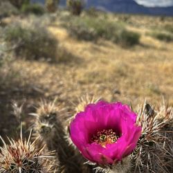
I have been climbing redrock canyon for more than a decade but I haven't tried this trail. I always pass by here but I have no idea how this hike is. We got there past 8am and started to navigate the trail while stopping in each and every beautiful flowers we saw to take pictures. We end up climbing a big rock on the left side to take pictures and while doing it we heard a rattle sound! I got scared! For the longest time I hike in redrock, that was the very first time I heard a rattle snake! Like everywhere else when you're in a National Park you need to be careful and be mindful at all times. We left that site immediately and proceeded to the turtlehead peak. It was a slow ascent during the first 20 minutes. We were enjoying the cold breeze and the warmth of the sun. We stopped in the first midsize rock on the middle of the path. We can see the turtlehead peak on the right, the sky was blue and the chemical rays are quite fabulous! In the meantime we didn't really know the end part of the hike as we have no map. We are basically just following the people hiking before us. After a few minutes, oh boy the trail was getting harder and harder. It became a vertical hike. The trail is quite rocky and loose. Some part are full of gravel. It's quite dangerous. We tried to look for another way where more stable rocks to climb on but we ended up in a steep spots. Stay on the trail, do not look for short cuts as there are none. You will end up in a more dangerous spots. Stop and rest, drink water and don't rush. Always take your time and phase. We finally arrived on the top big rock at the last curve heading to the peak. We sat behind that rock to rest and few steps away is a beautiful view of the Canyon. From there is another 20 minutes to the peak depending on your phase. It took us at least a couple of hours to the top. The view is amazing. If you will do this hike, come prepared and never give up. If your halfway, might as well finish it. It's well worth it. After the scenic view, the cool breeze and the warmth of the sun, going down is another thing. It is quite grueling and uncomfortable. I got blisters on my feet. Going downhill requires a great balance and control. While it was a steep incline going up, what can you expect going downhill! Make sure your hiking shoes is your best hiking shoes. It took as an hour to go down. It was a fun and challenging hike. If you love to hike and haven't tried this trail, I highly recommend but remember to come prepared, bring enough water and some snacks. Wear sunblock. Rest when you need to. This is not for older people who are frail and not fit. For an experienced hiker this is moderate but for others it is quite a strenuous hike. read more


It's been over or around 16 years since I last visited Turtlehead Peak (THP). My how the memories of my late 20's have seemed to fade. Back in the 90's, I bought Branch Whitney's, "Hiking Las Vegas." It was a book about 60 hikes within 60 minutes of the Strip. Back in the those days, the information in this book was pure gold. I sumitted THP a minimum of 2 times and a maximum of 3 times. Again, time escapes me so I cannot say for sure. The evening before May 9th, the GF, who has had THP on her bucket list for many years and I came up with a plan to conquer the peak. Armed with a newly purchased National Parks Pass, we arrived in the somewhat early morning hours. I was a bit taken back by the about of traffic on a Monday. Through the gate we went to the Sandstone Quarry parking lot. Again, I was taken back by the other vehicles already parked there. We prepped and I threw on my shoulders, the already field tested Tenzig. Bucket list check off for the GF....a training op for me (THHE). A quicker check of Whitney's publication, confirming what I thought I already knew about there being no trail but only a route to the summit, we followed the written words and proceeded as it instructed. Something seemed off. Something seemed amiss. Was it Father Time playing hell with my senses. Nothing seemed familiar to those days....now....so long ago. We would eventually make our way to the chute after trail blazing to it's base. The sounds of other hikers confirmed our suspicions we were in the right place. Up the chute we went. Beware....there are many trails. The only one that really matters is the one you are on that goes up. There was for a time a sequence of green dots painted on rocks. We assumed this was route. In retrospect, I am not sure when those dots were placed. All that mattered was the accent. Eventually, we would make it to the ridge line leading to the backside of the turtle. The backside was a little more radical than I remembered. I had told the GF once we made it to that point, it would be a gradual climb. Damn you Daddy Time! It was more of an angle than I remembered. Some two hours and forty-five minutes later we would find ourselves at the summit. The GPS had us at over 2000 feet of elevation gain in 2.5 (approximate) miles. The view from the top is one to behold.... You are actually above the many man-made whirly birds flying in the immediate area. Hearing swifts zoom by like Sidewinder missiles and performing organic aerobatics was better. We hung out for little while under the shadow of a Juniper Pine taking in the sights and sipping JetBoil tea. I also got to manipulate the Vortex spotting scope I was lugging around with me. We headed down after a while. Following the natural flow of things led us to a refined trail unlike the one we had followed up. There was no green dots. Just the a well defined path that took us down the chute above other hikers following the same route we had up. This particular path is the furthest right you can go heading down. If you're going up....it on the left. Once down from the chute, we followed an even more refined trail that actually had markers. This was not the book and must have been placed after its publication. One interesting observation I made was that 99% of the people we found on the trail up and down were friendly and returned our greetings. The closer we got to the parking lot, the more this type of courtesy became infrequent. I have a theory I will address when I write my Red Rock Conservation Area review. All in all, I absolutely recommend you check this off your list. I will say that regardless of the time of year....no summer....bring water. I passed several people going up and or coming down with no water! BRING WATER! Again, I have a theory about this to be addressed later. Respect & ENJOY!! Kudos to all those that have given a description of the experience and logistics of this amazing experience. read more

9 years ago
11 years ago
Turtle peak trail is the most craziest hike ive ever done! so hard and wanted to quit so many times. Had a billion panic attacks but all in all im glad to be in bed right now. I got brusies left and right but im so glad I did it. I even got to sign the in the books up there! That was my main goal. Ive only hiked 3 times im not a pro at all... scared of heights as welk!!! I weigh 210 lbs but guess what! I DID IT!!!!! So proud!!! read more

Turtle Head Peak is one of the more difficult trails at Red Rock Canyon. It is about 2 1/2 miles to the top. There is a lot of loose rocks and unstable footing along the trail. Once you get to the top though, you have a great view of the canyon. read more

Page 1 of 2
More info about Turtlehead Peak
Ask the Community - Turtlehead Peak
Review Highlights - Turtlehead Peak
You might also consider


Why does Yelp recommend reviews?
1 review that is not currently recommended
The reviews below are not factored into the business's overall star rating.
10 years ago
Turtlehead Peak - hiking - Updated July 2026
Best of Las Vegas
People found Turtlehead Peak by searching for…
Flower Fields in Las Vegas, Nevada
Lookout Points in Las Vegas, Nevada
Hiking Trails With Waterfalls in Las Vegas, Nevada
Rock Quarry in Las Vegas, Nevada
Swimming Holes in Las Vegas, Nevada
Night Hike in Las Vegas, Nevada
Make Out Spot in Las Vegas, Nevada
Dog Friendly Trails in Las Vegas, Nevada
Places to Take Pictures in Las Vegas, Nevada
Off Road Trails in Las Vegas, Nevada
Things to Do in Las Vegas, Nevada
Easy Hikes in Las Vegas, Nevada
Scenic Night View in Las Vegas, Nevada
Photo Spots in Las Vegas, Nevada
Lakes & Ponds in Las Vegas, Nevada
Picnic Areas in Las Vegas, Nevada
Playgrounds in Las Vegas, Nevada
Scenic Drive in Las Vegas, Nevada
Natural Hot Springs in Las Vegas, Nevada
Rattlesnake in Las Vegas, Nevada
Trending Searches in Las Vegas, NV
Black Owned Nail Salons in Las Vegas, NV
Cliff Jumping in Las Vegas, NV
Dog Friendly Trails in Las Vegas, NV
Jet Ski Rental in Las Vegas, NV
Lakes & Ponds in Las Vegas, NV
Off Road Trails in Las Vegas, NV
Outdoor Activities in Las Vegas, NV
Places To Walk Around in Las Vegas, NV
Pool Day Pass in Las Vegas, NV
Public Shower in Las Vegas, NV
River Swimming in Las Vegas, NV
Scenic Night View in Las Vegas, NV
Scenic Overlook in Las Vegas, NV
Secluded Spots in Las Vegas, NV
Strawberry Picking in Las Vegas, NV
Swimming Holes in Las Vegas, NV
Browse Articles
Browse Nearby
Browse Brands
Related Searches in Las Vegas, NV
Best Dog Hiking Trails Around Las Vegas, Nevada
Best Fishing Locations and Guides in Las Vegas, Nevada
Best Places for Horseback Riding in Las Vegas, Nevada
Best Sightseeing Experiences Available in Las Vegas, Nevada
Check Out Off Road Trails in Las Vegas, Nevada
Discover Dog Friendly Trails to Explore in Las Vegas, Nevada
Discover Popular Bike Trails in Las Vegas, Nevada
Discover Scenic Mountain Bike Trails Near Las Vegas, Nevada
Discover Walking Parks in Las Vegas, Nevada Near You
Discover a Hiking Trail in Las Vegas, Nevada
Discover the Best Night Hike Trails in Las Vegas, Nevada
Dog-Friendly Hikes With Dogs in Las Vegas, Nevada
Enjoy Camping Adventures Around Las Vegas, Nevada
Enjoy Exciting Mountain Biking Adventures in Las Vegas, Nevada
Enjoy Kayaking Adventures in Las Vegas, Nevada
Enjoy Off Leash Dog Hikes in Las Vegas, Nevada
Enjoy Scenic Places to Walk in Las Vegas, Nevada
Enjoy Tent Camping Spots Around Las Vegas, Nevada
Enjoy a Beautiful Waterfall Hike in Las Vegas, Nevada
Enjoy the Best Walking Path in Las Vegas, Nevada
Enjoy the Best Walking Trails in Las Vegas, Nevada
Explore Beautiful Parks and Green Spaces in Las Vegas, Nevada
Explore Easy Hikes Perfect for All in Las Vegas, Nevada
Explore Fun Activities to Do in Las Vegas, Nevada
Explore Popular Campgrounds Near Las Vegas, Nevada
Explore Popular Dog Walking Trails in Las Vegas, Nevada
Explore Top Dog Parks in Las Vegas, Nevada Near You
Explore Top Water Parks in Las Vegas, Nevada Today
Family Friendly Hiking With Kids in Las Vegas, Nevada
Find Parks and Recreation Activities in Las Vegas, Nevada
Find Popular Ziplining Spots Around Las Vegas, Nevada
Find the Best Parks for Picnics in Las Vegas, Nevada
Hiking Trails With Waterfalls in Las Vegas, Nevada
Off Leash Dog Hiking Trails in Las Vegas, Nevada
Perfect Spots to Watch Sunset in Las Vegas, Nevada
Picnic Areas With BBQ Pits Available in Las Vegas, Nevada
Plan a Scenic Drive Route Near Las Vegas, Nevada
Play at a Splash Pad Park in Las Vegas, Nevada
Popular Outdoor Activities to Try in Las Vegas, Nevada
Popular Picnic Spots to Visit in Las Vegas, Nevada
Safe and Fun Parks for Kids in Las Vegas, Nevada
Top Hiking Trails to Explore in Las Vegas, Nevada
Top Playgrounds for Kids to Enjoy in Las Vegas, Nevada
Top Running Trails to Explore in Las Vegas, Nevada
Top Swimming Lakes to Enjoy in Las Vegas, Nevada
Top Swimming Spots and Pools in Las Vegas, Nevada
Top Things to Do With Kids in Las Vegas, Nevada
Top-Rated Camping Sites in Las Vegas, Nevada