Big Falls Photos


You might also consider
Recommended Reviews - Big Falls
Start your review...

Reviews With Photos

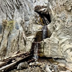
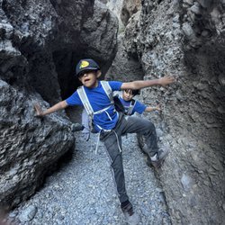
This is a strenuous trail that is not marked, not maintained, and will test your ability to scramble over rocks and boulders. The payoff can be worth it if there is a good flow from the falls. I have hiked this trail 7 times following the directions on the Bird and Hike website. You start at the Mary Jane Falls parking lot and walk out the trail toward Mary Jane. When you get to the first MJ Falls switchback, keep going straight and you'll be following a use trail and what is almost a gravel road. In a short distance, you come to a wash. Scramble down and up the other side. Look for the trail going through the wild currant bushes and you're on your way up the side canyon to Big Falls. Eventually this nice trial ends and you have to boulder scramble up the wash hiking around and/or over logs that have washed down. About 2/3 of the way up, you come to a blockage in the wash. The easiest way around is to go to the left and up the side ridge to bypass this obstacle. You can go to the right but it's steeper and there is more scree which makes your footing more difficult. After passing the obstacle, the trail drops down into the wash again and it continues on the right side of the canyon. You're nearly there now but there's still some uphill left. We usually don't do this hike unless we know there's some water. The most stunning time we hiked to Big Falls was in early July of 2011. That winter had been very wet on Mount Charleston and the snow was deep in the canyon. It was deep enough in fact that we hiked over the obstacle. It was like hiking on a glacier. The snow melt was going underneath the packed snow. It was an amazing day. Take care on returning. It is more difficult navigating boulders on your way down than climbing up. Sometimes as you're going down, you keep going until you land on something.

Big Falls trail is not for the faint of heart. It's an unmarked trail just past Mary Jane Falls trail in Mt. Charleston. Roundtrip, this hike took my group just under 3 hours to complete. We used directions from Bird and Hike to guide us. If you're okay with using geographical landmarks for directions and like a strenuous, off the beaten trail, then this hike is for you! After passing the Mary Jane Falls switchbacks, head left until you come across a wash that drops down a bit. If you look up across the ways you'll see a large mound of dirt and gravel - that's your cue to descend and head right and behind the mound, following the wash up. The wash is full of rocks, bushes, and felled logs. Climb over these until you run across a large boulder blocking your path with a hanging ladder. Do NOT use this ladder to get around - it's old and dangerous. Instead, 25 yards back is a steep rocky stairway you use to get around this obstacle. Keep going until you reach the waterfall. We went in July of 2016, so there was no water to speak of but you can definitely tell you've reached the "waterfall". Climb up the rocks to get a great view. From there, backtrack until you reach your original steps at the trail-head of Mary Jane Falls. We only seen two other hikers on the Big Falls trail. This is a great less traveled path to take in Mt. Charleston. *Not dog/kid friendly. http://www.birdandhike.com/Hike/Mt_Char/Big_Falls/_Big_Falls.htm YELP 100 CHALLENGE 2016: #52


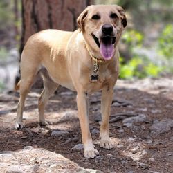
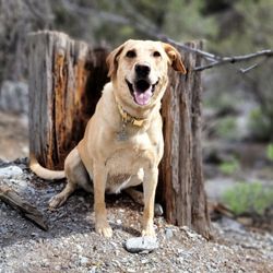
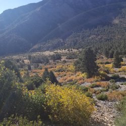
After wanting to do this hike for years, I finally got to go this morning with a friend leading the way. Since there isn't really an official trail to follow, I'm glad that I had someone who knew where to go. Even though it's June, there is still snow in parts of Mount Charleston due to the amount of rain that we had in the past few months. The snow is melting, so there was lots of water to see on this hike, which I loved. My friend, her dog, and I crossed quite a few areas with running water, so I was glad to have waterproof boots. It was also helpful to have hiking poles, as there were parts of the trek that they came in handy, notably when we encountered some snow to get to the falls. Big Falls itself did not disappoint; it's a beautiful sight! We had it to ourselves, too, which made this hike even better. We did see a couple of people on our way back to the parking area, but it's definitely not crowded like Mary Jane Falls or Cathedral Rock. Our hike was about 3.2 miles round-trip. Be advised that the amount of running water will depend on the weather and time of year; our timing was just right today. read more


I took my dog on this trail on Saturday at 7:15am and mostly had the trail to ourselves. We passed one couple coming down and about 15 minutes after we reached the top, a huge group of hikers came through, but otherwise, it was pretty calm and peaceful (unlike highly trafficked MJ Falls!). It was a little tricky finding the beginning of the trail after you split off from Mary Jane Falls trail at the switchbacks, but if you go left and keep left until you hit the wash, then you're basically all set to start heading up the wash until you reach some large boulder roadblocks. You can take some trails along the sides if you hit an obstacle in the wash, but it's pretty straight forward. Just keep walking upwards until you see a big waterfall :) read more


This is a strenuous trail that is not marked, not maintained, and will test your ability to scramble over rocks and boulders. The payoff can be worth it if there is a good flow from the falls. I have hiked this trail 7 times following the directions on the Bird and Hike website. You start at the Mary Jane Falls parking lot and walk out the trail toward Mary Jane. When you get to the first MJ Falls switchback, keep going straight and you'll be following a use trail and what is almost a gravel road. In a short distance, you come to a wash. Scramble down and up the other side. Look for the trail going through the wild currant bushes and you're on your way up the side canyon to Big Falls. Eventually this nice trial ends and you have to boulder scramble up the wash hiking around and/or over logs that have washed down. About 2/3 of the way up, you come to a blockage in the wash. The easiest way around is to go to the left and up the side ridge to bypass this obstacle. You can go to the right but it's steeper and there is more scree which makes your footing more difficult. After passing the obstacle, the trail drops down into the wash again and it continues on the right side of the canyon. You're nearly there now but there's still some uphill left. We usually don't do this hike unless we know there's some water. The most stunning time we hiked to Big Falls was in early July of 2011. That winter had been very wet on Mount Charleston and the snow was deep in the canyon. It was deep enough in fact that we hiked over the obstacle. It was like hiking on a glacier. The snow melt was going underneath the packed snow. It was an amazing day. Take care on returning. It is more difficult navigating boulders on your way down than climbing up. Sometimes as you're going down, you keep going until you land on something. read more


7 years ago
10 years ago
Big Falls trail is not for the faint of heart. It's an unmarked trail just past Mary Jane Falls trail in Mt. Charleston. Roundtrip, this hike took my group just under 3 hours to complete. We used directions from Bird and Hike to guide us. If you're okay with using geographical landmarks for directions and like a strenuous, off the beaten trail, then this hike is for you! After passing the Mary Jane Falls switchbacks, head left until you come across a wash that drops down a bit. If you look up across the ways you'll see a large mound of dirt and gravel - that's your cue to descend and head right and behind the mound, following the wash up. The wash is full of rocks, bushes, and felled logs. Climb over these until you run across a large boulder blocking your path with a hanging ladder. Do NOT use this ladder to get around - it's old and dangerous. Instead, 25 yards back is a steep rocky stairway you use to get around this obstacle. Keep going until you reach the waterfall. We went in July of 2016, so there was no water to speak of but you can definitely tell you've reached the "waterfall". Climb up the rocks to get a great view. From there, backtrack until you reach your original steps at the trail-head of Mary Jane Falls. We only seen two other hikers on the Big Falls trail. This is a great less traveled path to take in Mt. Charleston. *Not dog/kid friendly. http://www.birdandhike.com/Hike/Mt_Char/Big_Falls/_Big_Falls.htm YELP 100 CHALLENGE 2016: #52 read more


7 years ago
Excellent off the trail hike. It's close to the popular Mary Jane falls but not near as busy. It's a couple miles of creek bed so if you have bad knees don't come. At the end you will be at a raging water fall and will be able to see Mary Jane from there. read more

5 years ago
6 years ago
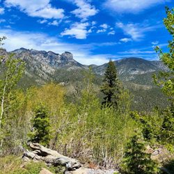
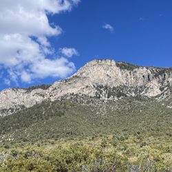
Part of the Mt. Charleston trail system, you'll find the path to this falls area to the left of the beginning of the "switchbacks" at Mary Jane Falls trail. Find parking in the large parking areas at the end of Kyle Canyon. Notice the big log which has been placed horizontally across the path to discourage weekend ramblers. Why? Because this trail is not maintained. Cross the log and follow the path as it veers left. You can then continue trying to negotiate your way through the wash, which entails a ton of boulder scrambling and log navigating, or search for and follow the original trails on the sides of the wash. Left side is better and less steep in places but the entire hike in is uphill. If you start from the Kyle Canyon parking lot it's about 4 miles all in and out. All Trails App has rated this moderate but in some places it can be very grueling and at times you literally are climbing the sides of the canyon hand over foot. This is definitely not a kid friendly trail! The prize at the end is worth it though! Giving it a four star review for right now because I wasn't able to plan properly given the AllTrails App information that I had so we didn't quite make it to the end because of the time constraint. read more


4 years ago
5 years ago
More info about Big Falls
Ask the Community - Big Falls
Review Highlights - Big Falls


Why does Yelp recommend reviews?
1 review that is not currently recommended
The reviews below are not factored into the business's overall star rating.
8 months ago
Big Falls - hiking - Updated July 2026
Best of Mount Charleston
People found Big Falls by searching for…
Things to Do in Mount Charleston, Nevada
Hiking Trails With Waterfalls in Mount Charleston, Nevada
Snow Play in Mount Charleston, Nevada
Scenic Views in Mount Charleston, Nevada
Fishing Spots in Mount Charleston, Nevada
Off Road Trails in Mount Charleston, Nevada
Caves in Mount Charleston, Nevada
Waterfalls and Swimming Holes in Mount Charleston, Nevada
Places to Take Pictures in Mount Charleston, Nevada
Star Gazing in Mount Charleston, Nevada
Scenic Overlook in Mount Charleston, Nevada
Waterfalls in Mount Charleston, Nevada
Dinosaur Park in Mount Charleston, Nevada
Beautiful Views in Mount Charleston, Nevada
Sand Dunes in Mount Charleston, Nevada
Lookout Points in Mount Charleston, Nevada
Hiking Groups in Mount Charleston, Nevada
Lakes & Ponds in Mount Charleston, Nevada
Secluded Spots in Mount Charleston, Nevada
Skyline View in Mount Charleston, Nevada
Tent Camping in Mount Charleston, Nevada
Creeks in Mount Charleston, Nevada
Trending Searches in Mount Charleston, NV
Black Owned Nail Salons in Mount Charleston, NV
Boat Rental in Mount Charleston, NV
Cliff Jumping in Mount Charleston, NV
Dog Swimming in Mount Charleston, NV
Free Swimming Pool in Mount Charleston, NV
Jet Ski Rental in Mount Charleston, NV
Kayak Rental in Mount Charleston, NV
Lakes & Ponds in Mount Charleston, NV
Off Road Trails in Mount Charleston, NV
Outdoor Activities in Mount Charleston, NV
Parks For Picnics in Mount Charleston, NV
Pool Day Pass in Mount Charleston, NV
Public Pools in Mount Charleston, NV
Public Shower in Mount Charleston, NV
River Swimming in Mount Charleston, NV
Rock Quarry in Mount Charleston, NV
Scenic Night View in Mount Charleston, NV
Scenic Overlook in Mount Charleston, NV
Secluded Spots in Mount Charleston, NV
Soccer Store in Mount Charleston, NV
Splash Pad in Mount Charleston, NV
Swimming Holes in Mount Charleston, NV
Swimming Lakes in Mount Charleston, NV
Browse Articles
Browse Nearby
BEST of Mount Charleston, Nevada Restaurants near Big Falls
BEST of Mount Charleston, Nevada Things to Do near Big Falls
BEST of Mount Charleston, Nevada Coffee near Big Falls
BEST of Mount Charleston, Nevada Picnic Areas near Big Falls
BEST of Mount Charleston, Nevada Breakfast near Big Falls
BEST of Mount Charleston, Nevada Campgrounds near Big Falls
Browse Brands
Related Searches in Mount Charleston, NV
Affordable Canoe Rental Options in Mount Charleston, Nevada
Best Dog Hiking Trails Around Mount Charleston, Nevada
Best Fishing Locations and Guides in Mount Charleston, Nevada
Best Places for Horseback Riding in Mount Charleston, Nevada
Best Sightseeing Experiences Available in Mount Charleston, Nevada
Check Out Off Road Trails in Mount Charleston, Nevada
Discover Dog Friendly Trails to Explore in Mount Charleston, Nevada
Discover Popular Bike Trails in Mount Charleston, Nevada
Discover Scenic Mountain Bike Trails Near Mount Charleston, Nevada
Discover the Best Night Hike Trails in Mount Charleston, Nevada
Dog-Friendly Hikes With Dogs in Mount Charleston, Nevada
Enjoy Camping Adventures Around Mount Charleston, Nevada
Enjoy Exciting Mountain Biking Adventures in Mount Charleston, Nevada
Enjoy Kayaking Adventures in Mount Charleston, Nevada
Enjoy Off Leash Dog Hikes in Mount Charleston, Nevada
Enjoy Tent Camping Spots Around Mount Charleston, Nevada
Enjoy the Best Walking Path in Mount Charleston, Nevada
Enjoy the Best Walking Trails in Mount Charleston, Nevada
Experience Stunning Sunset Views in Mount Charleston, Nevada
Explore Beautiful Parks and Green Spaces in Mount Charleston, Nevada
Explore Easy Hikes Perfect for All in Mount Charleston, Nevada
Explore Fun Activities to Do in Mount Charleston, Nevada
Explore Popular Campgrounds Near Mount Charleston, Nevada
Explore Popular Dog Walking Trails in Mount Charleston, Nevada
Explore Top Dog Parks in Mount Charleston, Nevada Near You
Explore Top Water Parks in Mount Charleston, Nevada Today
Explore the Best Beach Spots in Mount Charleston, Nevada
Explore the Best Swimming Holes Around Mount Charleston, Nevada
Family Friendly Hiking With Kids in Mount Charleston, Nevada
Find Cozy Camping Cabins in Mount Charleston, Nevada
Find Parks and Recreation Activities in Mount Charleston, Nevada
Find Top-Rated Waterfalls in Mount Charleston, Nevada Now
Find the Best Parks BBQ Grills in Mount Charleston, Nevada
Find the Best Parks for Picnics in Mount Charleston, Nevada
Find the Best Playgrounds to Visit in Mount Charleston, Nevada
Hiking Trails With Waterfalls in Mount Charleston, Nevada
Off Leash Dog Hiking Trails in Mount Charleston, Nevada
Picnic Areas With BBQ Pits Available in Mount Charleston, Nevada
Plan a Scenic Drive Route Near Mount Charleston, Nevada
Play at a Splash Pad Park in Mount Charleston, Nevada
Popular Outdoor Activities to Try in Mount Charleston, Nevada
Popular Picnic Spots to Visit in Mount Charleston, Nevada
Safe and Fun Parks for Kids in Mount Charleston, Nevada
Top Hiking Trails to Explore in Mount Charleston, Nevada
Top Playgrounds for Kids to Enjoy in Mount Charleston, Nevada
Top Running Trails to Explore in Mount Charleston, Nevada
Top Swimming Lakes to Enjoy in Mount Charleston, Nevada
Top-Rated Camping Sites in Mount Charleston, Nevada
Walk Dog Friendly Hiking Trails in Mount Charleston, Nevada
Walk the Best Paved Walking Trails in Mount Charleston, Nevada