Mummy Spring Trail Photos


You might also consider
More like Mummy Spring Trail
Recommended Reviews - Mummy Spring Trail
Start your review...

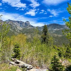
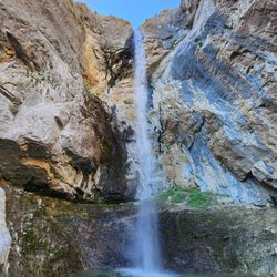
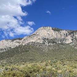
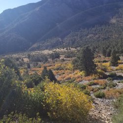
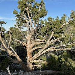
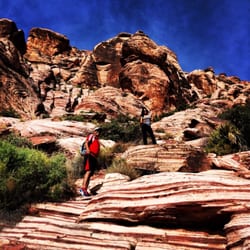
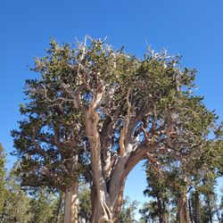
Mummy Springs Trail is a great cardio workout. It is an approximately 7.5 miles out and back trail beginning at the North Loop Trail. As you begin the ascent you are climbing quickly. The trail is really pretty filled with all kinds of beautiful bottlebrush and bristlecone pine trees along the way, and wildflowers everywhere. Many switchbacks that help you make your way up to the sky! The elevation gain is about 2,395 feet and believe me you will see just how high you are at the top of the North Loop. Nice view of the city too! Once you reach the top, you will veer slightly right and begin a slight downhill. You will be heading towards the Rain Tree which is the oldest tree alive in the Spring Mountains. As you reach the Rain Tree you will again veer right and head down the remaining trail to reach Mummy Springs. It is easy to miss and grateful that some other hikers gave us this tip. When you see a grove of aspen trees on your right, look up to the left and you will see the springs. You have to hike off the trail to reach the springs but you can hear them from the trail. We were up there in early September so there was really only a small trickle but it was consistent and it filled a pool. The water was so pure and clean. The area is rich with wild plants and flowers. Really healthy and green. We continued on the trail and found a great spot to sit and have lunch with Mummy's Toe as a backdrop. If you continue on this trail, the main trail ends but have read their are cairns set up that help you hike to the summit of Mummy's Toe. I would definitely recommend this hike for this site as well as viewing the Rain Tree. It is filled with some gorgeous views of the South Loop, Mummy's Toe, Lee Canyon and if you are feeling gutsy and strong, at the Rain Tree head left and hike the on up to the Mt Charleston Peak. So many options and trail choices in this area so what are you waiting for? Get outside! read more


So fun.. did this a couple of weeks ago. It's a bit of an uphill hike. Fairly long but beautiful views once you get up there. Beautiful bristlecone trees and towards the top there's still a bit of snow so be careful as it is pretty slippery uphill. Unfortunately we didn't reach the end because we weren't prepared for snow our shoes got wet read more


More info about Mummy Spring Trail
North Loop Trl
Mount Charleston, NV 89124
Directions
Hours
Outdoor Amenities
You might also consider


Mummy Spring Trail - hiking - Updated May 2026
Best of Mount Charleston
People found Mummy Spring Trail by searching for…
Things to Do in Mount Charleston, Nevada
Scenic View in Mount Charleston, Nevada
Romantic Views in Mount Charleston, Nevada
Beautiful Views in Mount Charleston, Nevada
Hiking Trails in Mount Charleston, Nevada
Scenic Restaurants in Mount Charleston, Nevada
Running Trails in Mount Charleston, Nevada
Snow in Mount Charleston, Nevada
Easy Hikes in Mount Charleston, Nevada
Walking Trails in Mount Charleston, Nevada
Running Routes in Mount Charleston, Nevada
Scenic Overlook in Mount Charleston, Nevada
Off Road Trails in Mount Charleston, Nevada
Waterfalls in Mount Charleston, Nevada
Sunset in Mount Charleston, Nevada
Parks for Pictures in Mount Charleston, Nevada
Trending Searches in Mount Charleston, NV
Bird Sanctuary near Mummy Spring Trail
Botanical Gardens near Mummy Spring Trail
Bounce House Rentals near Mummy Spring Trail
Campgrounds near Mummy Spring Trail
Florists That Deliver near Mummy Spring Trail
Flower Fields near Mummy Spring Trail
Flower Shop near Mummy Spring Trail
Free Picnic Areas near Mummy Spring Trail
Garage Sales near Mummy Spring Trail
Garden Center near Mummy Spring Trail
Golf Lessons near Mummy Spring Trail
Lakes & Ponds near Mummy Spring Trail
Mens Suits near Mummy Spring Trail
Nurseries & Gardening near Mummy Spring Trail
Outdoor Activities near Mummy Spring Trail
Outdoor Furniture Stores near Mummy Spring Trail
Party Equipment Rentals near Mummy Spring Trail
Pedicure near Mummy Spring Trail
Photo Spots near Mummy Spring Trail
Pokemon Go near Mummy Spring Trail
Rock Quarry near Mummy Spring Trail
Running Trails near Mummy Spring Trail
Spray Tanning near Mummy Spring Trail
Browse Articles
Browse Nearby
BEST of Mount Charleston, Nevada Restaurants near Mummy Spring Trail
BEST of Mount Charleston, Nevada Things to Do near Mummy Spring Trail
BEST of Mount Charleston, Nevada Coffee near Mummy Spring Trail
BEST of Mount Charleston, Nevada Picnic Areas near Mummy Spring Trail
BEST of Mount Charleston, Nevada Campgrounds near Mummy Spring Trail
BEST of Mount Charleston, Nevada Breakfast near Mummy Spring Trail
BEST of Mount Charleston, Nevada Shopping near Mummy Spring Trail
BEST of Mount Charleston, Nevada Hotels near Mummy Spring Trail
BEST of Mount Charleston, Nevada Glamping near Mummy Spring Trail
Browse Brands
Related Searches in Mount Charleston, NV
Affordable Kayak Rental Services in Mount Charleston, Nevada
Best Fishing Locations and Guides in Mount Charleston, Nevada
Best Places for Horseback Riding in Mount Charleston, Nevada
Best Sledding Spots and Fun in Mount Charleston, Nevada
Best Spots for Star Gazing in Mount Charleston, Nevada
Check Out Off Road Trails in Mount Charleston, Nevada
Discover Dog Friendly Trails to Explore in Mount Charleston, Nevada
Discover Lakes & Ponds to Explore in Mount Charleston, Nevada
Discover Top Nature Parks to Visit in Mount Charleston, Nevada
Discover the Best Night Hike Trails in Mount Charleston, Nevada
Dog-Friendly Hikes With Dogs in Mount Charleston, Nevada
Enjoy Camping Adventures Around Mount Charleston, Nevada
Enjoy Exciting Mountain Biking Adventures in Mount Charleston, Nevada
Enjoy Tent Camping Spots Around Mount Charleston, Nevada
Enjoy the Best Family Activities in Mount Charleston, Nevada
Enjoy the Best Tubing Experiences in Mount Charleston, Nevada
Enjoy the Best Walking Trails in Mount Charleston, Nevada
Explore Beautiful Botanical Gardens in Mount Charleston, Nevada
Explore Beautiful Parks and Green Spaces in Mount Charleston, Nevada
Explore Bike Rentals Throughout Mount Charleston, Nevada
Explore Easy Hikes Perfect for All in Mount Charleston, Nevada
Explore Free Things to Do Around Mount Charleston, Nevada
Explore Fun Activities to Do in Mount Charleston, Nevada
Explore Popular Campgrounds Near Mount Charleston, Nevada
Explore Popular RV Parks Around Mount Charleston, Nevada
Explore Scenic Lakes to Visit in Mount Charleston, Nevada
Explore Top Dog Parks in Mount Charleston, Nevada Near You
Explore Top Water Parks in Mount Charleston, Nevada Today
Explore the Best Beach Spots in Mount Charleston, Nevada
Explore the Best Boating Spots in Mount Charleston, Nevada
Explore the Best Swimming Holes Around Mount Charleston, Nevada
Family Friendly Hiking With Kids in Mount Charleston, Nevada
Find Fun Things to Do With Kids in Mount Charleston, Nevada
Find Parks and Recreation Activities in Mount Charleston, Nevada
Find Popular Ziplining Spots Around Mount Charleston, Nevada
Find the Best Parks for Picnics in Mount Charleston, Nevada
Find the Best Playgrounds to Visit in Mount Charleston, Nevada
Find the Best Scenic View Locations in Mount Charleston, Nevada
Hiking Trails With Waterfalls in Mount Charleston, Nevada
Must-See Tourist Attractions Around Mount Charleston, Nevada
Off Leash Dog Hiking Trails in Mount Charleston, Nevada
Perfect Spots to Watch Sunset in Mount Charleston, Nevada
Popular Kids Activities in Mount Charleston, Nevada
Popular Things to Do in Mount Charleston, Nevada
Safe and Fun Parks for Kids in Mount Charleston, Nevada
Top Playgrounds for Kids to Enjoy in Mount Charleston, Nevada
Top Running Trails to Explore in Mount Charleston, Nevada
Top Swimming Spots and Pools in Mount Charleston, Nevada