
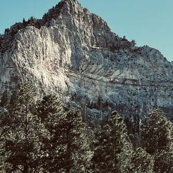
Cathedral Rock
Cathedral Rock Photos


You might also consider
More like Cathedral Rock
Recommended Reviews - Cathedral Rock
Start your review...

Reviews With Photos

We hiked Cathedral Rock Trail as part of my birthday weekend, and it was such a memorable experience! The trail is about 2.8 miles round trip and pretty much all uphill on the way to the top -- definitely a workout, but the panoramic views are 100% worth it. The weather was perfect, and the trail winds through beautiful forested areas with breathtaking scenery at every turn. We learned from another hiker that the trail had just reopened the day before after being closed for a long time due to damage from Tropical Storm Hilary in August 2023. Huge props to the crews who restored it -- the trail looked great and felt safe. The hike down is definitely quicker, but make sure you're wearing good hiking shoes. There are quite a few loose rocks, and it would be easy to slip if you're not careful -- especially on the steeper parts. Overall, this was a beautiful and rewarding hike. Highly recommend it if you're visiting Mt. Charleston and want something scenic but challenging!

Located in mount charleston. This place is relieving to the eyes if you need some greenery after being in Vegas and sick of all the hotels and buildings. The trails are beautiful and plenty of options. Fletcher, Mary Jane Falls and Big Falls are some of my favorite. Only an hour drive away from the big city. Love coming here for a chance to unwind and really decompress !!!

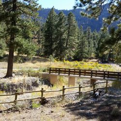
The view was amazing from the top. There's not very much parking so you may want to arrive early, before 8am. Summer 2023, is unusual because it was still 75 degrees in mid June. Usually it is already hot around June and you have a hard time hiking in June due to the heat. But the weather was comfortable. This is an easy hike, relatively speaking. The trail is a little rocky so watch your steps. They are dog friendly. They provide you doggie bags at the bottom of the trail. There were two public bathrooms at the bottom of the trail as well.

This hike is one of my favorites! Most of the way up is all incline, but I promise it is worth it for the views! On the way up you'll be raking on gravel, rocks and climbing up a few stairs. There are also rest benches where you can take a breather. When you get to the parking area, there are two parking lots. A mini lot and another lot once you get in. The two lots also have restrooms. When there's too many people and the stalls are full, you can park across the new condos and get a warm up in before the real hike. I definitely will be back here to get some exercise, escape the city and enjoy nature!

Loved this hike! If you want to cool off from The Vegas heat, take a trip up to Mt Charleston. There's a bunch of hiking trails. We decided to try a different hike and always heard about Cathedral Rock. Unfortunately, we didn't make it to the top since it was raining/hailing, but the views were breathtaking!

Great hike with a great prize when on top: magnificent scenery! It's pretty hard to walk up, but nothing bad if you're in good health. Plenty of rest along the way, and a nice waterfall too. Make sure to throw a snowball on the way! It took less than one hour up and half the way down. 50 minutes from the strip, so cool.

If you're looking for a short and moderately challenging hike with a satisfying payoff, go somewhere else. Just kidding! Cathedral Rock is all of those, packaged for me as a great introduction to Mt. Charleston hiking. This Friday morning started early with an arrival to the (free) parking lot around 7:30am - 8ish, and other hikers were already packing the lot quickly. The fitness requirement is a fairly moderate one as it is pretty much a gradual incline the entire way. But don't sweat too much, there are several benches along the way. Don't forget your water, your camera, and maybe a sack lunch. At the top is a great place for a lunch break and an Instagram opportunity. Had I come out a couple hours earlier, I bet the sunrise view would be breathtaking. Also at the top, there was a family of squirrels (close to 10) just looking for someone to drop a bit of food. Toward the edge that faces East, there's a hidden flat rock area that would be great for a small group. Watch your step and be careful! Do some trail homework ahead of time, because there are a few unmarked junctions that would make you second guess the path you took. If I thought in advance about doing a Yelp review, I would've photographed the trail markers.

Tip Top View ! I have been hiking Mt Charleston for over 25 years now , wow ! This trail has improved since the first time I did it , especially when you get to the end . It used to be pretty treacherous when you got to the top , now it has cutouts like steps when you get there , so much safer now . When you get to the top , you have a great view and you will have some visitors to greet you , chipmunks . They always show up to see if you have some spare trail mix . Large area to sit on the rocks and take in the view and have a snack before you head down . I wouldn't recommend doing this in the winter or any of the trails in bad weather . It is a great getaway from Vegas and usually about 30 degrees cooler .

There is nothing like getting some fresh air in the mountains and this trail right here is my favorite trail in Mt. Charleston! It is an easy and enjoyable hike. There is some incline (of course) but nothing too crazy. It is very doable! If you do get fatigued though, there are benches along the trail for you to rest on! I suggest getting to the parking spot early because by 7:30AM, it is already filling up especially during peak hiking season! Bring some protein bars or your favorite snacks, some water of course and wear good shoes! Other than that, enjoy the gorgeous views this trail has to offer and say hi to the chipmunks who will definitely greet you at the top!


Amazing trail. Steep incline most of the way, so just keep taking breaks at the benches on your way up. I did it with my dog and had a fine time navigating around other dogs on the trail. The view was gorgeous!!! This was a great workout. Oh and get there early, I arrived at 7:20am on a Sunday and both lots were already full.

We finally decided to hike this place for a change. We've been cooped up in the house for awhile and this trail is only 1 hr away from our place. My husband liked the walk but it's the climb (up and down) was a bit challenging for him. Plus the rocky path. His hips didn't lie. Gorgeous view and perfect temperature. We took our time going up and we had lots of photos taken. Few people along the way if you start a little early. We got there at 9am, started our hike at 9:30 and finished at 12:30 pm. Tips: wear comfy sneakers/clothing, apply some sunscreen, bring water and some snacks, fully charged phone for photoshoots, be early like 9/10am, come here on a weekday (weekend/holiday might be crowded), path is narrow so give way to those who are going down or let other pass you, there are paths that are rocky so please be careful, maintain social distancing and wear mask if there more people around. Don't forget to keep your trash with you when leaving the place. It was a fun nature hike. I definitely enjoyed the trail.

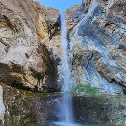
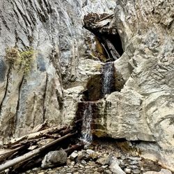
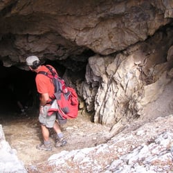
This was one of the trails open while everything else was shut down during COVID 19. I can't tell you how beautiful this place is, especially when you've been stuck in your house for 2 1/2 months! I took my son up during a week day and the trail was practically empty. A great place for those that live in Las Vegas to get away from the heat... it was literally 30 degrees cooler. The trail was a little challenging for my little one since you're going uphill, but he hung in there. We were able to see a little snow, some beautiful waterfalls, and even what looked to be a petrified tree. We will definitely be back to hike again!

1 month ago
Excellent hike in the Mt Charleston mountain area, about 40 minutes outside of Vegas. Ample parking lot but it was definitely packed and the restrooms were kind of gross and no TP. This is a popular hike so be prepared to see humans. This is about a 2.8 mile in and out hike with the hike to Cathedral Rock mainly all incline. You are def gonna work for the views but man it is so worth it. I definitely got my workout for the day and enjoyed the views once on top. The rock definitely looks like a cathedral, no joke. The climb back down pretty easy and took half the time to get up. Really nice hike and a memorable one. If you wanna get out of the city, this is a moderate hike that will get your heart pumping and the views are so sick! Loved it! read more


9 months ago
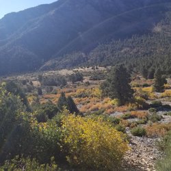
The hike to Cathedral Rock is gorrrrgous! Fall colors are so beautiful. It was 37 degrees when we arrived at 8am, and warmed up to 60ish. Very limited parking. Prepare yourself to park downhill and walk up. Restrooms are available in both parking lots and are real toilets. No soap. Lots of dogs on this day, and lots and lots of people on a Sunday. Take this hike! read more


1 year ago
We hiked Cathedral Rock Trail as part of my birthday weekend, and it was such a memorable experience! The trail is about 2.8 miles round trip and pretty much all uphill on the way to the top -- definitely a workout, but the panoramic views are 100% worth it. The weather was perfect, and the trail winds through beautiful forested areas with breathtaking scenery at every turn. We learned from another hiker that the trail had just reopened the day before after being closed for a long time due to damage from Tropical Storm Hilary in August 2023. Huge props to the crews who restored it -- the trail looked great and felt safe. The hike down is definitely quicker, but make sure you're wearing good hiking shoes. There are quite a few loose rocks, and it would be easy to slip if you're not careful -- especially on the steeper parts. Overall, this was a beautiful and rewarding hike. Highly recommend it if you're visiting Mt. Charleston and want something scenic but challenging! read more


2 months ago
Located in mount charleston. This place is relieving to the eyes if you need some greenery after being in Vegas and sick of all the hotels and buildings. The trails are beautiful and plenty of options. Fletcher, Mary Jane Falls and Big Falls are some of my favorite. Only an hour drive away from the big city. Love coming here for a chance to unwind and really decompress !!! read more


9 months ago
The view was amazing from the top. There's not very much parking so you may want to arrive early, before 8am. Summer 2023, is unusual because it was still 75 degrees in mid June. Usually it is already hot around June and you have a hard time hiking in June due to the heat. But the weather was comfortable. This is an easy hike, relatively speaking. The trail is a little rocky so watch your steps. They are dog friendly. They provide you doggie bags at the bottom of the trail. There were two public bathrooms at the bottom of the trail as well. read more


4 years ago
This hike is one of my favorites! Most of the way up is all incline, but I promise it is worth it for the views! On the way up you'll be raking on gravel, rocks and climbing up a few stairs. There are also rest benches where you can take a breather. When you get to the parking area, there are two parking lots. A mini lot and another lot once you get in. The two lots also have restrooms. When there's too many people and the stalls are full, you can park across the new condos and get a warm up in before the real hike. I definitely will be back here to get some exercise, escape the city and enjoy nature! read more


Loved this hike! If you want to cool off from The Vegas heat, take a trip up to Mt Charleston. There's a bunch of hiking trails. We decided to try a different hike and always heard about Cathedral Rock. Unfortunately, we didn't make it to the top since it was raining/hailing, but the views were breathtaking! read more

Great hike with a great prize when on top: magnificent scenery! It's pretty hard to walk up, but nothing bad if you're in good health. Plenty of rest along the way, and a nice waterfall too. Make sure to throw a snowball on the way! It took less than one hour up and half the way down. 50 minutes from the strip, so cool. read more


6 years ago
If you're looking for a short and moderately challenging hike with a satisfying payoff, go somewhere else. Just kidding! Cathedral Rock is all of those, packaged for me as a great introduction to Mt. Charleston hiking. This Friday morning started early with an arrival to the (free) parking lot around 7:30am - 8ish, and other hikers were already packing the lot quickly. The fitness requirement is a fairly moderate one as it is pretty much a gradual incline the entire way. But don't sweat too much, there are several benches along the way. Don't forget your water, your camera, and maybe a sack lunch. At the top is a great place for a lunch break and an Instagram opportunity. Had I come out a couple hours earlier, I bet the sunrise view would be breathtaking. Also at the top, there was a family of squirrels (close to 10) just looking for someone to drop a bit of food. Toward the edge that faces East, there's a hidden flat rock area that would be great for a small group. Watch your step and be careful! Do some trail homework ahead of time, because there are a few unmarked junctions that would make you second guess the path you took. If I thought in advance about doing a Yelp review, I would've photographed the trail markers. read more


1 year ago
Tip Top View ! I have been hiking Mt Charleston for over 25 years now , wow ! This trail has improved since the first time I did it , especially when you get to the end . It used to be pretty treacherous when you got to the top , now it has cutouts like steps when you get there , so much safer now . When you get to the top , you have a great view and you will have some visitors to greet you , chipmunks . They always show up to see if you have some spare trail mix . Large area to sit on the rocks and take in the view and have a snack before you head down . I wouldn't recommend doing this in the winter or any of the trails in bad weather . It is a great getaway from Vegas and usually about 30 degrees cooler . read more


4 years ago
There is nothing like getting some fresh air in the mountains and this trail right here is my favorite trail in Mt. Charleston! It is an easy and enjoyable hike. There is some incline (of course) but nothing too crazy. It is very doable! If you do get fatigued though, there are benches along the trail for you to rest on! I suggest getting to the parking spot early because by 7:30AM, it is already filling up especially during peak hiking season! Bring some protein bars or your favorite snacks, some water of course and wear good shoes! Other than that, enjoy the gorgeous views this trail has to offer and say hi to the chipmunks who will definitely greet you at the top! read more


We drove up here to do some hiking but unfortunately it is closed off and unlike a lot of other national parks or hiking areas, there's no way around it. Good there was other places around that were within reach from roadside parking. read more


Amazing trail. Steep incline most of the way, so just keep taking breaks at the benches on your way up. I did it with my dog and had a fine time navigating around other dogs on the trail. The view was gorgeous!!! This was a great workout. Oh and get there early, I arrived at 7:20am on a Sunday and both lots were already full. read more


2 years ago
We finally decided to hike this place for a change. We've been cooped up in the house for awhile and this trail is only 1 hr away from our place. My husband liked the walk but it's the climb (up and down) was a bit challenging for him. Plus the rocky path. His hips didn't lie. Gorgeous view and perfect temperature. We took our time going up and we had lots of photos taken. Few people along the way if you start a little early. We got there at 9am, started our hike at 9:30 and finished at 12:30 pm. Tips: wear comfy sneakers/clothing, apply some sunscreen, bring water and some snacks, fully charged phone for photoshoots, be early like 9/10am, come here on a weekday (weekend/holiday might be crowded), path is narrow so give way to those who are going down or let other pass you, there are paths that are rocky so please be careful, maintain social distancing and wear mask if there more people around. Don't forget to keep your trash with you when leaving the place. It was a fun nature hike. I definitely enjoyed the trail. read more


6 years ago
This was one of the trails open while everything else was shut down during COVID 19. I can't tell you how beautiful this place is, especially when you've been stuck in your house for 2 1/2 months! I took my son up during a week day and the trail was practically empty. A great place for those that live in Las Vegas to get away from the heat... it was literally 30 degrees cooler. The trail was a little challenging for my little one since you're going uphill, but he hung in there. We were able to see a little snow, some beautiful waterfalls, and even what looked to be a petrified tree. We will definitely be back to hike again! read more


8 years ago
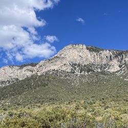
This is a pretty hike the whole way up. But be warned... it is STEEP. Between the trail and the elevation gain I was definitely huffing a little bit. But this is a good one if you want to get out of the vegas heat and get a workout in. The very top is a view looking down on the town and cathedral rock. Not my personal favorite hike, but still solid. read more


We were very pleased with our hike at Cathedral Rock yesterday as with every great hike, we worked to get there, but were rewarded with great views at the top. The trailhead is easy to find and the trail was easy to follow. There is a decent amount of traffic on the trail and usually a crowd at the top, but it wouldn't keep us from doing it again. Once the 45 minute process of waking up my teenage daughter and friend was complete, we headed out and arrived at the trail head parking around 8:45. Both upper and lower parking lots were full and we parked on the 157 below. Beware, that parking on the downhill side of the street is illegal and many cars were not ticketed, but marked on the windows by NHP. Parking on the street added about a quarter mile to the hike. The trailhead is demarcated with a large sign and other than a left turn to the main trail heading south around the rock, a right turn around a mile out at the crossing away from the falls, and a veer to the right to head to the switchbacks up to the top, the trail is easy to navigate made up of mostly limestone rocks for the first 3/4 of the trail and a combination of dirt and rocks for the final 1/4. Numbers don't lie here, 1000 foot elevation gain (starting at 7000 above sea level) over 1.4 miles equals 13.5% grade. And I know you don't need a math tutor, but 20 degrees cooler on the mountain still means it's 90 degrees if it's 110 in the valley, so get there early. We saw many younger children, older adults, and four legged friends struggling on the ascent when we were on our way down during the 12 o'clock hour. With an extra 30 pounds with my son in tow on my back. It took us just over an hour to get to the top with many breaks. The views at the top are definitely worth it as you can see Kyle Canyon and the Mount Charleston summit. There's no shade at the top and space can be limited if there is a crowd. It goes without saying to bring protection from the sun, plenty of water (3 bottles for me), and keep your distance from others on the trail. read more


7 years ago
My favorite hike in the LV area. It's challenging but short and rewarding. The hike itself is pretty shaded the whole way up, and you see lots and lots of beautiful foliage, trees, and wildflowers. It feels like you're in California and not Nevada. Such a gem for being free. Even waterfalls around. The top is such a beautiful view of all of the Mt. Charleston canyon. Well worth the hike. It's a big, flat, empty area great for picnics and pics and all of that good good. Drive to Mt. Charleston (exit 157) off the 95N, follow the road. After the hairpin turn at the end of the canyon, you'll see new signs directing you to the parking area. Both the upper and lower lots are easy to join the trail, but can be crowded and full. read more


2 years ago
5 years ago
Just a beautiful quaint place to be. We love the views and driving around seeing the cabins. read more

Totally beautiful spot. Having recently relocated from WA to NV, I have a high standard for natural beauty. I'm learning that the desert is a beautiful place as well but Mt/ Charleston is where I can go to get a little taste of home. I'll come here as often as possible. read more

This was a great hike for a hot Saturday in July. You can't beat the cooler temperatures and scenery at Mount Charleston. We followed Norm K.'s directions for accessing the trail and found it easily. There were two parking lots, one upper and one lower. They are the same distance from the start of the trail so you can park at either one. Both parking lots have bathrooms. For me the hike was a decent workout, but not too bad. The hike up to the top took us 38 minutes. Some have described the hike as fairly level, but it seemed to be an incline most of the way. The dirt and rock trail is well maintained. The trail is easy to follow with signs along the way to help guide you. There is a small stretch that narrows with a steep drop, but compared to other hikes I've done this is low on the danger scale. At the top the scenery is beautiful and definitely worth the hike. read more


5 years ago
During the Spring, Summer & Fall this is my go to place at least twice a week as it's only a short hike up to one of the most beautiful places within just a 45 minute drive from Vegas. If you're looking for an absolutely pristine locale to refresh the mind body and soul, look no further than here. Happy Trails & I'll see you out there! read more

Gorgeous hiking trail. Now is a great time to do it - butterflies out in force, sunshine through the leaves is heavenly, and there are fun critters scampering about the beautiful flowers. It's still imperative to social distance, so we arrived at the trail at 7a in order to avoid as many people as possible and beat the heat. Of course, I enjoyed taking photos and usually take my time on trails. Bring your mask for when you start to encounter others on the trail for some sections are flanked on either side by foliage and way too narrow for avoiding each other well. Per hiking etiquette + social distance, we would stop when we spotted people, put on our masks, and face the other way. In addition, when possible, we would walk off trail to give them a wide berth. Courteous, and I hope more people continue to so the same. The trail definitely becomes steep in places and a bit tiring. If you're not used to high altitude hiking, at this point you're over 8000 feet, just take frequent breaks. Your muscles are receiving less oxygen and there's no shame in resting every few feet if you have to. Bring lots of water! read more


I am beyond thrilled that this is in Vegas' backyard. About an hour away from the city, this is a literal, breath of fresh air if you're trying to get away from the hustle and bustle of Las Vegas. I met a friend at a Starbucks and we were on our way. The scenic views along the slightly windy road took my breath away. Mostly because they were beautiful, but also because I had to pinch myself a few times that this is part of my community! We did the Cathedral Rock route which is a beginner route if you're in decent shape. It took my crew about 45 minutes to get to the top. No matter what shape you're in though, don't stop until you make it to the peak. The views are spectacular. We started to climb around 8:15am and it wasn't too crowded on the mountain, even though the parking lot was almost full. I cannot wait to explore even more next tine! Who's with me?! read more


We went for a morning hike yesterday, it was a harder than we thought but everyone enjoyed the breathtaking views. First time taking our dog and to our surprise a lot of people brought their fur babies as well. Overall a nice 2 and some change miles hike, kid and pup friendly! Highly recommended! read more


8 years ago
Such a beautiful hike! When you think hiking do you think of sand and cacti? I don't! For those of you who don't enjoy hiking the desert through red rock trails, go to Mount Charleston! This hike was not too hard but still steep enough to get a good workout in. Perfect trail for our puppy, she loved running around leash free in this forest. It was pretty quiet when we went on a Tuesday evening. Saw about 2 other groups of people. Also saw a mini waterfall that was drying up. It can be pretty cold up here though so I recommend bringing a light track jacket just in case. It took us about an hour to walk up and a half to come down. Coming here is great, it'll feel like a little hideaway from the desert! read more


A good workout today here at Cathedral Rock Trail. It is about is 3 mile moderately strenuous out and back trail. To get there take US 95 north from Las Vegas to State Highway 157/Kyle Canyon Rd. Then turn left and follow the road to the Cathedral Rock parking area which is approximately 100 yards prior to the Mt. Charleston Lodge (you'll see the uphill road to the parking area directly ahead of you just prior to the lodge). The starting elevation will be 7,600 feet and gain about 1,000 feet over the course of the hike. It's an easy-to-follow trail the entire route with no scrambling. The trail starts off steep, flattens out some before you reach the top. It gets your heart pumping as you ascend. Once at the top, it offers some amazing views of Kyle Canyon and the small community of vacation homes there. I recommend at least a liter of water per person, some high energy snacks, binoculars, good hiking shoes, and a camera. read more


5 years ago
11 years ago
If you're looking for a way to beat the heat, here is your answer! Cathedral Rock Trail is one of the many trails on Mt Charleston. There is a good size amount of parking but can get pretty packed by afternoon. Convenient bathrooms are here that seem to be stocked and maintained. If you brought your furry friend, pet waste bags are also available at the beginning of the trail. This trail is only a few miles but gains quite a bit elevation. When you look at the top it seems so far away and a strenuous hike. On the contrary! I am not an avid hiker by any means and it only took us about 45 minutes to reach the top and 30 to make it down. That was with multiple stops for me to catch my breath. Several benches are along the way for rest or to take in the beautiful view. Once you reach the top you'll feel the sense of accomplishment and enjoy the scenery! For those of us who can't live without their phone, I did get a signal the entire hike up. As far as weather, it was about 30 degrees cooler than the Vegas area. A nice relief in the summer! read more


It's that time of year when the temps hit triple digits in the Vegas Valley which means it's also the time that we make regular escapes to cooler Mount Charleston. Cathedral Rock is one of our favorite trails because it's scenic and short, only about 35 minutes to the top. Along the way up, you are aided by a few stone steps and there are also benches for you to stop, have a seat, and enjoy the scenery. I do have to advise that you proceed with caution if you go with children, pets, or aren't exactly sober when you make the climb since there are no railings to prevent you from falling over the sides. The views at the top are fantastic and remind you why we're so fortunate to live so close to this beauty. read more


11 years ago
Cathedral rock trail is a gorgeous but difficult 3 mile round trip hike. Its basically a medium grade slope with a short/ flat respite towards the end (but right before you get to the top there's another steep section). There are beautiful views the entire way, and once you get to the top it's even more gorgeous! 360 view of the valley and mountains. you experience a wide variety of landscapes on this trail - from evergreens, to pine trees, to grassy/rocky meadows. There is one section that is super rocky/slidey and I can see that getting slippery if it's wet out. Other than that trail was pretty well maintained with some built in rock steps. It was a relatively cool day as compared to Vegas. We hiked in August. We got to the trailhead around 11am, and it was 85F at that point. The sun was hot, but there was wind thankfully, and some shade with benches to cool off in. Definitely bring lots of water & snacks. I brought my 32 oz nalgene, and almost finished it by the time I got to the top. I'd bring about 50 oz of water per person. It's hot, and you don't want to get heat exhausation. And I'm going to gripe here - when we got to the top there was a lot of trash and food scraps left from previous hikers. Don't be that person! Also, the top doesn't have a ton (or any) shade, so plan your hike early enough so you're not baking in the bright afternoon sun. Tip for your fur babies: We headed to the restaurant near the Cathedral Rock trailhead afterwards for a late lunch, and they had a dog menu! (Food is meh but that's another yelp review). They're so dog friendly that on weekends they have a deck reserved for people and their fur babies :) read more


When you read reviews and they say it's strenuous take people's word for it. I made the mistake of working out before doing the joke, so the struggle felt extra real. Majority of the hike is uphill. **tip: if you haven't hiked in awhile, don't go with super fit people or your calves will burn trying to keep up** Bring plenty of water, it might take awhile. The big plus about this hike is that it's not that bad to do in the summer due to the trees and shade. I refuse to hike anywhere but mount Charleston in summer, unless you want to die of heat stroke. When you feel like your legs are burning, just keep going because the view is definitely worth it. There's signs that'll lead you to the trail so it's not one of those hidden ones that are hard to find. Wear some comfy shoes and comfy pants. I saw someone in jeans and he was dying. read more


Page 1 of 2
More info about Cathedral Rock
2525 Kyle Canyon Rd
Spring Mountain National Recreation Area
Mt Charleston, NV 89124
Directions
Hours
Indoor Amenities
Outdoor Amenities
Ask the Community - Cathedral Rock
People are referencing directions posted by Norm K. Where can i find those?
Do I need to pay to access the trails?
No. The Spring Mountain Recreation Area is free of entrance fees except for camping and some picnic areas.
Review Highlights - Cathedral Rock


Cathedral Rock - hiking - Updated July 2026
Best of Mt Charleston
People found Cathedral Rock by searching for…
Things to Do in Mt Charleston, NV
Scenic Views in Mt Charleston, NV
Snow Play in Mt Charleston, NV
Hiking Trails With Waterfalls in Mt Charleston, NV
Scenic Overlook in Mt Charleston, NV
Playgrounds in Mt Charleston, NV
Off Road Trails in Mt Charleston, NV
Places to Take Pictures in Mt Charleston, NV
Abandoned Places in Mt Charleston, NV
Night View in Mt Charleston, NV
Waterfalls and Swimming Holes in Mt Charleston, NV
Free Parking in Mt Charleston, NV
Night Hike in Mt Charleston, NV
Lookout Points in Mt Charleston, NV
Waterfalls in Mt Charleston, NV
Beautiful Views in Mt Charleston, NV
Natural Hot Springs in Mt Charleston, NV
Easy Hikes in Mt Charleston, NV
Picnic Areas in Mt Charleston, NV
Watch Sunset in Mt Charleston, NV
Picnic Tables in Mt Charleston, NV
Browse Nearby
BEST of Mt Charleston, Nevada Parks near Cathedral Rock
BEST of Mt Charleston, Nevada Scenic View near Cathedral Rock
BEST of Mt Charleston, Nevada Things to Do near Cathedral Rock
BEST of Mt Charleston, Nevada Restaurants near Cathedral Rock
BEST of Mt Charleston, Nevada Coffee near Cathedral Rock
BEST of Mt Charleston, Nevada Caves near Cathedral Rock
BEST of Mt Charleston, Nevada Breakfast near Cathedral Rock
BEST of Mt Charleston, Nevada Campgrounds near Cathedral Rock
BEST of Mt Charleston, Nevada Visitor Centers near Cathedral Rock