Amargosa River Canyon
Amargosa River Canyon Photos


You might also consider
More like Amargosa River Canyon
Recommended Reviews - Amargosa River Canyon
Start your review...

7 months ago
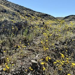
Enjoyed going thru this river and canyon on a side by side! We camp at Dumont Dunes and this is located in that vicinity. This river is an underground river but when it rains hard there's so much water on the trails it looks so cool! Such a great experience seeing this canyon! Totally recommend! read more


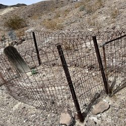
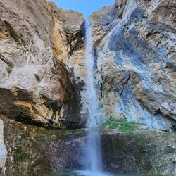
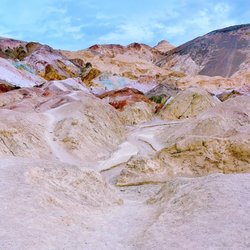
I have been hiking in the area for over a decade and it's always been a very special place--history, great geology, and a date shake--all are part of hiking here. The Amargosa Rover Canyon offers several trails in China Ranch and beyond. There are two ways to hike the canyon itself. The best way to enjoy most of the entire canyon is to spot cars. Leave one at China Ranch and drive the other to Tecopa, California and park where there's public parking behind the post office. From here, hike south following the trail. Mostly you'll hike on the railroad bed of the T&T Railroad (Tonopah and Tidewater) bed as it follows the Amargosa River through the canyon. At places, the trail leaves thew railroad bed and makes wide arcs on the east side of the trail. After 5 miles, you'll reach the turnoff for China Ranch and where the spur from the T&T was built to bring gypsum from the mines above the ranch from the Morrison Siding. Along the way through the canyon from Tecopa, you'll see areas with barbed wire. This is where horses and cattle were fenced in to keep them off the railroad tracks. You will see no track. The railroad stopped operating in 1940 and the rails were pulled up and used for World War II needs. About a mile and a half from the Ranch, there's a turnoff to the west (right) and this leads to a little waterfall on the river. Beyond this about 1/4 mile, there's another turnoff--again to the west--that leads to a slot canyon that is blocked by a huge chockstone. Both side trails have signs but they have faded a lot over the years. When you almost reach the 90º bend in the river, the trail goes up a hill and heads east (left) toward the ranch. Before going up the hill, take time to look at the wood left from when this was where the gypsum was loaded onto ore cars over 100 years ago. Follow the trail from here to China Ranch. On this last bit, you'll come to a building. My first photo of this building is from 2005. The building was called the Tuff Building and the sign that was there said it was first a bar and then an assay house. The building was supposed to have been repaired that years. 1w2 years later, another portion has fallen over including the concrete piece from the doorway with the 1903 construction date in the concrete. I'm sure when I hike here next year, the rest of the southerly wall will be down too! What a shame! There are several hikes. After this 6.5 mile hike, you'll want to have a date shake and perhaps some date cookies. You earned them. On another day(s), you can explore the other trails in China Ranch. After your shake, take the car you left at the ranch and ride back to Tecopa to get the one where you started your hike. This is the way to see almost the entire canyon. read more


This is one of the trails you can do while at the China date farm. We only went into the trail about a mile and a half because we had a late start and didn't want to get caught in the dark with sunset coming fast. The trail is super cool. The views are amazing. You pass by old cars that were abandoned and an old building from back in the days. The trail is wide open and roomy to walk side by side with someone. A must do if your at the China date farm. read more


12 years ago
Amargosa Canyon trail access is located behind the (South of) China Ranch Date Farm. For anyone who has time, and visiting the date farm, sound truly take this walk. There's about 6 different trails (listed on the website for the date farm) on land owned by the Department of the Interior, but maintained by China Ranch Date Farm and is roughly 9,000 acres of mountains, canyons, and the Amargosa River with a beautiful riparian habitat. The hikes we took go along the sides of the rivers and into the canyons. Not only were the hikes peaceful and very low-level efforts, but some of the most beautiful scenery of the area. Along the hike is the old Tonopah and Tidewater rail beds, the old Grimshaw Family cabin, old mining refuse (garbage, cans, and even cars) as well as wildlife, great birding opportunities, mountains, cliffs, some fun descents down into the eroded cliffs of the river when it is roaring. Just remember a lot of water. This walk isn't hard, but the wind and low humidity will fool you into believing that you are not dehydrated - no sweat (evaporated). But you will notice dry mouth, pale lips, headaches... DRINK A LOT OF WATER. Have fun. It's a beautiful place. read more


More info about Amargosa River Canyon
8 China Ranch Rd
Tecopa, CA 92389
Directions
(760) 852-4415
Call Now
Hours
Outdoor Amenities
Other Amenities


Amargosa River Canyon - landmarks - Updated July 2026
Best of Tecopa
People found Amargosa River Canyon by searching for…
Things to Do in Tecopa, California
Abandoned Places in Tecopa, California
Car Museum in Tecopa, California
Museums for Kids in Tecopa, California
Arts & Entertainment in Tecopa, California
Hiking Trails With Waterfalls in Tecopa, California
Military Museum in Tecopa, California
Waterfalls in Tecopa, California
Sand Dunes in Tecopa, California
Post Offices in Tecopa, California
Waterfalls and Swimming Holes in Tecopa, California
Watch Sunset in Tecopa, California
Abandoned Buildings in Tecopa, California
Attractions in Tecopa, California
Scenic View in Tecopa, California
Walking Trails in Tecopa, California
Fun Things to Do at Night in Tecopa, California
Train Museum in Tecopa, California
Trending Searches in Tecopa, CA
Browse Articles
Browse Nearby
Browse Brands
Related Searches in Tecopa, CA
Best Coffee Shops to Visit in Tecopa, California
Best Dog Hiking Trails Around Tecopa, California
Best Fishing Locations and Guides in Tecopa, California
Best Jobs for 15 Year Olds Hiring in Tecopa, California
Best Lookout Points to Visit in Tecopa, California
Best Nature Trails for Hiking in Tecopa, California
Best Sightseeing Experiences Available in Tecopa, California
Best Things to Do on a Rainy Day in Tecopa, California
Best Waterfalls and Swimming Holes in Tecopa, California
Book Engaging Historical Tours in Tecopa, California
Browse Top Comedy Clubs in Tecopa, California
Browse Top Hotels in Tecopa, California for Your Stay
Browse the Best Casinos Located in Tecopa, California
Check Out Off Road Trails in Tecopa, California
Discover Charming Historic Homes in Tecopa, California
Discover Dog Friendly Trails to Explore in Tecopa, California
Discover Fun Things to Do Alone in Tecopa, California
Discover Historic Sites and Places in Tecopa, California
Discover Popular Bike Trails in Tecopa, California
Discover Popular Landmarks in Tecopa, California
Discover Popular Photo Spots in Tecopa, California
Discover Spooky Ghost Tour Options in Tecopa, California
Discover Stunning Skyline View Spots in Tecopa, California
Discover Top Boat Tours in Tecopa, California for All Ages
Discover Top Nature Parks to Visit in Tecopa, California
Discover a Hiking Trail in Tecopa, California
Discover the Best Dinosaur Park Experiences in Tecopa, California
Discover the Best Night Hike Trails in Tecopa, California
Dog-Friendly Hikes With Dogs in Tecopa, California
Enjoy Hiking Adventures in Tecopa, California
Enjoy Off Leash Dog Hikes in Tecopa, California
Enjoy Scenic Night View Experiences in Tecopa, California
Enjoy Tent Camping Spots Around Tecopa, California
Enjoy the Best Night View Spots in Tecopa, California
Enjoy the Best Walking Trails in Tecopa, California
Experience Stunning Sunset Views in Tecopa, California
Explore Beautiful Castles and Landmarks in Tecopa, California
Explore Easy Hikes Perfect for All in Tecopa, California
Explore Free Things to Do Around Tecopa, California
Explore Fun Field Trips in Tecopa, California
Explore Interactive Science Museums in Tecopa, California
Explore Landmarks & Historical Buildings in Tecopa, California
Explore Popular Campgrounds Near Tecopa, California
Explore Popular RV Parks Around Tecopa, California
Explore Popular Scenic Overlook Points in Tecopa, California
Explore Popular Scenic Views Near Tecopa, California
Explore Popular View Points Around Tecopa, California