Badwater Basin Photos


You might also consider
More like Badwater Basin
Recommended Reviews - Badwater Basin
Start your review...

Reviews With Photos
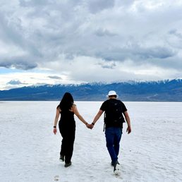
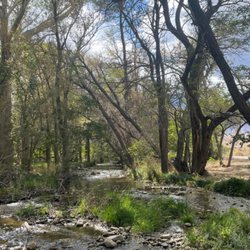
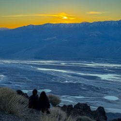
One of the highlights to our trip to Death Valley was Badwater Basin. It was our first time seeing something like this and it was truly a sight. There were a ton of people by the entrance which makes it difficult to take photos without others in the background. So continue to trek forward because the further you go, the less people in your photos! At Badwater Basin, you're 282 feet below sea level! If you turn around and look at the large rock wall opposite the basin, you'll see a small sign indicating the sea level, which is quite an eye-opener. There's also a Badwater Basin sign by the entrance which is also great for photos too. There are no entrance fees and a good number of parking spaces. We didn't run into any issues/diffiiculties in April.


Lowest point in Western Hemisphere. Easy parking. "Toilet" is open pit with an obvious smell so plan ahead. Views were great. It has rained not too many days prior and being in end of winter there was water enough to walk into. BRING water shoes or flip flops. Otherwise your shoes can get caked in salt. Very appealing to us with the -282 sea level.

This review is for Badwater Basin Salt Flats Trail which was a ~1.9 miles round trip that took ~45 minutes to complete. Trail was straightforward, flat and in one direction towards the mountain. However, you could walk as far or in any direction as you like. Stunning views of the salt flats with the distant mountains! Restrooms are available at the parking lot. Short video of the hike for those interested! https://youtu.be/UijIgOv8AZ8

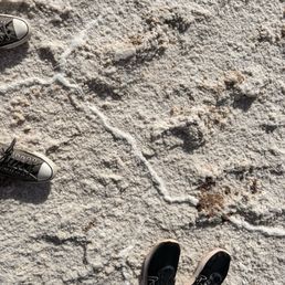
The salt flats span for miles end to end. Marvelous scenery. Fun photo ops. Also stargazing opportunities. We were able to make out Orion's Belt right away. Some people were playing frisbee. Dry, crunchy terrain. Keep your car loaded with drinks and food. Better go near winter, but layer up. Summers in DVNP can exceed 130°F. No shade. Shake off the salt before reentering your vehicle. We walked about 2 mi for about 1 hr.

From Ancient Salt Flats to Temporary Lakes! The first time I visited Badwater Basin was in 2016. I had a few weeks off and was visiting the family in Las Vegas, so I decided to jump into my 2005 Thunderbird and drive to Death Valley National Park. The night before I was to leave, my mother decided to come along! So the next morning off, we went! If I remember correctly, Badwater Basin was our first stop in the park, and its site was stunning! That year, there wasn't any water in that area; it was all white salt as far as the eye could see. We parked the car in the parking lot of Badwater Basin Trailhead and walked all the way to the middle of the flat, well almost. It was a breathtaking experience for both of us. Badwater Basin offers a fascinating glimpse into the geological history of North America. This vast salt flat sits at 282 feet below sea level and is the lowest point in North America. Its unique landscape formed over millions of years through tectonic activity, erosion, and evaporation. The basin was once a part of a massive lake that covered much of Death Valley during the last ice age. As the climate warmed and the lake dried up, layers of salt and minerals were left behind, creating the striking white expanse we see today. This otherworldly landscape serves as a testament to the dynamic forces that have shaped our planet over time. In early 2024, I heard about the temporary lake created by Hurricane Hillary's flooding. My first thought was, "What?! A lake in Death Valley?" I had to see it, but I could not make it there until earlier this month (April). The lake had reduced in size significantly due to evaporation, but it was still a sight to see. In addition to its geological significance, Badwater Basin boasts some intriguing features that add to its attraction. One of the most notable aspects is the hexagonal salt formations on the basin's surface, created by the repeated cycles of flooding and evaporation. These unique patterns create a mesmerizing mosaic that captivates visitors. Another fun fact is that despite its harsh conditions, the basin is home to specialized life adapted to the extreme environment, including salt-tolerant plants and tiny aquatic creatures that thrive in the hypersaline pools. Lastly, the name "Badwater" comes from the undrinkable nature of the water in the basin due to its high salt content, making it a stark reminder of the challenges posed by this unforgiving landscape. Near Badwater Basin, a sign on the side of the Black Mountains indicates sea level. This sign is a striking visual contrast, highlighting the vast elevation difference between the lowest and highest points in the contiguous United States. It's a popular photo spot for visitors, offering a unique perspective on the dramatic landscape of Death Valley National Park. If you are visiting, you should get there either early in the morning or late in the afternoon. The basin's surface can get extremely hot, making it almost impossible for the average visitor to tolerate it for a long time. You should also avoid going on windy days, for obvious reasons.

Badwater Basin is a must-see place when you go to Death valley national park. This place is surreal. Ther salt flats and walk on them is an unique experience on its own. Take the hike inside the flats for a mile and the views are amazing from here. Parking could be challenging at times, restrooms are available too. This place is great, done miss this !!!!

November 3, 2024 Badwater made headlines. After forming in August 2023 due to the aftermath of Hurricane Hilary, the lake did gradually reduced in size but remained throughout the fall and winter seasons. Badwater Basin is the lowest elevation in North America, at 282 below sea level. The basin, normally a saltwater flats that cover 200 miles and is endorheic, The last time the lake filled up before 2023 and 2024 was in 2005. They have pit toilets brace yourself lines get long. There is a parking lot so put into consideration there may be a wait till you may park. My 76 year young mother in law enjoyed the salt water flats, even with her walker. we met many European tourist on our road trip everyone was so cheerful. I'd like to say this was a last minute trip, make sure to download gps routes as there is no internet, make sure to take extra gas just in case you go down the wrong road never know. We were prepared for the drive. Sametime we were not to educated on what to see if spending the day. Our time there seemed to go quickly, with no internet no check ins for yelp but only photos. There was no fees to enter Death Valley National Park, nor any type of Rangers. We had many ququestions. We did go on a Sunday maybe that's why.

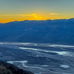
Death Valley is a spectacular and large national park. It boasts several neat places and unique landscapes like badwater basin. 282 feet below sea level and unique salt formations The recent rains have made an epic mini lake leading to some fantastic reflection shots of sunrises and sunsets. If you stop at badwater basin, you are not far from artists palette and zabriskie point, both are also good spots to visit.

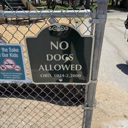
An easy daytrip from Las Vegas, Badwater Basin is the lowest point in North America and it's normally a dry, barren salt flat. But because of Hurricane Hilary in 2023, a temporary lake called Lake Manly formed and has become an internet sensation. At one point, the lake was deep enough that the park allowed visitors to kayak and paddleboard! When we visited, there was still enough water to walk out to but beware...the mud literally sucked our water shoes off our feet and we ended up getting a lot of scratches from the salt crystals. We got some pretty amazing pictures with the reflective water surface but I wouldn't go out there again. We were a muddy mess and my feet were super tender afterwards. Bring paper towels and extra water to wash your feet after! If you're here to grab a picture, I would recommend going during sunset. If you're lucky, the sky will have vibrant hues of pink, orange, and yellow. And when the water is still, there will be a perfect reflection of the sky. And when we went, the mountains in the background still had snow too! There's going to be a lot of people with the same idea and parking gets really full. We got lucky and pulled into a spot along the road and just walked out to the lake. Overall, a great and potentially a once-in-a-lifetime experience! But if the water does come back, I'm not walking out there for the gram. Also, reminder that dogs aren't allowed out here. We saw a lot of people get yelled at by park rangers.

This was definitely a nice stop to break up our drive. It was amazing seeing it filled with water at the time we went in February 2024. We decided to go out into the water with our shoes off and we are glad we did. The salt water on our skin felt very interesting. Especially when we were trying to dry it off.

Highly unique place- how often do you get to walk across salt flats 200+ feet below sea level?? Sunset was epic here, it was crowded but there's room to spread out. I'd recommend bringing an extra pair of shoes (something like keens would be ideal) and a towel, since you'll want to walk deeper into the water (when it exists and isn't dried up!) The salt kind of resembles snow, which was fascinating in December. It was in the 60s when we visited, very comfortable.
Three days before we were standing up at Dante's Point and you could see the teeny tiny specks of people wandering around Badwater Basin and that's when I told the lovely Mrs we are heading back thru the lower passage to see this in person! And we did, and it was worth it! One of those, I've never seen anything like it moments. It's just amazing to the naked eye, cameras simply don't do this justice. We wandered around for almost 2hrs but that time just flew by. Met lots of nice people. It's mentioned in one of the tips(ps tips are going away soon) to bring sunglasses and they were kidding. Without my sunglasses, it would have been painful to the eyes. The bathrooms are kind of awful. Before you head to Death Valley, download the maps as no cellular and make sure you aren't running low on fuel/electric. I'd actually go here again if we ever find ourselves in the area. 2.5hrs from Las Vegas. Worth it.

3 months ago
The farthest point I think in the park and we got to see it with a little water which created this incredible reflection. Good amount of parking and you can walk as far as you'd like on the basin. Peep the sea level sign on top of the mountain to really grasp how 'low' you are! read more


We decided to take a little day trip out to Death Valley to view the wildflower bloom, hike a bit and visit Lake Manly (otherwise known as Badwater Basin). I really wanted to walk in the glorious saltwater. We were there on a Thursday and this place was hopping with people. I had forgot that spring breaks have begun. We eventually found a place to park and made our way out to the water via the boardwalk that heads out. We all know that Badwater Basin is the lowest point in the USA. It is 282 feet below sea level and it sure was pretty. The basin normally does not have water, but with all the rain California received this winter the water was almost up to my shins. The saltwater flats cover over 200 miles. The basin includes sodium chloride, gypsum, borax, and calcite. The best part of the visit was that by the time I stepped out of all that saltwater, my feet were so soft. It was truly a natural exfoliation for the feet. Be respectful and leave your pets at home as they are only allowed on designated dirt roads. Most of all LEAVE NO TRACE and Happy Adventuring. read more


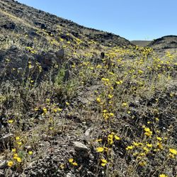
Badwater basin is a site to be seen whether it is dry or when it is wet (which is rare but happening spring 2026). You can park and walk out on to the salt flats to really explore it. Bring your sunglasses, as the bright white sand is blinding! Be sure to wear sunscreen too, as you can burn super fast out there. I highly recommend driving south until the salt flats end. It's a beautiful drive especially with the current wildflowers. read more


One of the highlights to our trip to Death Valley was Badwater Basin. It was our first time seeing something like this and it was truly a sight. There were a ton of people by the entrance which makes it difficult to take photos without others in the background. So continue to trek forward because the further you go, the less people in your photos! At Badwater Basin, you're 282 feet below sea level! If you turn around and look at the large rock wall opposite the basin, you'll see a small sign indicating the sea level, which is quite an eye-opener. There's also a Badwater Basin sign by the entrance which is also great for photos too. There are no entrance fees and a good number of parking spaces. We didn't run into any issues/diffiiculties in April. read more

5 months ago
It was really cool getting to see this spot after the rain. Me and my buddy thought it was gonna be walk AF but it was actually really dope. It's hot AF tho so bring your water bro. Or just whatever you like to stay hydrated with. They should sell coconuts. read more

5 months ago
Lowest point in Western Hemisphere. Easy parking. "Toilet" is open pit with an obvious smell so plan ahead. Views were great. It has rained not too many days prior and being in end of winter there was water enough to walk into. BRING water shoes or flip flops. Otherwise your shoes can get caked in salt. Very appealing to us with the -282 sea level. read more


This review is for Badwater Basin Salt Flats Trail which was a ~1.9 miles round trip that took ~45 minutes to complete. Trail was straightforward, flat and in one direction towards the mountain. However, you could walk as far or in any direction as you like. Stunning views of the salt flats with the distant mountains! Restrooms are available at the parking lot. Short video of the hike for those interested! https://youtu.be/UijIgOv8AZ8 read more


The salt flats span for miles end to end. Marvelous scenery. Fun photo ops. Also stargazing opportunities. We were able to make out Orion's Belt right away. Some people were playing frisbee. Dry, crunchy terrain. Keep your car loaded with drinks and food. Better go near winter, but layer up. Summers in DVNP can exceed 130°F. No shade. Shake off the salt before reentering your vehicle. We walked about 2 mi for about 1 hr. read more


From Ancient Salt Flats to Temporary Lakes! The first time I visited Badwater Basin was in 2016. I had a few weeks off and was visiting the family in Las Vegas, so I decided to jump into my 2005 Thunderbird and drive to Death Valley National Park. The night before I was to leave, my mother decided to come along! So the next morning off, we went! If I remember correctly, Badwater Basin was our first stop in the park, and its site was stunning! That year, there wasn't any water in that area; it was all white salt as far as the eye could see. We parked the car in the parking lot of Badwater Basin Trailhead and walked all the way to the middle of the flat, well almost. It was a breathtaking experience for both of us. Badwater Basin offers a fascinating glimpse into the geological history of North America. This vast salt flat sits at 282 feet below sea level and is the lowest point in North America. Its unique landscape formed over millions of years through tectonic activity, erosion, and evaporation. The basin was once a part of a massive lake that covered much of Death Valley during the last ice age. As the climate warmed and the lake dried up, layers of salt and minerals were left behind, creating the striking white expanse we see today. This otherworldly landscape serves as a testament to the dynamic forces that have shaped our planet over time. In early 2024, I heard about the temporary lake created by Hurricane Hillary's flooding. My first thought was, "What?! A lake in Death Valley?" I had to see it, but I could not make it there until earlier this month (April). The lake had reduced in size significantly due to evaporation, but it was still a sight to see. In addition to its geological significance, Badwater Basin boasts some intriguing features that add to its attraction. One of the most notable aspects is the hexagonal salt formations on the basin's surface, created by the repeated cycles of flooding and evaporation. These unique patterns create a mesmerizing mosaic that captivates visitors. Another fun fact is that despite its harsh conditions, the basin is home to specialized life adapted to the extreme environment, including salt-tolerant plants and tiny aquatic creatures that thrive in the hypersaline pools. Lastly, the name "Badwater" comes from the undrinkable nature of the water in the basin due to its high salt content, making it a stark reminder of the challenges posed by this unforgiving landscape. Near Badwater Basin, a sign on the side of the Black Mountains indicates sea level. This sign is a striking visual contrast, highlighting the vast elevation difference between the lowest and highest points in the contiguous United States. It's a popular photo spot for visitors, offering a unique perspective on the dramatic landscape of Death Valley National Park. If you are visiting, you should get there either early in the morning or late in the afternoon. The basin's surface can get extremely hot, making it almost impossible for the average visitor to tolerate it for a long time. You should also avoid going on windy days, for obvious reasons. read more


Badwater Basin is a must-see place when you go to Death valley national park. This place is surreal. Ther salt flats and walk on them is an unique experience on its own. Take the hike inside the flats for a mile and the views are amazing from here. Parking could be challenging at times, restrooms are available too. This place is great, done miss this !!!! read more


2 years ago
November 3, 2024 Badwater made headlines. After forming in August 2023 due to the aftermath of Hurricane Hilary, the lake did gradually reduced in size but remained throughout the fall and winter seasons. Badwater Basin is the lowest elevation in North America, at 282 below sea level. The basin, normally a saltwater flats that cover 200 miles and is endorheic, The last time the lake filled up before 2023 and 2024 was in 2005. They have pit toilets brace yourself lines get long. There is a parking lot so put into consideration there may be a wait till you may park. My 76 year young mother in law enjoyed the salt water flats, even with her walker. we met many European tourist on our road trip everyone was so cheerful. I'd like to say this was a last minute trip, make sure to download gps routes as there is no internet, make sure to take extra gas just in case you go down the wrong road never know. We were prepared for the drive. Sametime we were not to educated on what to see if spending the day. Our time there seemed to go quickly, with no internet no check ins for yelp but only photos. There was no fees to enter Death Valley National Park, nor any type of Rangers. We had many ququestions. We did go on a Sunday maybe that's why. read more


Death Valley is a spectacular and large national park. It boasts several neat places and unique landscapes like badwater basin. 282 feet below sea level and unique salt formations The recent rains have made an epic mini lake leading to some fantastic reflection shots of sunrises and sunsets. If you stop at badwater basin, you are not far from artists palette and zabriskie point, both are also good spots to visit. read more


An easy daytrip from Las Vegas, Badwater Basin is the lowest point in North America and it's normally a dry, barren salt flat. But because of Hurricane Hilary in 2023, a temporary lake called Lake Manly formed and has become an internet sensation. At one point, the lake was deep enough that the park allowed visitors to kayak and paddleboard! When we visited, there was still enough water to walk out to but beware...the mud literally sucked our water shoes off our feet and we ended up getting a lot of scratches from the salt crystals. We got some pretty amazing pictures with the reflective water surface but I wouldn't go out there again. We were a muddy mess and my feet were super tender afterwards. Bring paper towels and extra water to wash your feet after! If you're here to grab a picture, I would recommend going during sunset. If you're lucky, the sky will have vibrant hues of pink, orange, and yellow. And when the water is still, there will be a perfect reflection of the sky. And when we went, the mountains in the background still had snow too! There's going to be a lot of people with the same idea and parking gets really full. We got lucky and pulled into a spot along the road and just walked out to the lake. Overall, a great and potentially a once-in-a-lifetime experience! But if the water does come back, I'm not walking out there for the gram. Also, reminder that dogs aren't allowed out here. We saw a lot of people get yelled at by park rangers. read more


2 years ago
6 months ago
This was definitely a nice stop to break up our drive. It was amazing seeing it filled with water at the time we went in February 2024. We decided to go out into the water with our shoes off and we are glad we did. The salt water on our skin felt very interesting. Especially when we were trying to dry it off. read more


Highly unique place- how often do you get to walk across salt flats 200+ feet below sea level?? Sunset was epic here, it was crowded but there's room to spread out. I'd recommend bringing an extra pair of shoes (something like keens would be ideal) and a towel, since you'll want to walk deeper into the water (when it exists and isn't dried up!) The salt kind of resembles snow, which was fascinating in December. It was in the 60s when we visited, very comfortable. read more


Three days before we were standing up at Dante's Point and you could see the teeny tiny specks of people wandering around Badwater Basin and that's when I told the lovely Mrs we are heading back thru the lower passage to see this in person! And we did, and it was worth it! One of those, I've never seen anything like it moments. It's just amazing to the naked eye, cameras simply don't do this justice. We wandered around for almost 2hrs but that time just flew by. Met lots of nice people. It's mentioned in one of the tips(ps tips are going away soon) to bring sunglasses and they were kidding. Without my sunglasses, it would have been painful to the eyes. The bathrooms are kind of awful. Before you head to Death Valley, download the maps as no cellular and make sure you aren't running low on fuel/electric. I'd actually go here again if we ever find ourselves in the area. 2.5hrs from Las Vegas. Worth it. read more


One of my favorite stops in Death Valley NP. The lowest place in North America at 282 feet below sea level, there is a huge expanse of salt flats to see. It was my first time seeing salt flats, and they were impressive. If you were just looking from a distance, they can be mistaken for snow. This is a good first stop of the day before it gets too hot with the sun overhead. Highly recommend. read more

2 years ago
The lowest place on the continent is also one of the most amazing! There's a large parking lot and vault toilet here for your convenience. A small staircase will take you down to the natural spring that gave this basin its name. You can walk as far out into the basin as you'd like, but prepare for very windy and hot conditions. The further you go the more impressive the landscape, but also it might be wet because water doesn't drain here. Your shoes WILL be extremely salt crusted after walking through the basin but the salt will wash off with a simple rinse read more


Unfortunately the week we visited has rain a week ago. That is the reason we did not see the larger salt Crystal. It got washed out a bit. Badwater is the actual Death Valley. You need to walk some distance to see the beautiful site. The crack area will be a miles and half walk. The crack octagons is beautiful. If you paid attention to where you walk, there is salt Crystal on the floor. This Crystal is bigger when there is no rain for a while. The basin is big. It depends how you want to explore. The deeper into the trail, the beauty of the Crystal is more. read more


Popular stop when visiting Death Valley. For such a crowded place the parking lot seemed a little small expecially on weekends / high season. You'll eventually get a space so don't worry. The experience is cool and to maximize your stay you'll likely want to walk deep into the salt field. There isn't much else to do here. - Note that one of the roads to the Badlands Basin is closed because of major damage from flash flooding. Check road status before you actually arive to Death Valley. You can only enter Badwater Basin from furnace creek as of late 22 / early 23. - I enjoyed the Devil's Golf Course more because it was less crowded. All cars can drive on that dirt road. read more


2 years ago
One of the most unique experiences in the life - stepping on the salty lands at the lowest point in North America. read more


3 years ago
I love going on adventures and checking out Badwater Basin was one of those adventures that I found it interesting and a must visit. This place is located in Death Valley. I went here back in March 2022 with my favorite group of people. The weather was around mid 70-80s and was slightly windy. By noon it was getting quite hot so please protect yourself from the scorching heat and hydrate. We were heading from Vegas so the drive was about 2+ hours so it really depends on your location. What to Bring - sunscreen, lots of water, a hat, comfortable shoes, sunglasses, food, and snacks. Fees - There was no fee to enter and access this place. No online reservation required either. There were plenty of free parking. You can walk further out to view the salt flats. We did not walk further out because it was getting way too windy and too hot by noon. Don't worry you will still get a great view of the salt near the entrance walk way. Restrooms - FYI, the restrooms here are horrendous and it is worse than the public beach restrooms. That's right, it's like your worst stinky ass horrific nightmare. Try to use the restrooms BEFORE arriving here or don't even use it if you don't need to. There are NO WATER here (I repeat NOO WATER), so bring extra water bottles to wash your hands. Use it at your own risk people! If you have the chance to visit this place come check out Badwater at least once despite the horrific restroom. You will learn about how vast this place is and where you are at, you're actually standing 282 feet below sea level. Pretty interesting fact right? Take plenty of photos and look for that white sign on the mountains. After that head over to Zabriskie's Point for your next adventure. read more


The lowest point in the Western Hemisphere! Surprisingly, there is some life here with some vegetation, salt flats, and some pupfish. Definitely an iconic landmark that is worth checking out if you happen to make it out here. Best month is probably in October when the sun isn't as intense, yet still warm enough to camp and hike without needing a coat. There is a pretty large parking lot that you pull off from the road. You can make your way onto the salt flats and explore a little. Overall, I enjoyed know it was the lowest point. After all, I do have friends in low places. read more


Badwater Basin is the lowest point in the country. How low can you go?! Well, Badwater is approximately 282 feet below sea level. Yep. That's pretty damn low if you ask me. It's crazy to think that there was actually water here at some point. A lake that evaporated thousands of years ago. All that's left now are the salt flats that span over 200 plus miles. But wow! These salt flats are just striking to see. You're literally walking on salt! It's amazing. There's also a tiny little pool of water near the entrance to the landmark. While I found Badwater Basin to be stunning, this would typically be a spot that I would avoid because there was just too many other people here for me. I would definitely get here at the crack of dawn to be able to experience this without the crowds of other people. Other than that, it's definitely a must see. Plus, you'll earn those bragging rights by being one of the people who have been to one of the lowest points on earth. How about them apples? read more


Badwater Basin is a must see spot in Death Valley National Park. Why? Because it's below sea level, is the lowest point in the western hemisphere, 282 ft (85m). Look up across and you'll sign the sign Sea Level on the rocks and it's pretty shocking to see how high up it is. Badwater Basin is a huge salt flat that you can walk to. The place is wide and as you walk it you realize how vast it is! There's a small pool of water which surprisingly hosts life at the entrance with signs around it. As usual with Death Valley, this is another unique spot, out of this world, the salt looks like a white blanket of snow in the middle of the desert. The place is easy to find, passed Furnace Creek Visitor Center, there are signs, a parking lot and anyone can walk it. It was the most populated spot within the park and the restrooms proved that! You can walk around as much or little as you want. The views are spectacular especially if you go across and hike up a tad. It's worth it! A must see in Death Valley! read more


Lowest point in North America: Death Valley National Park We were here the first time in April 2014. It was already warm then. Last weekend, February 2021, we revisited the salt flats, the weather was much more comfortable in the low 70°s and we were able to walk farther in distance down the basin. Temps can reach up to 120°F in the summer! Bring plenty of water when visiting Badwater. There is a sign at the front marking the low point at 282-feet below sea level. I couldn't even fathom that number but if you look up at the mountain ahead there is a sign that said SEA LEVEL and I am assuming that the sign was at 282 feet and we are below... waaaay below. It was my first time seeing it... it was pretty cool just thinking how deep we were at one point in the ocean. You can see the salt flat from your car but a short walk would take you onto the salt flats. The first 200-feet of the trail surface is paved with asphalt and wood. There are interpretive signs to read and get educated, one of the sign read "Sodium Chloride-- better known as table salt-- makes up the majority of salt on Badwater Basin." This is also where the sea level sign marker is placed and many people like to take photos in front of it (yes, including us). After getting past that you'll be walking on all natural salt. It's a surreal landscape of vast salt flats covering nearly 200 square miles across the park. Badwater Basin is one of the most visited places in Death Valley National Park and, you guessed it, finding parking can be challenging. It is one of the locations on the "do-not-miss" list for a visit at the park. Taking a walk on the salt flats was a pretty neat experience. From Furnace Creek it is 17 miles south on Badwater Road. Don't forget to hydrate... Review #2124 read more


2 years ago
This place has always been amazing and a must see if you come to Death Valley. However this time was unique and the most incredible experience. Bad water. 282 ft below sea level, a level which is really brought into perspective when you look up on the massive outcropping at the sea level marking. Pretty amazing. What made this absolutely breathtaking is that what is normally a 200 square mile salt flat had become the most beautiful lake. Light blue, crystal clear water on the lake bed of pure salt, shining through the water like diamonds. Actually it's salt, gypsum, borax and others, but I digress. It's was peaceful and exciting at the same time. I felt obligated to take my shoes off and walk far into the "lake" which stayed at about 4"deep. With the Panamint Mountains in the background this was a very spiritual experience. This is a very popular location in DV which fills up quick. Earlier the better, weekdays if possibly. Either way, a highlight of the trip. read more


2 years ago
What is an amazing about this place. First of all it's the lowest point in the continental United States. With the lowest point in the world being the dead sea in Israel. It doesn't matter, sunset or sunrise this place is incredible. And if you sit silently, you can hear the salt crystals pop. The geometric shapes are mesmerizing, and depending on the time of day or night that you go, the lighting can be perfect for photographic purposes. Once upon a time, this used to be a dry lake bed. With an abundance of salt, as the water evaporated it left behind an incredibly unique pattern on a dry flat lake bed. When I first started frequenting this area, you didn't have to walk very far out onto the salt flats to experience the geometric shapes. However now due to the popularity, you have to walk at least a half a mile if not more out onto the salt flats almost to the other side to be able to observe the peaceful perfect quiet shapes. It is worth it. Just don't go during the summer. I did and took 1 gallon of water with me across the lake bed. By the time I returned it was completely consumed. The heat although a dry heat, it's like opening the oven door and stepping inside at 400°. read more


4 years ago
One of the most unique and coolest places I've ever seen! Truly incredible to be 200 feet under sea level! read more


Lowest point in North America...does it really need an introduction? Coming here in August means you're likely going to be the only person in Badwater. It's GREAT for pics, but only if you're crazy enough to see how hot Death Valley is. To be frank, when the back of your eyeballs start feeling hot, it's just...something else. Hell is the closest term for it. Dunno if you can survive outside for more than 15 minutes. Hell, trying to even take a video isn't possible with modern phones- your phone will overheat trying to record a video even with an umbrella. It's just that hot. Hydrate generously: when the weather gets 115+ F (46C), you'll always want to carry water with you. read more


5 years ago
Mood- Inspired by May A You know I have lived in Nevada for quite some time, and am still finding out new things to catch my curious nature. This particular adventure was inspired by fellow Yelper May. I saw her photos and was immediately intrigued. Upon entering Death Valley there was a self serve kiosk to pay for your entrance. We paid the $30.00 and pulled out our phones to navigate us to this famous spot where everyone takes their photos. Upon arrival I didnt automatically see the dock type area as the parking was so intense we had to drive down a ways, and hike down the rock area to the salt areas below. Once we arrived at the famous spot where all the photos are taken the thought of true insignificance took over. What a wonder to be surrounded by something of such magnitude, while we are just the size of normal humans to walk these grounds. It was breathtaking. You dont realize how enormous something is until you are engulfed in it. Badwater Basin is the lowest point in America. It is exactly 282 ft below sea level. As you are walking, there is a small marker up in the mountains facing east that shows where sea level is at. This Basin is named Badwater due to a mule that refused to drink the water as it was just to salty. This particular pool is home to a snail that is only found here. There was a lake that was on these grounds many thousands of years ago. When the lake evaporated the salt deposits were left behind. You can find the geometric salt polygons as water rises up and evaporates. To get to these it is a short easy trek from the dock, almost 1.5 miles roundtrip. The salt flats are about 200 square miles. The flats are comprised of calcite, gypsum, borax, and sodium chloride. The air is amazing to breathe in. Would most def recommend - the pricing is fair for the beauty you are about to see and enjoy. However be smart. In the summer our weather is HOT - so I would not advise being adventurous after 11 am in the summer. Def bring water and stay hydrated. Heat stroke is not a good time. JS Location is Death Valley National Park south of Furnace Creek - parking is ample. However not with the parking lots, there is lots of parking on the streets. Please be careful as they are just 2 lanes. read more


6 years ago
It's unique geology makes Badwater Basin an irresistible attraction. It is an endoreic basin, water accumulates in Death Valley and has no way to run off leaving it's salt content behind. Salt from the surrounding mountains accumulates on the basin floor washed down to the valley in rain and melting snow, as well. During the Quaternary Period a lake 86 miles long and 600' deep, called lake Manly existed in this area which eventually evaporated and left it's salts. Today the salt depth varies from 3 to 60 inches and sits on top of a mud base. Death Valley is the lowest point in North America at 282' below sea level. The lowest point in the Western Hemisphere is in Laquna del Carbon, Argentina at 344' below sea level. Death Valley covers an area of over 200 square miles. Roughly 7.5 X 5 miles, the valley is covered mainly by sodium chloride (salt) with some calcite, gypsum and borax. Don't try to drive your vehicle over the salt flats which are a thin layer of salt on top of mud. The best time to visit Badwater Basin is between October and March. There is a pool at the basin but do not drink the water it is (undrinkable). Pickleweed, aquatic insects and the Badwater snail can be found in the water. There is a sign 282 feet above the pool which marks sea level, A boardwalk takes you out and into the salt flats. The salt is electrostatic and is difficult to get off your shoes and clothing. Interpretive signage is at different points near the pool which is fed by an underground spring. Surprisingly Death Valley has one of the largest aquifers in the continental United States. Vehicle fee to enter Death Valley National Park is $20 for 7 days. There is a visitors center which has a full display of information about the park located at Furnace Creek.. The roads through the park are well paved with places of interest clearly marked to stop and get out to observe. A map is available which clearly show the places of interest and other valuable information. Keep your vehicle on the paved roads because you might get stuck in loose sand. read more


2 years ago
very impressive place! salt lake, we got there when there was still water there. white salt field against the backdrop of high mountains. looks amazing. There is parking, restroom. read more


3 years ago
It was amazing to see salt flats in the desert, 282 ft below sea level. It was a nice walk on a beautiful day in January. The weather was perfect. read more


Page 1 of 3
More info about Badwater Basin
Highway 190
Death Valley, CA 92328
Directions
Hours
Outdoor Amenities
Badwater Basin Reviews in Other Languages
Ask the Community - Badwater Basin
Hello, does anyone know if this is this open right now to visit?
Review Highlights - Badwater Basin


Badwater Basin - landmarks - Updated July 2026
Best of Death Valley
People found Badwater Basin by searching for…
Things to Do in Death Valley, CA
Campgrounds in Death Valley, CA
Visitor Centers in Death Valley, CA
Natural Hot Springs in Death Valley, CA
Star Gazing in Death Valley, CA
Attractions in Death Valley, CA
Scenic View in Death Valley, CA
Fishing Spots in Death Valley, CA
Off Road Trails in Death Valley, CA
Watch Sunset in Death Valley, CA
Arts & Entertainment in Death Valley, CA
National Parks in Death Valley, CA
State Parks in Death Valley, CA
Camping Cabins in Death Valley, CA
Photo Spots in Death Valley, CA
Hiking Trails in Death Valley, CA
Night Hike in Death Valley, CA
Fun Date Night Ideas in Death Valley, CA