Devil's Golf Course Photos


You might also consider
More like Devil's Golf Course
Recommended Reviews - Devil's Golf Course
Start your review...

Reviews With Photos

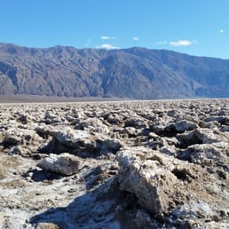
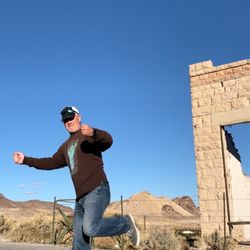
Epic views of miles and miles of crystallized salt formations with the gorgeous Panamint Valley as your backdrop! I know that everyone glorifies Badwater Basin, and while it's certainly a beautiful sight, I found the views and overall experience here to be far more thrilling. It's a short drive from Badwater Road, but the kicker here is the rough, unpaved road that you must drive down to get here. It makes total sense as to why more people don't come here. They're scared of the drive. But honestly, it's not that bad. Definitely isn't as bad as the drive up Natural Bridge (wouldn't do that drive again). If you don't have a 4 wheel drive and your tires are in good condition, just drive really slow down the bumpy road. Once you make it to the end, you'll be met with the most stunning views of the saltpans. It literally felt like I was about to film a movie. Everywhere you turn, it's like BAM! Gorgeous valley views. These salt formations are something else. I get why they named it Devil's Golf Course. I mean... could you imagine the Devil trying to play golf here? I mean seriously... all of those beautiful jagged edges. Yikes! But damn is it stunning. You're looking at billions of salt crystals that have been eroded by years and years of wind and rain. Oh yeah, and for you social media junkies; TONS of photo ops here. Endless photo ops! Just be careful when walking through the terrain because the rocks are extremely jagged. This was one of my favorite stops within Death Valley National Park. If your car can handle the rough but short drive, I'd say DO IT like Nike.

Devil's Golf Course was one of my favorite stops during our Dec 2021 visit to Death Valley. Visiting during winter is the "high season" for Death Valley due to the much milder temperatures, and we spent a few hours earlier checking out the Badwater Basin, which had a lot of people walking up and down the trail. In comparison, close to sunset, the Devil's Golf Course was pretty deserted! We headed here after driving the Artist's Drive nearby. It was easy to find (imagine driving on a single winding road, and then coming up is a simple brown sign pointing you the way to DEVILS GOLF COURSE; this was the case for all of the sights in the park) and we turned to a gravel-ish road and drove carefully down to a small parking area where we were surrounded with salt formations. Since it was late in the day for daylight it was only us and two other vehicles ahead of us - as the sun grew dim the surroundings almost looked eerily, otherworldly blue against the sea of formations. The salt formations here were more impressive than the ones at Badwater Basin, larger and craggier, and whiter too without people walking around them. The nearby signs had additional photos of what the delicate salt formations can look like without disturbance from visitors. Wonderful!

Do you want to die in sweltering heat standing on painfully sharp rocks? Devil's Golf Course is for you. Badwater was neat, but this place embodies what Death Valley is about. Sunscreen and a hat is basically mandatory, as there's no shade and no plants. The unpaved road was something I did not want to get a blown tire in either, hence drive carefully and take your time. You'll see that the "golf course" radiates far out from the road, and personally I wouldn't hike it for long as falling on the rocks will seriously hurt. Great for photos though! Try not to die in this hellish landscape, and you'll get some breathtaking desolate landscape shots.

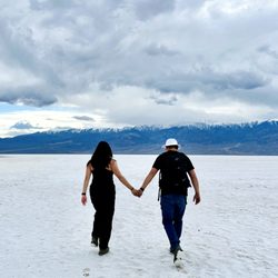
Really unique and pretty place. The pictures don't do it justice. I am really glad I trekked out to see it even though the road was closed when I visited in February 2024. People just hiked on the dirt road, which took around 20-30 minutes each way. The views along the hike were nice and I liked seeing the sand turn into salt.

I went on a hike with a group and stopped by here today and it was fascinating and surreal. This area was once covered by a lake, the water evaporated some 2,000 years ago, leaving behind a 1,000 foot-layer of mineral and salts. The Devils Golf Course got its name from a guidebook back in the 30's that stated: "Only the devil could play golf on such a surface." This is accessible via a half mile dirt road that you can drive with no problem. It is on the main road in the park between Badwater and Furnace Creek. There are signs posted that direct you there. Once you are there, you will notice you are in a sea of jagged salt pieces. It was fun taking pictures there. The ground is so full of spikes. A must see!!


If you happen to pass by the neighborhood of Death Valley, make sure you drop by the Devil's Golf Course. Not too far from the Badwater basin, it's truly an extraterrestrial sight to behold. Your car can park all the way to the parking lot in the middle of this barren area, where it looks an atomic bomb has been spit out on it during the creation. Only a few caveats when visiting this must-see spot in Death Valley: 1) The rocks are hard and have sharp edges, so watch your steps and don't fall. 2) The small road from the main road to the parking lot is a 1/4 to 1/2 mile drive on dust bowl road with uneven surface with large potholes, so watch out and drive slowly. 3) Have enough fuel, drink, and don't get stranded in Hades. Truly a marvelous, unforgettable natural wonder of our planet.

Really cool spot to stop by at. If you have a low car I definitely do not recommend you driving into here! The drive way is dirt and very rocky. I was literally driving 9mph at one point. It was interesting to look at the salt crystals and take some cool photos. Just be careful where you step if you decide to venture out. The salt crystals formed into a hard point and it will definitely hurt if you fall on it.

Much like Badwater Basin itself, Devil's Golf Course is a very hot but interesting place geared for tourists. It is a little further off of Badwater Road, but worth the short drive. I find this a lot more interesting than Badwater Basin itself. Here the salt crystals start to take shape and form little mini sculptures. It's just a very hot place (it was 120f when I was there) and you need sunscreen, water, as there is no shade.

This was one of our favorite stops during our Death Valley NP visit during the winter of 2017. This is one of those spots that you have to see to believe...and the description is apt. Massive fields of crusty salt crystals formed at the base of a dry lake...so cool! We took the long graded access road into the "golf course" where there are a few interpretive panels and plenty of spaces to park. This is passenger car friendly, although we had our 4WD truck so no problems there. The temps and wind were mild here on our visit, but as always, check the weather when you have service so no nasty surprised. Or just look up, plenty of sky views to give you a clue...lol. We took lots of pictures here and spent an easy hour walking out into the crusty fields of geologic/wind/water eroded salt. Definitely wear closed toed shoes here, as the ground has the option to reach out and bite exposed skin. Be careful with foot placement when walking the course, as it would be easy to lose footing and incur a nasty spill. Mark this as a must see if you choose to visit Death Valley, as the Devil's Golf Course won't disappoint.

Quite simply one of the most amazing things we have ever seen. These salt boulders of the Devil's Golf Course stretch for what seems like forever. The salt boulders have weathered into unique jagged formations that are nevertheless beautiful and eerie at the same time. Be careful if you explore into the salt field -- the boulders are sharp and some are hollow. We found some small pieces of salt loose and tasted it -- so much saltier than regular table salt, and with a deeper flavor too. The crystal formations are always shattering and cracking, and when they do it sounds like metal objects clinking. Fascinating stuff!!

Don't forget your sand wedge for sure. This bizarre landscape in the midst of Death Valley is somewhat unbelievable until you get out of the car and get up close. A long hike isn't suggested due to the challenging landscape, but getting out to explore a bit is definitely a good idea. The ground feels like a mix of swiss cheese solidified and something from the moon. Definitely a unique experience in Death Valley.

I can't even imagine what the first explorers trying to cross these salt formations must have thought. These salt formations are razor sharp crystals that spread across the flats as far as you can see. On these expansive flats, it's easy to find a spot to pull over and enjoy them without anyone else nearby. On a hot day you can hear the crystals pop as they shatter in the heat. A unique experience you won't find other places.
2 months ago
Gives you the other worldly vibes. To get to the Devils Golf Course, you have to drive on a gravel road which can get bumpy and dusty. Once you arrive it's a lookout than an hike but looks pretty cool! read more


One of my favorite stopoffs in Death Valley. Ninety percent of park visitors drive right past the dirt road that takes you to the Devil's Golf Course. Big mistake. The dirt road can be traversed by a prius. What I like most about the Devil's Golf Course is that this place is less crowded, expecially when compared to Badwater Basin which feels like tourists trap because of all the people. - It's OK to taste the salt from your finger tip. - I strongly recommend that you walk deep into this salt experience. It's like walking on snow and ice. Just know that the rocks here can be sharp. read more


What is The Devil's Golf Course??? Interesting name, right??? We just had to take a look when our friend, Niki, suggested it. She had been here before and was our tour guide. I had no idea that this phenomenon existed! Niki pointed me in the right direction. I just drove about 15 miles per hour as she advised because of the large rocks on the unpaved road. She pointed out a few cars in the distance that were parked on the edge of the "golf course", so, we kept going until we reached the informational sign and the other cars. It turns out that this area used to be a lake. It dried up and left behind a gigantic field of salt crystals. It was amazing and vast. It looked like the surface of another planet or some other world. A tourist asked us why it's named The Devil's Golf Course... Well... If you golf, you wouldn't want to play here ... Haha! It is jagged sharp! We didn't even want to touch it or walk on it! I read Sarah C.'s review which stated that a guidebook from the 1930's stated that "Only the Devil could play golf on such a surface". Ahhh... That's how this place was named! It was hot, so we didn't stay long. We just took a few photos, admired the artwork of Mother Nature and went onto the next cool site at Death Valley National Park! Thanks to Niki for sharing this fabulous place with Marlina and me! read more


Epic views of miles and miles of crystallized salt formations with the gorgeous Panamint Valley as your backdrop! I know that everyone glorifies Badwater Basin, and while it's certainly a beautiful sight, I found the views and overall experience here to be far more thrilling. It's a short drive from Badwater Road, but the kicker here is the rough, unpaved road that you must drive down to get here. It makes total sense as to why more people don't come here. They're scared of the drive. But honestly, it's not that bad. Definitely isn't as bad as the drive up Natural Bridge (wouldn't do that drive again). If you don't have a 4 wheel drive and your tires are in good condition, just drive really slow down the bumpy road. Once you make it to the end, you'll be met with the most stunning views of the saltpans. It literally felt like I was about to film a movie. Everywhere you turn, it's like BAM! Gorgeous valley views. These salt formations are something else. I get why they named it Devil's Golf Course. I mean... could you imagine the Devil trying to play golf here? I mean seriously... all of those beautiful jagged edges. Yikes! But damn is it stunning. You're looking at billions of salt crystals that have been eroded by years and years of wind and rain. Oh yeah, and for you social media junkies; TONS of photo ops here. Endless photo ops! Just be careful when walking through the terrain because the rocks are extremely jagged. This was one of my favorite stops within Death Valley National Park. If your car can handle the rough but short drive, I'd say DO IT like Nike. read more


Devil's Golf Course was one of my favorite stops during our Dec 2021 visit to Death Valley. Visiting during winter is the "high season" for Death Valley due to the much milder temperatures, and we spent a few hours earlier checking out the Badwater Basin, which had a lot of people walking up and down the trail. In comparison, close to sunset, the Devil's Golf Course was pretty deserted! We headed here after driving the Artist's Drive nearby. It was easy to find (imagine driving on a single winding road, and then coming up is a simple brown sign pointing you the way to DEVILS GOLF COURSE; this was the case for all of the sights in the park) and we turned to a gravel-ish road and drove carefully down to a small parking area where we were surrounded with salt formations. Since it was late in the day for daylight it was only us and two other vehicles ahead of us - as the sun grew dim the surroundings almost looked eerily, otherworldly blue against the sea of formations. The salt formations here were more impressive than the ones at Badwater Basin, larger and craggier, and whiter too without people walking around them. The nearby signs had additional photos of what the delicate salt formations can look like without disturbance from visitors. Wonderful! read more

Do you want to die in sweltering heat standing on painfully sharp rocks? Devil's Golf Course is for you. Badwater was neat, but this place embodies what Death Valley is about. Sunscreen and a hat is basically mandatory, as there's no shade and no plants. The unpaved road was something I did not want to get a blown tire in either, hence drive carefully and take your time. You'll see that the "golf course" radiates far out from the road, and personally I wouldn't hike it for long as falling on the rocks will seriously hurt. Great for photos though! Try not to die in this hellish landscape, and you'll get some breathtaking desolate landscape shots. read more

2 years ago
Really unique and pretty place. The pictures don't do it justice. I am really glad I trekked out to see it even though the road was closed when I visited in February 2024. People just hiked on the dirt road, which took around 20-30 minutes each way. The views along the hike were nice and I liked seeing the sand turn into salt. read more


8 years ago
I went on a hike with a group and stopped by here today and it was fascinating and surreal. This area was once covered by a lake, the water evaporated some 2,000 years ago, leaving behind a 1,000 foot-layer of mineral and salts. The Devils Golf Course got its name from a guidebook back in the 30's that stated: "Only the devil could play golf on such a surface." This is accessible via a half mile dirt road that you can drive with no problem. It is on the main road in the park between Badwater and Furnace Creek. There are signs posted that direct you there. Once you are there, you will notice you are in a sea of jagged salt pieces. It was fun taking pictures there. The ground is so full of spikes. A must see!! read more


5 years ago
Drive down a short dirt/gravel road to get here and walk around! No shade, but room for parking! read more

If you happen to pass by the neighborhood of Death Valley, make sure you drop by the Devil's Golf Course. Not too far from the Badwater basin, it's truly an extraterrestrial sight to behold. Your car can park all the way to the parking lot in the middle of this barren area, where it looks an atomic bomb has been spit out on it during the creation. Only a few caveats when visiting this must-see spot in Death Valley: 1) The rocks are hard and have sharp edges, so watch your steps and don't fall. 2) The small road from the main road to the parking lot is a 1/4 to 1/2 mile drive on dust bowl road with uneven surface with large potholes, so watch out and drive slowly. 3) Have enough fuel, drink, and don't get stranded in Hades. Truly a marvelous, unforgettable natural wonder of our planet. read more


Really cool spot to stop by at. If you have a low car I definitely do not recommend you driving into here! The drive way is dirt and very rocky. I was literally driving 9mph at one point. It was interesting to look at the salt crystals and take some cool photos. Just be careful where you step if you decide to venture out. The salt crystals formed into a hard point and it will definitely hurt if you fall on it. read more


13 years ago
Much like Badwater Basin itself, Devil's Golf Course is a very hot but interesting place geared for tourists. It is a little further off of Badwater Road, but worth the short drive. I find this a lot more interesting than Badwater Basin itself. Here the salt crystals start to take shape and form little mini sculptures. It's just a very hot place (it was 120f when I was there) and you need sunscreen, water, as there is no shade. read more


This was one of our favorite stops during our Death Valley NP visit during the winter of 2017. This is one of those spots that you have to see to believe...and the description is apt. Massive fields of crusty salt crystals formed at the base of a dry lake...so cool! We took the long graded access road into the "golf course" where there are a few interpretive panels and plenty of spaces to park. This is passenger car friendly, although we had our 4WD truck so no problems there. The temps and wind were mild here on our visit, but as always, check the weather when you have service so no nasty surprised. Or just look up, plenty of sky views to give you a clue...lol. We took lots of pictures here and spent an easy hour walking out into the crusty fields of geologic/wind/water eroded salt. Definitely wear closed toed shoes here, as the ground has the option to reach out and bite exposed skin. Be careful with foot placement when walking the course, as it would be easy to lose footing and incur a nasty spill. Mark this as a must see if you choose to visit Death Valley, as the Devil's Golf Course won't disappoint. read more


6 years ago
Quite simply one of the most amazing things we have ever seen. These salt boulders of the Devil's Golf Course stretch for what seems like forever. The salt boulders have weathered into unique jagged formations that are nevertheless beautiful and eerie at the same time. Be careful if you explore into the salt field -- the boulders are sharp and some are hollow. We found some small pieces of salt loose and tasted it -- so much saltier than regular table salt, and with a deeper flavor too. The crystal formations are always shattering and cracking, and when they do it sounds like metal objects clinking. Fascinating stuff!! read more


Don't forget your sand wedge for sure. This bizarre landscape in the midst of Death Valley is somewhat unbelievable until you get out of the car and get up close. A long hike isn't suggested due to the challenging landscape, but getting out to explore a bit is definitely a good idea. The ground feels like a mix of swiss cheese solidified and something from the moon. Definitely a unique experience in Death Valley. read more

11 years ago
12 years ago
10 years ago
I can't even imagine what the first explorers trying to cross these salt formations must have thought. These salt formations are razor sharp crystals that spread across the flats as far as you can see. On these expansive flats, it's easy to find a spot to pull over and enjoy them without anyone else nearby. On a hot day you can hear the crystals pop as they shatter in the heat. A unique experience you won't find other places. read more

Devil's Golf Course is between Artist's Drive and Badwater Basin on Badwater Road. As stated in the Visitor's Guide, it is an immense area of rock salt eroded by wind and rain into jagged spires. The road to Devil's Golf Course is unpaved and pretty rough and dusty so drive slow. The road is often closed after rain. The view of Devil's Golf Course is pretty rad and seeing these rock salts in general is pretty cool. On a hot day, you can hear them popping! Be careful when you walk through it since the ground is uneven and the rock salts are sharp. People have gotten injured so watch your footing! read more


10 years ago
A must stop while in DVNP! Drive a short distance on an unpaved road located between Artist's Drive and Natural Bridge. The sharp salt and rock formations are unlike anything I've seen before - it really felt as if you are on another planet. You are able to walk around and explore... Just be careful - no exaggeration when I say it's sharp!! read more


8 years ago
More info about Devil's Golf Course
Badwater Rd
Furnace Creek, CA 92328
Directions
Hours
Outdoor Amenities
Ask the Community - Devil's Golf Course
Review Highlights - Devil's Golf Course


Why does Yelp recommend reviews?
1 review that is not currently recommended
The reviews below are not factored into the business's overall star rating.
5 months ago
Devil's Golf Course - hiking - Updated July 2026
Best of Furnace Creek
People found Devil's Golf Course by searching for…
Things to Do in Furnace Creek, CA
Watch Sunset in Furnace Creek, CA
State Parks in Furnace Creek, CA
Hiking Trails in Furnace Creek, CA
Picnic Areas in Furnace Creek, CA
National Parks in Furnace Creek, CA
Natural Hot Springs in Furnace Creek, CA
Photo Spots in Furnace Creek, CA
Sunset View in Furnace Creek, CA
Playgrounds in Furnace Creek, CA
Hiking With Kids in Furnace Creek, CA
Public Showers in Furnace Creek, CA
Walking Trails in Furnace Creek, CA
Things to See in Furnace Creek, CA
Running Trails in Furnace Creek, CA
Lakes & Ponds in Furnace Creek, CA
Scenic Views in Furnace Creek, CA
Easy Hikes in Furnace Creek, CA
Attractions in Furnace Creek, CA
Trending Searches in Furnace Creek, CA
Browse Articles
Browse Brands
Related Searches in Furnace Creek, CA
Best Fishing Locations and Guides in Furnace Creek, California
Best Lookout Points to Visit in Furnace Creek, California
Best Nature Trails for Hiking in Furnace Creek, California
Best Places for Stunning Views in Furnace Creek, California
Best Spots for Star Gazing in Furnace Creek, California
Best Things to Do on a Rainy Day in Furnace Creek, California
Best Water Parks for Kids in Furnace Creek, California
Best Waterfalls and Swimming Holes in Furnace Creek, California
Check Out Great Playgrounds in Furnace Creek, California
Check Out Off Road Trails in Furnace Creek, California
Discover Popular Photo Spots in Furnace Creek, California
Discover Scenic Creeks to Explore in Furnace Creek, California
Discover a Hiking Trail in Furnace Creek, California
Discover the Best Night Hike Trails in Furnace Creek, California
Discover the Best Running Track in Furnace Creek, California
Enjoy Camping Adventures Around Furnace Creek, California
Enjoy Tent Camping Spots Around Furnace Creek, California
Enjoy the Best Night View Spots in Furnace Creek, California
Enjoy the Best Picnic Spots and Ideas in Furnace Creek, California
Enjoy the Best Walking Trails in Furnace Creek, California
Experience Stunning Sunset Views in Furnace Creek, California
Explore Landmarks & Historical Buildings in Furnace Creek, California
Explore Popular Campgrounds Near Furnace Creek, California
Explore Popular Picnic Areas Around Furnace Creek, California
Explore Popular RV Parks Around Furnace Creek, California
Explore Popular Scenic Views Near Furnace Creek, California
Explore Popular View Points Around Furnace Creek, California
Explore Secret Spots Worth Visiting in Furnace Creek, California
Explore Top Gyms in Furnace Creek, California Now
Explore the Best Trail Options in Furnace Creek, California
Family Friendly Hiking With Kids in Furnace Creek, California
Find Beautiful Views in Furnace Creek, California
Find Cozy Camping Cabins in Furnace Creek, California
Find Fun Kids Activities Outdoor in Furnace Creek, California
Find Picnic Tables for Outdoor Fun in Furnace Creek, California
Find Top-Rated Waterfalls in Furnace Creek, California Now
Find the Best Playgrounds to Visit in Furnace Creek, California
Find the Best Scenic View Locations in Furnace Creek, California
Great Places to Swim in Furnace Creek, California
Hiking Trails With Waterfalls in Furnace Creek, California
Perfect Spots to Watch Sunset in Furnace Creek, California
Plan Nature Center Visits in Furnace Creek, California
Plan a Scenic Drive Route Near Furnace Creek, California
Popular Places to Take Pictures in Furnace Creek, California
Popular Things to Do in Furnace Creek, California
Popular Things to See in Furnace Creek, California
Relax at Natural Hot Springs Near Furnace Creek, California
Safe and Fun Parks for Kids in Furnace Creek, California
Top Hiking Trails to Explore in Furnace Creek, California
Top Must See Attractions and Spots in Furnace Creek, California