Fall Canyon Photos


You might also consider
More like Fall Canyon
Recommended Reviews - Fall Canyon
Start your review...

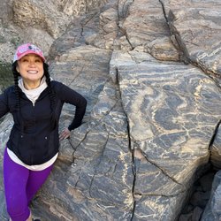
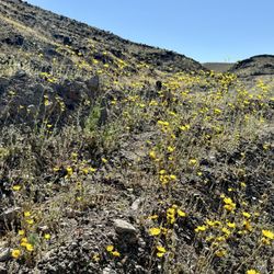
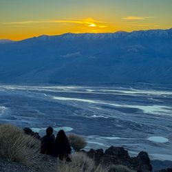
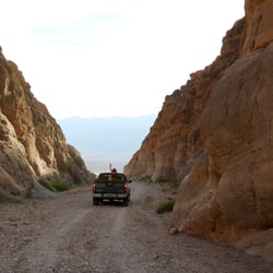
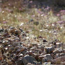
Of all the places we visited as a family for Spring Break in Death Valley, Fall Canyon was my favorite. Situated in the northern half of the park, Fall Canyon is accessed via a 3 mile road off the main highway, consisting of dirt, sand, gravel, and rocks up to about the size of a cantaloupe-- not impossible to pass in your 1994 Ford Festiva, but I wouldn't recommend it. The park map suggests a "high-clearance vehicle," which means the few extra inches under a Jeep, a truck, or an SUV could mean the difference between making it to the gravel-covered parking lot, or blowing out your exhaust system on the rocks... the latter could prove to be life-threatening in the heat of the desert. That said, before setting out on any hike in DV, be sure to prepare: even traveling with my 4x4 truck, we carried two gallons of water per person in the truck, with Camelbacks that stored 3 liters of water each during our hikes, plenty of shelf-stable snacks like dried fruit, nuts, and trail mix, sunscreen, a couple of lighters, a good knife, light clothing, hats, a first aid kit... I know, rather Boy Scout of us, but you don't take chances when you're traveling on the periphery of civilization with young kids. Phones generally don't work here. Now that all the worry stuff is out of the way... Fall Canyon is desolate and beautiful. Unlike any canyon in my local San Gabriel mountains, Fall Canyon's stark rock walls, carved by aeons of occasional swift moving flash flood waters, rise in stark contrast from the flat canyon bottom of gravel and rocks. This place is a rockhound's dream: if you know where to look, a geology enthusiast can find pre-Cambrian igneous rock (that's nearly 1.7 billion years old, Mildred), limestone, sandstone, breccia, conglomerate, mudstone, quartz, quartzite, gypsum, and maybe even a few other surprises, brought here from far away by fast moving waters. During our trip in April, the area was flecked with colorful wildflowers, growing in earnest against the deadly heat just a few weeks away, and providing food for voracious hornworm caterpillars, eating as fast as they could. A beautiful collared lizard crossed our path, and we had a brief photo-shoot with it before releasing it unharmed. As the sun went down, lots of bats emerged from the caves in the canyon walls, feasting early evening insects. With young kids, we only journeyed about a mile and a half into the canyon. In some places, the slot canyon narrows, while in other areas, it is wide; in most cases, the steep walls on either side keep you directly on the path. I can't wait to return to this area either sans offspring or when they are a little older and can carry their own water, to further explore the deeper parts of this beautiful area. read more


11 years ago
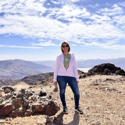
NO FALLING, JUST A LITTLE SLIPPING!!!! BACKGROUND: Fall Canyon is one of many colorful ravines in the hills surrounding Death Valley in California; shaped by occasional flash floods that flow from the higher mountains beyond, the canyon is remote and little-visited; deep and moderately narrow for many miles, with occasional shaded, cave-like passageways of great beauty. Some of these narrow, twisting sections are enclosed by smooth granitic walls with an unusual bluish tint. As with most other Southwest canyons, the rocks are layered, but quite differently to the orderly slot canyons of Utah - here the strata are multi-colored, buckled, twisted and eroded, the result of ancient geological forces. Fall Canyon is easily reached and offers a perfect wilderness experience, though it should be avoided during the summer months when the weather becomes too extreme. STATS: Distance: 9 miles Elevation Gain: Approx. 2,200ft. or roughly 400-500ft./mile ESSENTIALS: At least 2 liters of water Know your limits Comfy hiking shoes with good lugs Layered Clothing High protein food/snacks Electrolytes Camera Hat (optional) Sunscreen Trek poles (optional) High profile vehicle (strongly recommended) OUR ROUTE: Before heading home from a magically majestic weekend in Death Valley, me and The Crew headed here to Titus-Fall Canyon for a quick in-&-out. The drive from the paved road to the trail head was more than a little dirty and dusty, it was quite bumpy, thank goodness for high profile vehicles. Low profile cars would probably bottom out and leave a trail of car parts on the road. From the trailhead we headed up a soft sandy wash for about three miles, similar to the one at Furnace Creek. There is very little elevation gain, so it's completely doable for beginner hikers. It's the sandy wash provides a quad workout. The canyon closes in a smidge and provides some shade and the shadows created by the slightly limited shinning sun creates some breathtaking sites and colors of the slot canyon. The slots in this canyon don't get so narrow that packs have to be removed, and there's no need to spoon to the left or spoon to the right to get through. There are offshoot slots throughout this wash, which are worth taking a gander, especially if you are not wanting do all nine miles of this hike. Although there are no signs leading you to the end of the trail, the mouth of a 30ft. waterfall will be your sign that the end is here. DISCLAIMER: Hiking is not something that can be taken lightly. It can be life-threatening as you see and hear on the news, people die or get lost all time. Please, if you are going to hike, never go alone and prepare for the worst, hope for the best. Remember when going for a hike, no matter how short you think it may be, always be prepared. Carry at least two liters of water for every five miles (more if the weather is warm), protein bar, nuts, and electrolytes. Wear sturdy lug sole shoes and protective clothing. Some areas the weather can change quicker than a fireman can put on his gear. It is also very important, always always always let a family member or friend know where you are going and when you expect to be back. Lastly, have fun when you hike it up. Review 86 Yelp 100+ Challenge 2015 #deathvalley #hikingdeathvalley #hiking #belowsealevel read more

16 years ago
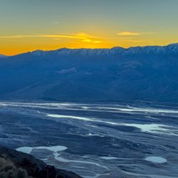
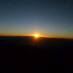
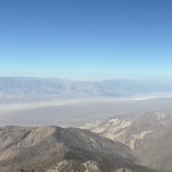
Slot canyons are formed when sudden flash floods gouge deep cracks out of the soft alluvial sandstone of a desert floor. Over millenia, the cracks can deepen to 20 meters or more without ever widening at the bottom to more than a meter. Rock falls (called "dry falls") often block these remote, steep passages with enormous boulders ("chokestones") that require agility and patience to climb. All of which should serve as a warning to the unwary - these formations are not for the casual tourist. They are inaccessible and dangerous, and if anything goes wrong, it could be weeks before anyone shows up to notice. And if a flash flood occurs, there is nothing you can do about it. People die every year in these canyons - but then people die every year crossing Broadway in Manhattan. It is all a matter of taking precautions. The largest concentration of slot canyons in the world lies in the American Southwest, in a rough line from southern Utah through Page, Arizona, to Death Valley. The canyons of Death Valley are some of the roughest and most spectacular. The best of these is Fall Canyon, in the north of the Park. You get to Fall Canyon from Titus Canyon. Titus is drivable, but one-way, so you have to access it from Nevada on Route 374 southwest of Beatty. Just before Titus empties into Death Valley Wash in the Park, there is a parking lot on the left and the entrance to Fall Canyon. And if Fall strikes you as too ambitious, the drive through Titus is itself an experience of a lifetime. For the novice, there are less difficult slots in the Park - Mosaic and Grotto near Stovepipe Wells, or the anonymous canyon on Artists Drive (on the right at the second major dip in the road). Whatever you do, start by visiting the Ranger Station at Furnace Creek, talking to the Rangers, and perusing the many excellent unpublished local guides available there. A few things to keep in mind: If you plan on taking photographs, you need to be in position by 11:00AM. The photo pictured here was taken at 13:00 on a bright, sunny day. You climb these canyons very slowly, with frequent stops to let your lungs (and adrenalin) recover. So start much earlier than you would expect. All the guides tell you that the hardest part is coming back down. They are not exagerrating - this is where most injuries occur. Keep very careful track of how you navigate upward, so you don't end up, like we have, hanging by your fingers above a 3-meter drop with no ledge where you thought there was one. Never climb alone, never climb if there is the slightest chance of rain within 100km (mainly in summer), and bring at least 2 litres of water per person. With all these caveats and warnings, we still recommend these slot canyons as the most spectacular experience you will ever encounter in an American desert. It will remind you of the first time you walked through a cathedral - only with your shoulders brushing the walls and the nearest human being a world away. Photos are a weak substitute for this adventure you will never forget. read more

More info about Fall Canyon


Fall Canyon - hiking - Updated July 2026
Best of Death Valley
People found Fall Canyon by searching for…
Parks in Death Valley, California
Things to Do in Death Valley, California
Swimming Holes in Death Valley, California
Hiking Trails With Waterfalls in Death Valley, California
Off Road Trails in Death Valley, California
Secret Spots in Death Valley, California
Fishing Spots in Death Valley, California
Picnic Areas in Death Valley, California
Things to See in Death Valley, California
Sunset View in Death Valley, California
Swimming Lakes in Death Valley, California
Attractions in Death Valley, California
Scenic View in Death Valley, California
Tent Camping in Death Valley, California
Walking Trails in Death Valley, California
Caves in Death Valley, California
Running Trails in Death Valley, California
Scenic Overlook in Death Valley, California
Sand Dunes in Death Valley, California
Photo Spots in Death Valley, California
Places to Visit in Death Valley, California
Easy Hikes in Death Valley, California
Browse Nearby
Browse Brands
Browse Articles
People who viewed Fall Canyon also viewed
Salt Creek Trail
4 reviews
Aguereberry Point Death Valley Natl Park
6 reviews
Telescope Peak
2 reviews
Keane Wonder Mine Trail
1 review
Natural Bridge Canyon
7 reviews
Golden Canyon
19 reviews
Harmony Borax Works Interpretive Trail
10 reviews
Father Crowley Vista Point
11 reviews
National Park Roadside Rest Stop
2 reviews
Big Dune
6 reviews