Mosaic Canyon Photos


More like Mosaic Canyon
Recommended Reviews - Mosaic Canyon
Start your review...

Reviews With Photos

I have been to DVNP 2x but this last trip in March 2022 was the first time we visited Mosaic Canyon. It is located very close to stovepipe wells, there is a bumpy dirt road about 2-3 miles long, not bad, just go slow. The canyon is neat with some different colored rock formations, different textures, etc. Be careful as there is 1 spot you need to climb up and it has some very smooth rock, like it was polished by the wind or water or both and many people were slipping trying to get up. We didn't go all the way to the end because some other hikers said it was not worth it and looked a lot like the rest of the canyon, and we had other places we wanted to check out more.


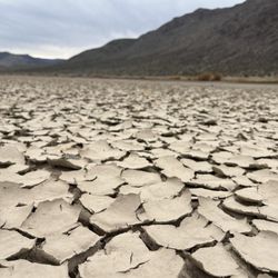
Visited during December 2021, a great season to visit Death Valley. The Mosaic Canyon trail was our pick for a couple hours' hike in the area before we moved on towards the scenic viewpoints of Zabiskie Point and Dante's View. Thanks to AllTrails.com, I knew this trail had some rock scrambling somewhere in the 1.7 miles out and back. There was a canyon that opened up to some beautiful rock canyons, some looking smooth as marble, some looking like compacted soil on its way to being sedimentary rock, and flint rocks and thin, layered rock too. So colorful and when we did get to the rock scrambling areas, which were quite fun! We had to find small footholds or other ways around the areas, and saw few people there once we got past that area. I would say be prepared for some flexibility, we saw some hikers of all ages that turned back once you had to shimmy over the narrow areas, so be aware they are coming up. Once through the scrambling areas in the narrow slot canyon, we hiked a bit more and missed a giant arrow made of rocks on the ground in between two canyons to see where the next area was. Once you follow the arrow up, it leads around to a descent into a smaller canyon (with darker and darker rock/soil below our feet) until we saw an impassable 25 feet dryfall, with "ENDE" and "终点" spelled out there. SUMMARY: A cool hike, can't imagine doing it in other seasons as there are not many areas for cover or shade. Bring water and sunscreen and hats, and be prepared for rock scrambling and awesome geological formations!


Walled with both mosaic conglomerates and smooth marbleized rocks, Mosaic Canyon is probably my favorite hike at DV. Like walking through an art exhibit. If you want views, recommend hiking up the trail on the left once you enter the open wash area. Location: Right by Stovepipe Wells, road is Mosaic Canyon road which you will drive on a bumpy gravel road for about 2 miles.

Easy to moderate hike hike of 2 to 4 miles out and back. In the first mile you walk though some smooth granite rock formations in a narrow slot. Fun to slide down some are so so smooth. Hop up and over some of the dry falls rocks and boulders to get into the higher elevation extending the hike. The hike is easier than the 2 mile gravel wash board bumpy bumpy road to the parking lot. After the hike go to the Stovepipe Wells saloon for a craft beer--you earned it!

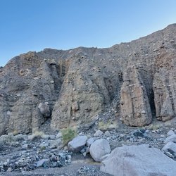
Mosaic Canyon is located on Hwy 190 (like everything else, it seems). If you're heading south from Scotty's Castle or Mesquite Spring campground, then you'll see the sign for the canyon on the right. It's close to Stovepipe Wells village. If you're heading north form Furnace Creek, then it'll be on your left side. Mosaic Canyon has hikes for all fitness levels. If you're a beginner, then you'll probably want to walk on the trail, which has practically no elevation gain. The distance also varies, depending on how far you want to go. If you're pressed for time, then it's probably a good idea to hike a mile or so in and then head back. Now, if you're the adventurous and curious type, then you'll want to explore further. My party if of the latter, so we walked beyond where most people would turn back. Once you're past the trail, the canyon becomes a lot more fun. There are no obvious trails, instead, you'll be doing some rock scrambling up walls. It's easier than it looks if you look around for passable routes. The rock is polished from the rushing water, but there are hand and foot holds. You'll just have to look and feel for them. The canyon is so quiet and peaceful the further in you go. It's a slot canyon with polished, white marble like rocks on both sides. There are definitely photo opportunities so have your camera handy. Also, if you're planning on visiting in the winter, I recommend that you layer your clothing. There are parts of the canyon that are sunny and others that are cooler. Also, bring water and sneakers or hiking boots are highly recommended, especially if you're planning on extensively exploring the canyon. Happy trails!

3 months ago
The only hike we really did at Death Valley NP. It's about 2-3 miles RT with some incline and a large stretch of uncovered trail so bring sunscreen and plenty of water! There are some challenging climbing pieces through slot canyons and some parts where you have to decide what is actually the trail. Then the end it kind of abruptly has a rock wall so there's no 'viewpoint' at the end but the rock marbling and mosaic rocks along the way are very cool to see. We saw a lot of groups here doing like discussion circles so seems like a popular spot to walk a little in and hang out. read more


Beautiful dry hiking trail. Reminds me of Zion Narrows without the water. Some bottleneck boulder scrambling from time to time. Arrows made of rocks point the way. Stay on trail. One guy had to be rescued by helicopter in the last year. Very dry terrain. Bring extra water. Limited shade. I suggest using the restroom at Stovepipe Wells first. No cell service. Better go near wintertime. Can be cold, so layer up. Summer can reach over 120°F. We hiked almost 4 mi for about 2 hr. read more


2 years ago
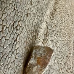
The 2.3 mile unpaved Mosaic Canyon Road is located in Stovepipe Wells Village, just across from Stovepipe Wells Campground. The road to the trailhead is passable in a sedan. From the parking area, at the trailhead, proceed up the rocky wash and into the canyon. Within the first 0.25miles, the canyon abruptly narrows as the smooth marble walls of Noonday Dolomite surrounding you. The passing of flash floods have scoured the narrow canyon and polished the smooth marble walls to a beautiful finish. You must approach with cautions due to serious slippery slopes. Although the trail seems blocked with huge impassable boulder, don't stop and believe it's the end of the hike! Be Adventurous! Try to squeeze between the narrowed boulders on the left side of the trail in order to gain access to the hidden bypass route. Look out for the arrows on the trail! The smooth surfaces composed of colorful breccia chutes and two vertical dryfalls in a dramatic amphitheater hidden within tight canyon bends are at the end of the trails! The welcome surprises will be your rewards! It took me two hours to reach the end of Mosaic Canyon at a four miles total in and back. Enjoy! read more


I have been to DVNP 2x but this last trip in March 2022 was the first time we visited Mosaic Canyon. It is located very close to stovepipe wells, there is a bumpy dirt road about 2-3 miles long, not bad, just go slow. The canyon is neat with some different colored rock formations, different textures, etc. Be careful as there is 1 spot you need to climb up and it has some very smooth rock, like it was polished by the wind or water or both and many people were slipping trying to get up. We didn't go all the way to the end because some other hikers said it was not worth it and looked a lot like the rest of the canyon, and we had other places we wanted to check out more. read more


3 years ago
Fun hike place! We enjoyed walking and taking photos between these beautiful and giant rocks. The rocks are very pretty by themselves. The nature is magic. read more

Visited during December 2021, a great season to visit Death Valley. The Mosaic Canyon trail was our pick for a couple hours' hike in the area before we moved on towards the scenic viewpoints of Zabiskie Point and Dante's View. Thanks to AllTrails.com, I knew this trail had some rock scrambling somewhere in the 1.7 miles out and back. There was a canyon that opened up to some beautiful rock canyons, some looking smooth as marble, some looking like compacted soil on its way to being sedimentary rock, and flint rocks and thin, layered rock too. So colorful and when we did get to the rock scrambling areas, which were quite fun! We had to find small footholds or other ways around the areas, and saw few people there once we got past that area. I would say be prepared for some flexibility, we saw some hikers of all ages that turned back once you had to shimmy over the narrow areas, so be aware they are coming up. Once through the scrambling areas in the narrow slot canyon, we hiked a bit more and missed a giant arrow made of rocks on the ground in between two canyons to see where the next area was. Once you follow the arrow up, it leads around to a descent into a smaller canyon (with darker and darker rock/soil below our feet) until we saw an impassable 25 feet dryfall, with "ENDE" and "终点" spelled out there. SUMMARY: A cool hike, can't imagine doing it in other seasons as there are not many areas for cover or shade. Bring water and sunscreen and hats, and be prepared for rock scrambling and awesome geological formations! read more


6 years ago
This canyon had very nice views and the entire park as well hope you guys enjoy it as much as I did and enjoy the work of art I created for you all read more

8 years ago
9 years ago
Walled with both mosaic conglomerates and smooth marbleized rocks, Mosaic Canyon is probably my favorite hike at DV. Like walking through an art exhibit. If you want views, recommend hiking up the trail on the left once you enter the open wash area. Location: Right by Stovepipe Wells, road is Mosaic Canyon road which you will drive on a bumpy gravel road for about 2 miles. read more


Easy to moderate hike hike of 2 to 4 miles out and back. In the first mile you walk though some smooth granite rock formations in a narrow slot. Fun to slide down some are so so smooth. Hop up and over some of the dry falls rocks and boulders to get into the higher elevation extending the hike. The hike is easier than the 2 mile gravel wash board bumpy bumpy road to the parking lot. After the hike go to the Stovepipe Wells saloon for a craft beer--you earned it! read more


Mosaic Canyon is located on Hwy 190 (like everything else, it seems). If you're heading south from Scotty's Castle or Mesquite Spring campground, then you'll see the sign for the canyon on the right. It's close to Stovepipe Wells village. If you're heading north form Furnace Creek, then it'll be on your left side. Mosaic Canyon has hikes for all fitness levels. If you're a beginner, then you'll probably want to walk on the trail, which has practically no elevation gain. The distance also varies, depending on how far you want to go. If you're pressed for time, then it's probably a good idea to hike a mile or so in and then head back. Now, if you're the adventurous and curious type, then you'll want to explore further. My party if of the latter, so we walked beyond where most people would turn back. Once you're past the trail, the canyon becomes a lot more fun. There are no obvious trails, instead, you'll be doing some rock scrambling up walls. It's easier than it looks if you look around for passable routes. The rock is polished from the rushing water, but there are hand and foot holds. You'll just have to look and feel for them. The canyon is so quiet and peaceful the further in you go. It's a slot canyon with polished, white marble like rocks on both sides. There are definitely photo opportunities so have your camera handy. Also, if you're planning on visiting in the winter, I recommend that you layer your clothing. There are parts of the canyon that are sunny and others that are cooler. Also, bring water and sneakers or hiking boots are highly recommended, especially if you're planning on extensively exploring the canyon. Happy trails! read more


4 years ago
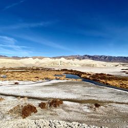
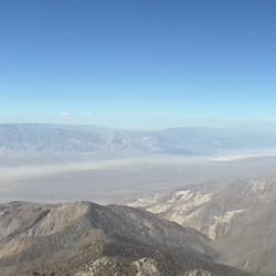
MOSAIC CANYON is located near the village of STOVEPIPE WELLS. One can walk from Stovepipe Wells to the trailhead at Mosaic Canyon or one can drive to the trailhead on the 2-mile dusty road. I have toured Death Valley National Park on eight separate weekends, where my goal was to photograph Mesquite Dunes. Since these dunes can only be photographed between the hours of 6-10 am and 3-6 pm, that leaves many hours in between that need to be occupied by other activities. (The bright sun of mid-day washes out the features of the dunes, and for this reason the dunes cannot be photographed in the mid-day hours.) Mosaic Canyon is a convenient place to explore at any time of the day. The multi-colored layers in the walls of this canyon are interesting, and those educated in geology are likely to be compelled and fascinated by Mosaic Canyon. I took photos of two types of geologic formations (see my posted photos), one of which is smooth and beige/pink colored, and the other of which has diamond-like patterns and has the color of coal. I had brought along a water-spray bottle, because I wanted to bring out the colors and contrast in the geological patterns. The water-spray worked fine in bringing out the contrast, but in my opinion, people who use this technique (and also people who do not have any water-spray) will want to increase the contrast even further using Photoshop. Anyway, I made only one visit to Mosaic Canyon. I also made separate trips to explore Golden Canyon, Artists Pallate, and Ubehebe Crater. Also, I spent a couple of hours exploring the hills along Jubilee Pass Road for taking photos of the charming arrangements of desert holly that form polka-dot patterns on these hills. read more


8 years ago
12 years ago
10 years ago
11 years ago
10 years ago

More info about Mosaic Canyon
Hwy 190
Death Valley, CA 92328
Directions
Hours
Outdoor Amenities
Ask the Community - Mosaic Canyon
Is it a place that I can visit with my 1 year old? Which spots I can see in Death Valley with almost no hike to little hike with my 1 year old toddler?
I don't think this would be a good place to take a 1 year old, it would be a pretty tough hike for a small child. Ash Meadows National Wildlife Refugee is just outside the east side of the park and would be perfect for a 1 year old. You could also…
Review Highlights - Mosaic Canyon


Mosaic Canyon - hiking - Updated August 2026
Best of Death Valley
People found Mosaic Canyon by searching for…
Things to Do in Death Valley, CA
Campgrounds in Death Valley, CA
Hiking Trails in Death Valley, CA
Camping Cabins in Death Valley, CA
Natural Hot Springs in Death Valley, CA
Secret Spots in Death Valley, CA
Off Road Trails in Death Valley, CA
Night Hike in Death Valley, CA
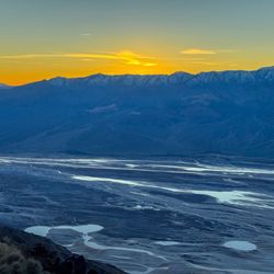
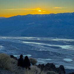
Photo Spots in Death Valley, CA
Playgrounds in Death Valley, CA
Things to See in Death Valley, CA
National Parks in Death Valley, CA
State Parks in Death Valley, CA
Camping Sites in Death Valley, CA
Places to Visit in Death Valley, CA
Scenic View in Death Valley, CA
What to Do in Death Valley, CA
Easy Hikes in Death Valley, CA
Sand Dunes in Death Valley, CA
Browse Nearby
BEST of Death Valley, California Things to Do near Mosaic Canyon
BEST of Death Valley, California Coffee near Mosaic Canyon
BEST of Death Valley, California Restaurants near Mosaic Canyon
BEST of Death Valley, California Breakfast near Mosaic Canyon
BEST of Death Valley, California Campgrounds near Mosaic Canyon