Ubehebe Crater Photos


You might also consider
More like Ubehebe Crater
Recommended Reviews - Ubehebe Crater
Start your review...

Reviews With Photos


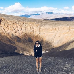


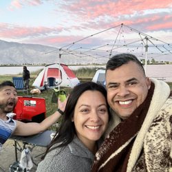
Wow! This is a pretty spectacular dormant volcanic crater to visit. Beautiful hues of orange and greys that will captivate you. It's about 40 mins from the Furnace Creek campsite and is worth checking out. You can also get a small uphill hike around the crater or downhill to the center of the crater itself. A must visit in Death Valley! read more


How many times in your life time will you see a crater? Exactly! So we decided to check out Ubehebe Crater despite behind quite a drive within the park to get there! Gas up and be patient, this is far. You should plan accordingly to visit it during your trip. We started our 2nd day in the park driving to it. Unfortunately, Scotty's Castle is being closed for renovations so we couldn't check it out while we were heading in that direction. The crater is about 8 miles passed the Castle which you won't be able to see from the road! Also, before you get closer to the Castel, there's a Ranger station! It's your last chance to use a restroom, so stop by! I wish they had a few more signs on the way, because you are in the middle of nowhere. But it's all paved roads, the main road, then follow the sign! Once you get there, there's a big parking lot and the Crater! Right then and there! And then, suddenly, the drive was worth it! The view is breathtaking, the crater is huge, a beautiful Mars-like landscape, unique in its vastness. The crater was formed by a massive volcanic steam explosion a few thousand years ago, you can see some black volcanic rocks on the trail. There is a trail to the bottom of the cone. We didn't hike it since we read it's steep coming up. But we walked on the ridge for a while and it was just us and the crater. Not too many people around, it's further away so it has less visitors than other parts of the park. It was pretty peaceful and serene. Driving back down it's a tad like a rollercoaster ride, but the Crater is one these place you won't forget! It's an adventure worth having! read more


To me this is one of the most fascinating places I've ever been. To be in, on and around an actual volcano is amazing. This is a drive and far away from mostly everything since Scotty's Castle is closed due to flooding. There are no toilets or anything but beautifully eerie landscape. Great hike around the rim. Truly breath taking. Personally I feel this is a must see and a highlight of DV. read more


5 years ago
Definitely the highlight of our trip. We have seen some crater before in AZ but to be able to hike down the crater? I am totally in and nope it's not a hard hike, not until you need to come up Going down is super fun, we saw some group even race the steep incline to get down to the bottom. It's definitely worth it. I didn't think much about the hike back, there are so many interesting stuff to occupied my interest once I am in the bottom of the crater. I was surprised to find so many live plants at the bottom of the crater. So many different rock formations. On one side there's lava rocks and on the other side there's cinders and cinder cones. Time to climb back.... here are some tips to make the upward hike a bit easier. Don't look up so much, it will discourage you. Just look what's in front of you and focus on each step. Try to just use the tip of your toe and follow the footprints that others left before you. Make sure you got water and take adequate breaks when needed. We are not expert hiker and we stoped three times to enjoy the view once again, took our water break and that 600+ feet wasn't so bad after all. Next time I will walk the rim. Yes we will definitely come back again. read more


On April 6th a group of us stopped here for a visit and I really liked it. Ubehebe Crater is located in the north end of Death Valley National Park near the Eureka Dunes and Scotty's Castle. There's a parking lot along the rim that provides a great view of the crater. Ubehebe Crater is a volcano that was created by a phreatic eruption about two thousand years ago. There are three trails to chose from. Option 1: hike "Down the crater" This trail leads off with a quick easy descent to the crater floor, but the steep 600-foot climb back to the rim may take longer. Option 2: "Little Hebe Trail" which I took was easy. This one-mile out-and-back that follows the western rim to a much smaller adjacent crater, Little Hebe which is similar but less colorful. Option 3: "The Rim Trail" you just continue past Little Ubehebe on this 2-mile circuit around the crater back to the parking lot. read more


Ubehebe is a Shoshone Indian word meaning "big basket in the rock." After touring Scotty's Castle, I came here to hike the crater. I drove by it on the way to the Racetrack and I had been on the edge several years ago, but this time I came prepared. I hiked from the parking lot to the base of the crater first. It's only 1/4 mile down. There's an elevation loss of 500 feet so coming back out will be hard for some who are not used to climbing up in loose gravel. I saw several people who turned around part way down. After seeing the bottom, hike back out and then follow the trail clockwise around the crater. It's a total distance--including the hike to the bottom and back out--of about 2.3 miles. By doing the hike clockwise, when you come back to your car, the end of the hike is downhill. There is a trail that runs along the rim of the crater and there's a side trail going to Little Ubehebe. The hike is worth it because the rocks show different colors as you change your position with the sun. This is a great way to spend some time in Death Valley, one of the most interesting places in the West. read more


8 years ago
...And who said there's nothing in the desert!? Our first stop on our Death Valley adventure for spring break! Worth the drive and constant feeling of "Is that it?!" Believe me, when you see it, you'll know that's it. Created from rock explosions , the Ubehebe Crater is large and in charge. You can walk around the top of the crater, or if you're feeling adventurous, trail down inside and you'll feel so small compared to everything around you. There's a lot of loose gravel, so it's easy to walk on and if you're a fan of incline, welcome to heaven my friend. I mean, it's not every day you see a crater, so my jaw dropped when I walked up to this place. The massive size alone is picture-worthy, but the surrounding mountains make for the most spectacular view. Drive up and drop in to this crater for an amazing hike, view, and something truly unique to your desert road trip. read more


6 years ago
Cool spot to checkout while in Death Valley. I was amazed by the vivid, natural colors in and around the crater. While there we did loop around the rim which was a great way to see the crater from different vantage points. It was a little tougher "walk" than I expected due to the loose rock, and the up and downs. We opted not to hike into the crater as it looked like a STEEP hike back up and we had already done some hiking earlier that day and had more planned later in the day. It was an hour plus drive from the 190 turn off so while I enjoyed my visit, I'm not quite sure it's worth the time to get there. read more


So, believe it or not, I've actually seen many giant holes in the ground. Bandera Volcano in New Mexico, Meteor Crater and the Grand Canyon in Arizona, Bryce Canyon in Utah.... At this point I've reached a place in my life where I can say, "Oh, there's another hole in the ground. Cool. Now let's go." But I am going to be fair here for those of you that have yet to experience a giant hole in the ground. A few minutes drive from Scotty's Castle, make the stop to see Ubehebe. It's a paved road and has a large parking lot right next to the crater. The crater is from an old volcano and is half a mile long and 500 feet deep. We saw people at the bottom when we were there. I considered hiking down to do something different with a giant hole in the ground, but then decided the sides were too steep and I'd wind up needing a helicopter to get me back out. Good luck if you go for it! You can walk around the crater and I saw signs for a trail to Little Ubehebe, but we were short on time and decided what we saw was good enough. Notes: This is the last bit of paved road before you hit the road for Racetrack Playa. We saw several cars driving toward it and I wished I could follow. However, we did not have a 4WD and I felt uncomfortable driving there in our car. Also, it was CRAZY windy up here when we visited. I'm not sure if this is normal, but I would say be prepared for it. I literally almost couldn't get my car door open because the wind was so strong. read more

Ubehebe Crater was one of the coolest and most impressive things we saw during our trip to Death Valley. Neither my friend nor I even knew about the crater until we saw a bunch of cars parked at an elevation and my friend decided to stop and see the commotion. The crater is massive and I have no words to describe how amazing it simply is. You can hike down the crater, which I would've like to done but it was incredibly windy, gusts at around 40mph. It was intense. We just snapped some photos and hopped back into the car. We did drive by again on our way home and it was less windy, but we had no time. Next time I'm back in Death Valley, hiking the crater will definitely be at the top of my list! read more

8 years ago
Hey, it could happen just 800 years ago and it could happen again. Beautiful stripes on the wall and intoxicating colors during sunset. Easy to go and worthy of the walk (not even a hike hah). So it can be for everyone. read more

Awesome spot if you're willing to drive the extra miles to get there. Scotty's Castle was closed when we visited, so we stopped here on our way to the racetrack! Very awesome crater and easy to get to for photos. You can walk a little ways up to see the smaller crater of you would like as well, although we were stretched for time, so we skipped that. read more

13 years ago
11 years ago
It's so much fun saying "Ubehebe" (YOO-bee-Hee-bee), that it's almost worth driving out there just to have an excuse to keep repeating the word! But the fun name is not the only reason to see this crater; it is also gorgeous! If you hit it just before sunset, the light strikes the back wall of the crater, and you will be treated to a show of spectacular reds, oranges, and yellows in the exposed earth. It is well worth a visit, even if just for a quick park and view. It is an easy drive here from Scotty's Castle Road--only a few miles of smooth, paved road ending in a large parking lot--but to get to that turn-off is quite a distance from Furnace Creek (over an hour's drive!), so keep that in mind before you commit to a trip. You will, though, pass right by if you are on your way to Scotty's Castle or Racetrack Playa. When we were there in March 2016, there was no bathroom, even though I could have sworn that there had been one before. The nearest bathroom is now at the Grapevine Ranger Station. As for the hiking: the rim trail is a lovely stroll around the crater, though it does get perilously close to the edge at times, so keep an eye on small children. If you are tempted to adventure down into the crater, a wide trail of deep black gravel will take you down there, but be prepared for a long, slow slog back up! There's not a lot down there to see except the glow of your own awesomeness for doing it! read more


10 years ago
8 years ago
13 years ago
7 years ago
12 years ago
More info about Ubehebe Crater
Ask the Community - Ubehebe Crater
Do u need 4wd to get up to the crater?
No, you don't need 4wd to get to the crater. All paved, just was a little bumpy in spots where debris had washed over the road a one point but totally drivable without 4wd.
Review Highlights - Ubehebe Crater


Ubehebe Crater - parks - Updated May 2026
Best of Death Valley
Browse Brands
Browse Articles
People found Ubehebe Crater by searching for…
Things to Do in Death Valley, California
Campgrounds in Death Valley, California
Hiking in Death Valley, California
Fishing Spots in Death Valley, California
Natural Hot Springs in Death Valley, California
State Parks in Death Valley, California
Camping Cabins in Death Valley, California
Tours in Death Valley, California
Watch Sunset in Death Valley, California
Off Road Trails in Death Valley, California
Camping Sites in Death Valley, California
Hiking Trails in Death Valley, California
Night Hike in Death Valley, California
River Swimming in Death Valley, California
Playgrounds in Death Valley, California
Cliff Jumping in Death Valley, California
Secret Spots in Death Valley, California
Things to See in Death Valley, California
Running Track in Death Valley, California
Dog Swimming in Death Valley, California
Sand Dunes in Death Valley, California
View Points in Death Valley, California