Cottonwood Park Photos


You might also consider
More like Cottonwood Park
Recommended Reviews - Cottonwood Park
Start your review...

Convenient location, place to stop with my dogs after a drive from St George Utah on the way to Bishop. Fenced, dog potty clean up station, grassy areas and water station. Grass is over grown lots of fox tails, so watch your dogs. read more


I needed to find a park to have lunch after our visit to Rhyoilte and the Goldwell Open Air Museum. I looked on Yelp for parks in Beatty and it showed me Cottonwood Park. I didn't use Yelp to get directions but used my Car Play to ask for directions. Wrong thing tio do. It gave me Cottonwood Parks hundreds of miles away. Finally,I opened the Yelp app and got directions and we were right there. When we do day trips like this, my friend always packs some Taiwanese buns for lunch and we enjoy the open air dining as long as it's not August. Cottonwood Park is well kept. There are plenty of covered tables on the west side of the park. It's one block from the main roads in/out of Beatty so it IS easy to get to. We enjoyed our brief stop for lunch in Beatty. read more


More info about Cottonwood Park
Beatty, NV 89003
Directions
Hours
Outdoor Amenities


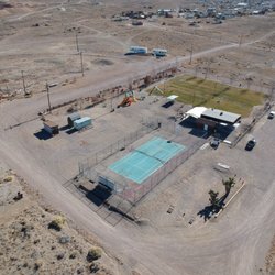


Cottonwood Park - parks - Updated May 2026
Best of Beatty
People found Cottonwood Park by searching for…
Things to Do in Beatty, Nevada
Public Showers in Beatty, Nevada
Picnic Areas in Beatty, Nevada
Running Trails in Beatty, Nevada
Watch Sunset in Beatty, Nevada
Walking Trails in Beatty, Nevada
Parks and Recreation in Beatty, Nevada
Places to Swim in Beatty, Nevada
Picnic Spots in Beatty, Nevada
Running Tracks Open to the Public in Beatty, Nevada
Things to See in Beatty, Nevada
Fun Things to Do at Night in Beatty, Nevada
Places to Go in Beatty, Nevada
Fun for Kids in Beatty, Nevada
Trending Searches in Beatty, NV
Browse Articles
Browse Nearby
BEST of Beatty, Nevada Restaurants near Cottonwood Park
BEST of Beatty, Nevada Things to Do near Cottonwood Park
BEST of Beatty, Nevada Coffee near Cottonwood Park
BEST of Beatty, Nevada Breakfast near Cottonwood Park
BEST of Beatty, Nevada Campgrounds near Cottonwood Park
BEST of Beatty, Nevada Shopping near Cottonwood Park
Browse Brands
Related Searches in Beatty, NV
Best Nature Trails for Hiking in Beatty, Nevada
Best Places for Horseback Riding in Beatty, Nevada
Best Places for Stunning Views in Beatty, Nevada
Best Spots for Star Gazing in Beatty, Nevada
Best Things to Do on a Rainy Day in Beatty, Nevada
Best Water Parks for Kids in Beatty, Nevada
Best Waterfalls and Swimming Holes in Beatty, Nevada
Check Out Off Road Trails in Beatty, Nevada
Discover Lakes & Ponds to Explore in Beatty, Nevada
Discover Top Nature Parks to Visit in Beatty, Nevada
Discover the Best Running Track in Beatty, Nevada
Enjoy Scenic Night View Experiences in Beatty, Nevada
Enjoy the Best Night View Spots in Beatty, Nevada
Enjoy the Best Picnic Spots and Ideas in Beatty, Nevada
Enjoy the Best Walking Trails in Beatty, Nevada
Explore Easy Hikes Perfect for All in Beatty, Nevada
Explore Landmarks & Historical Buildings in Beatty, Nevada
Explore Nature Spots Around Beatty, Nevada
Explore Popular Campgrounds Near Beatty, Nevada
Explore Popular Picnic Areas Around Beatty, Nevada
Explore Popular RV Parks Around Beatty, Nevada
Explore Popular Scenic Overlook Points in Beatty, Nevada
Explore Popular Scenic Views Near Beatty, Nevada
Explore Scenic Lakes to Visit in Beatty, Nevada
Explore Secret Spots Worth Visiting in Beatty, Nevada
Explore Top Gyms in Beatty, Nevada Now
Explore the Best Trail Options in Beatty, Nevada
Family Friendly Hiking With Kids in Beatty, Nevada
Find Fun Kids Activities Outdoor in Beatty, Nevada
Find Picnic Tables for Outdoor Fun in Beatty, Nevada
Find Top-Rated Waterfalls in Beatty, Nevada Now
Hiking Trails With Waterfalls in Beatty, Nevada
Must-See Tourist Attractions Around Beatty, Nevada
Perfect Spots to Watch Sunset in Beatty, Nevada
Picnic Areas With BBQ Pits Available in Beatty, Nevada
Popular Places to Take Pictures in Beatty, Nevada
Popular Things to Do in Beatty, Nevada
Popular Things to See in Beatty, Nevada
See Top Fireworks Events in Beatty, Nevada
Top Must See Attractions and Spots in Beatty, Nevada
Top Running Trails to Explore in Beatty, Nevada
People who viewed Cottonwood Park also viewed
Harmony Borax Works Interpretive Trail
10 reviews
Titus Canyon Road
6 reviews
Keane Wonder Mine Trail
1 review
Fall Canyon
3 reviews
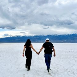
Death Valley National Park
393 reviews
Father Crowley Vista Point
11 reviews
Amargosa Park
1 review
National Park Roadside Rest Stop
2 reviews
Big Dune
6 reviews
Furnace Creek Stables
14 reviews