Artist Drive Photos


You might also consider
More like Artist Drive
Recommended Reviews - Artist Drive
Start your review...

Reviews With Photos

An amazing drive that's unfortunately tarnished by cyclists and cycling tours. RANT: Hopefully when you drive this road companies like REI and other private cycling tour outfilts aren't sharing this experience with you. The clientele of these tours are "privilege" and boy do they act like it. Sharing the road means pulling off to allow vehicles to pass. Don't expect any common sense or courtesy from the cyclists. Overall this is a fun drive that includes the Artist's Palette lookout. But there's a great viewpoint at the biggining of this drive at the first parking lot. Simply park and hike up to the top of the large black hill to get a great view of Death Valley.

Let me tell you something; you will fall in love with this drive! Don't miss it on your visit to Death Valley, especially if it's your first time visiting. The painted mountain tops are completely surreal to see on this drive. So many places to stop off and explore. You may feel like you're stopping every 3 minutes to get out of your car to take pictures and to explore, but this is precisely the point. Even if you don't want to stop, the drive alone is just so damn beautiful. It's amazing that these mountains are colored like this naturally. Imagine driving through the valley with huge colorful mountains as your view the entire time. Well, that's what it is. Just beauty all throughout. To be honest, I can't even tell you how long of a drive this really is because I was one of those people pulling over every couple of minutes to get out and explore. There's just so much to see. And if you're planning on doing this drive, make sure you stop at the Artist's Palette. You may think that you've already seen it since there are so many other stops before you get there, but look for a sign and a parking lot. I actually almost passed it up myself and thought that I had already seen it. Now, THOSE rock formations really do look like an Artist's palette. The drive is one way, so you don't have to worry about any oncoming traffic. Definitely a must when visiting Death Valley National Park!

Had to do the Artist Drive while visiting Death Valley! It's easy to find, marked, on the way to Badwater Basin. It's a one way road, a few miles that will seem longer, about 9 miles, full of twists and turns! Drive slowly and enjoy the ride! There are areas where you can stop and take photos. It's not super crowded so you take your time and pull aside as many times as you feel like it. One of the main spots is Artists Palette The views are wonderful, the rocks are pink, purple, turquoise because they got oxidized. There are many slopes all around you and great vistas! Another one of a kind sighting in Death Valley!

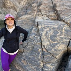
This is a great side road when visiting Death Valley NP. This one way spur off of Badwater Road. The road is paved and is about 9 miles in length. It does get narrow in spots and its impossible to pass other cars. But hey your there to look at scenery not recreate the Paris Dakar rally. The scenery on the road is spectacular to say the least. The oxidation of various minerals in the soil provide a myriad of colors from green, to red, to purple depending on the underlying material. Chemical weathering and other geothermal activity also help shape the scenery. Its also not an all day thing unless you hike (and lets face it who is hiking in 114 degree weather?) and best part a few activities like hitting up Badwater. As with any adventure in Death Valley, you need to make sure you have a vehicle in good working order, plenty of food and water (I pack in enough for 3 days per person on the trip...... I know its overkill but you don't want to be one of those groups featured in an unsolved mysteries etc.).


This is a drive down a one way road that takes you through the mountains where you experience breathtaking rock formations of many shapes and colors. The ride reminded me of the scenic drive in Cars ride from California Adventure, the theme song was even playing in my head as we drove down the path. It's really amazing and I enjoy how there are so many different things to experience in the park and not just repetitive sights. Sorry, I forgot to take photos with my cell so dont have many too share. I was snapping away with my digital camera. But it's amazing! Would recommend taking this drive!

Artist Drive is a one way drive.So it's better to go first to the Bad waters.What we did.After that we took a 9 mile loop drive to the Artist Palette.It was a kinda late and we had only one stop at the Artist Palette.Spectacular and stunning view.I can't express my feelings,amazing colors. Unfortunately we couldn't stay long, as it was too late and getting dark.We were there after 4p.m. I recommend first to have a map from the Visitor's center and come here earlier before 3p.m.We didn't account that it's getting dark in the mountains very fast. This place was on top of my list.I want to come here again to explore more places.

This is beautiful scenic loop to take after visiting Badwater Basin and before leaving the park through Furnace Creek. It's a nice little drive and the color on the canyons is pretty remarkable. We got out and took a few pictures but were too tired from exploring the rest of the park earlier in the day to go hiking. When I come back to Death Valley, I will definitely try to fit in time to hike farther in the canyons. Oh, and don't try to use the bathrooms. They're outhouses and the weather gets into the triple digits. I'll just let you imagine what that smells like. Hold it in and drive to Furnace Creek.

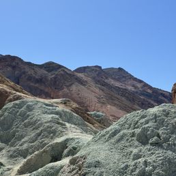
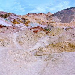
One of the many great surprises in Death Valley is the Artists Drive, which seems to lump triangles of rock together in oblique formations and then have a palette on hand to provide each with a little color detail. Sometimes the markings are striking and vivid, other times there are mere hints of coloration, which is brought on by the mineral components of the land beneath the surface. When the ground buckles, up come these mini-mountains, bringing the colors of sediment with them. The road which carries you along this very distinctive part of the park bounds along through some nice twists and turns with drops and climbs that are great driving fun. If you're in the park, it would be remiss not to spend some time here marveling at just one of the incredible variety of landscapes found within Death Valley.


24 days ago


9-mile Scenic Loop [Death Valley National Park] We've driven to Death Valley many times, and a few times we've stopped at scenic spots, Zabriskie Point, being my favorite. The first time around, we didn't even get close to the rainbow-like Artists Palette... the road wasn't yet paved and I didn't want to end up buying our rental car if somehow it got damaged by the rough road. Well, now the roads have been maintained and we finally had a chance to drive in it. Artists Drive is the most popular scenic drive in the park and I've been wanting to see the Artist's Palette since the road is now paved. It's a 9-mile one-way narrow road that twists, turns, and dips like a rollercoaster. Fun! It is a one way road... so no turning back. The drive includes vibrant desert hills, sloping mountain side and, of course, the main event...Artist's Palette. Artists Drive is a short detour off Badwater Road so, yes, we wanted to check out the beautiful colors of Artists Palette on the way back from Badwater Basin to Furnace Creek. Happy trails... Review #3534 read more


An amazing drive that's unfortunately tarnished by cyclists and cycling tours. RANT: Hopefully when you drive this road companies like REI and other private cycling tour outfilts aren't sharing this experience with you. The clientele of these tours are "privilege" and boy do they act like it. Sharing the road means pulling off to allow vehicles to pass. Don't expect any common sense or courtesy from the cyclists. Overall this is a fun drive that includes the Artist's Palette lookout. But there's a great viewpoint at the biggining of this drive at the first parking lot. Simply park and hike up to the top of the large black hill to get a great view of Death Valley. read more

1 year ago
Let me tell you something; you will fall in love with this drive! Don't miss it on your visit to Death Valley, especially if it's your first time visiting. The painted mountain tops are completely surreal to see on this drive. So many places to stop off and explore. You may feel like you're stopping every 3 minutes to get out of your car to take pictures and to explore, but this is precisely the point. Even if you don't want to stop, the drive alone is just so damn beautiful. It's amazing that these mountains are colored like this naturally. Imagine driving through the valley with huge colorful mountains as your view the entire time. Well, that's what it is. Just beauty all throughout. To be honest, I can't even tell you how long of a drive this really is because I was one of those people pulling over every couple of minutes to get out and explore. There's just so much to see. And if you're planning on doing this drive, make sure you stop at the Artist's Palette. You may think that you've already seen it since there are so many other stops before you get there, but look for a sign and a parking lot. I actually almost passed it up myself and thought that I had already seen it. Now, THOSE rock formations really do look like an Artist's palette. The drive is one way, so you don't have to worry about any oncoming traffic. Definitely a must when visiting Death Valley National Park! read more


Had to do the Artist Drive while visiting Death Valley! It's easy to find, marked, on the way to Badwater Basin. It's a one way road, a few miles that will seem longer, about 9 miles, full of twists and turns! Drive slowly and enjoy the ride! There are areas where you can stop and take photos. It's not super crowded so you take your time and pull aside as many times as you feel like it. One of the main spots is Artists Palette The views are wonderful, the rocks are pink, purple, turquoise because they got oxidized. There are many slopes all around you and great vistas! Another one of a kind sighting in Death Valley! read more


2 years ago
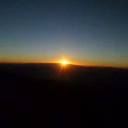
multi-colored mountains, different shades: blue, green, pink. Very unusual. the trail is not difficult. There is parking and restroom. the best time is at sunset or dawn. read more


This is a great side road when visiting Death Valley NP. This one way spur off of Badwater Road. The road is paved and is about 9 miles in length. It does get narrow in spots and its impossible to pass other cars. But hey your there to look at scenery not recreate the Paris Dakar rally. The scenery on the road is spectacular to say the least. The oxidation of various minerals in the soil provide a myriad of colors from green, to red, to purple depending on the underlying material. Chemical weathering and other geothermal activity also help shape the scenery. Its also not an all day thing unless you hike (and lets face it who is hiking in 114 degree weather?) and best part a few activities like hitting up Badwater. As with any adventure in Death Valley, you need to make sure you have a vehicle in good working order, plenty of food and water (I pack in enough for 3 days per person on the trip...... I know its overkill but you don't want to be one of those groups featured in an unsolved mysteries etc.). read more


4 years ago
It's a nice drive with a nice view. You can also stop and hike in the area. Always bring water because the sun and heat are intense during the day hours. Best time to visit is during the morning or after 5 PM. read more


3 years ago
9 miles one way drive from South to North, two office stops but I think you can pull over along the road. Very colorful mountain.definitely worth to visit! read more


5 years ago
This is a drive down a one way road that takes you through the mountains where you experience breathtaking rock formations of many shapes and colors. The ride reminded me of the scenic drive in Cars ride from California Adventure, the theme song was even playing in my head as we drove down the path. It's really amazing and I enjoy how there are so many different things to experience in the park and not just repetitive sights. Sorry, I forgot to take photos with my cell so dont have many too share. I was snapping away with my digital camera. But it's amazing! Would recommend taking this drive! read more

8 years ago
9 years ago
Artist Drive is a one way drive.So it's better to go first to the Bad waters.What we did.After that we took a 9 mile loop drive to the Artist Palette.It was a kinda late and we had only one stop at the Artist Palette.Spectacular and stunning view.I can't express my feelings,amazing colors. Unfortunately we couldn't stay long, as it was too late and getting dark.We were there after 4p.m. I recommend first to have a map from the Visitor's center and come here earlier before 3p.m.We didn't account that it's getting dark in the mountains very fast. This place was on top of my list.I want to come here again to explore more places. read more


This is beautiful scenic loop to take after visiting Badwater Basin and before leaving the park through Furnace Creek. It's a nice little drive and the color on the canyons is pretty remarkable. We got out and took a few pictures but were too tired from exploring the rest of the park earlier in the day to go hiking. When I come back to Death Valley, I will definitely try to fit in time to hike farther in the canyons. Oh, and don't try to use the bathrooms. They're outhouses and the weather gets into the triple digits. I'll just let you imagine what that smells like. Hold it in and drive to Furnace Creek. read more


10 years ago
One of the many great surprises in Death Valley is the Artists Drive, which seems to lump triangles of rock together in oblique formations and then have a palette on hand to provide each with a little color detail. Sometimes the markings are striking and vivid, other times there are mere hints of coloration, which is brought on by the mineral components of the land beneath the surface. When the ground buckles, up come these mini-mountains, bringing the colors of sediment with them. The road which carries you along this very distinctive part of the park bounds along through some nice twists and turns with drops and climbs that are great driving fun. If you're in the park, it would be remiss not to spend some time here marveling at just one of the incredible variety of landscapes found within Death Valley. read more

18 years ago
Wow, what a beautiful place to drive and Hike. Artists Palette is full of different minerals that give greens, oranges and purples in addition to the local brownery and white from salt or Borax. Watch for flash floods if any rains come up. Many Picture ops. read more

16 years ago
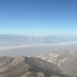
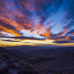
You reach Artists Drive off the road south from Furnace Creek to Badwater in the southern section of the park. The Drive is a loop that begins and ends on Badwater Road and runs one way south to north. You have to watch carefully for the entrance - it isn't obvious. The fuss here is over the ancient volcanic ashfalls. Over millions of years, weather and groundwater have transformed these clay hills into a rainbow of colors from aqua blue, to green, to carmine red. The most spectacular sight is actually a sub-canyon called the Artists Palette. The best time to arrive is an hour before sunset. When the sun's rays are refracted off the Panamint Mountains behind you, the Palette explodes into colors you would never believe. If you plan on trekking up the canyon, arrive earlier - this is not a place you want to find yourself after dark. On a map, Artists Drive looks like a fairly short road, but don't let this fool you. The pavement twists and turns through some of the deepest gullies and wildest turns in Death Valley. Even if you could exceed the 15mph speed limit, you won't want to - you'll be too busy gawking at the scenery. read more

15 years ago
A fantastic experience. I came to Death Valley to do some sight seeing with my family, and there were a lot attractions we had to choose between. Should you find yourself in a similar position, choose Artist Drive. The road winds through breathtaking, tightly packed hills and ridges, and is well worth taking just for the view while driving. Of course it gets better if you hop out of your car at Artist's Palette. This stop offers a view of some beautifully colored hills. I personally saw them at sunset, and their rich blues and purples were stunning in the fading light. Most of Death Valley has amazing landscape, but I think this is the best of the best. Check it out. read more

This winding 9 mile road is great if you only have a few precious hours to spend in the park. The road is one way and offers 2 opportunities to get out of your car and explore, the first one coming within 5 minutes of turning onto the drive. At first you see an explosion of color to your right but soon you are engulfed in a canyon with colors all around. This is an easy drive on a paved road so if you can't hike, have small kids with you or are short on time, take this drive to see the beauty of DV. read more

Very pretty and worth checking out by driving through. We went around noon and the colors weren't as vibrant and vivid as expected, and I've read that the saturation changes depending on light and time. The drive is a one-way loop on Badwater Road off Highway 178, so don't enter the wrong way! Grab a map from the Furnace Creek Visitor Center and that will help tremendously. read more


10 years ago
16 years ago
11 years ago
I wish I can give this destination a 3.5 instead of a 3. As the visitor guide stated, Artist's Drive is a 9-mile scenic loop drive through multi-hued volcanic and sedimentary hills. It is a one-way drive on Badwater Road so make sure you enter the right way. Don't worry there will be signs pointing you to the right direction. It is a 6-mile drive from the Furnace Creek Visitor Center. There are two dips where you can pull over at the small turnouts and hike and scramble. My friend and I pulled over at both of these dips and hiked until we couldn't hike anymore since we kept hitting deadends or rocks that looked wayyy to dangerous to climb unless you're an avid rock climber. I wasn't sure what we were suppose to see during these short hikes, but if you want to climb some rocks, scramble and get a small hike in, I would do it. It was cool to see the multi-color rocks and the mini canyons hidden in these mountains. It was especially pretty when the light would hit the canyons and the rocks in it. Photo op! Most people drive through to stop at Artist's Palette which is further down passed the dips. There is a small parking lot and restrooms available. Artist's Palette is best photographed in the late afternoon. It's pretty cool to see these unique colored geologic features. You can hiked throughout it. My friend and I only hiked a little bit since we were on a time crunch. The drive and Artist's Palette was nice but I wasn't especially WOW'd by the destination. I'm sure if you are a rock person, you'll definitely appreciate this. read more


12 years ago
If you are on your way to Badwater Basin or your way back this is a must. A short 8 mile drive on a one way windy road. It is absolutely breathtaking such a crazy array of colors greens, purples, orange and blues just stunning. There were parts where I thought the sand people of Star Wars were going to come out. Don't miss this turn it will be a highlight of your Death Valley trip. read more


8 years ago
More info about Artist Drive
Hwy 178/BADWATER Rd
Death Valley, CA 92328
Directions
Hours
Outdoor Amenities
Other Amenities
Artist Drive Reviews in Other Languages
Ask the Community - Artist Drive
Review Highlights - Artist Drive


Artist Drive - hotelstravel - Updated May 2026
Best of Death Valley
People found Artist Drive by searching for…
Things to Do in Death Valley, California
Visitor Centers in Death Valley, California
Parks in Death Valley, California
Scenic View in Death Valley, California
Natural Hot Springs in Death Valley, California
Off Road Trails in Death Valley, California
Watch Sunset in Death Valley, California
Tours in Death Valley, California
Sunset View in Death Valley, California
Travel Services in Death Valley, California
Hiking Trails With Waterfalls in Death Valley, California
Secret Spots in Death Valley, California
Mineral Hot Springs in Death Valley, California
Night Hike in Death Valley, California
Photo Spots in Death Valley, California
Running Trails in Death Valley, California
Things to See in Death Valley, California
Walking Trails in Death Valley, California
State Parks in Death Valley, California
Scenic Overlook in Death Valley, California
Hiking With Kids in Death Valley, California
Nature in Death Valley, California
Browse Brands
Related Cost Guides
Browse Articles
People who viewed Artist Drive also viewed
Dante's View
46 reviews
Devil's Golf Course
24 reviews
Golden Canyon
19 reviews
Furnace Creek Visitor Center
61 reviews
Natural Bridge Canyon
7 reviews
Fall Canyon
3 reviews
Armagosa Valley Rest Area
4 reviews
Keane Wonder Mine Trail
1 review
Telescope Peak
2 reviews
Ash Meadows National Wildlife Refuge Visitor's Center
6 reviews