Mojave Lava Tubes Photos


You might also consider
More like Mojave Lava Tubes
Recommended Reviews - Mojave Lava Tubes
Start your review...

Reviews With Photos - Mojave Lava Tubes

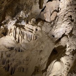
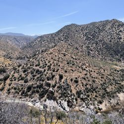
Definitely one of the weirder adventures I've embarked upon - and undoubtedly one of the most fun!! What a trip haha! Finally made it out here - been trying since the #localadventurechallenge put it on my radar last September but it was closed due to Covid I think (or a fire - can't remember lol). You'll drive waaaay out into the Mojave Desert, passing tons of gnarly Joshua Trees - and then spend another 40+ minutes driving down an insanely bumpy, rocky, sandy road. Then you'll finally see the little roundabout parking area with a sign for the tubes - get out and hike a tiny bit - I'd say about 1/2 a mile - unless you're like us and take the wrong trail lol - hiking past all these rocky lava rock explosions! Black and red and so rough and pointy - it's mind blowing how anything can grow outta this stuff! And then you'll finally stumble upon a gaping hole opening up into the desert floor with stairs leading down. At the bottom you'll think you should go right but you actually want to go left - the opening on the right looks like it caved in as it's full of rocks and dirt - don't go that way! When you go left, you'll have to climb over large lava boulders and it gets super dark so have your cellphone light or a flashlight - you'll need it for sure! And then BAM!!! It suddenly gets light and opens up into the coolest chamber!! If you time it right, you'll catch beams of light shining in through lava holes in the roof of the cavern. We were there mid morning and there weren't any beams until we started to leave - around 1030am ish I think - a tiny beam finally appeared! I definitely want to go back to catch the full light beam effects someday - but phew that ride in sure is tough! That being said, I highly recommend a rental car - and an elevated one - Bc you're gonna be going over some serious bumps and even some large rocks along the road. It's only about 5 miles of the Hell Road but it takes a good solid 40 mins or more to drive it Bc of the conditions. And you'll also see a fork in the road on the way in - stay to the left!! Supposedly if you go to the right, the sand is really deep and you'll get stuck! To get here I used google maps - and I had downloaded the offline map - DO IT - Bc there's no signal out here whatsoever. But google maps recognized Mojave Lava Tube and got us here nonetheless. Apple Maps was all kinds of wrong lol. I also recommend hiking boots - you don't HAVE to have them - but the ground is incredibly rocky and hard to traverse- I had on my vans and it was so tough. Hiking boots would've been much more comfortable! Oh and there's absolutely NO cell signal out there for miles - so just be safe - maybe don't come alone - let somebody know where you're going etc.

This was an unique experience especially if there are any sunlight shining through the cave. Probably better if you have a high clearance car to drive 5 miles off-road to this location. From the parking, it was about a ~10 minute walk to the cave. After you climb down the stairs, head left to the opening with a flashlight. Then, crouch down to get through this small opening. The cave was smaller than I thought and can fill up fast with people looking to get photos!

It's a tiny cave in the middle of nowhere and almost risked getting stuck on the off-road path en route to here but it was worth it. It's quite easy to miss the entrance, but you have to go about 5 miles on a reallllllllllllllly bumpy road that before you make it to a roundabout. Download an offline version of Google Maps; no reception here. Park at the roundabout, then walk up the slight slope and go to your right and you'll see a ladder. You can go down from there and and you'll find the cave after going under a narrow gap. It's quite nice temperature-wise compared to the sweltering heat outside. You will have to walk down stairs, as well as hunch down to get in the cave, so it's NOT handicap friendly, for those that want to know. I want to reemphasize that my 2WD low riding car made it after going between 5-15 mph for almost 35 minutes, and only scratched it up once towards the last 200 feet after the cul de sac, which honestly was a mistake and I should've parked at the cul de sac then just walk the short distance to get to the tubes. It's also next to Kelso Dunes so I recommend visiting this place in addition to the caves if you're out in the Mojave here.

Is an extremely easy jaunt up a slight slope to a fixed metal ladder. If you lose sight of your vehicle for more than a minute you've gone too far. You pass the second corral and there will be a small cul-de-sac dirt loop to your right a bit down the road. Unless you have an authentic 4 x 4 I would not suggest trying to go up the embankment which is about 200 feet to the ladder. When I went it was a weekday and there was nobody there. The road in, is very bumpy, sometimes graded and towards the end of the road has some sharp lava rocks so go easy. You do not require a 4 x 4 however it is suggested. I went in a sedan and the 4.2 miles took me about 35 minutes to go down because I needed to go so slowly. Definitely bring yourself water. And a flashlight, a headlamp if you have one. You will need both hands to go down the latter there are about 7-9 rungs, it's not very steep. You will need to duck to get into the larger portion of the cave. So when you reach the bottom of the ladder, you can make a right or a left. I suggest left. The left will take you out into the main cave area. The right is just a small dead end. As I stated it is very dark in there until you reach the area of the main cavern where there are portals for light comes through. It is safe enough for children to traverse. However I suggest leaving fido home. The rocks are sharp and probably not paw friendly. If you come out here enjoy the views. When I was out here I ended up hiking in additional 12 miles into the Mojave. If you're out here, you will hear a strange, deep booming noise occasionally. It's coming from the military base. I believe Fort Irwin. Nothing to fear just random bombing practices.

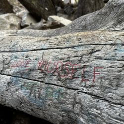
This is a very easy .5 mile hike to a beautiful cave with 2 light entry points that photograph very well! Quick read: yes, go it's worth it. But please try to leave the smoke bombs and manmade items out of the area! Some tips: 1: get gas before you head out. There aren't many stations near by. Not many restaurants open right now either so bring food if you want. 2: bring a phone flashlight or a real one just for the few feet of darkness. 3. Turn left at the sign that says lava tubes- there is no arrow. 4. The 5 mile road up to the trailhead is not at bad. Go slower over the rocks and around 30 on the washboard portions. You can take a car/sedan and be just fine. 5. park at the lot and walk the .5 up- trying to drive up the trail(some Jeep's were) destroys the trail. 6. Not much else to do around here, but if you like dunes there are sand dunes about 20 minutes away from this to also do. Now go check it out yourself!

This is a pleasant natural area to check out when in the Mojave Nation Preserve. My photos are from 2006, the only time I've been here. Be aware that the map marker for this listing is not correct. Pay attention to the reviewers that tell you to go to Aiken Mine Road and then head north. The lava tube is west of Kelso, California, not east as this marker shows. When I visited, the road evidently was worse than it is today. While I didn't need my 4 wheel drive, the high clearance was necessary. It sounds like they've done some blading of the dirt road. As you follow the trail to the ladder, you bypass what's a natural hole where the lava hardened to the open air. Past this opening, you get to another one and here there's a ladder to go down to the floor of the lava tube. Since I've walked some long lava tubes in Hawaii, this was less impressive to me. But, this is in our area. How often to we get to fly off to Hawaii? One word of caution: avoid kicking up dust in caves in the southwest. Pack rats and mice make these places their home and they can carry the hantavirus. This is in their excrement and contact with it or from dust in the air can cause humans to be infected. Just keep the dust to a minimum and avoid exploring pack rat middens.

Cool little place to stop, but definitely not a spot you'll be spending a lot of time at unless you plan on hiking and exploring the surrounding area. My girls and I spent about 10 mins taking pics and we were done. Bring a flashlight or use your phone light as there is a dark spot where you can't see a thing and depending on your height, you may have to crawl. Once off the main road, you will be on a bumpy dirt road, which is still very doable by sedan. Bumps are small, but sounds/feels horrible! You will see 1 sign when you are near the Lava Tube. MAKE SURE YOU GO STRAIGHT/LEFT LANE. My Google Map/Yelp, told us to turn right and that was a huge mistake! We drove for a few more miles. Luckily I have an SUV, but low clearance sedans would probably not make it through the thick dirt/sand and/or boulders. We eventually had to stop because we got to a section that my SUV would definitely not make it through without causing damage or popping a tire. The road was narrow so I had to drive in reverse til I could find a spot to turn my car around. But if you have a 4x4 jeep/truck, it definitely looks like a fun challenge! Anyway, once you see the sign, the parking lot takes less than a minute to get to and the walk up to the ladder is about 2-3 mins.

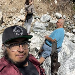
Yes yes and yes. I came here in a Friday with a friend and and some smoke fir photography. We where the only ones here that day. It was a cold February day and the drive from LA was long but worth it. Ok after you park your car walk the path about 200 ft and on your right you'll see some metal thin post, one of them is painted purple. Walk the path about a good 50 to 60 feet and you'll see the entrance with the stairs. Go down and go to the left. You'll hunch over walking through about 15 feet and you'll come into the main chamber. It's huge. It's a great place to just stare and wonder how and when this was created. We where alone so took some great shots with smoke, I suggest also when your done to just explore and walk some of the trails in the area. It's a geological wonder.

OMG. This is the most awesome thing I have ever done in my whole entire life. Seriously. Climbed around inside a lava tube. First - to get there. Look at the maps I posted. Or WAZE knows how to get you there. I tried to go 2 years ago, but couldn't get up the road since I didn't have AWD or high clearance on my rental. This year the road had been regraded and I'm pretty certain any 2WD could make it. Aiken Mine Road doesn't have a street sign. There is a white rock at the road. Once on Aiken Mine, there are a couple turn-offs. But just always pick the straightest Fork. The road kinda ends in a cul de sac parking lot. It's about a 1/4 mile walk from here. But if you do have AWD high clearance, you can continue on the road and get right up to within 200' of the tube. Our Infiniti QX60 was able to make it. Look for the rock cairn and the pink spray paint post. Walk the trail from here. Ignore the first hole in the ground and continue to the second hole. You can actually see the ladder sticking out of the second hole. Climb on down. Over to the right is a dead end. Climb down to the left. You will then see a tunnel about 3' tall. Climb through that. It's only that low for about 5'. And you can stand up straight again in about 10'. Then you are below the first hole. You are actually in a huge room. And you see the tube of light coming down from the small hole in the ground. It is such a surreal experience. I've been in a few caves. But this is different. If it was the 80's, I'd say it was tubular.

Amazing pretty much sums it up! A four wheel drive type of vehicle is highly recommended though our Mini Cooper did just fine as well. Prepare to go off roading for 10 miles round trip as you will need to drive your car in the dirt/sand and into the actual lave tube trail itself. Take it all in once you get there and stay for a long as you can, it is truly amazing.

Kelbaker Rd -- approx 20 miles Right on Aiken Mine Rd approx 5 miles Once reach sign "Lava Tube Trail" hike from here! Leave car. Go up short trail and make a right when you see trail heading uphill (red painted rod will indicate way) You will pass a hole 3 minutes into hike, skip that one and keep going until you come across another hole. This one will contain a ladder. Happy exploring :)

This place was pretty cool. There is the possibility of getting the hanta virus from going here, no joke, so try not to disturb the dust to much in the cave. There is a large chamber you have to crab walk to get into and it's the size of a large living room. The path that leads you to the mouth of the tube/cane is denoted by the world's smallest sign that doesn't aurally say anything. It's about 25 miles into the mojave to get here but it worth it. The off roading path was always pretty fun.

I can't believe I forgot to review this crazy adventure from a couple years ago. I have visited the lava tubes in Hawaii and when I found out we had one in the middle of the desert I knew I would have to come check it out. Post pandemic, my husband and I set out on a Saturday morning to find and explore these tubes. From Las Vegas it takes roughly 2.5 hours to get there. Driving the I15 freeway, take the Kelso Road exit and make a left turn. Drive on this road till you see Aiken Mine Road. Turn here and it will take you to the tubes. Be advised this is a dirt road not maintained so it can be a challenge for a regular vehicle. High clearance vehicles are preferred. Once you arrive and park, you will see the trail that takes you to a ladder that you will climb down to enter the tube. Be careful and watch your head as you descend into the lava tube. It is very easy to hit your head on the overhead rock hanging down. If you hit the tube at just the right time, light will filter through and it's very interesting and unique. Be careful with the dust down there, it is swirling all around from foot traffic. I advise wearing a mask like I did in order to not breathe in bad air. Although not as picturesque as the Hawaiian tubes, it was a fun little adventure to seek out. Remember to follow the principles and Leave No Trace. read more


High clearance vehicles prefer due to dirt road travel 4.5 mile from the pave road. With high clearance vehicle, you can park close to the entrance. If not you will need to hike 1/2 miles to the entrance. The entrance is on the hill. There is a staircase to decent to the bottom of the tube. There is lava rock surrounded this area. Best time to visit is 10:30 to 1:30. The light is shine straight down. The trail is rock a bit. May need a small flash light to guide your path. The sun beam is beautiful. Love the natural hole create this wonder. It is part of Mojave Desert must see item. Please remember there is not much of cell signal in this area. Paper map of early study the route is good to prepare ahead. read more


Definitely one of the weirder adventures I've embarked upon - and undoubtedly one of the most fun!! What a trip haha! Finally made it out here - been trying since the #localadventurechallenge put it on my radar last September but it was closed due to Covid I think (or a fire - can't remember lol). You'll drive waaaay out into the Mojave Desert, passing tons of gnarly Joshua Trees - and then spend another 40+ minutes driving down an insanely bumpy, rocky, sandy road. Then you'll finally see the little roundabout parking area with a sign for the tubes - get out and hike a tiny bit - I'd say about 1/2 a mile - unless you're like us and take the wrong trail lol - hiking past all these rocky lava rock explosions! Black and red and so rough and pointy - it's mind blowing how anything can grow outta this stuff! And then you'll finally stumble upon a gaping hole opening up into the desert floor with stairs leading down. At the bottom you'll think you should go right but you actually want to go left - the opening on the right looks like it caved in as it's full of rocks and dirt - don't go that way! When you go left, you'll have to climb over large lava boulders and it gets super dark so have your cellphone light or a flashlight - you'll need it for sure! And then BAM!!! It suddenly gets light and opens up into the coolest chamber!! If you time it right, you'll catch beams of light shining in through lava holes in the roof of the cavern. We were there mid morning and there weren't any beams until we started to leave - around 1030am ish I think - a tiny beam finally appeared! I definitely want to go back to catch the full light beam effects someday - but phew that ride in sure is tough! That being said, I highly recommend a rental car - and an elevated one - Bc you're gonna be going over some serious bumps and even some large rocks along the road. It's only about 5 miles of the Hell Road but it takes a good solid 40 mins or more to drive it Bc of the conditions. And you'll also see a fork in the road on the way in - stay to the left!! Supposedly if you go to the right, the sand is really deep and you'll get stuck! To get here I used google maps - and I had downloaded the offline map - DO IT - Bc there's no signal out here whatsoever. But google maps recognized Mojave Lava Tube and got us here nonetheless. Apple Maps was all kinds of wrong lol. I also recommend hiking boots - you don't HAVE to have them - but the ground is incredibly rocky and hard to traverse- I had on my vans and it was so tough. Hiking boots would've been much more comfortable! Oh and there's absolutely NO cell signal out there for miles - so just be safe - maybe don't come alone - let somebody know where you're going etc. read more


1 year ago
This was an unique experience especially if there are any sunlight shining through the cave. Probably better if you have a high clearance car to drive 5 miles off-road to this location. From the parking, it was about a ~10 minute walk to the cave. After you climb down the stairs, head left to the opening with a flashlight. Then, crouch down to get through this small opening. The cave was smaller than I thought and can fill up fast with people looking to get photos! read more


It's a tiny cave in the middle of nowhere and almost risked getting stuck on the off-road path en route to here but it was worth it. It's quite easy to miss the entrance, but you have to go about 5 miles on a reallllllllllllllly bumpy road that before you make it to a roundabout. Download an offline version of Google Maps; no reception here. Park at the roundabout, then walk up the slight slope and go to your right and you'll see a ladder. You can go down from there and and you'll find the cave after going under a narrow gap. It's quite nice temperature-wise compared to the sweltering heat outside. You will have to walk down stairs, as well as hunch down to get in the cave, so it's NOT handicap friendly, for those that want to know. I want to reemphasize that my 2WD low riding car made it after going between 5-15 mph for almost 35 minutes, and only scratched it up once towards the last 200 feet after the cul de sac, which honestly was a mistake and I should've parked at the cul de sac then just walk the short distance to get to the tubes. It's also next to Kelso Dunes so I recommend visiting this place in addition to the caves if you're out in the Mojave here. read more


Is an extremely easy jaunt up a slight slope to a fixed metal ladder. If you lose sight of your vehicle for more than a minute you've gone too far. You pass the second corral and there will be a small cul-de-sac dirt loop to your right a bit down the road. Unless you have an authentic 4 x 4 I would not suggest trying to go up the embankment which is about 200 feet to the ladder. When I went it was a weekday and there was nobody there. The road in, is very bumpy, sometimes graded and towards the end of the road has some sharp lava rocks so go easy. You do not require a 4 x 4 however it is suggested. I went in a sedan and the 4.2 miles took me about 35 minutes to go down because I needed to go so slowly. Definitely bring yourself water. And a flashlight, a headlamp if you have one. You will need both hands to go down the latter there are about 7-9 rungs, it's not very steep. You will need to duck to get into the larger portion of the cave. So when you reach the bottom of the ladder, you can make a right or a left. I suggest left. The left will take you out into the main cave area. The right is just a small dead end. As I stated it is very dark in there until you reach the area of the main cavern where there are portals for light comes through. It is safe enough for children to traverse. However I suggest leaving fido home. The rocks are sharp and probably not paw friendly. If you come out here enjoy the views. When I was out here I ended up hiking in additional 12 miles into the Mojave. If you're out here, you will hear a strange, deep booming noise occasionally. It's coming from the military base. I believe Fort Irwin. Nothing to fear just random bombing practices. read more


This is a very easy .5 mile hike to a beautiful cave with 2 light entry points that photograph very well! Quick read: yes, go it's worth it. But please try to leave the smoke bombs and manmade items out of the area! Some tips: 1: get gas before you head out. There aren't many stations near by. Not many restaurants open right now either so bring food if you want. 2: bring a phone flashlight or a real one just for the few feet of darkness. 3. Turn left at the sign that says lava tubes- there is no arrow. 4. The 5 mile road up to the trailhead is not at bad. Go slower over the rocks and around 30 on the washboard portions. You can take a car/sedan and be just fine. 5. park at the lot and walk the .5 up- trying to drive up the trail(some Jeep's were) destroys the trail. 6. Not much else to do around here, but if you like dunes there are sand dunes about 20 minutes away from this to also do. Now go check it out yourself! read more


This is a pleasant natural area to check out when in the Mojave Nation Preserve. My photos are from 2006, the only time I've been here. Be aware that the map marker for this listing is not correct. Pay attention to the reviewers that tell you to go to Aiken Mine Road and then head north. The lava tube is west of Kelso, California, not east as this marker shows. When I visited, the road evidently was worse than it is today. While I didn't need my 4 wheel drive, the high clearance was necessary. It sounds like they've done some blading of the dirt road. As you follow the trail to the ladder, you bypass what's a natural hole where the lava hardened to the open air. Past this opening, you get to another one and here there's a ladder to go down to the floor of the lava tube. Since I've walked some long lava tubes in Hawaii, this was less impressive to me. But, this is in our area. How often to we get to fly off to Hawaii? One word of caution: avoid kicking up dust in caves in the southwest. Pack rats and mice make these places their home and they can carry the hantavirus. This is in their excrement and contact with it or from dust in the air can cause humans to be infected. Just keep the dust to a minimum and avoid exploring pack rat middens. read more


5 years ago
Cool little place to stop, but definitely not a spot you'll be spending a lot of time at unless you plan on hiking and exploring the surrounding area. My girls and I spent about 10 mins taking pics and we were done. Bring a flashlight or use your phone light as there is a dark spot where you can't see a thing and depending on your height, you may have to crawl. Once off the main road, you will be on a bumpy dirt road, which is still very doable by sedan. Bumps are small, but sounds/feels horrible! You will see 1 sign when you are near the Lava Tube. MAKE SURE YOU GO STRAIGHT/LEFT LANE. My Google Map/Yelp, told us to turn right and that was a huge mistake! We drove for a few more miles. Luckily I have an SUV, but low clearance sedans would probably not make it through the thick dirt/sand and/or boulders. We eventually had to stop because we got to a section that my SUV would definitely not make it through without causing damage or popping a tire. The road was narrow so I had to drive in reverse til I could find a spot to turn my car around. But if you have a 4x4 jeep/truck, it definitely looks like a fun challenge! Anyway, once you see the sign, the parking lot takes less than a minute to get to and the walk up to the ladder is about 2-3 mins. read more


Yes yes and yes. I came here in a Friday with a friend and and some smoke fir photography. We where the only ones here that day. It was a cold February day and the drive from LA was long but worth it. Ok after you park your car walk the path about 200 ft and on your right you'll see some metal thin post, one of them is painted purple. Walk the path about a good 50 to 60 feet and you'll see the entrance with the stairs. Go down and go to the left. You'll hunch over walking through about 15 feet and you'll come into the main chamber. It's huge. It's a great place to just stare and wonder how and when this was created. We where alone so took some great shots with smoke, I suggest also when your done to just explore and walk some of the trails in the area. It's a geological wonder. read more


8 years ago
OMG. This is the most awesome thing I have ever done in my whole entire life. Seriously. Climbed around inside a lava tube. First - to get there. Look at the maps I posted. Or WAZE knows how to get you there. I tried to go 2 years ago, but couldn't get up the road since I didn't have AWD or high clearance on my rental. This year the road had been regraded and I'm pretty certain any 2WD could make it. Aiken Mine Road doesn't have a street sign. There is a white rock at the road. Once on Aiken Mine, there are a couple turn-offs. But just always pick the straightest Fork. The road kinda ends in a cul de sac parking lot. It's about a 1/4 mile walk from here. But if you do have AWD high clearance, you can continue on the road and get right up to within 200' of the tube. Our Infiniti QX60 was able to make it. Look for the rock cairn and the pink spray paint post. Walk the trail from here. Ignore the first hole in the ground and continue to the second hole. You can actually see the ladder sticking out of the second hole. Climb on down. Over to the right is a dead end. Climb down to the left. You will then see a tunnel about 3' tall. Climb through that. It's only that low for about 5'. And you can stand up straight again in about 10'. Then you are below the first hole. You are actually in a huge room. And you see the tube of light coming down from the small hole in the ground. It is such a surreal experience. I've been in a few caves. But this is different. If it was the 80's, I'd say it was tubular. read more


9 years ago
Amazing pretty much sums it up! A four wheel drive type of vehicle is highly recommended though our Mini Cooper did just fine as well. Prepare to go off roading for 10 miles round trip as you will need to drive your car in the dirt/sand and into the actual lave tube trail itself. Take it all in once you get there and stay for a long as you can, it is truly amazing. read more

10 years ago
Kelbaker Rd -- approx 20 miles Right on Aiken Mine Rd approx 5 miles Once reach sign "Lava Tube Trail" hike from here! Leave car. Go up short trail and make a right when you see trail heading uphill (red painted rod will indicate way) You will pass a hole 3 minutes into hike, skip that one and keep going until you come across another hole. This one will contain a ladder. Happy exploring :) read more


 - Hiking Near Me - Baker, California")

8 years ago
This place was pretty cool. There is the possibility of getting the hanta virus from going here, no joke, so try not to disturb the dust to much in the cave. There is a large chamber you have to crab walk to get into and it's the size of a large living room. The path that leads you to the mouth of the tube/cane is denoted by the world's smallest sign that doesn't aurally say anything. It's about 25 miles into the mojave to get here but it worth it. The off roading path was always pretty fun. read more


9 years ago
Perfect place to get away for awhile and explore the many lava tubes of the Mojave Desert. This place has been here for millions of years, a reminder of the cataclysmic change that has been occurring on this planet. Honored to have been able to witness such a sight. One visit and your five senses are awakened by the remoteness and solitude. Great place to bring the family to include the little ones. read more


7 years ago
7 years ago
6 years ago
13 years ago
More info about Mojave Lava Tubes
Mojave National Preserve
Baker, CA 92309
Directions
Hours
Outdoor Amenities
Ask the Community - Mojave Lava Tubes
Review Highlights - Mojave Lava Tubes
You might also consider


Mojave Lava Tubes - hiking - Updated July 2026
Best of Baker
Browse Brands
Related Searches in Baker, CA
Best Dog Hiking Trails Around Baker, California
Best Fishing Locations and Guides in Baker, California
Best Fun Things to Do in Baker, California
Best Lookout Points to Visit in Baker, California
Best Nature Trails for Hiking in Baker, California
Best Sightseeing Experiences Available in Baker, California
Best Spots for Star Gazing in Baker, California
Best Waterfalls and Swimming Holes in Baker, California
Check Out Off Road Trails in Baker, California
Discover Dog Friendly Trails to Explore in Baker, California
Discover Popular Bike Trails in Baker, California
Discover a Hiking Trail in Baker, California
Discover the Best Night Hike Trails in Baker, California
Dog-Friendly Hikes With Dogs in Baker, California
Enjoy Off Leash Dog Hikes in Baker, California
Enjoy the Best Walking Trails in Baker, California
Explore Beautiful Parks and Green Spaces in Baker, California
Explore Easy Hikes Perfect for All in Baker, California
Explore Landmarks & Historical Buildings in Baker, California
Explore Popular Campgrounds Near Baker, California
Explore Popular RV Parks Around Baker, California
Explore Popular Scenic Overlook Points in Baker, California
Explore Top Dog Parks in Baker, California Near You
Explore the Best Swimming Holes Around Baker, California
Family Friendly Hiking With Kids in Baker, California
Find Beautiful Views in Baker, California
Find Parks and Recreation Activities in Baker, California
Find Top Dog Friendly Parks to Visit in Baker, California
Find Top-Rated Waterfalls in Baker, California Now
Find the Best Parks for Picnics in Baker, California
Find the Best Playgrounds to Visit in Baker, California
Must-See Tourist Attractions Around Baker, California
Off Leash Dog Hiking Trails in Baker, California
Plan a Scenic Drive Route Near Baker, California
Popular Kids Activities in Baker, California
Popular Picnic Spots to Visit in Baker, California
Popular Things to Do in Baker, California
Relax at Natural Hot Springs Near Baker, California
See Top Fireworks Events in Baker, California
Top Dog Friendly Things to Do in Baker, California
Top Hiking Trails to Explore in Baker, California
Top RV Campgrounds to Visit in Baker, California
Top Running Trails to Explore in Baker, California
Top Swimming Lakes to Enjoy in Baker, California
Top Things to Do With Kids in Baker, California
Top-Rated Camping Sites in Baker, California
People found Mojave Lava Tubes by searching for…
Things to Do in Baker, California
Campgrounds in Baker, California
Hiking Trails in Baker, California
Sand Dunes in Baker, California
Off Road Trails in Baker, California
Camping Sites in Baker, California
Abandoned Places in Baker, California
Photo Spots in Baker, California
Walking Trails in Baker, California
National Parks in Baker, California
Camping Cabins in Baker, California
Places to Visit in Baker, California
Parks for Kids in Baker, California
State Parks in Baker, California
Fun Places to Go in Baker, California
Great View Points in Baker, California