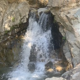
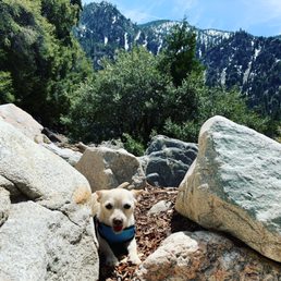
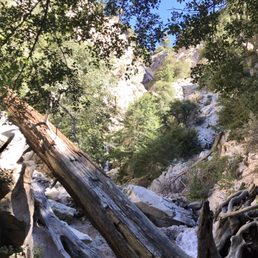
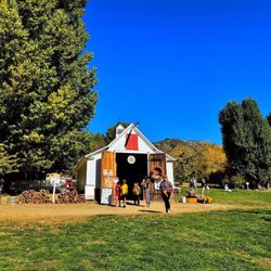
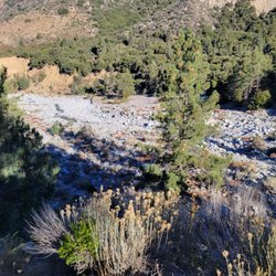
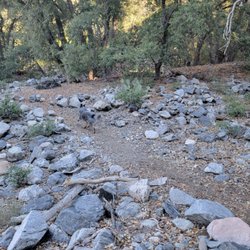
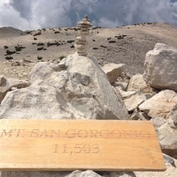
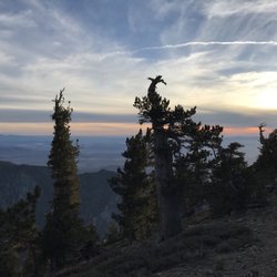
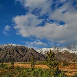
Big Falls Photos


You might also consider
More like Big Falls
Recommended Reviews - Big Falls
Start your review...

Reviews With Photos

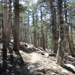
Amazing lil gem! Hikes for all experience levels! First off, it's in the mountains, so its gonna be a little chillier than Orange/LA/San Bernandino. Second, there is limited parking at the trail head, but its free with a national park pass! The trail is a little vague, but super easy to get to the bottom of the falls. Just meander across the little creek, and you're there. Its an intermediate difficulty to get to the waterfall lookout, and there is some bouldering to get to the base of the falls. It's a georgous view, with a few flat areas to hang out. There were a couple wading pools on the way up, but not very big/deep. So many fun picture spots with the plants, tree pirches and rocky areas. A couple warnings though: - the bathroom was pretty bad, not trashed, but smelt like a month old litter box - the pools are rocky, grab water shoes!

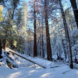
As a Nor Cal trail walker, this was one of the easiest for us to drive through. Not a lot of winding roads, nor narrow, nor cliff side roads. We didn't make it to the water Falls because the ground was snow packed and we were not the weather prepared. nor did we get to catch the glimps Of the waterfall that the Ranger advised us of before we headed back down the mountain. Definitely one of my top places to visit again when I'm back in southern Cal. For now I will enjoy my mountains in Northern California. Convenient, friendly, beautiful and a must!

I love this place. This used to be where I'd go by myself in high school and early college to get away from people. No reception, just you and the cooling waterfall. The hike is easy and starts off with a trail. It's a bit bumpy, so expect to climb rocks if you want to go up higher. Take your shoes off and dip your feet, but PLEASE DO NOT LITTER. How will you or others be able to return to this beauty if you don't take care of it? Throw away your trash! Why choose this place to leave diapers, beer cans, and water bottles??? Be responsible, man!

Four stars only because I think that the parking lot could be bigger for the weekend crowd. There are plenty of bbq grills in the shaded area for family and friends to enjoy. There was a sheriff overlooking the area. A $5 parking/day pass is usually needed, but it wasn't enforced yesterday (June 28, 2020). I'm not sure if it's covid or weekend related. I went yesterday with my family and friends. By 9am, the parking was already full. We tried to wait to see if some cars would leave, but we had no luck. We learned that you gotta be there extra early to reserve parking, otherwise you have to find a parking elsewhere, which on our case, 2-miles down the road past the store. Yes, we had to hike up more than 30 minutes to and from the parking lot. We planned to bbq at the site, but since we parked so far we had to go to Thurman Flats Picnic Area which is only about 10 mins from Big Falls. The hike is as long/challenging as you want it to be. There's a path that you can take to hike to the top of the falls. We only went to the base of the falls which only took about 5-10 minutes. Water is freezing yet clear. I recommend wearing water shoes when going to the falls. The rocks hurt! Also, there were only a few trashes that I saw and picked up some. Please be courteous by picking up your own trash! I love this place. It was crowded during the weekend, but we made sure we still practiced social distancing. I will be going again and next time, I'll be hiking all the way to the top!
Beautiful place, beautiful waterfalls but I hate how people come here to hang out and blast their crappy music. If people want to hang out and listen to music they should stay home and do that, or maybe they don't know that "head phones" exist?Believe me people out in nature don't want or don't care about your music so keep it turned off or in your ears only. Don't ruin nature by blasting music at this beautiful place or any hiking trail. I love nature and it's peacefulness but here is none of that thanks to some people who do not appreciate nature at all.

Beautiful area to go enjoy for a day hike. A short walk over rocks to get to the pools and see the waterfalls, anybody can do it kids, pets and even grandma. After that it you go over rocks, be careful. As of June 2019 there is plenty of water flowing. At the end of the road coming into the small town there is free parking on the gravel area or get a permit and park in the parking lot. There is public pit toilets.

A short 35 minute drive from me and a little gem waiting to be explored. Before heading in, stop at the local shop and pick up a Adventure pass for $5. This pass is required to park around the area, rather be safe then sorry. We BBQ and hung out around the picnic area before hiking. Last time we were here was in September and there was mini stream leading up the waterfall. Almost a year later and all that rain there is a nice stream of water now. The hike is not too bad, just take your time and watch your steps. It can be challenging to due the varies rocks being wet or smooth. Once you get to the waterfall it gets a little chilly, but worth the trip up there. I'm sad to see there are people littering this time on my visit. I picked up a couple of cans and bottles while hiking. If you see any trash, please pick up trash even though it might be yours. I notice a couple more graffiti on my second visit here. Overall a great spot to hike and see the waterfall. Spend the day and you'll enjoy it here.

Exciting and beautiful short hike to this fall. However, I did go pass the "danger" sign and hiked to the base of the waterfall and what a stunning treat. This is a dangerous hike which involves, maneuvering across boulders and crossing a flowing creek. I highly recommend hiking shoes or boots for this hike and experienced hikers only. The boulders are slippers and some unstable. Also, please do not take kids or pets beyond the warning sign. *WARNING* Do your research on parking before arriving. There were plenty of citations being issued. Enjoy the hike and always be smart, while exploring in nature. Thanks


Who knew this waterfall was a short drive away? I came here on a weekday morning and it wasn't busy at all. Bought an adventure pass at the town store but probably didn't need it. We could've parked for free at the gravel lot next to the paid parking area since no one else was here on a Thursday morning. The falls are just a short hike from the parking lot. It was so peaceful up there! There are other hiking trails around the area too. I'll have to come back again!


2 years ago
The drive up to this trail is not bad at all! I sometimes get scared of driving up high into the mountains but this was a pretty easy drive and there weren't any parts that I felt were scary. I was driving from Ontario, CA. You do need a pass to park in the lot. There are restrooms at the parking lot if you need to use them. The hike up is a pretty short one with pretty views! There are tons of shade from the trees and the water/waterfall was beautiful! read more


2 years ago
Beautiful day trip good hiking and cool water refreshing and fun for everyone but please when going take out anything you bring in read more


I had a great safe visit. I paid the $5 Forest Adventure pass at Elkhorn General store on Valley of the Falls Dr, a 1.2 mi from the Big Falls Trailhead and Picnic area. I had a great time hiking with my senior father in law, and my family. The water was refreshing. The parking looks great this spring. This water flows into Hunington Beach, the sea, the Santa Ana River Wash. It was 52 degrees on group our walk through the creek and Cross the wash. Our walk was cut short by other hikers falling in the creek. Big falls trail will lead you along the river bed to cross the creek to a path of a waterfall overlook. The ice cold water was coming from the area of the mountainside has snow melting as we warm up this Spring season. The creek felt refreshing this morning, I dampened my On Running shoes with waterproof silicone in the waters by crossing the creek on a fallen branch. I refreshed my sun beaten hair with the ice melt waters. I like this trailhead. For years Water from San Bernardino mountains has collected in way of steel pipes that flow by gravity on the steep mountainside above a creek pumped in tunnels to Water Companies piped downhill to be bottled and sold as Arowhead Spring Mountain Water. read more


1 year ago
4 years ago
Amazing lil gem! Hikes for all experience levels! First off, it's in the mountains, so its gonna be a little chillier than Orange/LA/San Bernandino. Second, there is limited parking at the trail head, but its free with a national park pass! The trail is a little vague, but super easy to get to the bottom of the falls. Just meander across the little creek, and you're there. Its an intermediate difficulty to get to the waterfall lookout, and there is some bouldering to get to the base of the falls. It's a georgous view, with a few flat areas to hang out. There were a couple wading pools on the way up, but not very big/deep. So many fun picture spots with the plants, tree pirches and rocky areas. A couple warnings though: - the bathroom was pretty bad, not trashed, but smelt like a month old litter box - the pools are rocky, grab water shoes! read more


3 years ago
As a Nor Cal trail walker, this was one of the easiest for us to drive through. Not a lot of winding roads, nor narrow, nor cliff side roads. We didn't make it to the water Falls because the ground was snow packed and we were not the weather prepared. nor did we get to catch the glimps Of the waterfall that the Ranger advised us of before we headed back down the mountain. Definitely one of my top places to visit again when I'm back in southern Cal. For now I will enjoy my mountains in Northern California. Convenient, friendly, beautiful and a must! read more


I love this place. This used to be where I'd go by myself in high school and early college to get away from people. No reception, just you and the cooling waterfall. The hike is easy and starts off with a trail. It's a bit bumpy, so expect to climb rocks if you want to go up higher. Take your shoes off and dip your feet, but PLEASE DO NOT LITTER. How will you or others be able to return to this beauty if you don't take care of it? Throw away your trash! Why choose this place to leave diapers, beer cans, and water bottles??? Be responsible, man! read more


6 years ago
Four stars only because I think that the parking lot could be bigger for the weekend crowd. There are plenty of bbq grills in the shaded area for family and friends to enjoy. There was a sheriff overlooking the area. A $5 parking/day pass is usually needed, but it wasn't enforced yesterday (June 28, 2020). I'm not sure if it's covid or weekend related. I went yesterday with my family and friends. By 9am, the parking was already full. We tried to wait to see if some cars would leave, but we had no luck. We learned that you gotta be there extra early to reserve parking, otherwise you have to find a parking elsewhere, which on our case, 2-miles down the road past the store. Yes, we had to hike up more than 30 minutes to and from the parking lot. We planned to bbq at the site, but since we parked so far we had to go to Thurman Flats Picnic Area which is only about 10 mins from Big Falls. The hike is as long/challenging as you want it to be. There's a path that you can take to hike to the top of the falls. We only went to the base of the falls which only took about 5-10 minutes. Water is freezing yet clear. I recommend wearing water shoes when going to the falls. The rocks hurt! Also, there were only a few trashes that I saw and picked up some. Please be courteous by picking up your own trash! I love this place. It was crowded during the weekend, but we made sure we still practiced social distancing. I will be going again and next time, I'll be hiking all the way to the top! read more


6 years ago
Beautiful place, beautiful waterfalls but I hate how people come here to hang out and blast their crappy music. If people want to hang out and listen to music they should stay home and do that, or maybe they don't know that "head phones" exist?Believe me people out in nature don't want or don't care about your music so keep it turned off or in your ears only. Don't ruin nature by blasting music at this beautiful place or any hiking trail. I love nature and it's peacefulness but here is none of that thanks to some people who do not appreciate nature at all. read more

Beautiful area to go enjoy for a day hike. A short walk over rocks to get to the pools and see the waterfalls, anybody can do it kids, pets and even grandma. After that it you go over rocks, be careful. As of June 2019 there is plenty of water flowing. At the end of the road coming into the small town there is free parking on the gravel area or get a permit and park in the parking lot. There is public pit toilets. read more


7 years ago
A short 35 minute drive from me and a little gem waiting to be explored. Before heading in, stop at the local shop and pick up a Adventure pass for $5. This pass is required to park around the area, rather be safe then sorry. We BBQ and hung out around the picnic area before hiking. Last time we were here was in September and there was mini stream leading up the waterfall. Almost a year later and all that rain there is a nice stream of water now. The hike is not too bad, just take your time and watch your steps. It can be challenging to due the varies rocks being wet or smooth. Once you get to the waterfall it gets a little chilly, but worth the trip up there. I'm sad to see there are people littering this time on my visit. I picked up a couple of cans and bottles while hiking. If you see any trash, please pick up trash even though it might be yours. I notice a couple more graffiti on my second visit here. Overall a great spot to hike and see the waterfall. Spend the day and you'll enjoy it here. read more


6 years ago
7 years ago
This hike is actually pretty fun but rough with all of the rocks and a lot of the dirt trail was washed away because of the recent rain, so wear good shoes. Views are beautiful... read more


7 years ago
Exciting and beautiful short hike to this fall. However, I did go pass the "danger" sign and hiked to the base of the waterfall and what a stunning treat. This is a dangerous hike which involves, maneuvering across boulders and crossing a flowing creek. I highly recommend hiking shoes or boots for this hike and experienced hikers only. The boulders are slippers and some unstable. Also, please do not take kids or pets beyond the warning sign. *WARNING* Do your research on parking before arriving. There were plenty of citations being issued. Enjoy the hike and always be smart, while exploring in nature. Thanks read more


7 years ago
It's the best I fell in love with this place It just brought me back to life! And want to thank Cindy and misty! Now I'll take my whole family, and thank you god for all your beauty read more


6 years ago
This forest is outstanding!!!!! It's a wonderful place to hike, picnic, relax, and enjoy the scenery. There are trees galore, and beautiful streams all around. There are even gorgeous waterfalls!!! Be careful because we did see a bear and a snake while hiking. read more


8 years ago
Who knew this waterfall was a short drive away? I came here on a weekday morning and it wasn't busy at all. Bought an adventure pass at the town store but probably didn't need it. We could've parked for free at the gravel lot next to the paid parking area since no one else was here on a Thursday morning. The falls are just a short hike from the parking lot. It was so peaceful up there! There are other hiking trails around the area too. I'll have to come back again! read more


6 years ago
A very fun easy 5 -10 min walk from the parking lot. You don't necessarily get wet unless you decide to hike up to the highest points of the waterfall. Very easy trail even for small children. Just be careful as always, rocks can be very slippery. read more


9 years ago
I fell in love with this little trail. I plan to come back when I'm not 8 months pregnant. The drive from LA is about 2 hours & not difficult. The drive is flat land so no major incline up into the mountains or windy roads which was great for once. Especially to an epic waterfall. The actual trail is about 30 minutes from Redlands, Ca. As you leave Redlands & head into the Forest Falls community it's just absolutely beautiful. The drive is quite amazing through their little town. I felt completely out of place so we didn't really stop anywhere, but next time we come back we plan to explore a lot more & try to educate ourselves on the surroundings, maybe pick up some fruit at all the fruit stands/stores & inquire about the campgrounds. Once you pass the town, you can't miss the parking because the road ends. The bathroom facility is located right in front of the parking lot. Signs are displayed everywhere informing you that you need an adventure pass to park, then there is a separate gravel parking lot where a fee is not required. I'm sure when it's busy it can fill up very quick. If you need an adventure pass, there is a general store that sells them & a ranger station as well. The hike itself is along a lot of boulders but beautiful from start to end. I didn't make it to the base of the falls because I'm almost 9 months pregnant & the flies were unforgiving but if I was physically able it really wouldn't be any big deal. There is an incline going upwards which I wasn't aware of so just make sure you have some good hiking shoes & water to stay hydrated. It's a very short hike from what I researched & the surroundings are absolutely beautiful. I really cannot wait to come back here. I know it's one of the shortest hikes in the area but the landscape & general area of this makes this 5 stars plus for me. From videos & pictures I've seen, it doesn't appear to get too crowded. Although it is beautiful, it is a far drive for people from LA or coastal areas & I am sure people from around San Bernardino go to other epic hikes but for me coming here for the first time was pretty magical. It even rained on us when we left & that was the highlight of it all since it was over 100 degrees back in LA. read more


The hike itself isn't very long, it was about a mile. It's kind of steep if you want to be directly next to the waterfall. You have to do some rock climbing and there were quite a bit of people despite it being a weekday. read more


3 years ago
3 years ago
7 years ago
This is my favorite place to come now. Soooo beautiful and peaceful. It's very clean. Has a nice area to picnic. Parking is free. And they have clean restrooms. read more

12 years ago
Don't get me wrong the falls are GORGEOUS! The reason I only gave 3 stars is because I expecting there to be more of a hike to get to these beautiful falls, but there is no hike at all just a short walk FROM THE PARKING LOT to the bottom of the falls. Another reason I have taken off stars is because of the amount of people that were there. I can see this turning into something like Sapphire Falls in Rancho where people just abuse this beautiful area with trash and graffiti. If you are looking to visit beautiful falls this is a good place but there's not much of a hike PLEASE ENJOY DON'T DESTROY read more


WARNING: Disappointment and regret is all your gonna feel if you come this way! How can you come see one of the biggest water fall that is closed to the public, and make it a theme attraction? Yeah stand 200 feet away and try to zoom in from your camera phone or camera. If your brave to take the risk and go beyond the caution sign be careful not to get caught cause $5,000 or $10,000 penalty fine or jail is awaiting for you from the cops down below. Honestly not worth the risk at all. Well if you decide to make the drive anyways, it is a 2 hour drive coming from the LA or OC area, make sure you use gps prior because you will lose signal. If not follow the road all the way until you hit a bend that either you go left or right, keep to the right all the way till the end and it'll lead you there. You will have to give $5 to the main entrance for a pass or try a store around the area. There will be two trail path when you get to the destination, look to your left when you get out your vehicle. To the small water falls should be a 10 to 15 min hike only. All in all until restricted signs are down, this place is a miss in my book. read more


This place is so beautiful! I can't believe this hike isn't more known? Or maybe it is? The scenery was amazingly beautiful. The hike is a bit rocky and you will be climbing through rocks. We did trespass and go beyond the closed area sign and went all the way to the top. It was worth it! Just be careful. Apparently the rocks are wet, and people fell and died. Just take your time. The hike starts all the way at the end of the road and there plenty of parking if you are there around 8am. There's even a sign that says waterfall trail. An adventure pass is needed. There is a store that sells it on the way. Make sure you check what the weather is. It was 40 degrees the day I went. I also just started to step in the water and my feet were purple at the end! Bring some extra shoes and socks and dress for the weather. read more


11 years ago
Pretty easy hike! Paid only 6.78 for an Adventures Pass at a near by General store. Got there around 9:20am. Perfect timing! Had the entire place to ourselves! It's kind of steep but not very difficult. You just have to watch where you're stepping and pay close attention to the trail. Overall, it's worth a hike! *people just need to pick up after themselves* read more
 - Hiking Near Me - Forest Falls, California")


7 years ago
A gorgeous short hike just a short drive from Redlands. There is plenty of parking, and you can get a day or yearly pass for a good price. This would be a good hike for kids because it is easy and has a beautiful waterfall at the end! The hike was not even a mile and has plenty of spots to set up hammocks. It gets cold even in the summer, and snowed today before we got there. When we went it wasn't too crowded and it was quiet and serene. I recommend wearing sneakers or boots because you rock over walks for a bit before you get to the beginning of the trail. I enjoyed the hike and will definitely do it again! read more

First time here for me and my friends. Day pass is $5.00. The scenery is really nice. My 1st waterfall hike ever..I wasn't feeling well during the walk but the scenery and beauty make up for it. Good for beginners. .intermediate and advanced walkers. PS: try wearing jeans that you don't mind getting torned up...hiking shoes and not running shoes..a jacket because it's hellah cold..the water and the mist..water and snacks if you get hungry or thirsty. I learned my lesson with running shoes...work out yoga pants resulting into bruises and stepping into the cold water. Brrr !! PS: I wouldn't recommend the porta potties :/ but anyways. .check this place out. A get away from reality... read more


7 years ago
11 years ago
The trail above the "lookout" closed. From 10/8/2015 to 10/7/1016 due to "Public Safety" Such a shame. The valley is still a really nice place to hang out with many waterfalls before the restricted area. read more


10 years ago
Great hike, easy to get to and not very challenging! It will make you want more :) bring the norm a can of off wouldn't hurt sun block is a must. Shoes: I would at least wear a pear of rugged shoes, I'm a boot guy so yeah. Pretty cool to take a lunch up and eat it at the falls, it just mite surprise you :) coupled with forest falls is a really cool mountain feel 12 Miles from Redlands :) cheers ! read more
 - Hiking Near Me - Forest Falls, California")


8 years ago
Make sure you get the adventure pass to park there. Short hike to the waterfall, which is awesome! Was my husbands idea to check this place out on our way home from big bear. Totally recommend it. Only thing I didn't like was that some idiot thought it was cool to tag on some trees and a rock. Other than that place is beautiful, when we were there it wasn't too crowded. There was several people there but still nice and quiet enough to enjoy nature. When we were leaving parking lot was getting kind of full, so going early seems to be the time to enjoy this place. Bathrooms, not the best. Make sure you have hand sanitizer, they don't have sinks. read more

Not much of a hike here but the falls is gorgeous!!! I recommend wearing water shoes/hiking shoes with grip because there is a lot of boulders to climb over. For parking there are two lots, there is a limited amount of parking in the free lot, but keep an eye out for it before you decide to pay for parking. From the parking lot, you'll stroll for about 10 minutes or so until you reach the falls. The park is open from 6am-10pm. I definitely want to check it out during the winter time when there's snow! read more


9 years ago
6 years ago
Page 1 of 2
More info about Big Falls
Valley Of The Falls Dr
Forest Falls, CA 92339
Directions
(909) 382-2882
Call Now
Visit Website
https://www.fs.usda.gov/recarea/sbnf/recreation/hiking/recarea/?recid=26557&actid=50
Hours
Indoor Amenities
Outdoor Amenities
Other Amenities
From the Business
Ask the Community - Big Falls
Is big falls trail open?
This area is closed due to the El Dorado Fire. The Forest Order can be seen here: https://www.fs.usda.gov/detail/sbnf/home/?cid=fseprd822962
Is the waterfall open to the public? Need to do some Geology homework.
As of 8/1/2020 - All trails in the San Gorgonio Wilderness have been closed due to the #AppleFire. Additionally Big Falls Trail, Big Falls Picnic Area & the PCT between the Forest Boundary and Onyx Summit are closed.
Is the big falls trail open as of August 2020? Is it open during covid 19?
8/1/2020 - All trails in the San Gorgonio Wilderness have been closed due to the #AppleFire. Additionally Big Falls Trail, Big Falls Picnic Area & the PCT between the Forest Boundary and Onyx Summit are closed.
Can RVs park there?
This is a Day Use ONLY area. The road going into and spaces are very narrow without much room for maneuvering. With that said there is no restriction on having a small RV in the Picnic Area.
How long is the hike to the falls?
Big Falls Trail 1E13 is a 0.7 mile heavily trafficked out and back. A Recreation Pass is Required. (Adventure Passes or Interagency Passes accepted.)… Read more
Has anyone gone during this time of COVID? & is there a cost to get in?
Yes, it's currently open to the public & you need a Daily Adventure Pass ($5) but, Big Falls is NOT the Place to Be This Weekend! People all over Southern California looking… Read more
Driving up to the falls, is it narrow or winding? If a person has a phobia of closed in spaces, might driving up there be traumatic?
The road is a lot more straight coming up here and there are no steep drop offs along the road-I have the same phobia and drive up here just fine. The only closed spaces are where the trees cover the road and there's sunlight through them.
Review Highlights - Big Falls
You might also consider


Why does Yelp recommend reviews?
6 reviews that are not currently recommended
The reviews below are not factored into the business's overall star rating.
11 years ago
11 months ago
3 years ago
8 years ago
9 years ago
11 years ago
Big Falls - hiking - Updated June 2026
Best of Forest Falls
People found Big Falls by searching for…
Hiking Trails With Waterfalls in Forest Falls, California
Beaches in Forest Falls, California
Things to Do in Forest Falls, California
River Swimming in Forest Falls, California
Parks in Forest Falls, California
Attractions in Forest Falls, California
Scenic Drive in Forest Falls, California
Places to Take Pictures in Forest Falls, California
Scenic View in Forest Falls, California
Off Road Trails in Forest Falls, California
Dog Friendly Hiking Trails in Forest Falls, California
Natural Hot Springs in Forest Falls, California
Picnic Areas in Forest Falls, California
Waterfalls and Swimming Holes in Forest Falls, California
Scenic Overlook in Forest Falls, California
Free Snow Play in Forest Falls, California
Parks for Kids in Forest Falls, California
Walking Trails in Forest Falls, California
Dog Friendly Beaches in Forest Falls, California
National Parks in Forest Falls, California
Redwood Trees in Forest Falls, California
River in Forest Falls, California
People who viewed Big Falls also viewed
Oakmont Park
9 reviews
Zanja Peak Trail Head
8 reviews
Wildwood Canyon State Park
10 reviews
San Gorgonio via Vivian Creek
54 reviews
El Dorado Ranch Park
6 reviews
Blue Mountain Trail
21 reviews
San Timoteo Nature Sanctuary
13 reviews
Natural Parkland Trail Head
6 reviews
Bogart Regional Park
11 reviews
Massacre Canyon
8 reviews