
Zanja Peak Trail Head Photos


You might also consider
More like Zanja Peak Trail Head
Recommended Reviews - Zanja Peak Trail Head
Start your review...

Reviews With Photos

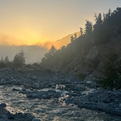
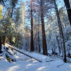
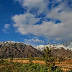
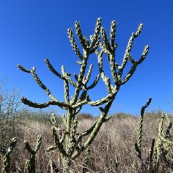
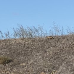
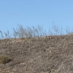
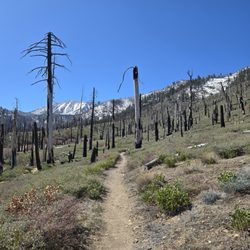
Zanja Peak Trail,located in the beautiful community of Yucaipa,California is a great collection of flower and tree covered trails that offers short easy hikes to longer more energetic hikes as well. The trail head offers free parking and leads you to the well marked trail head. Mountain bikes,trail running and dogs on a leash are welcome and at this time of year the flowers,shrubs and trees are blooming and quite stunning,especially with the snow covered peaks of San Bernardino peak on the background! Fresh lavender,sage,eucalyptus,ground flowers and more offer great picture taking opportunities for you and your family. To bag Zanja peak is 3543 feet high and will take about 1 hour to the top and at the top are spectacular 360 degree views of the surrounding area. Bring some good athletic,tennis,hiking,or trail shoes,a sweat shirt or lite sweater,a small bottle of water,a snack or picnic lunch and sit at the top and enjoy the beauty. From Zanja peak you can see San Bernardino peak due east, Mount San Jacinto due south east and Mount Baden Powell towards the west. . . . . #zanjapeaktrail #zanjapeak #yucaipa #ilovespring #iloveyucaipa #gohiking #hikingyucaipa #sanbernardinopeak #mtsanjacinto #mtbadenpowell #behealthy #hiking #ilovehiking #californiadreaming #californiadreamin #easyday #trailsofcalifornia #easytrails #bringacamera #scenicplaces #waynesalvatti #trailrunning #backpacking

Zanja Peak Trail Head is easily a five star hiking/biking location. I was expecting it to be an easy hike, but man was I wrong. I hike here and there, but for zanja I had to take a few breaks on the way up. This location offers many routes and it all depends on your skills. It is most inclines with very few declines. Signs and easy to follow dirt routes will guide you all the way up and down. Worth of advice, bring some water, snacks and some hiking shoes. There is no problem using running shows, but hiking boots make it easier. The Zanja trails are located in a good area near nice neighborhoods, but I did see a few transients. Dirt parking is available at the entrance and cell reception works just fine. The scenery is totally worth the challenge. read more


2 years ago
Great hike, lots of different paths to take. Definitely be cautious of mountain bikers as they tend to haul ass down, but are polite and courteous. Some steep inclines but nothing too bad or dangerous. Some shade when you're about half wayish. Definitely go early morning or evening in summer. Nothing but friendly people, and a good time! Plenty of parking in the trail lots, and there are business close by if needing restrooms. read more


4 years ago
Nice hike, u can choose if you want a difficult or moderate hike. No peak sign at the summit, though I bring my own sign yet i don't want to leave it there coz someone might took it or throw it away. I'll comeback for a sunrise hike. Free parking and not so much car the day that I went. read more
6 years ago
Zanja Peak Trail,located in the beautiful community of Yucaipa,California is a great collection of flower and tree covered trails that offers short easy hikes to longer more energetic hikes as well. The trail head offers free parking and leads you to the well marked trail head. Mountain bikes,trail running and dogs on a leash are welcome and at this time of year the flowers,shrubs and trees are blooming and quite stunning,especially with the snow covered peaks of San Bernardino peak on the background! Fresh lavender,sage,eucalyptus,ground flowers and more offer great picture taking opportunities for you and your family. To bag Zanja peak is 3543 feet high and will take about 1 hour to the top and at the top are spectacular 360 degree views of the surrounding area. Bring some good athletic,tennis,hiking,or trail shoes,a sweat shirt or lite sweater,a small bottle of water,a snack or picnic lunch and sit at the top and enjoy the beauty. From Zanja peak you can see San Bernardino peak due east, Mount San Jacinto due south east and Mount Baden Powell towards the west. . . . . #zanjapeaktrail #zanjapeak #yucaipa #ilovespring #iloveyucaipa #gohiking #hikingyucaipa #sanbernardinopeak #mtsanjacinto #mtbadenpowell #behealthy #hiking #ilovehiking #californiadreaming #californiadreamin #easyday #trailsofcalifornia #easytrails #bringacamera #scenicplaces #waynesalvatti #trailrunning #backpacking read more


7 years ago
We hiked this yesterday, March 25. There are two paths to the peak since it's a loop trail. The one we took up is difficult and steep without shade. The one we took down is gradual and very shady. Like other reviews, it seems to never end because once you think you are at the peak, there is another hill. At the peak, there are two benches and what seems to be a flagpole. It also seems to have about 5 different trails leading up to the top from many different locations. On the way down the were such beautiful flowers blooming. This was a great trail and an even better workout. For one person I would recommend at least 1 liter of water. I used my Apple Watch and it mapped out to be 4.8 miles and took us a little over two hours with a break at the peak. read more


13 years ago
More info about Zanja Peak Trail Head
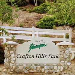
34300 Oak Glen Rd
Yucaipa, CA 92399
Directions
Hours
Outdoor Amenities
Ask the Community - Zanja Peak Trail Head
You might also consider


Why does Yelp recommend reviews?
1 review that is not currently recommended
The reviews below are not factored into the business's overall star rating.
9 years ago
Zanja Peak Trail Head - hiking - Updated July 2026
Best of Yucaipa
People found Zanja Peak Trail Head by searching for…
Trending Searches in Yucaipa, CA
Blueberry Picking near Zanja Peak Trail Head
Cliff Jumping near Zanja Peak Trail Head
Day Trips near Zanja Peak Trail Head
Dog Friendly Beaches near Zanja Peak Trail Head
Jet Ski Rental near Zanja Peak Trail Head
Kayak Rental near Zanja Peak Trail Head
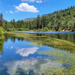
Lakes & Ponds near Zanja Peak Trail Head
Off Road Trails near Zanja Peak Trail Head
Outdoor Activities near Zanja Peak Trail Head
Peach Picking near Zanja Peak Trail Head
Places To Swim near Zanja Peak Trail Head
Places To Walk Around near Zanja Peak Trail Head
Pokemon Go near Zanja Peak Trail Head
Pool Day Pass near Zanja Peak Trail Head
Public Shower near Zanja Peak Trail Head
River Swimming near Zanja Peak Trail Head
River Tubing near Zanja Peak Trail Head
Rock Quarry near Zanja Peak Trail Head
Scenic Night View near Zanja Peak Trail Head
Scenic Overlook near Zanja Peak Trail Head
Secluded Spots near Zanja Peak Trail Head
Soccer Store near Zanja Peak Trail Head
Sunrise View near Zanja Peak Trail Head
Swimming Holes near Zanja Peak Trail Head
Swimming Lakes near Zanja Peak Trail Head
U Pick Farms near Zanja Peak Trail Head
Browse Articles
Browse Nearby
BEST of Yucaipa, California Coffee near Zanja Peak Trail Head
BEST of Yucaipa, California Restaurants near Zanja Peak Trail Head
BEST of Yucaipa, California Things to Do near Zanja Peak Trail Head
BEST of Yucaipa, California Breakfast near Zanja Peak Trail Head
BEST of Yucaipa, California Walking Trails near Zanja Peak Trail Head
BEST of Yucaipa, California Parks near Zanja Peak Trail Head
BEST of Yucaipa, California Campgrounds near Zanja Peak Trail Head
BEST of Yucaipa, California Day Trips near Zanja Peak Trail Head
BEST of Yucaipa, California Sledding near Zanja Peak Trail Head
Browse Brands
Related Searches in Yucaipa, CA
Best Dog Hiking Trails Around Yucaipa, California
Best Fishing Locations and Guides in Yucaipa, California
Best Nature Trails for Hiking in Yucaipa, California
Best Places for Horseback Riding in Yucaipa, California
Best Waterfalls and Swimming Holes in Yucaipa, California
Check Out Off Road Trails in Yucaipa, California
Discover Dog Friendly Trails to Explore in Yucaipa, California
Discover Easy Hiking Trails Near Yucaipa, California
Discover Kid Friendly Hiking Trails in Yucaipa, California
Discover Popular Bike Trails in Yucaipa, California
Discover Scenic Mountain Bike Trails Near Yucaipa, California
Discover Walking Parks in Yucaipa, California Near You
Discover a Hiking Trail in Yucaipa, California
Discover the Best Night Hike Trails in Yucaipa, California
Enjoy Camping Adventures Around Yucaipa, California
Enjoy Kayaking Adventures in Yucaipa, California
Enjoy Off Leash Dog Hikes in Yucaipa, California
Enjoy Scenic Places to Walk in Yucaipa, California
Enjoy Tent Camping Spots Around Yucaipa, California
Enjoy a Beautiful Waterfall Hike in Yucaipa, California
Enjoy the Best Picnic Spots and Ideas in Yucaipa, California
Enjoy the Best Walking Path in Yucaipa, California
Enjoy the Best Walking Trails in Yucaipa, California
Explore Beautiful Parks and Green Spaces in Yucaipa, California
Explore Easy Hikes Perfect for All in Yucaipa, California
Explore Fun Activities to Do in Yucaipa, California
Explore Picnic Parks Near Yucaipa, California
Explore Popular Campgrounds Near Yucaipa, California
Explore Top Dog Parks in Yucaipa, California Near You
Explore the Best Swimming Holes Around Yucaipa, California
Family Friendly Hiking With Kids in Yucaipa, California
Find Top Dog Friendly Parks to Visit in Yucaipa, California
Find Top-Rated Waterfalls in Yucaipa, California Now
Find the Best Parks for Picnics in Yucaipa, California
Hiking Trails With Waterfalls in Yucaipa, California
Off Leash Dog Hiking Trails in Yucaipa, California
Popular Outdoor Activities to Try in Yucaipa, California
Popular Picnic Spots to Visit in Yucaipa, California
Popular Waterfall Hiking Trails in Yucaipa, California
Safe River Swimming Areas in Yucaipa, California
Safe and Fun Parks for Kids in Yucaipa, California
Top Hiking Trails to Explore in Yucaipa, California
Top Playgrounds for Kids to Enjoy in Yucaipa, California
Top Running Trails to Explore in Yucaipa, California
Top Swimming Lakes to Enjoy in Yucaipa, California
Top Swimming Spots and Pools in Yucaipa, California
Top-Rated Camping Sites in Yucaipa, California
People who viewed Zanja Peak Trail Head also viewed
Carriage Trail
2 reviews
San Gorgonio South Fork Trail
3 reviews
Momyer Creek Trail to San Bernardino East Peak
6 reviews
Hulda Crooks Park
56 reviews
Big Falls
78 reviews
San Gorgonio Peak via Fish Creek
10 reviews
San Gorgonio 9 Peaks Challenge
2 reviews
Oak Glen Preserve and Southern California Montane Botanic Garden
63 reviews
Box Springs Mountain Reserve
60 reviews
John Tooker Civil Park
3 reviews