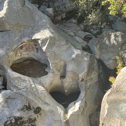
Heart Rock Photos


You might also consider
More like Heart Rock
Recommended Reviews - Heart Rock
Start your review...

Reviews With Photos

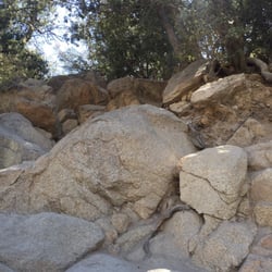
I ended up on this fun trail because it's next to camp seely (where they filmed parent trap), but to my surprise it led me to a fun heart rock! I thought i was getting lost a few times but whenever I thought that I found some very kind graffiti telling me where to go lol. Takes an hour total maybe? Very fun would recommend!


A beautiful hike! Close to lake arrowhead, they're known for the big heart shaped shaving on a rock. I'm really glad I did this hike because this was screaming fall. Yellow leaves, acorns, chilly weather, dry leaves on the ground. Plenty of streams you walk by as well. To get to the heart rock it only took maybe an hour. Then you just come back the same route. Where you start the trail you need to refer to a map because there was no signage of the trailhead. It was 0.4 miles from the parking area where it starts. My family and boyfriend all loved it!

This is an easy hike for anyone who is active. If you are sedentary, like most Americans- then this hike could be challenging. Especially if you live down the mountain and are not used to the altitude change. I am out of shape and barely exercise (I know I need to work on this). So, this hike was hard for me. And other people were struggling on the way back. There are hills on the way back, so prepare for that! My boyfriend who is very active, did not have an issue. It was a breeze for him. But he runs daily and is very active. But I would say for most people, this might be a little challenging. My dad brought cans of oxygen just in case and those really did help with the altitude sickness. I strongly recommend those oxygen cans! Life savers lol The trail is rocky and uneven at certain parts. You can slip if you are not careful. But for the most part, it is flat and do-able. There's lots of places to sit on big rocks and take breaks.

Loved this trail!! It's a fairly easy trail. It is family and pet friendly and a great hike to go on with little ones. A little more challenging for a toddler as I took my 3 year old and he was struggling at some parts especially towards the end. Overall we had so much fun. I loved seeing the water and the heart rock!


What's up: I wanted to go on a hike and I've had this particular one on my list for a while. It's a bit out of my way but I wanted to see what the heart was all about. We decided to go for it one Friday morning! Parking: No designated parking area. You pretty much park on the west side of the road of CA-138. There's a large dirt area that can fit a good number of cars and it's right before the Camp Seely entrance. According to the US Forest Service website, no Adventure Pass is required. Environment: The trail is well marked because so many others have taken the time to leave indicators of where to go. Keep an eye out for the signs and you won't get lost. It's about 2 miles round trip and you'll be hiking along the stream on some parts of the trail. Once you get to the end, carefully descend the rocks to get a view of the heart. For the most part, the trail is shaded. We went early in the morning and ran into one other person. It's a fairly quiet and enjoyable hike, no steep inclines or declines other than the one at the end near the heart. There is no cell signal or restrooms on the trail. Yay/Nay/Meh: Yay. This was a nice and easy hike. It was well shaded and you'll have an enjoyable hike along the river. The little signs along the way helped make the heart easier to find. We didn't go down to the heart but just looked at it over the ledge. It's fairly flat with some minor incline/decline.

Easy and beautiful hike! About 10-15 mins from the parking lot you arrive at a sign that will guide you to the rock. So, when you see the sign (second pic), just keep walking for another 5-10 mins, you will see the heart rock and a waterfall. The trail can be slippery. It's also very close to silverwood lake and lake arrowhead. Very beautiful area. Good for nature lovers and family. We took our dog there and he enjoyed it too. Had so much fun exploring! Side note: No cell service!

Hiked the trail yesterday with two teens and a tween-ager. We didn't know the route but figured it would be easy to follow. We never veered off the road and walked all the way to a waste water treatment plant. We had to double back and figure out how we missed the trail. The trail is not marked well at all. We finally found it. Great little spot. The water was iced cold and refreshing for sore feet. AND we picked up a ton of trash. People, please remove your trash so others don't have to!!!

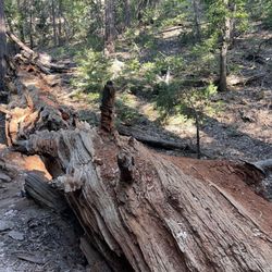
Our crazy adventure began with a miss route into a wilderness of fallen tree trunks and rock climbing. What the scenic route was supposed to be the difficult hike was actually much easier than expected and because there was no way it'd be that easy we kept going and going and going for over a mile and missed the landmark. It took for us to go back and take the paved path to the sign that led us to the correct destination. *facepalm* Three hours of workout lead us to a heart, all that beauty, and some fresh air!
")
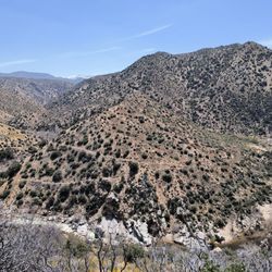
Some treks through nature will lead you to stunning waterfalls and others will lead you to beautiful naturally occurring heart indentation, in rock. May your treks through nature lead you to the most beautiful thing you can discover ... your true self :) Super easy hike that a novice hiker and young children can certainly conquer in a hour or two. Hike is about a 2 mile loop, with AllTrails estimating a 285ft elevation gain. If you want to get closer to the heart rock indentation, then some rock scrambling will be involved. I hiked here in the afternoon and crowds of nice hikers around to ask for directions, if needed. Always bring your "ten essentials" (REI has a good list, if you're clueless to what I'm referring to) always -as it's good to form good outdoor hiking habits. Located near Crestline, California, within the San Bernardino National Forest. Enjoy the journey! Take in the scenic creek, trees, forest and all that Mother Nature freely gives. Stay safe and healthy (mind, body and soul) Yelping out there :)
A place that touches your soul. Heart Rock is magical and breathtaking. A kid friendly hike too! A beautiful waterfall and heart shaped rock all in natures beauty. About a 3 mile hike to and from with plenty of resting spots if needed. We loaded up some snacks and water in a small backpack and found a walking stick along the route. The balancing rocks are neat too left a few builds of our own. Definitely one of my favorite hikes in Ca and it can be one of yours too! Plenty of free parking and a gorgeous scenic ride up to this spot.

It's a perfect family getaway. I'm not used to these kind of experiences so it was pretty exhausting to me but the outcome it's very beautiful. Is not that long, you probably have to walk about 20-25 min before getting to the heart. Make sure to take plenty of water, as the road it's inclined. If you don't want to catch a lot of people go before 11am after 11am, forget it.. you're welcoming crowds of people lol.

1 month ago
This is a great local spot. Parking is pretty spacious. It's about a mile and a half. It has narrow sections and inclines. I would say it's a moderate hike for beginners. The heart is so cute. Perfect for families and dates. You can swim at the bottom. Takes about an hour. read more


15 days ago
Parking is free and ample. It's about a 30-35 minute hike. When you see the gate that says Seely camp, make a left and stay on the trail. The trail is relaxing filled with cute, bushy tailed squirrels. There will be signs that let you know your approaching the heart rock. It's fairly easy to get down just watch your step and wear appropriate shoes with a good grip. read more


I ended up on this fun trail because it's next to camp seely (where they filmed parent trap), but to my surprise it led me to a fun heart rock! I thought i was getting lost a few times but whenever I thought that I found some very kind graffiti telling me where to go lol. Takes an hour total maybe? Very fun would recommend! read more


2 months ago
7 months ago
It was a nice hike. We saw a deer and lots of flying insects. Good for the soul. We didn't notice until the way back but there are spray painted hearts to follow that make finding the heart rock easier. read more


A beautiful hike! Close to lake arrowhead, they're known for the big heart shaped shaving on a rock. I'm really glad I did this hike because this was screaming fall. Yellow leaves, acorns, chilly weather, dry leaves on the ground. Plenty of streams you walk by as well. To get to the heart rock it only took maybe an hour. Then you just come back the same route. Where you start the trail you need to refer to a map because there was no signage of the trailhead. It was 0.4 miles from the parking area where it starts. My family and boyfriend all loved it! read more


3 years ago
This is an easy hike for anyone who is active. If you are sedentary, like most Americans- then this hike could be challenging. Especially if you live down the mountain and are not used to the altitude change. I am out of shape and barely exercise (I know I need to work on this). So, this hike was hard for me. And other people were struggling on the way back. There are hills on the way back, so prepare for that! My boyfriend who is very active, did not have an issue. It was a breeze for him. But he runs daily and is very active. But I would say for most people, this might be a little challenging. My dad brought cans of oxygen just in case and those really did help with the altitude sickness. I strongly recommend those oxygen cans! Life savers lol The trail is rocky and uneven at certain parts. You can slip if you are not careful. But for the most part, it is flat and do-able. There's lots of places to sit on big rocks and take breaks. read more


2 years ago
Loved this trail!! It's a fairly easy trail. It is family and pet friendly and a great hike to go on with little ones. A little more challenging for a toddler as I took my 3 year old and he was struggling at some parts especially towards the end. Overall we had so much fun. I loved seeing the water and the heart rock! read more

1 year ago
Such a beautiful walk and view.. Need to go during the week to enjoy the views. Too many people on the weekend.. read more

What's up: I wanted to go on a hike and I've had this particular one on my list for a while. It's a bit out of my way but I wanted to see what the heart was all about. We decided to go for it one Friday morning! Parking: No designated parking area. You pretty much park on the west side of the road of CA-138. There's a large dirt area that can fit a good number of cars and it's right before the Camp Seely entrance. According to the US Forest Service website, no Adventure Pass is required. Environment: The trail is well marked because so many others have taken the time to leave indicators of where to go. Keep an eye out for the signs and you won't get lost. It's about 2 miles round trip and you'll be hiking along the stream on some parts of the trail. Once you get to the end, carefully descend the rocks to get a view of the heart. For the most part, the trail is shaded. We went early in the morning and ran into one other person. It's a fairly quiet and enjoyable hike, no steep inclines or declines other than the one at the end near the heart. There is no cell signal or restrooms on the trail. Yay/Nay/Meh: Yay. This was a nice and easy hike. It was well shaded and you'll have an enjoyable hike along the river. The little signs along the way helped make the heart easier to find. We didn't go down to the heart but just looked at it over the ledge. It's fairly flat with some minor incline/decline. read more


1 year ago
1 year ago
5 years ago
Easy and beautiful hike! About 10-15 mins from the parking lot you arrive at a sign that will guide you to the rock. So, when you see the sign (second pic), just keep walking for another 5-10 mins, you will see the heart rock and a waterfall. The trail can be slippery. It's also very close to silverwood lake and lake arrowhead. Very beautiful area. Good for nature lovers and family. We took our dog there and he enjoyed it too. Had so much fun exploring! Side note: No cell service! read more


2 years ago
Hiked the trail yesterday with two teens and a tween-ager. We didn't know the route but figured it would be easy to follow. We never veered off the road and walked all the way to a waste water treatment plant. We had to double back and figure out how we missed the trail. The trail is not marked well at all. We finally found it. Great little spot. The water was iced cold and refreshing for sore feet. AND we picked up a ton of trash. People, please remove your trash so others don't have to!!! read more

Our crazy adventure began with a miss route into a wilderness of fallen tree trunks and rock climbing. What the scenic route was supposed to be the difficult hike was actually much easier than expected and because there was no way it'd be that easy we kept going and going and going for over a mile and missed the landmark. It took for us to go back and take the paved path to the sign that led us to the correct destination. *facepalm* Three hours of workout lead us to a heart, all that beauty, and some fresh air! read more


Some treks through nature will lead you to stunning waterfalls and others will lead you to beautiful naturally occurring heart indentation, in rock. May your treks through nature lead you to the most beautiful thing you can discover ... your true self :) Super easy hike that a novice hiker and young children can certainly conquer in a hour or two. Hike is about a 2 mile loop, with AllTrails estimating a 285ft elevation gain. If you want to get closer to the heart rock indentation, then some rock scrambling will be involved. I hiked here in the afternoon and crowds of nice hikers around to ask for directions, if needed. Always bring your "ten essentials" (REI has a good list, if you're clueless to what I'm referring to) always -as it's good to form good outdoor hiking habits. Located near Crestline, California, within the San Bernardino National Forest. Enjoy the journey! Take in the scenic creek, trees, forest and all that Mother Nature freely gives. Stay safe and healthy (mind, body and soul) Yelping out there :) read more
 - Hiking Near Me - Crestline, California")
A place that touches your soul. Heart Rock is magical and breathtaking. A kid friendly hike too! A beautiful waterfall and heart shaped rock all in natures beauty. About a 3 mile hike to and from with plenty of resting spots if needed. We loaded up some snacks and water in a small backpack and found a walking stick along the route. The balancing rocks are neat too left a few builds of our own. Definitely one of my favorite hikes in Ca and it can be one of yours too! Plenty of free parking and a gorgeous scenic ride up to this spot. read more


2 years ago
5 years ago
It's a perfect family getaway. I'm not used to these kind of experiences so it was pretty exhausting to me but the outcome it's very beautiful. Is not that long, you probably have to walk about 20-25 min before getting to the heart. Make sure to take plenty of water, as the road it's inclined. If you don't want to catch a lot of people go before 11am after 11am, forget it.. you're welcoming crowds of people lol. read more

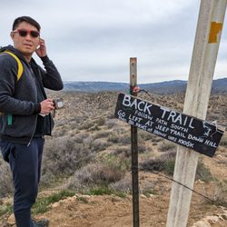
This trail is always a fave! Drivable from LA area (about 1.5 hours with no traffic) and makes for a great morning hike! The trail itself is less than 2 miles long and I'd consider it relatively easy, especially if you're used to California hiking trails - but if you're not used to local trails, I'd say it's more moderate bc there are inclines and some rock scrambling is involved. The trail is mostly pretty obvious up until you get to where the heart rock is...they used to have signs posted to guide you, but I didn't see any this trip. Once you get to a long fallen tree, off to the right there's a slanted "wall" of rocks you'll have to scramble down to see the waterfall and heart shaped pool. If you go off to the left, the trail gets insanely steep and you've gone too far (see my labeled pics). To see the falls and the heart, you'll have to lean over the cliff a bit so be careful! For the more adventurous, you can climb down closer - but be careful as it's very steep and can be slippery! I've seen people rock climbing there many times with ropes and all that gear so it's definitely not just an easy climb. Usually you can drive right up and park at the trailhead, especially if you catch it before 11am when it's uncrowded. There's a small dirt parking lot there. But on this day the road was closed for tree trimming and repairs so we had to park in the area on the side of the road but it wasn't an issue - there's plenty of parking and it's a very short walk up to the trailhead - like maybe 1/2 mile or so. And there was a port-a-potty there too bc of the workers! Which is awesome bc there's no bathroom at this trail and it's pretty remote up in the mountains - so you'll usually want to come with an empty bladder lol! But be aware, this port-a-potty was unstable and it was rocking the whole time I used it lol! It's cold up there this time of year and often gets snow so keep that in mind and check the weather! There's a small creek that runs over part of the road at the entrance and it gets icy! I slipped on some invisible ice and had a pretty nasty fall on this occasion- even in my Salomon boots so be careful! I'm still feeling it lol! read more


1 year ago
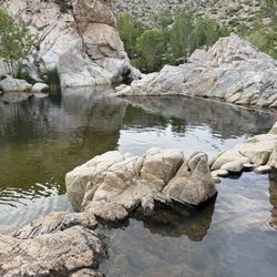
May 27, 2020 It's hot! The trail is very slippery if you don't have the proper (hiking) shoes. Bring bug spray!!! It's four stars for me, despite the bugs. Dress comfortably. Feet may get wet. Water is still a bit chilly right now, but it was cooling with how hot it was today. Fun hike with friends. We got there at 9am and had plenty of parking. Parking is located in front of the sign Camp Seely since the gate was closed. We left the area though around 11:30 AND we had even hiked it to the rock three times because we kept missing it. It's a pretty easy hike, but we didn't pause long or take breaks and the heat got pretty intense. I'd bring easy snacks and more hydration though next time to make it a more leisurely afternoon. The bugs just made it somewhat unbearable. There are shaded areas, but the flies and other bugs are a bit of a distraction. Refer to photos to look for spray paint markings to lead you to Heart Rock. They're marked on the right side of your trail for reference, parallel to the water/creek. I was looking at the ground so much, I overlooked the spray paint markings and caught them on our way back to the car. Here's what I kept missing- There's a cool long tree trunk on my right, that I could easily stand on, and when you see that log/tree trunk, there is another thinner tree log/trunk that runs parallel to the creek. It's here that you have to decipher the two paths. If you are walking downhill and it's really steep, you've missed Heart Rock overlook. Do not exert your energy yet on that steep hill until after you e seen Heart Rock. That path led us to the cool water swimming spots in the river at the bottom (if I revisit). If the water level was higher, I could see how people could slide down some of the rocks like a water slide. FYI: One of my photos shows the long skinny tree trunk that lays horizontally and the two paths (we didn't see this the first time): Left path is a STEEP DOWNHILL grade that leads you to the river Right path is more of a straight path that leads, then a sudden rocky drop you step down, that leads you to what looks like an edge/cliff, but there are more rocks and paths to lead you to Heart Rock. We kept missing this because we thought it was the edge of the hill and nothing past it. My mistake. The hike should have only been a mile, but after my blunders and we got to explore some, it was a total of 3 miles so we had a longer hike than the norm. I was tired and had to get back home to some appts for my son. We got the trail done in two-and-a-half hours but hope to explore the water more next time. I'll revisit super early in the morning, or in the earlier spring season, anytimebefore the bugs swarm the area. read more


Leaving this review now while it's fresh in my mind. This hike was definitely one for the books for me & my family. We had no idea what to expect, based on the reviews i thought it was an easy 20 min hike... No such luck for us. First tip i can say is do not pass the Camp Seely sign, we did thinking there was a parking lot as one of the previous helpers posted. Once we passed the sign it was a pain to mk a U turn. So your Going to park in the dirt off to the left right before the wooden Camp Seely sign. You will see the entrance to the hike from there. 2nd tip I got for u is.. once you get to the split in the road, u will see a nice paved trail to the left & a dirt road to the right.. YOU TAKE the DIRT trail. We made the mistake of staying on the paved trail which we then eventually had to go off road hiking downward to get to the dirt trail. The was a lil challenging. You will see little man made drawings of hearts or signs to let u knw u are on the right track. The pools and steams were definitely worth it. Past heart rock are two pools of water with a man made slide if your daring. Lastly take water, the hike back was mostly uphill and harder than the hike down. In total we did 2.74 miles. Good time! Glad we did it!! read more


if you can't locate the exact address: Search for Camp Seely, 250 CA-138, Crestline, Ca 92325 (in the same area) Date: May 13, 2020 Wednesday @11am with 3 girls, ages 8 and 10 kids friendly, dog friendly need to be on a leash . No bathroom, No trash cans (please bring a bag to take your waste with you) This trail is definitely not strollers or bike friendly. All though it is kids friendly, i wouldn't let my kids run off ahead on their own. The trails are dirt roads, rocks and tree roots and trunks sticking out from the dirt paths. Some sections of the trails are narrow and can accidentally slide to the edge of the trails to the creeks and open space down below, if kids are not careful and horse-playing along the trail. With that being said, it is doable with young kids. My girls had a great time and the hike is not that long (approximately 40 minutes felt to us) Tons of shades all to Heart Rock water fall, Once at the big boulders will see a drop (strongly suggest keep an eye on young kids here) there is no fencing \ barricade of any kind. To see the Heart Rock shape , need to stand on the biggest boulder to your left side . Look down and you then will spot the Heart shape. My girls and I found a spot to hike down to the bottom of water fall, took some memorable pictures, had lunch in the many shaded area and they played skipping rocks and cooled off by getting wet. we than proceeded to walk down the streams all the way to the pond area (don't take your shoes off, water is hyperthermia cold on our feet ) we wore our shoes and continued down the water, which led us to the "pond " . some sections of the pond area had some flat surface rocks to sit and let the girls frolic in the water. We saw some older kids swam in the deeper side of the pond. Pretty much the end of the hike with younger kids once you reached the pond area. Continued any further is much steeper and the trail is narrow. read more


The hike was absolutely amazing! Granted we got lost and made what should have been a 20 min hike into a 2 hour hike to the heart rock lol The actual hike to the heart rock should only take about 20 minutes. There is a point where you can go left on the paved road or right on the dirt road. Either route is easy. Parking is free and right by Camp Sealy. It might be easier to get directions to camp sealy in terms of parking. read more


2 years ago
2 years ago
4 years ago
Superrrr easy trail. Took us maybe 1:15 min there and back and we did a lot of pictures on the way!!! So if you want challenging. No. If you want fun pics totally!!! Great for kids in my option. Good for any age honestly. read more


2 years ago
3 years ago
Really nice hike. Met a few nice people along the way. Perfect length, not too long and not too short. We'll be back.. read more


6 years ago
If anyone knows me and my boyfriend, they would say we are NOT nature people, but with Covid in full swing, we are going to become full-on nature people! Jk, maybe just until the Covid situation gets better. This hike was surprisingly beautiful. I was just excited to see the Heart Rock, but the trees and water on the way there were absolutely stunning! The hike is not bad at all since the path is easy to follow. There was a little bit of an incline in certain places and rocks to climb over, but definitely manageable for beginners! Overall, I was super impressed that there were so many beautiful spots for photos! Nature can actually be quite breath-taking. read more


5 years ago
Great hike. A mile down and another back. No cell service by Seely Camp. Wear good shoes-lots of rocks and uneven trail. Beautiful scenery along the path and the Creek. February was great weather for visiting- not so many people and no bugs-but a little windy and chilly. Lots of great photo spots. Graffiti and trash wasn't as bad as I expected. Still lovely. Good for teenagers and families with older kids. Follow the hearts along the sandy trail. read more


6 years ago
The hike was beautiful. Went early in the AM and felt like we had the entire trail to ourselves. It was nice to see my kiddos enjoying themselves. The water falls are gorgeous and the water is clear and trails are clean. If you plan to visit please take your mask and pick up after yourself keep that trail looking clean and beautiful. Thanks!!! Trail is good for teenagers wouldn't recommend taking little ones. read more


If you're traveling in the San Bernardino Mountains with family and looking for a small hike for cool pictures and a cute little family experience for all ages this is your spot. My mom and I stopped by to hike this before making the drive home from Lake Arrowhead. It was well on the way out which was convenient for driving time and gas. The "trailhead" was not hard to find, though we did go on a weekend so others were out exploring as well meaning numerous cars were parked in the suggested parking area on maps. Where you park and where the trailhead starts are a small walk up the dirt road from each other. Once you find the trailhead it's easy peasy from there, just enjoy the creek to your right going in and the amazing trees to your left. There is a little bit of an incline here and there but the hike to the rock is so short almost anyone can do it. We knew where the heart rock would be from the markings on the trees and the voices of all the tourists already there. If no one is there on the day you visit, though it may be a little tricky to find. All I can say is look for a beaten path to your right and follow the tree scratches if you can. It's about 15-20 minutes in from the trailhead. I believe there's a lot more to the path after the heart rock but I was sandals and it was cold and mucky so went went and explored the ghost town around Lake Gregory which was super interesting too. read more


6 years ago
Beautiful scenery, though the experience was marred by litter and graffiti. Although I didn't make it to the rock (1 adult, 2 toddlers), I saw plenty of beautiful scenery -- lush creek banks, towering cedar and deciduous trees. Plenty of water in the creek even though it hasn't rained in months. This area is so much greener than the typical Jeffrey pine/manzanita/chaparral found elsewhere in the San Bernardino mountains. Although the trail was busy, there was plenty of creek area to play in without anyone else around. It was a joy to spend time somewhere so beautiful. I was disappointed by the human impact on the trail. It seemed very odd to see graffiti on rocks and trees and trail signs in nature, especially in such a pretty area. I thought I was done seeing graffiti when I left San Bernardino on Highway 18, but I was wrong. I guess this trailhead is too close to the city. I haven't noticed this problem on other hikes like Little Green Valley, Exploration Trail, or Little Bear Creek. There was also a lot of litter in the parking area as well. Totally worth it due to the sheer natural beauty, but be prepared to tune out music from backpack stereos and see occasional graffiti/litter along the way. read more


Enjoyed this hike with my kids, it is kid friendly, not too long. We didn't find the heart rock so we will have to go back because it started raining on us at the end! It was fun and an adventure! The only hard part was crossing the water at the beginning of the hike, might be best to bring some rain boots or hiking books you don't mind getting a little wet. We were able to find a part up the road a little that had some good branches to walk across. Looks like a fun place to swim in the summer, I read it has some areas you can slide on in the summer. It was sad to see the trees marked for chopping down. read more


short about~ 20-30minutes leisurely hike with well marked trails. Some areas with an incline but definitely doable for beginners. Mostly thru wooded areas following a stream, makes it nice and shaded during sunny days. interesting trees and plants along the way. Wear shoes with grip as there are areas with rocks and boulders to navigate. If you have watershoes with grip, bring those along (or wear them with socks during the hike) and you'll get to enjoy a dip in the waterfall/pools, pretty shallow, at most up to waist deep in some areas. Be careful on the ledge, it's a bit slanted and no barriers and can definitely be slippery when wet; so take pics up here BEFORE your shoes get wet. Returning to the parking area may take a bit longer for the little ones as it is uphill. summer/spring, bring mosquitoe repellent. If you have trouble finding the trail, map out Camp Seely. When you see a large sign for the camp, turn left into it and you'll start to see a single lane road and a small sign for heart rock trail. There is no cell phone reception (at least with at&t) once you get to this area, so be sure to either pay attention to the road getting here or screenshot your map on the way here to help you get back to the freeway. Lastly, no restrooms. Happy trails everyone! read more


6 years ago
Page 1 of 6
More info about Heart Rock
250 N Hwy 138
Crestline, CA 92325
Directions
Visit Website
http://www.fs.usda.gov/recarea/sbnf/recreation/hiking/recarea/?recid=26321&actid=50
Hours
Indoor Amenities
Outdoor Amenities
Heart Rock Reviews in Other Languages
Ask the Community - Heart Rock
Is this place pet friendly? I have a few dogs I'm trying to socialize:) thank you
There was people there with dogs on leashes but the trail does get narrow in some spots you'd be really close to people if they have dogs
Is it Stroller friendly ?thank you
I would not suggest bringing a stroller on this hike. It is pretty easy, but lots of rocks and roots would make it a pretty bumpy ride. You can see our pictures here… Read more
Where would I park? And how much is the fee for parking? Are we allowed to swim in the waterfall?
There is no fee. There are a couple dirt areas where people park near the turn off. From there, I'd say it's about a 15 to 20 min. walk. You can go into the water, it's not deep enough to swim, however we went in January. It may be different in the… Read more
Review Highlights - Heart Rock
You might also consider


Why does Yelp recommend reviews?
9 reviews that are not currently recommended
The reviews below are not factored into the business's overall star rating.
7 years ago
6 years ago
8 years ago
5 years ago
9 years ago
4 years ago
13 years ago
10 years ago
11 years ago
Heart Rock - hiking - Updated June 2026
Best of Crestline
People found Heart Rock by searching for…
Things to Do in Crestline, California
Attractions in Crestline, California
Hiking Trails With Waterfalls in Crestline, California
Beaches in Crestline, California
Swimming Holes in Crestline, California
Parks in Crestline, California
Campgrounds in Crestline, California
Places to Take Pictures in Crestline, California
Snow Play in Crestline, California
River Swimming in Crestline, California
Beautiful Views in Crestline, California
Photo Spots in Crestline, California
Dog Friendly Things to Do in Crestline, California
Scenic Drive in Crestline, California
Scenic Views in Crestline, California
Secret Spots in Crestline, California
Fishing in Crestline, California
Natural Hot Springs in Crestline, California
Dog Friendly Beaches in Crestline, California
Walking Trails in Crestline, California
Rock Climbing in Crestline, California
Swimming Lakes in Crestline, California
Trending Searches in Crestline, CA
Black Owned Nail Salons near Heart Rock
Jet Ski Rental near Heart Rock
Off Road Trails near Heart Rock
Outdoor Activities near Heart Rock
Places To Walk Around near Heart Rock
River Swimming near Heart Rock
Running Trails near Heart Rock
Scenic Night View near Heart Rock
Scenic Overlook near Heart Rock
Secluded Spots near Heart Rock
Strawberry Picking near Heart Rock
Swimming Holes near Heart Rock
Browse Articles
Browse Nearby
BEST of Crestline, California Restaurants near Heart Rock
BEST of Crestline, California Coffee near Heart Rock
BEST of Crestline, California Things to Do near Heart Rock
BEST of Crestline, California Parks near Heart Rock
BEST of Crestline, California Scenic View near Heart Rock
BEST of Crestline, California Breakfast near Heart Rock
BEST of Crestline, California Hot Springs near Heart Rock
Browse Brands
Related Searches in Crestline, CA
Best Fishing Locations and Guides in Crestline, California
Best Nature Trails for Hiking in Crestline, California
Best Places for Horseback Riding in Crestline, California
Best Sledding Spots and Fun in Crestline, California
Best Waterfalls and Swimming Holes in Crestline, California
Check Out Off Road Trails in Crestline, California
Discover Dog Friendly Trails to Explore in Crestline, California
Discover Kid Friendly Hiking Trails in Crestline, California
Discover Scenic Bike Paths in Crestline, California
Discover Scenic Waterfall Spots in Crestline, California
Discover Top Nature Parks to Visit in Crestline, California
Discover Walking Parks in Crestline, California Near You
Discover a Hiking Trail in Crestline, California
Discover the Best Night Hike Trails in Crestline, California
Discover the Best Running Track in Crestline, California
Dog-Friendly Hikes With Dogs in Crestline, California
Enjoy Camping Adventures Around Crestline, California
Enjoy Exciting Mountain Biking Adventures in Crestline, California
Enjoy Kayaking Adventures in Crestline, California
Enjoy Tent Camping Spots Around Crestline, California
Enjoy a Beautiful Waterfall Hike in Crestline, California
Enjoy the Best Picnic Spots and Ideas in Crestline, California
Enjoy the Best Tubing Experiences in Crestline, California
Enjoy the Best Walking Path in Crestline, California
Enjoy the Best Walking Trails in Crestline, California
Exciting Cliff Jumping Spots in Crestline, California
Explore Beautiful Parks and Green Spaces in Crestline, California
Explore Easy Hikes Perfect for All in Crestline, California
Explore Fun Activities to Do in Crestline, California
Explore Popular Campgrounds Near Crestline, California
Explore Top Dog Parks in Crestline, California Near You
Explore the Best Beach Spots in Crestline, California
Explore the Best Boating Spots in Crestline, California
Explore the Best Swimming Holes Around Crestline, California
Explore the Best Trail Options in Crestline, California
Family Friendly Hiking With Kids in Crestline, California
Find Popular Ziplining Spots Around Crestline, California
Find the Best Parks for Picnics in Crestline, California
Great Places to Walk in Crestline, California
Hiking Trails With Waterfalls in Crestline, California
Off Leash Dog Hiking Trails in Crestline, California
Popular Outdoor Activities to Try in Crestline, California
Popular Picnic Spots to Visit in Crestline, California
Safe River Swimming Areas in Crestline, California
Safe and Fun Parks for Kids in Crestline, California
Top Climbing Spots and Gyms in Crestline, California
Top Running Trails to Explore in Crestline, California
Top Swimming Lakes to Enjoy in Crestline, California
People who viewed Heart Rock also viewed
Will Abell Memorial Trail at Arrowhead Ridge
17 reviews
Bonita Falls
164 reviews
Arrowhead Pinnacles Trail
4 reviews
National Forest Association's Children's Forest
15 reviews
Mormon Rocks Interpretive Trail
8 reviews
Crest Park Picnic Area
2 reviews
Third Stream Falls
13 reviews
Baylis Park
6 reviews
Deep Creek Hot Springs Campground
266 reviews
Lake Gregory Regional Park
578 reviews