San Gorgonio 9 Peaks Challenge Photos


You might also consider
More like San Gorgonio 9 Peaks Challenge
Recommended Reviews - San Gorgonio 9 Peaks Challenge
Start your review...

17 years ago
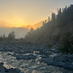
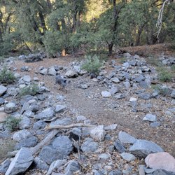
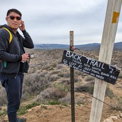
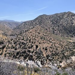
To complete the San Gorgonio 9 Peaks Challenge, you climb up the following 9 peaks along the San Bernadino Peak-San Gorgonio Mountain ridge in a single trip: San Gorgonio Mt. 11,502' Jepson Peak 11,205' Little Charlton Peak 10,696' Charlton Peak 10,806' Alto Diablo 10,563' Shields Peak 10,701' Anderson Peak 10,864' San Bernadino Peak East 10,691' San Bernadino Peak 10,649' The trip can be a dayhike or a multiday backpacking trip, and the order can be done as shown or reversed depending on which trailhead you start at. I did a variation of this hike with a small group of hardcore hikers from the Los Angeles Hiking Meetup group, led by hiker extraordinaire Ze. We started at the Vivian Creek Trailhead, but soon left the trail to take a steep cross-country route to Dobbs Peak (10,469') and East Dobbs Peak (10,510'), so we actually did 11 peaks total. After East Dobbs Peak, we headed to San Gorgonio Mountain and then generally followed the San Bernadino Peak-San Gorgonio Mountain ridge to bag the rest of the peaks, ending with San Bernadino Peak. The descent was generally down Momyer Trail, but we went off-trail quite often to take cross-country shortcuts down the mountain. The cross-country shortcuts were actually really fun, but were a lot steeper than staying on the regular trail and resulted in a few slips and slides. Also, the upper part of Momyer Trail had quite a bit of buckthorn, so long pants are highly recommended. With all our shortcuts, the hike was about 21 miles with 8700 feet elevation gain. One unique thing about this SoCal hike is that such a large portion of the hike is above 10,000 feet elevation. Once you bag the first peak, you stay above 10,000 feet until after you bag the final peak and begin your descent. In our case, about 12 miles of the hike was above 10,000 feet. The extended hiking at high altitude can really make the hike tough. read more


12 years ago
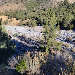
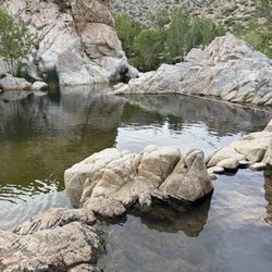
Okay so this I actually not the correct spot to start the 9 peak challenge and the pin falls a little short from where you are supposed to park. Now this trail start will lead you to the San Gorginio east peak or if you do not want to to head to the peak there are 2 beautiful creeks that will fork to the right when you head up 4 miles up the mountain. Now the best part about this hike is that you are able to camp out at the two creeks. My GF and I just camped down there last week and had one of the most relaxing fun time just hanging by the creek. The first creek name is Alger Creek and the second Dob Creek both are awesome to stay at. You will need to stop at the ranger station to check in and let them know how long you will be out there for. Now in the summer time the first 4 miles up the mountain are very brutal because of the heat. We started at 7:15am and the sun was already starting to heat up but by starting tht early the hike was very enjoyable especially cuz we were caring up all out gear. We made it to camp around 1030am and enjoyed how quiet and secluded it was at the campsite. This hike is definitely more for advance hikers in my opinion. I have seen a lot of people turn back due to the steep climb up but if you make it past the first 4 miles, the reward is definitely worth it. I recommend this trail for backpackers who want a quick get away from the city without having to travel to the Sequoias or Yosemite. Also you have to cross a very dried up creek from where you park to even get to the start of this trail head read more

More info about San Gorgonio 9 Peaks Challenge
Valley Of The Falls Dr
Forest Falls, CA 92339
Directions
Hours
Outdoor Amenities
You might also consider


San Gorgonio 9 Peaks Challenge - hiking - Updated May 2026
Best of Forest Falls
People found San Gorgonio 9 Peaks Challenge by searching for…
Campgrounds in Forest Falls, CA
Hiking Trails With Waterfalls in Forest Falls, CA
Things to Do in Forest Falls, CA
Camping Sites in Forest Falls, CA
Secluded Spots in Forest Falls, CA
Redwood Trees in Forest Falls, CA
Playgrounds in Forest Falls, CA
Scenic View in Forest Falls, CA
Tent Camping in Forest Falls, CA
Lakes & Ponds in Forest Falls, CA
Walking Trails in Forest Falls, CA
Beautiful Views in Forest Falls, CA
Running Trails in Forest Falls, CA
Fall Foliage in Forest Falls, CA
Camping Cabins in Forest Falls, CA
Hiking Groups in Forest Falls, CA
Off Road Trails in Forest Falls, CA
Playgrounds for Kids in Forest Falls, CA
Places to Take Pictures in Forest Falls, CA
Browse Nearby
BEST of Forest Falls, California Parks near San Gorgonio 9 Peaks Challenge
BEST of Forest Falls, California Restaurants near San Gorgonio 9 Peaks Challenge
BEST of Forest Falls, California Coffee near San Gorgonio 9 Peaks Challenge
BEST of Forest Falls, California Things to Do near San Gorgonio 9 Peaks Challenge
BEST of Forest Falls, California Waterfalls near San Gorgonio 9 Peaks Challenge
BEST of Forest Falls, California Breakfast near San Gorgonio 9 Peaks Challenge
BEST of Forest Falls, California Sledding near San Gorgonio 9 Peaks Challenge
BEST of Forest Falls, California Campgrounds near San Gorgonio 9 Peaks Challenge
BEST of Forest Falls, California Hotels near San Gorgonio 9 Peaks Challenge
Browse Brands
Browse Articles
People who viewed San Gorgonio 9 Peaks Challenge also viewed
Carriage Trail
2 reviews
Zanja Peak Trail Head
8 reviews
Natural Parkland Trail Head
6 reviews
Crafton Hills Ridge Trail
14 reviews
San Gorgonio South Fork Trail
3 reviews
San Timoteo Nature Sanctuary
13 reviews
Oakmont Park
9 reviews
Blue Mountain Trail
21 reviews
Orange Blossom Trail
5 reviews
Momyer Creek Trail to San Bernardino East Peak
6 reviews