Tecopa Cemetery Photos


More like Tecopa Cemetery
Recommended Reviews - Tecopa Cemetery
Start your review...

4 years ago


13 years ago
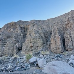
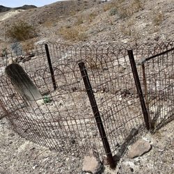
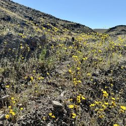
It's quite weird to write a review for a cemetery as a viewer, but here it is. I have been to Tecopa many times and I find the area to not only be fascinating, but a beautiful place. I loved visiting the Tecopa cemetery because it was this amazing, beautiful and peaceful place. One thing that I really envy about the desert people is that they really try and go for the more natural burial. i think it is a beautiful thing to bury your loved ones on the top of hills and in a more 'natural" site. This vemetery is beautiful. read more

More info about Tecopa Cemetery


Why does Yelp recommend reviews?
1 review that is not currently recommended
The reviews below are not factored into the business's overall star rating.
3 years ago
Tecopa Cemetery - landmarks - Updated July 2026
Best of Tecopa
People found Tecopa Cemetery by searching for…
Hot Springs in Tecopa, California
Things to Do in Tecopa, California
Cemetery in Tecopa, California
Post Offices in Tecopa, California
Attractions in Tecopa, California
Historical Sites in Tecopa, California
Photo Spots in Tecopa, California
Things to See in Tecopa, California
Public Services & Government in Tecopa, California
Scenic Overlook in Tecopa, California
Scenic View in Tecopa, California
Abandoned Places in Tecopa, California
River Walk in Tecopa, California
Observation Deck in Tecopa, California
Postal Service in Tecopa, California
Landmarks in Tecopa, California
Places to Visit in Tecopa, California
Night View in Tecopa, California
Sightseeing in Tecopa, California
Trending Searches in Tecopa, CA
Browse Articles
Browse Nearby
BEST of Tecopa, California Things to Do near Tecopa Cemetery
BEST of Tecopa, California Coffee near Tecopa Cemetery
BEST of Tecopa, California Museums near Tecopa Cemetery
BEST of Tecopa, California Hotels near Tecopa Cemetery
BEST of Tecopa, California Restaurants near Tecopa Cemetery
BEST of Tecopa, California Breakfast near Tecopa Cemetery
BEST of Tecopa, California Attractions near Tecopa Cemetery
Browse Brands
Related Searches in Tecopa, CA
Best Fishing Locations and Guides in Tecopa, California
Best Lookout Points to Visit in Tecopa, California
Best Nature Trails for Hiking in Tecopa, California
Book Engaging Historical Tours in Tecopa, California
Check Out Off Road Trails in Tecopa, California
Discover Charming Historic Homes in Tecopa, California
Discover Fun Things to Do Alone in Tecopa, California
Discover Historic Sites and Places in Tecopa, California
Discover Popular Landmarks in Tecopa, California
Discover Popular Photo Spots in Tecopa, California
Discover Stunning Skyline View Spots in Tecopa, California
Discover Top Nature Parks to Visit in Tecopa, California
Discover the Best Dinosaur Park Experiences in Tecopa, California
Enjoy Hiking Adventures in Tecopa, California
Enjoy Scenic Night View Experiences in Tecopa, California
Enjoy the Best Night View Spots in Tecopa, California
Enjoy the Best Walking Trails in Tecopa, California
Experience Stunning Sunset Views in Tecopa, California
Explore Beautiful Castles and Landmarks in Tecopa, California
Explore Free Things to Do Around Tecopa, California
Explore Fun Field Trips in Tecopa, California
Explore Popular Scenic Overlook Points in Tecopa, California
Explore Popular Scenic Views Near Tecopa, California
Explore Popular View Points Around Tecopa, California
Explore Scenic Lakes to Visit in Tecopa, California
Explore Secret Spots Worth Visiting in Tecopa, California
Explore Sunday Fun Things to Do in Tecopa, California
Explore Top History Museums in Tecopa, California
Find Beautiful Views in Tecopa, California
Find Exciting Tours to Take in Tecopa, California
Find Top Art Museums in Tecopa, California
Find the Best Bridge Spots in Tecopa, California
Get Your City Pass for Attractions in Tecopa, California
Must-See Tourist Attractions Around Tecopa, California
Plan a Scenic Drive Route Near Tecopa, California
Popular Indoor Attractions to Visit in Tecopa, California
Popular Places to Take Pictures in Tecopa, California
Popular Places to Walk Around in Tecopa, California
Popular Things to Do in Tecopa, California
Popular Things to See in Tecopa, California
Relax at Natural Hot Springs Near Tecopa, California
Stair Climbing Activities and Gyms in Tecopa, California
Top Places for Stargazing in Tecopa, California
Top Places to Visit in Tecopa, California for Sightseeing
Tour Famous Lighthouses Located in Tecopa, California
Uncover the Best Secluded Spots Around Tecopa, California