Amargosa Waterfall Photos


You might also consider
More like Amargosa Waterfall
Recommended Reviews - Amargosa Waterfall
Start your review...

6 months ago
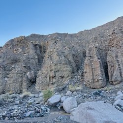
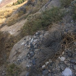
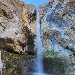
Yes, there's a waterfall in the middle of the desert! What an incredible hike. The hike begins at the China Ranch Farm parking lot, where the China Ranch Trail starts. Clear signs along the way help guide you, and you can also pick up a map at the China Ranch Date Farm store. Be sure to bring plenty of water and snacks to stay hydrated, and always remember to leave no trace. The waterfall was absolutely stunning, such a cool and unexpected sight. A truly great hike! Highly recommend! read more


More info about Amargosa Waterfall
1904 China Ranch Rd
Tecopa, CA 92389
Directions
Hours
Outdoor Amenities


Amargosa Waterfall - hiking - Updated July 2026
Best of Tecopa
People found Amargosa Waterfall by searching for…
Things to Do in Tecopa, California
Hiking Trails With Waterfalls in Tecopa, California
Walking Trails in Tecopa, California
Swimming Holes in Tecopa, California
Abandoned Places in Tecopa, California
What to Do in Tecopa, California
Running Trails in Tecopa, California
Sunday Fun Things to Do in Tecopa, California
Arts & Entertainment in Tecopa, California
Off Road Trails in Tecopa, California
Fun Things to Do at Night in Tecopa, California
Photo Spots in Tecopa, California
Waterfalls in Tecopa, California
Star Gazing in Tecopa, California
Places to Visit in Tecopa, California
Swimming Lakes in Tecopa, California
Ghost Towns in Tecopa, California
Camping & Campsites in Tecopa, California
Trending Searches in Tecopa, CA
Browse Articles
Browse Brands
Related Searches in Tecopa, CA
Best Dog Hiking Trails Around Tecopa, California
Best Fishing Locations and Guides in Tecopa, California
Best Lookout Points to Visit in Tecopa, California
Best Nature Trails for Hiking in Tecopa, California
Best Sightseeing Experiences Available in Tecopa, California
Best Waterfalls and Swimming Holes in Tecopa, California
Check Out Off Road Trails in Tecopa, California
Discover Dog Friendly Trails to Explore in Tecopa, California
Discover Popular Bike Trails in Tecopa, California
Discover Top Boat Tours in Tecopa, California for All Ages
Discover a Hiking Trail in Tecopa, California
Discover the Best Night Hike Trails in Tecopa, California
Dog-Friendly Hikes With Dogs in Tecopa, California
Enjoy Off Leash Dog Hikes in Tecopa, California
Enjoy Tent Camping Spots Around Tecopa, California
Enjoy the Best Walking Trails in Tecopa, California
Experience Stunning Sunset Views in Tecopa, California
Explore Easy Hikes Perfect for All in Tecopa, California
Explore Free Things to Do Around Tecopa, California
Explore Landmarks & Historical Buildings in Tecopa, California
Explore Popular Campgrounds Near Tecopa, California
Explore Popular RV Parks Around Tecopa, California
Explore Popular Scenic Overlook Points in Tecopa, California
Explore Popular Scenic Views Near Tecopa, California
Explore Scenic Lakes to Visit in Tecopa, California
Explore Top Water Parks in Tecopa, California Today
Explore the Best Swimming Holes Around Tecopa, California
Family Friendly Hiking With Kids in Tecopa, California
Find Beautiful Views in Tecopa, California
Find Exciting Tours to Take in Tecopa, California
Find Top-Rated Waterfalls in Tecopa, California Now
Find the Best Scenic View Locations in Tecopa, California
Find the Best Swimming Pools in Tecopa, California Today
Hiking Trails With Waterfalls in Tecopa, California
Off Leash Dog Hiking Trails in Tecopa, California
Perfect Spots to Watch Sunset in Tecopa, California
Plan a Scenic Drive Route Near Tecopa, California
Popular Things to Do in Tecopa, California
Relax at Natural Hot Springs Near Tecopa, California
Safe River Swimming Areas in Tecopa, California
Top Hiking Trails to Explore in Tecopa, California
Top RV Campgrounds to Visit in Tecopa, California
Top Running Trails to Explore in Tecopa, California
Top Things to Do With Kids in Tecopa, California
Top-Rated Camping Sites in Tecopa, California
Uncover the Best Secluded Spots Around Tecopa, California
Visit Popular BBQ Park Locations in Tecopa, California