Mount Rubidoux Trail Photos


You might also consider
More like Mount Rubidoux Trail
Recommended Reviews - Mount Rubidoux Trail
Start your review...

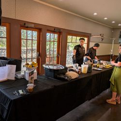
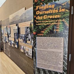
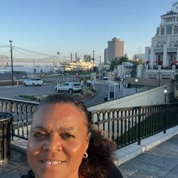
Reviews With Photos


Very cool hike! I'd done this hike years ago but met some friends here this weekend to tackle it once again. It's a little under a 3-mile loop, at least that's what I clocked. Paved the entire way. Incline isn't too bad. It was quite warm when we went, so the shade was nice when we were in it. At the top, the stairs to the cross are quite large, so you're almost hurdling up them. The cross is beautiful though. The views are pretty spectacular as well. The air show taking place at the local airport provided us with a good view of the planes as they circled around the mountain. There's a cool flag and bell tower as well. Lots of great photo ops. There's some food trucks and vendors that sell food, snacks and juices at the base of the mountain. Very cool hike!

This was such a fun trail to hike! I came here early to find free parking at the Ryan Bonaminio Park, and then walked across the street to get to the start of the trail. The trail is fully paved and clean. There were a lot people hiking, too, with their kids and dogs. The trail wraps around the mountain and took me about 1.5 hours to complete (based on my pace). There was a dog that had diarrhea all over the floor...I wonder if someone comes clear the paved road to keep it so clean.


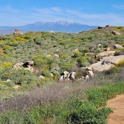
Mount Rubidoux is a city park located near downtown Riverside and is designated as a landmark. It is named after Louis Rubidoux, a successful rancher and early settler to the area. There is no parking lot at the trail but there is street parking five minutes away and also at Ryan Borgamino Park. There is a trail on the mountain that leads up to the Peace Tower. The hike to the summit loop is two miles and the loop around the perimeter is three miles. The trail to the summit is well-maintained and paved which is nice for those walking on it. There's a decent incline which makes for good exercise and you can take your pick between going left or right. I definitely recommend bringing lots of water because even during the winter it can be really sunny with the sun beaming on you. Fortunately there's some shade but not all the way. Overall it took us about an hour to go up and down the trail. The landscape, colors, and rocks remind me of Arizona and gives a desert feel. There are no restrooms but they have doggie bags throughout for your furry friends.


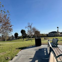
I have loved this little mountain since I was a child. It is my thinking place. When I need a physical workout, mental break, emotional reboot, quick family adventure, or a peaceful place to pray, I ascend Mt. Rubidoux. Well maintained road for walking and trails for hiking. Beautiful views. I recommend parking at Bonaminio Park where you may also use picnic tables and bathrooms.


Great hike with a beautiful 360 view. Took me about 1.5 hour to hike up and down plus took some time to take pictures. There are 2 paths, one is shorter but more steep. The other side is longer but more flat. Both routes are paved. Easy enough for any strollers etc. No bathroom along the way. There are some shades and benches.

4 years ago
Gorgeous view and easy fun hike! It's only about 3 miles round trip, no hiking gear or hiking boots are needed. There are stairs at the beginning of the trail, and 95% paved (along the street on sidewalk, somewhat uphill) Good for any age to hike. The view along the trial is unbeatable, you can see the entire city, and the view at the top is even more rewarding! What makes this hiking trail special is it has some cool historical items along the way! Would recommend to go in the late afternoon for the sunset, pack yourself a light meal and snacks, and of course, water to stay hydrated. I felt like it's relatively dry in the area, and it can be hot during the summer. However, the views at the top are 100% worth your time spent! I recommend this trail. Side note: -Pet friendly & no restrooms! read more


3 years ago
Been here a ton of times and it is a pretty easy and enjoyable trail. There is usually always people there so I felt safe even on the days hiking there alone. It is almost all paved so it is easy to walk on. There are parts that are more steep than others so you'll definitely feel the burn in your legs. Overall a good and quick hiking spot. read more


1 year ago
1 year ago
Easy, family friendly paved trail. This trail is rich is Riverside and California history. It is a bit crowded but everyone was courteous towards one another which was great. Please bring water there isn't much shade on this trail and I did not see any water fountains or restrooms. Definitely worth stopping by to see it if your in the area. The vistas are pretty awesome. Parking I suggest at the Park next to the trailhead. read more


3 years ago
This hike is definitely beautiful & of course who doesn't like a castle/tower. When visiting keep in mind most of the hike is incline on pavement. It's about a 3 mile hike I would say & if you keep going up you reach a huge cross. Parking gets pretty packed due to there also being a park across street as well as vendors . (Before reaching the tower you come across a bride but unfortunately it was closed off Im assuming due to the rain. read more


1 year ago
This is my favorite trail in Riverside! I've lived in the area for several years and wish I discovered it sooner but I've been numerous times since. It's a little over 3 miles long and takes about 1.5 - 2 hours to complete depending on pace. Parking is located at Ryan Bonaminio park and there is some street parking available as well. There are 2 paved paths on this trail, both with benches along the way for breaks. This trail is pretty busy at peak hours. It's stroller and bike friendly! At the top of the trail there is plenty of seating and a beautiful view worth taking pictures of. This trail is dog friendly too! read more


Great hike! About 1 hour round trip! I have done this hike/walk most of my life, and it never gets old. It's a paved road all the way up and down, but it's in need of some TLC, so be careful when you are walking in some areas. Plenty of benches along the way up/down, and lots of scenic spots for pictures. read more

2 years ago
Loved this trail. You can enter through different ways. I came through the dog park, which is dirt incline then pavement. Dog friendly. read more


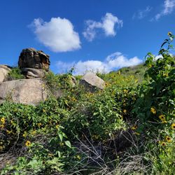
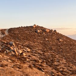
Ton of people on this trail! Not easy to get photos of the place with people all over the background! Parking was about another 0.25 miles to the start of the trail (Bonaminio Park). Total was ~3.25 miles and can be done in ~1 hour and 15 minutes. Trail was on a pavement and easy to follow. It was a steady incline up towards the tower and the cross. The boulders all around the trail were pretty cool to look at though especially since it was close to the city. read more


2 years ago
A solid trail to get away and really see a nice view, 10/10 difficultly is a solid 6/10, Left trail is steeper but get there quicker. Right trail is longer but easier. read more


1 year ago
Awesome paced trail. The incline wasn't hard to handle for a run and as long as you're in decent shape, you're gonna be alright. The trail is asphalt paved, with a few spots and the top portion comprised of dirt and rocks. Once you get up to the top, there's a Father Junipero Serra monument, a huge cross and amazing views of the valley below. I'd definitely recommend this trail for anyone visiting or the local residents, if they don't already know. Until next time my fellow Yelpers...stay hungry and healthy my friends. read more


3 years ago
Mt. Rubidoux a nice walk and part of Riverside history. Like to walk to top with my daughter Elena and have lunch. read more


3 years ago
This a beautiful place to walk with your kids. My 8 yr old and my 5 yr old enjoy the hiking/walking. I do suggest to brink water and dress comfortable. There's a closed park where you can park. read more


Came this morning around 9.30 am and started the hike from Ryan Bonaminio parking. We did the short and direct path up to the cross, in and out. We had a toddler and was pushing a stroller. We made two stops along the way for some rest and a bottle for the little one. We made it back down around 11.30 am. Just in time for lunch. It's a nice workout, walking incline up the mountain, but nothing too crazy. Bring your water and some music and enjoy the nice view. read more


3 years ago
My childhood home mountain; born and raised in Rubidoux and all my childhood I spent waking up to see that grand silhouette with cross a top! My cross country team trained upon Mt Rubidoux while growing up and as an adult with my wife and sometimes our doggie we walk it! Only con though is it's so very popular and there are so many people up and down it now it's like our own version of Grand Central Station! For a nice stroll and don't forget about the 360 views even if just in town on business, it's worth a quick 45 minute or so stroll up and back down if you have half that time walk up 15 and turn around it's enough of a view even with that! Enjoy our local wonder! read more

3 years ago
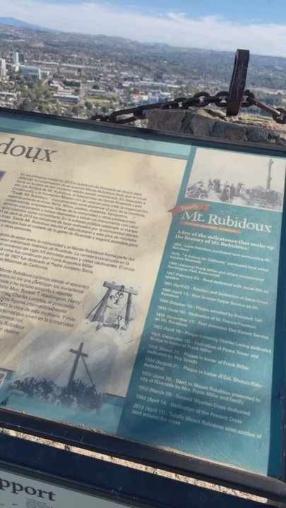
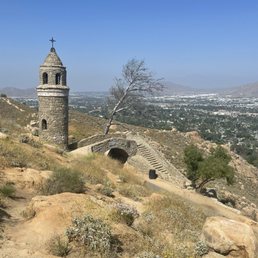
This was my 4th attempt and it finally was a complete success! I took another Yelper's advice and parked at Ryan Boanamanio Park and this time it was a complete success! Beautiful Trail, Beautiful Foliage, beautiful rock formations, lots of placards of its history throughout the way and last but not least.... The View!!! It's amazing!!! I got to walk an old bridge, touch the cross, see the flag... It was totally amazing! read more


Came here for a quick sunset hike with my sister after our Sunday 5K run. It's a fun, short walk that is about 2.5 miles roundtrip approx 400 ft elevation from the car to the top. My sister and I completed this in 40 minutes. Pros: - well paved the entire way - easy parking at Ryan Bonaminio Park (free!) - good signage start at the base - different paths to take but you still wind up in a loop and back down with no problems getting lost - amazing view of Riverside at the top! There's an American flag and a cross that demarcates the top. - family and dog friendly Cons: - not well lit during the evening times, so plan accordingly - can get crowded with large groups on hike - no shade depending on time of day Overall, a great activity for everyone -- families, hikers, runners, and doggies -- and you can get out what you put into it! read more


5 years ago
Cool spot to hike, walk, run. Park on the street or at the park. Lots of people on the trail. Some dirt sections but mostly paved. Nice views of the city from the top. Guy at the corner sells fresh juices. read more


2 years ago
Great hike. About 2.5 miles up and down. 1.25 miles of up hill walk, on a pathed road. Good views, but little shade. Be ready for heat if above 70 degrees. read more


4 years ago
6 years ago
23/ 200 Hike-O-Lishious reviews challenge for 2020, and this fantastic hiking trail has challenged me mentally and physically! Parking: Free Ok, first off, there are two places to park your car. The first one is from the Westside of the mountain, As you're coming up Mission street, you'll see a sign to an entrance that says Riverside, and that's where you want to park! PS: there is also a dog park you can walk fluffy! The parking is small, so go early. 2nd Parking is from the Eastside, where you can park in their recreational park. You will have to walk about 300 Yards to the entrance of the trail. Westside entrance: will take you up some 90' degree incline stairs and a dirt path full of rocks and slippery inclines. My suggestion would be to have some good shoes that can get a good grip, so you can walk over the rocks and boulders you're going to encounter. It's a beautiful hike, but it is a workout. It's all dirt and rocks until about 75% of the way up to where you climb stairs and meet up with a paved path. For me, the beauty of that mountain is seeing the massive cross at the top, which is gigantic! It's a spiritual climb to the gates of heaven, but you have to work for it (all love). Eastside Entrance: This is much easier because it's paved to the top! If you google maps it, the app will bring you to the sports facility where you can park in the street or a parking stall. Suggestions: bring good walking shoes, light clothes, water, snacks, a camera, drone, and sketch pads because it's gorgeous. Once your getting to the top, you are greeted by a beautiful mini stone bridge and tower; it's gorgeous. Pets: You can bring pets; there are no restrictions. The Location: It has plenty of places to sit, gaze, and take selfies while enjoying the scenery that seems endless. The steps to the Cross are huge blocks about (2) feet high, so be ready to climb. However, once you reach the cross, you can sit at the base of it and enjoy a Multi-billion dollar view for free. You can also climb to the mini bridge and take photos, and it's cool. There's also an American flag you can take selfies. I took some excellent photos with Baby Yoda, and he felt right at home. Enjoy this fantastic hike with good people, and there's plenty for one to feel safe. (5) Stars all day! read more


3 years ago
Love this spot! I came here for the first time with my partner about a month ago. The trail takes maybe about 45-60 minutes to get to the top depending on speed and fitness level. It's a fairly easy of a hike/trail. It's beautiful and easy to navigate around. Loads of people of various ages and presumably degrees of physical fitness. Would recommend if visiting riverside read more


6 years ago
My boyfriend and I are NOT hikers or outdoorsy people at all, but with the Coronavirus pandemic, we were looking to do some fun exploring. The trail is relatively easy since the road is nicely paved, and you don't have to walk uphill too much. However, we went during the hottest part of the day in the summer, so it was a little challenging because of the heat. If you go during the summer afternoons, make sure to wear sunscreen and bring plenty of water! We spent about 1.5 hours here enjoying the views and taking tons of pictures. Would definitely recommend checking this place out! read more


6 years ago
2 years ago
Nice mountain view and a nice place for the weekend with your family and your friends and a wonderful time with the kids read more


2 years ago
3 years ago
Amazing family friendly hiking trail, my 5 year old son loves it. Very beautiful views and many different trails read more


6 years ago
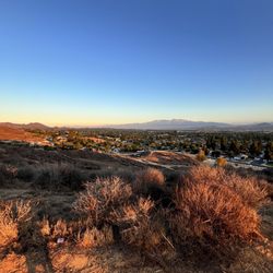
One of the best views in Riverside, as long as you're down for a little hike. The loop going up and back down is roughly 3 miles following a trail. It gets packed unless you go very early. It is mostly incline but the exercise is worth it to see the views! Very dog and family-friendly. Check it out if you're ever in the area! read more


2 years ago
This was a relatively easy hike on a paved trail. From the parking lot at the Ryan Bonaminio Park to the top was about 2.2 miles (via the south trail) and a 500ft elevation gain. There is also a northern trail that is slightly longer (about 0.5 miles longer). The view at the top was beautiful. There were gorgeous rock formations that contrasted well with the green desert shrubbery and blue sky. Of course, there are also the huge white cross and American flag that you'll want to get pictures of. Though this was my first time hiking the trail, it will probably be my last. There were at least a thousand people hiking the trail at the same time, and most of them didn't know proper trail etiquette (if you're an inexperienced hiker reading this, please Google "trail etiquette" and familiarize yourself with all of them). I'm going to list the top 3 that you should know for this trail: 1) If you're a slow hiker, please hike using the rightmost part of the trail so that faster hikers can pass you on the left. Also, if you're going to hike in a large group, please hike in a single file (if you're a family that will be bringing multiple strollers, DO NOT hike side-by-side because you'll be blocking everyone else) 2) Please DO NOT hike while looking at your phone. If you need to look at your phone, please stop somewhere off of the trail. It was unbelievable to see so many hikers looking at their phones and walking into other people. 3) If you're going to bring a dog, please PICK UP your dog's poop and throw it away. Not only is it human decency to pick up your dog's poop, it may be illegal for you to not do so in certain cities/counties. read more


3 years ago
Nice walk up the hill and beautiful views of the city. Girlfriend and I got to the top,as a ceremony for the virgin Maria was coming down. The costumes were beautiful and blessed to have been there to view the celebration. read more


6 years ago
This hike was really fun! It's pretty easy to hike! You can bring your entire family on this hike to enjoy the view of the city and experience nature. It was hot when we went but still very nice! Edit: Dogs are welcomed too! read more


Let's kick off 2018 with something great and positive - hiking! This beautiful trail is paved all around, making it accessible for all ages to experience. It makes the perfect spot for a quick run or walk. This trail is about 2.7 miles RT that loops around in a circle. Up top, you'll find an awesome American Flag and another cross/church-like monument from across the other side. This is dog friendly so take your babies with you and they must be on leash. Parking is quite tricky since most areas are designated for resident parking only with permits. Watch for signs as there are spots to park for free until 9pm. The trail doesn't offer much shade so depending on the day, make sure you put on that sunscreen! Adventure on, everyone! You'll love this place! I promise. read more

 - Hiking Near Me - Riverside, California")


4 years ago
More info about Mount Rubidoux Trail
4706 Mount Rubidoux Dr
Riverside, CA 92501
Directions
Hours
Indoor Amenities
Outdoor Amenities
Mount Rubidoux Trail Reviews in Other Languages
Ask the Community - Mount Rubidoux Trail
Is there a bathroom?
Not on or at Mt. Rubidoux. If you are parking at Ryan Bonaminio Park, there is a bathroom there.
Where can you park closest to trail?
There is a park across the street or there is some street parking.
Are bikes allowed on the trail?
The trail is mainly used by pedestrians- people walking, people walking with strollers, dogs on leashes, small children, groups, people plugged into their earbuds who can't hear anything etc. Wheeled vehicles likes skates, rollerblades and bicycles… Read more
Is this hike safe at night for night photography?
The neighborhood doesn't own the hike trail.
Is this trail open? And what time is it open?
opens 30min before sunrise and closes 30min after sunset
Can anyone advice or know if it will be open? I need a good hike and wanted to hike on Friday.. anyone knows?
It's closed.
Is there a parking area for this trail? Is it easy to find?
They have lots of parking. The park at the bottom of the hill is where you can park your car and walk up.
Is it stroller friendly?
It's paved all the way to the top. But you have to climb stairs to reach the cross as well as the flag. :)
Does the trail have a closing time?
I don't think so. I've seen people there at all hours of the night.
How long does it usually take to complete?
Including parking at Ryan Bonaminio Park, walking up the long easy way and walking down the steep short way without any breaks at a 18 minute/mile pace, it will take you a little over an hour. Total round trip distance is about 3.3 miles. Bring… Read more
Review Highlights - Mount Rubidoux Trail
You might also consider


Why does Yelp recommend reviews?
50 reviews that are not currently recommended
The reviews below are not factored into the business's overall star rating.
13 years ago
15 years ago
8 years ago
4 years ago
9 years ago
5 years ago
9 years ago
6 years ago
7 years ago
14 years ago
11 years ago
10 years ago
8 years ago
12 years ago
5 years ago
3 years ago
4 years ago
15 years ago
8 years ago
11 years ago
Mount Rubidoux Trail - hiking - Updated May 2026
Best of Riverside
People found Mount Rubidoux Trail by searching for…
Beaches in Riverside, California
Hiking Trails in Riverside, California
Beautiful Views in Riverside, California
Star Gazing in Riverside, California
Parks in Riverside, California
Photo Spots in Riverside, California
Scenic Drive in Riverside, California
Scenic Views in Riverside, California
Things to Do in Riverside, California
Places to Take Pictures in Riverside, California
Secret Spots in Riverside, California
Dog Parks in Riverside, California
Fishing Spots in Riverside, California
Dog Friendly Things to Do in Riverside, California
Walking Trails in Riverside, California
Off Road Trails in Riverside, California
Stairs Workout in Riverside, California
Sunset View in Riverside, California
Rock Climbing in Riverside, California
Running Trails in Riverside, California
Meteor Shower in Riverside, California
Sunrise View in Riverside, California
Trending Searches in Riverside, CA
Bird Sanctuary near Mount Rubidoux Trail
Botanical Gardens near Mount Rubidoux Trail
Bounce House Rentals near Mount Rubidoux Trail
Campgrounds near Mount Rubidoux Trail
Cherry Picking near Mount Rubidoux Trail
Cliff Jumping near Mount Rubidoux Trail
Dog Friendly Trails near Mount Rubidoux Trail
Flower Fields near Mount Rubidoux Trail
Flower Shop near Mount Rubidoux Trail
Garage Sales near Mount Rubidoux Trail
Garden Center near Mount Rubidoux Trail
Lakes & Ponds near Mount Rubidoux Trail
Nurseries & Gardening near Mount Rubidoux Trail
Outdoor Activities near Mount Rubidoux Trail
Outdoor Furniture Stores near Mount Rubidoux Trail
Parks near Mount Rubidoux Trail
Party Equipment Rentals near Mount Rubidoux Trail
Pedicure near Mount Rubidoux Trail
Photo Spots near Mount Rubidoux Trail
Pick Your Own Farms near Mount Rubidoux Trail
Picnic Areas near Mount Rubidoux Trail
Places To Take Pictures near Mount Rubidoux Trail
Plant Nursery near Mount Rubidoux Trail
River Swimming near Mount Rubidoux Trail
Rock Quarry near Mount Rubidoux Trail
Running Trails near Mount Rubidoux Trail
Strawberry Picking near Mount Rubidoux Trail
Sunset View near Mount Rubidoux Trail
Browse Articles
Browse Nearby
BEST of Riverside, California Coffee near Mount Rubidoux Trail
BEST of Riverside, California Restaurants near Mount Rubidoux Trail
BEST of Riverside, California Things to Do near Mount Rubidoux Trail
BEST of Riverside, California Breakfast near Mount Rubidoux Trail
BEST of Riverside, California Walking Trails near Mount Rubidoux Trail
BEST of Riverside, California Parks near Mount Rubidoux Trail
BEST of Riverside, California Taxis near Mount Rubidoux Trail
BEST of Riverside, California Campgrounds near Mount Rubidoux Trail
BEST of Riverside, California Hotels near Mount Rubidoux Trail
Browse Brands
Related Searches in Riverside, CA
Best Fishing Locations and Guides in Riverside, California
Best Nature Trails for Hiking in Riverside, California
Best Places for Horseback Riding in Riverside, California
Best Sledding Spots and Fun in Riverside, California
Best Waterfalls and Swimming Holes in Riverside, California
Check Out Off Road Trails in Riverside, California
Discover Dog Friendly Trails to Explore in Riverside, California
Discover Kid Friendly Hiking Trails in Riverside, California
Discover Scenic Walking Paths in Riverside, California, {State}
Discover Scenic Waterfall Spots in Riverside, California
Discover Top Nature Parks to Visit in Riverside, California
Discover Walking Parks in Riverside, California Near You
Discover a Hiking Trail in Riverside, California
Discover the Best Night Hike Trails in Riverside, California
Dog-Friendly Hikes With Dogs in Riverside, California
Enjoy Camping Adventures Around Riverside, California
Enjoy Exciting Mountain Biking Adventures in Riverside, California
Enjoy Kayaking Adventures in Riverside, California
Enjoy Tent Camping Spots Around Riverside, California
Enjoy a Beautiful Waterfall Hike in Riverside, California
Enjoy a Peaceful Nature Walk in Riverside, California
Enjoy a Scenic Walk in Riverside, California, {State}
Enjoy the Best Picnic Spots and Ideas in Riverside, California
Enjoy the Best Walking Trails in Riverside, California
Exciting Cliff Jumping Spots in Riverside, California
Explore Beautiful Parks and Green Spaces in Riverside, California
Explore Easy Hikes Perfect for All in Riverside, California
Explore Fun Activities to Do in Riverside, California
Explore Popular Campgrounds Near Riverside, California
Explore the Best Beach Spots in Riverside, California
Explore the Best Swimming Holes Around Riverside, California
Explore the Best Trail Options in Riverside, California
Family Friendly Hiking With Kids in Riverside, California
Find Popular Ziplining Spots Around Riverside, California
Find the Best Parks for Picnics in Riverside, California
Find the Best Scenic View Locations in Riverside, California
Hiking Trails With Waterfalls in Riverside, California
Off Leash Dog Hiking Trails in Riverside, California
Plan a Scenic Drive Route Near Riverside, California
Popular Outdoor Activities to Try in Riverside, California
Popular Picnic Spots to Visit in Riverside, California
Safe River Swimming Areas in Riverside, California
Safe and Fun Parks for Kids in Riverside, California
Top Climbing Spots and Gyms in Riverside, California
Top Places for Snorkeling in Riverside, California
Top Running Trails to Explore in Riverside, California
Top Swimming Lakes to Enjoy in Riverside, California
Top Swimming Spots and Pools in Riverside, California
People who viewed Mount Rubidoux Trail also viewed
Box Springs Two Trees Trail
38 reviews
Mt. Rubidoux Park
121 reviews
Box Springs Mountain Reserve
60 reviews
Sycamore Canyon Wilderness Park
50 reviews
Sycamore Highland
48 reviews
Bonita Falls
164 reviews
Pumpkin Rock Trail
208 reviews
Martin Tudor Jurupa Hills Regional Park
38 reviews
Skyline Drive Trails
136 reviews
Ryan Bonaminio Park
45 reviews