Box Springs Two Trees Trail Photos


. - Hiking Near Me - Riverside, California")
You might also consider
More like Box Springs Two Trees Trail
Recommended Reviews - Box Springs Two Trees Trail
Start your review...

Reviews With Photos

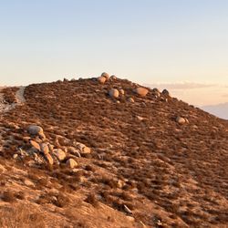
I don't live close to this trail so I put together a few things to make the drive out from Los Angeles worth while and I chose this trail based on its beautifully rugged and Bouldery landscape, as well as the multitude of mentions of donkeys; unsure if they are wild or part of a local ranch. The day was incredibly overcast with a thick and moist marine layer, but since the trail is mostly exposed the entire way, I figured that was a slight win. I didn't see any donkeys on the entire hike, so that was a little disappointing, and the fog was very thick and didn't provide for the excellent views from the top that I've read about, but there is still plenty to see along the trails. Trails are the best part in spring trail, who is beautiful, and on this day, completely saturated with moisture since the trails were slightly overgrown. I was completely soaked and covered in thousands of tiny petals. Once you reach the fire road, the hike is not as appealing, however, you definitely make better time up and down.


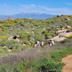
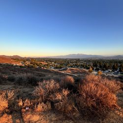
Ready to see a gorgeous view of the Inland Empire? Tucked away in the hills of Riverside, we parked on Two Trees Rd (free parking) that begins the mighty trail to Box Springs Mtn. Beware, this trail can be steep at some points and becomes a bit challenging to breathe as you go up in elevation where the air becomes thin (3,000+ ft).. so be sure to bring lots of water! A roundtrip hike is about 4 miles if I'm not mistaken, and there's plenty of scenic spots to take a quick rest and absorb the beautiful views of Riverside County. As long as you follow the dirt trail, you should be fine as its a very clear path to see. I stumbled upon many snake holes on the ground so always watch your surroundings. As you get to the top of the mountain, there's different trails to take, so be sure to explore those safely. Some tips: * Might be very dangerous to bike. * Parking is limited (head there early as possible on weekends) * Great incline hike, a bit challenging. A moderate hike. * Hiking sticks not necessary, but bring them if you know you need support * Bring tons of water * No shade * Breath-taking views at the peak

Hakuna matata (and don't forget to bring water). The trail wasn't "easy" (it was more of a moderate hike) and super dry and rocky (i would NOT recommend for biking). HEADS UP there's minimal shade, so wear a hat. Trying to find parking was a drag, but we got lucky and found a spot near Belvedere (for free). Overall this was a good work-out and path was clear + easy to follow.

A little challenging at first but this hike is a great way to get into incline hikes. I use to go hiking a lot when I was younger and wanted to get back in to it so I tried this place. My girlfriend has hiked this trail often and loves it. The trail is close to 2 miles to the peak and has a steady incline through out it. When I went the weather was really nice so I was able to enjoy the view as I hiked up. Unlike the Mt. Rubidoux trial this hike is not busy and feels more of hike than the paved walkways at Mt. Rubidoux. As you go up there's spots to take breaks and catch your breath or stop to enjoy the views. As you reach the top you see a road which ends the hike. The view from the top is not that great and I thought the rocky peak to the left was it but it's actually another trail. The right if you walk another mile you reach the M at the side of the mountain side. A familiar landmark as you drive to Moreno Valley. Overall, I enjoyed this hike and would recommend others to try.


Came here early on a Friday morning. Was surprised to literally not see anyone. Hiked all the way up to where you could see the actual road and antenna farms. About an hour walk from the Moreno M. Saw quite a few wild donkeys however kept my distance an everything went amazingly. No snakes or hassles with bugs surprisingly. The hike, the view, the seclusion. Definitely an escape from the city life. Definitely coming back here soon! Bring plenty of water and have your phone charged an you're in for a good time. It was about 97 when I went but even with the lack of shade it wasn't too bad.

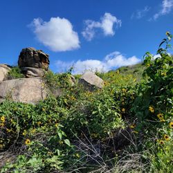
It's an escape from the hustle and bustle of urban life, and the trail is teeming with wildlife. Wild donkeys, lizards, bobcats, all manner of birds and insects you can see here, and the hike is great exercise too! You can go miles up the trail, far out into the serenity of nature, and it can be a pretty rigorous climb at times, but the pathway is always well maintained. No trash or litter to be seen, just grasses, local flora and fauna, and some majestic rock formations. You can also take it slow, and stop at the many views to enjoy the scenery.

Its a leg killer! The hike is certainly uphill without shade for the majority of the time. There are certain spots that require more attention when walking to make sure you don't twist your ankle! I would rate this as an intermediate hike as I didn't think it was easy..or i'm out of shape because there were a couple of elderly men passing me up on the way. We started from the bottom and worked our way up. Once we reached the top, we realized that its another parking lot and you can start from the top and work your way down. There is one small, small water stream in the middle that is hidden away but if you listen for the water then you'll find it.

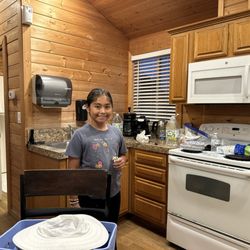
Just came here to take some Christmas photos of the kids and I think they turned out great. Amateur, iPhone photos. The scenery is simple but so much fun and we hardly walked on any trail to reach our photo spots. Want to go back to actually walk the trail too. Didn't get far. But overall a great experience.

4 months ago
Wow what a view! Specially right now. Everything is green. Lots of donkeys everywhere. Got to see them up close. Lots of wildlife. My son was able to see lots of lizards, different kind of bugs and insects. He enjoyed it the most. Pretty easy hike. Even my 5 year old did it. read more


Highly recommend this hike, as the scenery was spectacular. I'm not sure if the mountain is this green all year but cam here in January and it was very green almost comparable to Switzerland green how can it be so green in riverside? It is pretty much an incline the whole way until the top, then we saw a Herd of donkeys. Spotted a few coyotes as well but they are harder to find. Not much shade so prepare water and hats. Then you go downhill on the way back. It is around a 2 hour hike, very nice views! read more


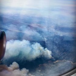
This review is for those who literally want to ascend to the top of the mountain, elevation 2,533 feet. See my Strava course profile below. What starts as a fairly steep trail that shadows a stream most of the way up to the first stage requires some moderate fitness and good trail shoes or hiking boots. My first time coincided with a dense foggy marine layer that kept me cool and clammy most of the way up, a little over 2 miles. I brought a large water bottle and a hiking pole. If it was a lot warmer, though, I recommend using a hydro pack. At the first summit of sorts, which ends at a small park along Box Canyon Springs Road- a dirt road with high embankments on either side. One of the fun objectives is hoping to see the wild donkeys (Burros) that civilization has pushed deeper into the hills and canyons. What progress, right? Fortunately, along the way, you climb up enough for sweeping vistas or dense fog if you're lucky. To go the distance required going a short way down the road where the trail resumes. At this point, I found myself in a tiered plateau, and there through the mist were 16-20 Donkeys! Some baby Donks, too. Keep your distance and zoom in with the camera. The path goes up and up, but it's so green (3rd week of April, 2024) the only thing that marred the sense of isolation is the noise pollution drifting up from the Freeway somewhere out of sight, and planes taking off. Oh well. The summit requires careful navigation, and I got a little turned around in the fog. Be careful because some paths lead to ledges. Unfortunately, this pristine place is heavily tagged with graffiti ranging from Bible verses, professions of eternal love, unintelligible scrawl, and even a symbol known to represent white supremacy and fascism. The way back definitely was felt in my knees, and the sun was quickly burning off the fog. All told, my hike began around 9am, and concluded a little before noon. read more


. - Hiking Near Me - Riverside, California")


. - Hiking Near Me - Riverside, California")
. - Hiking Near Me - Riverside, California")
. - Hiking Near Me - Riverside, California")
3 months ago
4 months ago
I don't live close to this trail so I put together a few things to make the drive out from Los Angeles worth while and I chose this trail based on its beautifully rugged and Bouldery landscape, as well as the multitude of mentions of donkeys; unsure if they are wild or part of a local ranch. The day was incredibly overcast with a thick and moist marine layer, but since the trail is mostly exposed the entire way, I figured that was a slight win. I didn't see any donkeys on the entire hike, so that was a little disappointing, and the fog was very thick and didn't provide for the excellent views from the top that I've read about, but there is still plenty to see along the trails. Trails are the best part in spring trail, who is beautiful, and on this day, completely saturated with moisture since the trails were slightly overgrown. I was completely soaked and covered in thousands of tiny petals. Once you reach the fire road, the hike is not as appealing, however, you definitely make better time up and down. read more


1 year ago
Great views and great place for an easy hike. Watch out for rattlesnakes during summer as we were warned by a local read more


5 years ago
Ready to see a gorgeous view of the Inland Empire? Tucked away in the hills of Riverside, we parked on Two Trees Rd (free parking) that begins the mighty trail to Box Springs Mtn. Beware, this trail can be steep at some points and becomes a bit challenging to breathe as you go up in elevation where the air becomes thin (3,000+ ft).. so be sure to bring lots of water! A roundtrip hike is about 4 miles if I'm not mistaken, and there's plenty of scenic spots to take a quick rest and absorb the beautiful views of Riverside County. As long as you follow the dirt trail, you should be fine as its a very clear path to see. I stumbled upon many snake holes on the ground so always watch your surroundings. As you get to the top of the mountain, there's different trails to take, so be sure to explore those safely. Some tips: * Might be very dangerous to bike. * Parking is limited (head there early as possible on weekends) * Great incline hike, a bit challenging. A moderate hike. * Hiking sticks not necessary, but bring them if you know you need support * Bring tons of water * No shade * Breath-taking views at the peak read more


7 years ago
Hakuna matata (and don't forget to bring water). The trail wasn't "easy" (it was more of a moderate hike) and super dry and rocky (i would NOT recommend for biking). HEADS UP there's minimal shade, so wear a hat. Trying to find parking was a drag, but we got lucky and found a spot near Belvedere (for free). Overall this was a good work-out and path was clear + easy to follow. read more

 - Hiking Near Me - Riverside, California")
 - Hiking Near Me - Riverside, California")

A little challenging at first but this hike is a great way to get into incline hikes. I use to go hiking a lot when I was younger and wanted to get back in to it so I tried this place. My girlfriend has hiked this trail often and loves it. The trail is close to 2 miles to the peak and has a steady incline through out it. When I went the weather was really nice so I was able to enjoy the view as I hiked up. Unlike the Mt. Rubidoux trial this hike is not busy and feels more of hike than the paved walkways at Mt. Rubidoux. As you go up there's spots to take breaks and catch your breath or stop to enjoy the views. As you reach the top you see a road which ends the hike. The view from the top is not that great and I thought the rocky peak to the left was it but it's actually another trail. The right if you walk another mile you reach the M at the side of the mountain side. A familiar landmark as you drive to Moreno Valley. Overall, I enjoyed this hike and would recommend others to try. read more


2 years ago
7 years ago
Wild flowers all around the trail , I felt springs coming ! It's easy trail , follow the direction you would find the parking lot . read more


3 years ago
3 years ago
4 years ago
Came here early on a Friday morning. Was surprised to literally not see anyone. Hiked all the way up to where you could see the actual road and antenna farms. About an hour walk from the Moreno M. Saw quite a few wild donkeys however kept my distance an everything went amazingly. No snakes or hassles with bugs surprisingly. The hike, the view, the seclusion. Definitely an escape from the city life. Definitely coming back here soon! Bring plenty of water and have your phone charged an you're in for a good time. It was about 97 when I went but even with the lack of shade it wasn't too bad. read more


6 years ago
7 years ago
It's an escape from the hustle and bustle of urban life, and the trail is teeming with wildlife. Wild donkeys, lizards, bobcats, all manner of birds and insects you can see here, and the hike is great exercise too! You can go miles up the trail, far out into the serenity of nature, and it can be a pretty rigorous climb at times, but the pathway is always well maintained. No trash or litter to be seen, just grasses, local flora and fauna, and some majestic rock formations. You can also take it slow, and stop at the many views to enjoy the scenery. read more


9 years ago
Its a leg killer! The hike is certainly uphill without shade for the majority of the time. There are certain spots that require more attention when walking to make sure you don't twist your ankle! I would rate this as an intermediate hike as I didn't think it was easy..or i'm out of shape because there were a couple of elderly men passing me up on the way. We started from the bottom and worked our way up. Once we reached the top, we realized that its another parking lot and you can start from the top and work your way down. There is one small, small water stream in the middle that is hidden away but if you listen for the water then you'll find it. read more


7 years ago
Just came here to take some Christmas photos of the kids and I think they turned out great. Amateur, iPhone photos. The scenery is simple but so much fun and we hardly walked on any trail to reach our photo spots. Want to go back to actually walk the trail too. Didn't get far. But overall a great experience. read more


8 years ago
11 years ago
A really nice workout for the knees, thighs, hips & buttocks:D It's nice to have 2 trails in one; it's actually over 3hrs. I Loved the scenery & wished I could have jumped in that Private community lake down below Box Springs trail on the way up to the M. read more


 - Hiking Near Me - Riverside, California")


5 years ago
8 years ago
One of our first real hikes since moving to MoVal a few months ago. The trail was very nice and scenic and we will be back with the grandkids. Pack a lunch, have time to explore and enjoy! read more


7 years ago
Such a beautiful hike. I went right after the rain so that may have skewed my opinion since it was green and lush and looked like i was in Ireland or something. I enjoyed that i was able to go off the trail and far up the mountain also. I'd imagine when it's summer and super hot this hike would not be as enjoyable. Saw a sweet little gray fox on the hill side as well. Ive recommended this hike to a few people because I enjoyed it so much. read more


8 years ago
9 years ago
It's a very nice lil hike, my neighbor & our kid's did the whole loop in 2 hours, while stopping for some cave exploring & found some big bull frogs by the bridge at the end, took 3 breaks for water after some steep spots LOL. Only thing is noticed a lot of baby poison oak sprouting up, the county needs to go spray! read more


This place was incredible with miles and miles of elevation and trails! There is a free parking lot (kinda small) at the trailhead and overflow parking down the road. I suggest you bring extra extra water because this hike is straight up and will ware you out. The views are amazing didn't make it all the way up but maybe some day! read more


7 years ago
I found this hiking spot via online and i did go , man, the hike was a challenge due to the steep trail , i like the fact that its not congested like that ugly rubidoux trail and you got more silently peacefully around you .. did any of you get to the water flow area ? And did you li read more


6 years ago
9 years ago
Nice short trail on the way up with a few shady spots to take a rest. You can find lots of lizards during the summer and it also has nice views of downtown riverside. Not a beginner hike it's moderate the steeping part is near the top take your time it's worth the view. read more


10 years ago
Great hike. I like more challenging climbs and this was intermediate. Beautiful views and overall a fun hike. Love the fact that it merges up to the Box Springs Mountain Park area. From there you can go on several different trails. Very fun for a local hike ! read more

8 years ago
10 years ago
11 years ago
10 years ago
11 years ago
9 years ago
More info about Box Springs Two Trees Trail
430 Two Trees Rd
Riverside, CA 92507
Directions
Hours
Outdoor Amenities
Ask the Community - Box Springs Two Trees Trail
Review Highlights - Box Springs Two Trees Trail
You might also consider


Box Springs Two Trees Trail - hiking - Updated June 2026
Best of Riverside
People found Box Springs Two Trees Trail by searching for…
Photo Spots in Riverside, California
Parks in Riverside, California
Hiking Trails in Riverside, California
Waterfall Hike in Riverside, California
Scenic Views in Riverside, California
Beautiful Views in Riverside, California
Fishing Spots in Riverside, California
Scenic Drive in Riverside, California
Walking Trails in Riverside, California
Places to Take Pictures in Riverside, California
Scenic Spots in Riverside, California
Watch Sunset in Riverside, California
Caves in Riverside, California
Running Trails in Riverside, California
Parks for Kids in Riverside, California
Picnic Spots in Riverside, California
Lakes & Ponds in Riverside, California
Natural Hot Springs in Riverside, California
Free Parking in Riverside, California
Off Road Trails in Riverside, California
Fun Things to Do With Kids in Riverside, California
View Points in Riverside, California
Trending Searches in Riverside, CA
Black Owned Nail Salons near Box Springs Two Trees Trail
Boat Rental near Box Springs Two Trees Trail
Cliff Jumping near Box Springs Two Trees Trail
Day Trips near Box Springs Two Trees Trail
Dog Friendly Trails near Box Springs Two Trees Trail
Fishing Spots near Box Springs Two Trees Trail
Jet Ski Rental near Box Springs Two Trees Trail
Kayak Rental near Box Springs Two Trees Trail
Lakes & Ponds near Box Springs Two Trees Trail
Off Road Trails near Box Springs Two Trees Trail
Outdoor Activities near Box Springs Two Trees Trail
Places To Walk Around near Box Springs Two Trees Trail
Public Pools near Box Springs Two Trees Trail
Public Shower near Box Springs Two Trees Trail
River Swimming near Box Springs Two Trees Trail
Rock Quarry near Box Springs Two Trees Trail
Scenic Night View near Box Springs Two Trees Trail
Scenic Overlook near Box Springs Two Trees Trail
Secluded Spots near Box Springs Two Trees Trail
Soccer Store near Box Springs Two Trees Trail
Splash Pad near Box Springs Two Trees Trail
Strawberry Picking near Box Springs Two Trees Trail
Sunrise View near Box Springs Two Trees Trail
Swimming Holes near Box Springs Two Trees Trail
Swimming Lakes near Box Springs Two Trees Trail
U Pick Farms near Box Springs Two Trees Trail
Watch Sunset near Box Springs Two Trees Trail
Browse Articles
Browse Nearby
BEST of Riverside, California Coffee near Box Springs Two Trees Trail
BEST of Riverside, California Restaurants near Box Springs Two Trees Trail
BEST of Riverside, California Things to Do near Box Springs Two Trees Trail
BEST of Riverside, California Breakfast near Box Springs Two Trees Trail
BEST of Riverside, California Walking Trails near Box Springs Two Trees Trail
BEST of Riverside, California Parks near Box Springs Two Trees Trail
BEST of Riverside, California Hot Springs near Box Springs Two Trees Trail
BEST of Riverside, California Campgrounds near Box Springs Two Trees Trail
BEST of Riverside, California Ski Resorts near Box Springs Two Trees Trail
Browse Brands
Related Searches in Riverside, CA
Best Fishing Locations and Guides in Riverside, California
Best Nature Trails for Hiking in Riverside, California
Best Places for Horseback Riding in Riverside, California
Best Sledding Spots and Fun in Riverside, California
Best Waterfalls and Swimming Holes in Riverside, California
Check Out Off Road Trails in Riverside, California
Discover Dog Friendly Trails to Explore in Riverside, California
Discover Kid Friendly Hiking Trails in Riverside, California
Discover Scenic Waterfall Spots in Riverside, California
Discover Top Nature Parks to Visit in Riverside, California
Discover Walking Parks in Riverside, California Near You
Discover a Hiking Trail in Riverside, California
Discover the Best Night Hike Trails in Riverside, California
Dog-Friendly Hikes With Dogs in Riverside, California
Enjoy Camping Adventures Around Riverside, California
Enjoy Exciting Mountain Biking Adventures in Riverside, California
Enjoy Kayaking Adventures in Riverside, California
Enjoy Tent Camping Spots Around Riverside, California
Enjoy a Beautiful Waterfall Hike in Riverside, California
Enjoy a Peaceful Nature Walk in Riverside, California
Enjoy the Best Picnic Spots and Ideas in Riverside, California
Enjoy the Best Walking Path in Riverside, California
Enjoy the Best Walking Trails in Riverside, California
Exciting Cliff Jumping Spots in Riverside, California
Explore Beautiful Parks and Green Spaces in Riverside, California
Explore Easy Hikes Perfect for All in Riverside, California
Explore Fun Activities to Do in Riverside, California
Explore Popular Campgrounds Near Riverside, California
Explore the Best Beach Spots in Riverside, California
Explore the Best Swimming Holes Around Riverside, California
Explore the Best Trail Options in Riverside, California
Family Friendly Hiking With Kids in Riverside, California
Find Popular Ziplining Spots Around Riverside, California
Find the Best Parks for Picnics in Riverside, California
Find the Best Scenic View Locations in Riverside, California
Great Places to Walk in Riverside, California
Hiking Trails With Waterfalls in Riverside, California
Off Leash Dog Hiking Trails in Riverside, California
Plan a Scenic Drive Route Near Riverside, California
Popular Outdoor Activities to Try in Riverside, California
Popular Picnic Spots to Visit in Riverside, California
Safe River Swimming Areas in Riverside, California
Safe and Fun Parks for Kids in Riverside, California
Top Climbing Spots and Gyms in Riverside, California
Top Places for Snorkeling in Riverside, California
Top Running Trails to Explore in Riverside, California
Top Swimming Lakes to Enjoy in Riverside, California
Top Swimming Spots and Pools in Riverside, California
People who viewed Box Springs Two Trees Trail also viewed
Mount Rubidoux Trail
544 reviews
Santa Ana River Trail - Hidden Valley Wildlife Reserve Entrance
27 reviews
Challen Hill Park
12 reviews
Blue Mountain Trail
21 reviews
Louis Rubidoux Nature Center
4 reviews
Martha McLean - Anza Narrows Park
15 reviews
Hidden Valley Wildlife Area
15 reviews
San Gorgonio via Vivian Creek
54 reviews
Bonita Falls
164 reviews
Tin Mine Canyon Trail
9 reviews