Mount Rubidoux Trail Photos


You might also consider
More like Mount Rubidoux Trail
Recommended Reviews - Mount Rubidoux Trail
Start your review...

Reviews With Photos

Very cool hike! I'd done this hike years ago but met some friends here this weekend to tackle it once again. It's a little under a 3-mile loop, at least that's what I clocked. Paved the entire way. Incline isn't too bad. It was quite warm when we went, so the shade was nice when we were in it. At the top, the stairs to the cross are quite large, so you're almost hurdling up them. The cross is beautiful though. The views are pretty spectacular as well. The air show taking place at the local airport provided us with a good view of the planes as they circled around the mountain. There's a cool flag and bell tower as well. Lots of great photo ops. There's some food trucks and vendors that sell food, snacks and juices at the base of the mountain. Very cool hike!

This was such a fun trail to hike! I came here early to find free parking at the Ryan Bonaminio Park, and then walked across the street to get to the start of the trail. The trail is fully paved and clean. There were a lot people hiking, too, with their kids and dogs. The trail wraps around the mountain and took me about 1.5 hours to complete (based on my pace). There was a dog that had diarrhea all over the floor...I wonder if someone comes clear the paved road to keep it so clean.


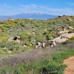
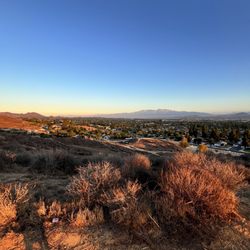
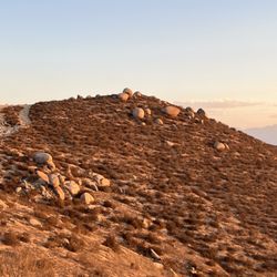
Mount Rubidoux is a city park located near downtown Riverside and is designated as a landmark. It is named after Louis Rubidoux, a successful rancher and early settler to the area. There is no parking lot at the trail but there is street parking five minutes away and also at Ryan Borgamino Park. There is a trail on the mountain that leads up to the Peace Tower. The hike to the summit loop is two miles and the loop around the perimeter is three miles. The trail to the summit is well-maintained and paved which is nice for those walking on it. There's a decent incline which makes for good exercise and you can take your pick between going left or right. I definitely recommend bringing lots of water because even during the winter it can be really sunny with the sun beaming on you. Fortunately there's some shade but not all the way. Overall it took us about an hour to go up and down the trail. The landscape, colors, and rocks remind me of Arizona and gives a desert feel. There are no restrooms but they have doggie bags throughout for your furry friends.


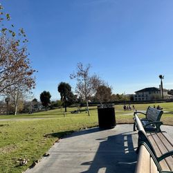
I have loved this little mountain since I was a child. It is my thinking place. When I need a physical workout, mental break, emotional reboot, quick family adventure, or a peaceful place to pray, I ascend Mt. Rubidoux. Well maintained road for walking and trails for hiking. Beautiful views. I recommend parking at Bonaminio Park where you may also use picnic tables and bathrooms.


Great hike with a beautiful 360 view. Took me about 1.5 hour to hike up and down plus took some time to take pictures. There are 2 paths, one is shorter but more steep. The other side is longer but more flat. Both routes are paved. Easy enough for any strollers etc. No bathroom along the way. There are some shades and benches.

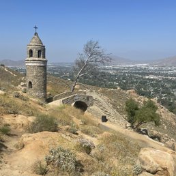
I love that the main trail is paved, which makes it accessible for everyone--| saw plenty of families with strollers and people walking their dogs. It's definitely an incline, but it's not too strenuous since the path wraps gradually around the mountain. It feels more like a brisk, scenic walk than a rugged hike. The absolute highlight for me is the Peace Tower and Friendship Bridge. It looks like something straight out of a fairytale or a European village. It's such a cool, historic landmark to stumble upon halfway up, and it's a great place to stop for a photo or just to catch your breath. read more


What a wonderful hike for families. The nicely paved road up the mountain makes it easy for everyone to go up. Strollers and wheelchairs had no problems. I saw so many families going up pushing strollers and so many kids hiking up with their parents. The views are beautiful from all around. On the top you will see the tower and the bridge. Also the big white cross. So beautiful. Expect about two hours to be here. It's considered easy to moderate hike since the road is paved. But you are going uphill. We parked at the Ryan Bonaminio Park which is free. There are restrooms here but not up on the mountain. So be prepared. read more

6 months ago
7 months ago
Very cool hike! I'd done this hike years ago but met some friends here this weekend to tackle it once again. It's a little under a 3-mile loop, at least that's what I clocked. Paved the entire way. Incline isn't too bad. It was quite warm when we went, so the shade was nice when we were in it. At the top, the stairs to the cross are quite large, so you're almost hurdling up them. The cross is beautiful though. The views are pretty spectacular as well. The air show taking place at the local airport provided us with a good view of the planes as they circled around the mountain. There's a cool flag and bell tower as well. Lots of great photo ops. There's some food trucks and vendors that sell food, snacks and juices at the base of the mountain. Very cool hike! read more


This was such a fun trail to hike! I came here early to find free parking at the Ryan Bonaminio Park, and then walked across the street to get to the start of the trail. The trail is fully paved and clean. There were a lot people hiking, too, with their kids and dogs. The trail wraps around the mountain and took me about 1.5 hours to complete (based on my pace). There was a dog that had diarrhea all over the floor...I wonder if someone comes clear the paved road to keep it so clean. read more


2 months ago
My daughter and I wanted to do something adventurous so we decided to take a nice hike up the mountain trail! It was definitely a great decision, once getting to the top it is worth it!! read more

5 months ago
Love this trail. Easy for beginners and is paved. Scenic views and little rest areas along the way. Get there early to get parking . Hardly any shade so you might want to bring a good hat or umbrella on those sunny days. read more


2 months ago
1 year ago
easy paved hike. There's multiple entrances & exits - the way I go it's about 650ft elevation gain & takes about an hour and a half. Great way to spend some time outdoors. read more

Mount Rubidoux is a city park located near downtown Riverside and is designated as a landmark. It is named after Louis Rubidoux, a successful rancher and early settler to the area. There is no parking lot at the trail but there is street parking five minutes away and also at Ryan Borgamino Park. There is a trail on the mountain that leads up to the Peace Tower. The hike to the summit loop is two miles and the loop around the perimeter is three miles. The trail to the summit is well-maintained and paved which is nice for those walking on it. There's a decent incline which makes for good exercise and you can take your pick between going left or right. I definitely recommend bringing lots of water because even during the winter it can be really sunny with the sun beaming on you. Fortunately there's some shade but not all the way. Overall it took us about an hour to go up and down the trail. The landscape, colors, and rocks remind me of Arizona and gives a desert feel. There are no restrooms but they have doggie bags throughout for your furry friends. read more


4 months ago
Love this place. Underrated perk to being local. Great for exercising and getting out of the house in a productive manner read more

3 months ago
1 year ago
I have loved this little mountain since I was a child. It is my thinking place. When I need a physical workout, mental break, emotional reboot, quick family adventure, or a peaceful place to pray, I ascend Mt. Rubidoux. Well maintained road for walking and trails for hiking. Beautiful views. I recommend parking at Bonaminio Park where you may also use picnic tables and bathrooms. read more


4 months ago
4 months ago
7 months ago
Glad we decided to do this trail with our hiking group "hiking with Jesus " easy trail nothing crazy or climbing. We parked in the park down the hill. Had no issues there's lots of people coming and going from the trail, so you'll find a spot quick. read more


8 months ago
The trail was nice had a fun time with family it was amazing the trail wasn't dirty very clean read more

4 months ago
Great hike with a beautiful 360 view. Took me about 1.5 hour to hike up and down plus took some time to take pictures. There are 2 paths, one is shorter but more steep. The other side is longer but more flat. Both routes are paved. Easy enough for any strollers etc. No bathroom along the way. There are some shades and benches. read more


This is my 2nd time hiking here & I highly recommend it for those looking for an easy to moderate hike depending on which side of the trail you decide to start. There are 2 sides to hiking up to the cross. One is an easy trail which is a paved all the way to the top & the other side is shorter but there are steps & an incline. I've hiked both. Today, hubby & I began from the shorter side & completed it on the easier side & took me about an 1.5hr. The trail is minutes away from downtown Riverside which is convenient to find places to eat after the hike. read more


The trail is about 3 miles full loop. The entire trail is paved which makes it perfect for beginner hikers who are now looking for a challenge. Today I saw a woman on an Electric wheelchair going up the path with her family. I thought it was nice that she had access to enjoy this trail too. Since it is paved, it's good for running too. I like a challenge so I do the trail twice in order to get my 6 miles in. I highly recommend parking at Ryan Bonamino Park and then walking to the trail. Trail is probably 0.2 miles away from the park. read more

3.2-mile loop trail near Riverside, California has different trail entrances I ended up doing 5 miles but it was worth it. Generally considered an easy route, it takes an average of 1 h 26 min to complete. This is a very popular area for running, hiking, and mountain biking, so you'll likely encounter other people while exploring. Parking is available at Ryan Bonaminio Park 5000 Tequesquite Ave, Riverside, CA 92506 from there you will walk around half of the mile to the entrance. Enjoy the trails and please leave no trace. read more


6 months ago
4 months ago
2 years ago
This trail provides some of the best views that I have encountered in Riverside! There is a little bit of a walk from parking to the beginning of the trail. However, if you wanted to go to the top, then that takes some stamina (much more than the walk for parking). So, I think that is OK. I also liked that the trail was paved. Maybe it is a little harder, but it helped me feel comfortable that I would not step on or near any wildlife (such as snakes, etc ). I also learned that there are USDA / UC facilities nearby. So, that was interesting! read more


1 year ago
Can never go wrong with a hike up Mount Rubidoux the view is always breathtaking! If you're visiting California & enjoy nature and hiking visiting Mt. Rubidoux is a must. read more

1 year ago


I opted for an early morning hike on Saturday. It's my first time visiting this location. There is plenty of parking available at a nearby park. (Walking distance away) The path is completely paved. So your shoes won't be getting dirty. I was there around 7am and it was not too busy. The hike is fairly easy. It took me approximately 1hour to complete it. Once you're done you can stop by the cute little food card selling fresh juices and fruit. read more


If you've ever been on the 91 freeway going east from LA and said, "Look at the cross up there, I wonder what's up there", now you know. Oh, was it just me? All of these years I finally discovered what's up there- this 3 mile trail! Sure it's crowded, it's like the Hollywood sign for the IE, with IMO, a much better view. Once at the top you have a 360 degree view and a couple of cool little structures at the top. All uphill but paved so literally anyone can get up there. Park at the nearby park and if you bring your dog (a lot of people do) please pick up your dog's poop! read more


Like anywhere else if you feel it's shady, then it most likely will be unsafe. So use your judgement to hike here either in a group and not at as it gets dark. As beautiful as the sunset and city lights are, I came with my crew, a pepper spray and yeah... a weapon of sort. Glad parking was available at the lot of where the trail begins. Just be smart not to leave anything inviting on vision in your car. Paved trail, a good 3mile hike loop, great view from above, but no bathrooms here so be prepared, that hikers use the boulders to relieve themselves. We opted not to proceed where the cross is because it was getting dark and all the tagging along the way made us feel unsafe. Like you don't want to be at the wrong place at the wrong time. I think I'm ok seeing the cross from the fwy. This trail, the neighborhood just didn't sit right. But if you must cross this trail off your list, practice high caution. Beautiful scenery from the top where we stopped at though. read more


2 years ago
8 months ago
2 years ago
Good hike. I always reward myself some fruit at the bottom of the trail. The trail is paved and fairly safe read more

1 year ago
Good for hiking, paved path. scenery is special. Dog friendly is a big plus. Crowded even on weekdays read more


4 years ago
Gorgeous view and easy fun hike! It's only about 3 miles round trip, no hiking gear or hiking boots are needed. There are stairs at the beginning of the trail, and 95% paved (along the street on sidewalk, somewhat uphill) Good for any age to hike. The view along the trial is unbeatable, you can see the entire city, and the view at the top is even more rewarding! What makes this hiking trail special is it has some cool historical items along the way! Would recommend to go in the late afternoon for the sunset, pack yourself a light meal and snacks, and of course, water to stay hydrated. I felt like it's relatively dry in the area, and it can be hot during the summer. However, the views at the top are 100% worth your time spent! I recommend this trail. Side note: -Pet friendly & no restrooms! read more

Page 1 of 14
More info about Mount Rubidoux Trail
4706 Mount Rubidoux Dr
Riverside, CA 92501
Directions
Hours
Indoor Amenities
Outdoor Amenities
Mount Rubidoux Trail Reviews in Other Languages
Ask the Community - Mount Rubidoux Trail
Is there a bathroom?
Not on or at Mt. Rubidoux. If you are parking at Ryan Bonaminio Park, there is a bathroom there.
Where can you park closest to trail?
There is a park across the street or there is some street parking.
Are bikes allowed on the trail?
The trail is mainly used by pedestrians- people walking, people walking with strollers, dogs on leashes, small children, groups, people plugged into their earbuds who can't hear anything etc. Wheeled vehicles likes skates, rollerblades and bicycles… Read more
Is this hike safe at night for night photography?
The neighborhood doesn't own the hike trail.
Is this trail open? And what time is it open?
opens 30min before sunrise and closes 30min after sunset
Can anyone advice or know if it will be open? I need a good hike and wanted to hike on Friday.. anyone knows?
It's closed.
Is there a parking area for this trail? Is it easy to find?
They have lots of parking. The park at the bottom of the hill is where you can park your car and walk up.
Is it stroller friendly?
It's paved all the way to the top. But you have to climb stairs to reach the cross as well as the flag. :)
Does the trail have a closing time?
I don't think so. I've seen people there at all hours of the night.
How long does it usually take to complete?
Including parking at Ryan Bonaminio Park, walking up the long easy way and walking down the steep short way without any breaks at a 18 minute/mile pace, it will take you a little over an hour. Total round trip distance is about 3.3 miles. Bring… Read more
Review Highlights - Mount Rubidoux Trail
You might also consider


Why does Yelp recommend reviews?
50 reviews that are not currently recommended
The reviews below are not factored into the business's overall star rating.
13 years ago
15 years ago
8 years ago
4 years ago
9 years ago
5 years ago
9 years ago
6 years ago
7 years ago
14 years ago
11 years ago
10 years ago
8 years ago
12 years ago
5 years ago
3 years ago
4 years ago
15 years ago
9 years ago
11 years ago
Mount Rubidoux Trail - hiking - Updated June 2026
Best of Riverside
People found Mount Rubidoux Trail by searching for…
Beaches in Riverside, California
Hiking Trails in Riverside, California
Parks in Riverside, California
Beautiful Views in Riverside, California
Star Gazing in Riverside, California
Photo Spots in Riverside, California
Scenic Drive in Riverside, California
Scenic Views in Riverside, California
Things to Do in Riverside, California
Places to Take Pictures in Riverside, California
Attractions in Riverside, California
Secret Spots in Riverside, California
Dog Parks in Riverside, California
Fishing Spots in Riverside, California
Walking Trails in Riverside, California
Dog Friendly Things to Do in Riverside, California
Off Road Trails in Riverside, California
Sunset View in Riverside, California
Stairs Workout in Riverside, California
Running Trails in Riverside, California
Rock Climbing in Riverside, California
Sunrise View in Riverside, California
Trending Searches in Riverside, CA
Beaches near Mount Rubidoux Trail
Black Owned Nail Salons near Mount Rubidoux Trail
Boat Rental near Mount Rubidoux Trail
Cliff Jumping near Mount Rubidoux Trail
Creeks near Mount Rubidoux Trail
Day Trips near Mount Rubidoux Trail
Dog Friendly Trails near Mount Rubidoux Trail
Fishing Spots near Mount Rubidoux Trail
Free Kids Activities near Mount Rubidoux Trail
Jet Ski Rental near Mount Rubidoux Trail
Lakes & Ponds near Mount Rubidoux Trail
Off Road Trails near Mount Rubidoux Trail
Outdoor Activities near Mount Rubidoux Trail
Pick Your Own Farms near Mount Rubidoux Trail
Places To Walk Around near Mount Rubidoux Trail
Public Shower near Mount Rubidoux Trail
Rock Quarry near Mount Rubidoux Trail
Scenic Drive near Mount Rubidoux Trail
Secluded Spots near Mount Rubidoux Trail
Soccer Store near Mount Rubidoux Trail
Splash Pad near Mount Rubidoux Trail
Strawberry Picking near Mount Rubidoux Trail
Sunrise View near Mount Rubidoux Trail
Swimming Holes near Mount Rubidoux Trail
Swimming Lakes near Mount Rubidoux Trail
Swimming Pools near Mount Rubidoux Trail
Watch Sunset near Mount Rubidoux Trail
Browse Articles
Browse Nearby
BEST of Riverside, California Coffee near Mount Rubidoux Trail
BEST of Riverside, California Restaurants near Mount Rubidoux Trail
BEST of Riverside, California Things to Do near Mount Rubidoux Trail
BEST of Riverside, California Breakfast near Mount Rubidoux Trail
BEST of Riverside, California Walking Trails near Mount Rubidoux Trail
BEST of Riverside, California Parks near Mount Rubidoux Trail
BEST of Riverside, California Taxis near Mount Rubidoux Trail
BEST of Riverside, California Campgrounds near Mount Rubidoux Trail
BEST of Riverside, California Motel near Mount Rubidoux Trail
Browse Brands
Related Searches in Riverside, CA
Best Fishing Locations and Guides in Riverside, California
Best Nature Trails for Hiking in Riverside, California
Best Places for Horseback Riding in Riverside, California
Best Sledding Spots and Fun in Riverside, California
Best Waterfalls and Swimming Holes in Riverside, California
Check Out Off Road Trails in Riverside, California
Discover Dog Friendly Trails to Explore in Riverside, California
Discover Kid Friendly Hiking Trails in Riverside, California
Discover Scenic Waterfall Spots in Riverside, California
Discover Top Nature Parks to Visit in Riverside, California
Discover Walking Parks in Riverside, California Near You
Discover a Hiking Trail in Riverside, California
Discover the Best Night Hike Trails in Riverside, California
Dog-Friendly Hikes With Dogs in Riverside, California
Enjoy Camping Adventures Around Riverside, California
Enjoy Exciting Mountain Biking Adventures in Riverside, California
Enjoy Kayaking Adventures in Riverside, California
Enjoy Tent Camping Spots Around Riverside, California
Enjoy a Beautiful Waterfall Hike in Riverside, California
Enjoy a Peaceful Nature Walk in Riverside, California
Enjoy the Best Picnic Spots and Ideas in Riverside, California
Enjoy the Best Walking Path in Riverside, California
Enjoy the Best Walking Trails in Riverside, California
Exciting Cliff Jumping Spots in Riverside, California
Explore Beautiful Parks and Green Spaces in Riverside, California
Explore Easy Hikes Perfect for All in Riverside, California
Explore Fun Activities to Do in Riverside, California
Explore Popular Campgrounds Near Riverside, California
Explore the Best Beach Spots in Riverside, California
Explore the Best Swimming Holes Around Riverside, California
Explore the Best Trail Options in Riverside, California
Family Friendly Hiking With Kids in Riverside, California
Find Popular Ziplining Spots Around Riverside, California
Find the Best Parks for Picnics in Riverside, California
Find the Best Scenic View Locations in Riverside, California
Great Places to Walk in Riverside, California
Hiking Trails With Waterfalls in Riverside, California
Off Leash Dog Hiking Trails in Riverside, California
Plan a Scenic Drive Route Near Riverside, California
Popular Outdoor Activities to Try in Riverside, California
Popular Picnic Spots to Visit in Riverside, California
Safe River Swimming Areas in Riverside, California
Safe and Fun Parks for Kids in Riverside, California
Top Climbing Spots and Gyms in Riverside, California
Top Places for Snorkeling in Riverside, California
Top Running Trails to Explore in Riverside, California
Top Swimming Lakes to Enjoy in Riverside, California
Top Swimming Spots and Pools in Riverside, California
People who viewed Mount Rubidoux Trail also viewed
Box Springs Two Trees Trail
38 reviews
Mt. Rubidoux Park
121 reviews
Box Springs Mountain Reserve
60 reviews
Sycamore Canyon Wilderness Park
50 reviews
Sycamore Highland
49 reviews
Pumpkin Rock Trail
209 reviews
Bonita Falls
164 reviews
Etiwanda Falls Trail
58 reviews
Skyline Drive Trails
137 reviews
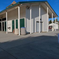
Ryan Bonaminio Park
45 reviews