Mt. Rubidoux Park Photos
. - Hiking Near Me - Riverside, California")


You might also consider
More like Mt. Rubidoux Park
Recommended Reviews - Mt. Rubidoux Park
Start your review...

Reviews With Photos


The mountain is named after Louis Rubidoux, a wealthy ranchero who purchased the mountain in 1852 and established Rancho Rubidoux in 1847. It's an easy hike of 3.5 miles complete. We couldn't find the entrance here is the address to find free parking. trailhead address: Ryan Bonaminio Park, 5000 Tequesquite Ave, Riverside, CA 92506 From there you will walk about half a mile to the entrance. Have a good hike and please leave no trace.
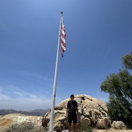
Mount Rubidoux Trail is a trail in Mount Rubidoux Park in Riverside, California. There is plenty of free parking nearby. The entire trail is paved with asphalt and quite wide for a hiking trail. I was there on Memorial Day but yet, it was not that crowded. I saw many people biking. It was a fairly easy and pleasant hike. If you hike the shortest routes and do not repeat any route, it will be just a little over 3 miles. We repeated a few routes so it was a little longer per Apple's Health app. On top of the trail, you will see a large U.S. flag and a peace monument on one side and a huge cross on the other side. #MountRubidouxTrail #MountRubidoux #Hiking https://m.facebook.com/story.php?story_fbid=pfbid02QXAZMM4VWes98iZ16zCU1ND2wMyUHA47J62tf9hnYoEymqaaeS28xATjbjTuJ9yTl&id=61555025878168&mibextid=wwXIfr

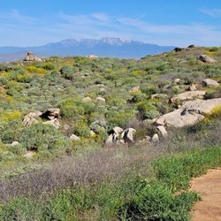
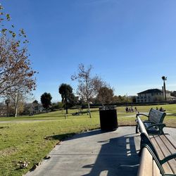
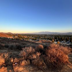
This fun hike is in my hometown and I had not done it in years. While we were visiting I had the opportunity to take my family one morning and we had a great time. This is a 3.2 mile loop up to the top. The trail is paved mostly and it can be very scenic on your way up. The day we hiked it was extremely overcast, typical for December but we made the best of it. Along the way, the mountain features many memorials and historic markers. At the summit, there is a huge cross erected and dedicated to Father Junipero Serro. The cross is 35 feet high. Every Easter Sunday the largest non -denominational outdoor Easter service is held here. Many people hike, walk, run and bike this mountain for exercise and it was busy the morning we were there but not crowded. If you happen to be in the area and want to do something physical, be sure to check this park and hike out.

I enjoy the ease of this hike, as I was able to take my senior Shih tzus along for the journey with no problem! Definitely my favorite place to go to refresh and clean my mind. The only downside is the amount of people you will encounter. Plus this hike is super doggy friendly, so overall it isn't a good one for reactive dogs. You also have to park pretty far from the start of the hike.


This is such a chill and easy 3ish mile full loop hike. Great views with the cross and a princess looking tower on top. Fully paved so a lot of people brought their dogs or babies in a stroller. Easy parking at the park down the street. Not much shade so maybe go on a day that's not too hot. Pretty crowded trail so come early!

We have so much fun hiked at this place. A short hike around three miles both way. Easy to get there with plenty parking space, prefer start early to avoid crowds. You will get 360 degree city views with a giant cross and American flag on top the hill. Overall it's a great place to hike, hangout and spend time with friends and loved ones. Love the cleanest this place, literally I didn't see dog poop or trash. Keep up good work to keep these place clean everyone. Very pleasure Highly recommend

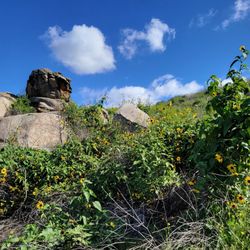
When we arrived, I was planning a quick pit stop, expecting I could drive up to the peak. No such luck but we decided to take the trek and give it a go. We are so glad we did! While it's a long walk (plan 2-3 hours unless you're running), the views were rewarding. Top that with an abundance of wildflowers along the way - even the cactus were blooming. Do bring enough water for this trip!

I don't go on hikes often and this almost 3 mile hike to the cross was doable thanks to the paved path! It was getting warm when we started our midday hike and there were a lot of people. I would have loved to inhale the fresh air but half the time I smelled dog poop. I wish people would be more responsible and clean up after their fur babies.

Looking for an easy hike with awesome views? Then look no further, this is the spot for you! Mt. Rubidoux is one of most popular trails in the Riverside and throughout the Inland Empire area! It's a family friendly hiking spot that has two trails which are slightly easy to conquer. Clear dirt pathways allow you to bring your kids, active pets, bikes, and juvenile strollers from the entrance way - all the way to the very top with no issues. The slight incline might be a little overwhelming if you haven't been active in a while, but always take your time and be cautious of your surroundings. This trail tends to become very busy no matter the time of day. It's an estimated of 5 miles going up once and coming back down, (so 10 miles roundtrip). Think of this trail as an "intense walk". It's a great start to a beginner's hiking trial, with stunning views of the vast valley.

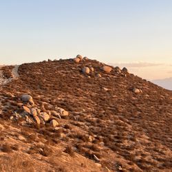
I live in orange County, and this place is 1 hr away. Yet, I found it to be fun, challenging, and soothing. It's fun because the place has many trails that are difficult to novice. It's challenging because the trails are steep slippery and continuously rocky with gravel, always giving way. It is soothing because once your jog walks or runs your way up the trail, you can just relax and enjoy the views. Have a picnic or just exercise as the wind sun and beauty of nature absorb you. You come for the views... the exhilarating exercise and leave happy because it's a great place to visit. Parking is best at the bottom of the hill, where the baseball fields are. Take water and comfy shoes... it's going to be a long long walk...


4 months ago
Update March 2026 Parking: Sunday parking at 0730 hours at Ryan Bonimo park was PACKED!!! You can park on the street, but at your own risk. There are signs that says "No Stopping entire block" Bathrooms: Public restroom at the park. NONE on the trail. Round trip: 2.9 miles with 608' of gradual elevation. I love this easy hike. read more


1 year ago
This was a challenging, awesome hike! It is steep from the parking lot to about 3/4 way up the mountain. Once you get 3/4 way up, there are a couple benches/rocks to get away from the sun and relax for a minute. The top was beautiful and had tons of monuments and cool things to look at. There are multiple ways to get to the top too and you can go different ways around the top of the mountain. It was pretty neat walking around and looking at everything. read more


9 months ago
Great place to hike, get sun, see the view and meet like minded people! If you want to train or get in shape I recommend you visiting this area. read more


The mountain is named after Louis Rubidoux, a wealthy ranchero who purchased the mountain in 1852 and established Rancho Rubidoux in 1847. It's an easy hike of 3.5 miles complete. We couldn't find the entrance here is the address to find free parking. trailhead address: Ryan Bonaminio Park, 5000 Tequesquite Ave, Riverside, CA 92506 From there you will walk about half a mile to the entrance. Have a good hike and please leave no trace. read more


1 year ago
Mount Rubidoux Trail is a trail in Mount Rubidoux Park in Riverside, California. There is plenty of free parking nearby. The entire trail is paved with asphalt and quite wide for a hiking trail. I was there on Memorial Day but yet, it was not that crowded. I saw many people biking. It was a fairly easy and pleasant hike. If you hike the shortest routes and do not repeat any route, it will be just a little over 3 miles. We repeated a few routes so it was a little longer per Apple's Health app. On top of the trail, you will see a large U.S. flag and a peace monument on one side and a huge cross on the other side. #MountRubidouxTrail #MountRubidoux #Hiking https://m.facebook.com/story.php?story_fbid=pfbid02QXAZMM4VWes98iZ16zCU1ND2wMyUHA47J62tf9hnYoEymqaaeS28xATjbjTuJ9yTl&id=61555025878168&mibextid=wwXIfr read more

This fun hike is in my hometown and I had not done it in years. While we were visiting I had the opportunity to take my family one morning and we had a great time. This is a 3.2 mile loop up to the top. The trail is paved mostly and it can be very scenic on your way up. The day we hiked it was extremely overcast, typical for December but we made the best of it. Along the way, the mountain features many memorials and historic markers. At the summit, there is a huge cross erected and dedicated to Father Junipero Serro. The cross is 35 feet high. Every Easter Sunday the largest non -denominational outdoor Easter service is held here. Many people hike, walk, run and bike this mountain for exercise and it was busy the morning we were there but not crowded. If you happen to be in the area and want to do something physical, be sure to check this park and hike out. read more


I enjoy the ease of this hike, as I was able to take my senior Shih tzus along for the journey with no problem! Definitely my favorite place to go to refresh and clean my mind. The only downside is the amount of people you will encounter. Plus this hike is super doggy friendly, so overall it isn't a good one for reactive dogs. You also have to park pretty far from the start of the hike. read more

2 years ago
The most convenient hiking trail and my go to. It's perfect for a quick workout. I love that they have a fountain in the entrance to fill up your water container. The views are always different and beautiful. read more


This is such a chill and easy 3ish mile full loop hike. Great views with the cross and a princess looking tower on top. Fully paved so a lot of people brought their dogs or babies in a stroller. Easy parking at the park down the street. Not much shade so maybe go on a day that's not too hot. Pretty crowded trail so come early! read more


2 years ago
3 years ago
4 months ago
2 years ago
We have so much fun hiked at this place. A short hike around three miles both way. Easy to get there with plenty parking space, prefer start early to avoid crowds. You will get 360 degree city views with a giant cross and American flag on top the hill. Overall it's a great place to hike, hangout and spend time with friends and loved ones. Love the cleanest this place, literally I didn't see dog poop or trash. Keep up good work to keep these place clean everyone. Very pleasure Highly recommend read more


3 years ago
When we arrived, I was planning a quick pit stop, expecting I could drive up to the peak. No such luck but we decided to take the trek and give it a go. We are so glad we did! While it's a long walk (plan 2-3 hours unless you're running), the views were rewarding. Top that with an abundance of wildflowers along the way - even the cactus were blooming. Do bring enough water for this trip! read more


1 year ago
3 years ago
I don't go on hikes often and this almost 3 mile hike to the cross was doable thanks to the paved path! It was getting warm when we started our midday hike and there were a lot of people. I would have loved to inhale the fresh air but half the time I smelled dog poop. I wish people would be more responsible and clean up after their fur babies. read more


6 years ago
Looking for an easy hike with awesome views? Then look no further, this is the spot for you! Mt. Rubidoux is one of most popular trails in the Riverside and throughout the Inland Empire area! It's a family friendly hiking spot that has two trails which are slightly easy to conquer. Clear dirt pathways allow you to bring your kids, active pets, bikes, and juvenile strollers from the entrance way - all the way to the very top with no issues. The slight incline might be a little overwhelming if you haven't been active in a while, but always take your time and be cautious of your surroundings. This trail tends to become very busy no matter the time of day. It's an estimated of 5 miles going up once and coming back down, (so 10 miles roundtrip). Think of this trail as an "intense walk". It's a great start to a beginner's hiking trial, with stunning views of the vast valley. read more

3 years ago
I live in orange County, and this place is 1 hr away. Yet, I found it to be fun, challenging, and soothing. It's fun because the place has many trails that are difficult to novice. It's challenging because the trails are steep slippery and continuously rocky with gravel, always giving way. It is soothing because once your jog walks or runs your way up the trail, you can just relax and enjoy the views. Have a picnic or just exercise as the wind sun and beauty of nature absorb you. You come for the views... the exhilarating exercise and leave happy because it's a great place to visit. Parking is best at the bottom of the hill, where the baseball fields are. Take water and comfy shoes... it's going to be a long long walk... read more


2 years ago
I have been hiking here for many years. Over the years many more hikers have discovered this gem In the city of Riverside. I cherish my walk, run and hikes here! read more


Towering above downtown Riverside the lonely mountain has a commanding view of the river bend and the Jurupa Valley. From its summit one can see for miles in every direction, however, one downside to this is that when the road up was repaved around 2010 is created conditions for overcrowding and annoying clusters of families, baby carriages, and people unaware of their surroundings. The solution? Avoid the place from about 5pm to close. Seriously. The best time is early before the heat kicks in but if extreme temperatures are your thing, ascend midday and expect to see next to no one. I don't recommend riding your bicycle at any time except midday to avoid incidents ranging from unaware pedestrians, kids making sudden bursts into your path and, sadly, piles of dog poop. While bags are provided and many are tied off to bushes along the paths for easy reach, some ignore common decency and the law. Further, some merely toss the bags into the bushes rather than the strategically placed trash cans. There are some good areas where rock climbers can practice their holds and there's a faster, rugged way up and down the mountain on the Mission Avenue side. Parking is more restricted to keep the residents happy so please pay attention to the signs. Over all, it's a nice way to exercise and features some historic structures on the way up but its popularity works against it sometimes. read more


I LOVE THIS PLACE! It is well maintained especially for the amount of people that come through to enjoy this place! Dog owners need to pick up after their dogs and make that a practice. I thought all dog owners know that courtesy. There should be a stand by the Mt Rubidoux Information station signs with a roll of poop baggies to encourage dog owners to pick up after their dogs especially if they will welcome dogs on this beautiful hilltop paved trail. A lot of baby strollers come through too and when the excrements are in the middle of the pathways that can be run over by their tires and ick what a stinky mess that would be for the families trying to enjoy this beautiful place. Sadly this is why we cannot have nice things as well because people come and vandalize this beautiful place with graffiti. I commend the caretakers as they do a pretty good job of painting over the graffiti with beige paint. Come on people! Please respect the beauty of this place and don't destroy it with your "art" especially without permission. Besides the above mentioned concerns above that would really take this place over the top, this is really such an amazing place to for a 3 mile east hike or stroll with various combo of routes to take and different entrances to begin. My friend and I drove up from Imperial Beach, CA by the Mexican/American border and drove up 2 hours early Sunday morning at 6:30am to start our hike at 8:30am. We passed by Evergreen Historic Cemetery before turning left to get to Mt Rubidoux. We parked at RYAN BONAMINIO PARK at the TEQUESQUITE ARROYO, City of Riverside Parks, Recreation & Community Services Department at 5000 Tequesquite Avenue. From there, we walked to the Mt Rubidoux trail entrance passing by a food truck and makeshift fruiteria selling cut up fruit cups with lime & tajin, and water bottles. There is a green water refilling fixture at the gated entrance. This is such a beautiful 3mile hike I highly recommend. It is scenic, clean and relatively safe on an early Sunday morning. There are various ways to get get up to the cross. If you go towards your left, it is a shorter but steeper route getting you to the bridge that leads to the flag and cross! The right route is longer and less steep. It is also more shaded in the morning as you come around the mountain. I can't say enough about this hike but just to come up and experience how cool it is! read more


Dogs are welcome on leash , can bike here too. From the parking lot we started walking towards the cemented walkway , pass the bridge overpass and saw a purple Victorian home. We continued behind the Victorian home fence trail area on the dirt path and started our incline climb, thank goodness some sections had stairs. We realized we took the long way to the mountain top from this point. Hiking through dirt roads until it leads us to a rest area with paved roads. Some sections of the trails have good shades . Every half a mile to a mile benches are provided overlooking the city views . So far this is by far our favorite hiking location. My kids enjoyed their hike. I saw young kids and bAbies in strollers and wagons. But not sure how those parents manage to maneuver those strollers / wagons up and down those dirt trails ? Once we pass the dirt trails it's all paved roads to the top of the cross/ flag. I did notice there are different trails to get to the top, maybe those sections are paved ? Will update again, once we tried a different route to the mountain. read more


Mt. Rubidoux is a great hike! I've done it more than 15 times easily in the past years. Today I just wanted a slow relaxed walk to ease me into the new year! Walk: This is a paved trail with 2 different paths. It is pet friendly and there is plenty of people with children and parents pushing strollers up the hill. If there is anyone that likes to use mountain bikes they totally can! Parking: There are two entrances. One with a parking area at Bonaminio Park and the one with street parking at the main entrance around 10th Street. Beware of street signs to avoid getting a parking ticket. You can find parking on the streets if you look around though! Views: Breathtaking! You can see both sides of Riverside from the top of the mountain. At the peak there is a cross and an American flag where you can take some awesome pictures! It is an easy hike or a hard one depending on how fast you want to do it! It normally takes me about 1 hour to complete the whole hike. read more


5 years ago
Great spot! There are different entrances to the trail. One entrance is near Ryan Bonaminio Park (4800 Tequesquite Ave, Riverside). You can park here and walk up to Entrance on a small street on San Andreas Ave. This way is all paved road and an easy incline all the way to the cross on top. Another entrance is through Carlson Bark Park. This entrance is a dirt path (more rugged) and somewhat windy and not stroller-friendly. It does eventually meets the paved road, but a bit tricky to get there. We had to ask other hikers who were familiar with the trail. Overall, great place with beautiful views. Lots of benches along the way to rest. read more

1 year ago
3 years ago
6 years ago
The views at the top are beautiful. The only reason for the four stars is because this "hike" is not a true hike, it's more of an intense walk. Also, it's really crowded. It's about a 5 mile walk, 10 miles round trip and it's all incline on the way up. You can park at the recreation center down the road and walk from there, which isn't far at all. I would suggest getting their early to avoid all the traffic. But it is a nice and quick trail if you're just trying to get outside for a little bit. read more


6 years ago
I actually love this hike BUT it can get overly crowded which is okay if you prefer crowds but if you have little ones or a dog could be a bit of a challenge ! LOTS of dogs! I think that is awesome but you do see lots of #2 because people don't pick up after their pups The top of the hike is a great spot to have a water break , sight seeing, gratitude practices ! Not much shade - intensity is moderate . If your not used to hiking you can definitely do this and if your a avid hiker you can intensify this by jogging it I always get lost! Easiest way is Ryan Bonominio park! But like I said it gets packed!!! From street parking up to the scenic area and back was just over 3 miles. I think there's different routes you can take to make it longer ! I am unfamiliar with those routes Over all - recommend! read more
 - Hiking Near Me - Riverside, California")
 - Hiking Near Me - Riverside, California")
3 years ago
I've been trying to find new hiking trails that are open during Covid. I saw a friend of mine post from here so I decided to go check it out. Getting there is a bit confusing, there are 2 entrances, 1 by the dog park and one by the huge public park. We parked at the one by the dog park since that's where the gps send me. It was a bit confusing to try and find the trail, thank god my friend knew his way around. It was a nice little hike, everyone was super friendly and the view from the top is beautiful! read more

6 years ago
I love coming here with friends and family, including my dog! There is a paved path to the top so it's even stroller friendly. The paved path doesn't have too much of an incline and it's not too long, so it's a great start for beginner hikers. Just make sure to check the weather first as it gets real hot in Riverside! If you're a more experienced hiker, there are some dirt paths that are steep. There are many spots that let you take in the beautiful view. It can get crowded with people and dogs here, so be aware when choosing what time you'll hike. There is car parking along the street at the base as well as at the park across the street. read more


We parked at the park at the bottom of the hill and walked up to the trail. It was windy so make sure you bring a handkerchief or something to cover your nose, mouth and glasses or goggles to protect your eyes from dust. Same goes for your dog! This hike is fairly easy and great for anyone at any level to hike. Came here on a hot and windy afternoon and hiked the west half of the trail and made it up to the top in about 25 minutes or so? It's one mile up but it's paved road so great for running since you don't have to worry about sliding down dirt roads or losing your footing. The views were great and up at the top it's beautiful especially on a clear day. Next time I'll try hiking up the east side of the mountain as that trail is a bit longer. If I lived closer I'd hike this bad boy everyday and be in great shape! read more

6 years ago
Nice view, clean, good climb, World Peace castle-bridge, huge Cross on the mountain top, bible verses on the boulder at entrance, plenty of free parking spaces, asphalt trails with arrows for traffic flow. read more


6 years ago
This was my first time hiking at Mt. Rubidoux park. It was wonderful experience and even though my legs are so dead after going up hill. It was worth it though. I recommend going early like around 8am since it starts to get busy like around 10am. Also watch out for the dog crap since people don't know how to pick up after their pets read more


Page 1 of 4
More info about Mt. Rubidoux Park
4706 Mt Rubidoux Dr
Riverside, CA 92501
Directions
Hours
Indoor Amenities
Outdoor Amenities
Mt. Rubidoux Park Reviews in Other Languages
Ask the Community - Mt. Rubidoux Park
What time does it close?
Dusk, but the entrance gate on 9th (east) close at 9pm.
Is this open?
Yes! Currently (or maybe it always was) 1/2 hour before dawn to 1/2 hour after dusk.
Review Highlights - Mt. Rubidoux Park
You might also consider


Why does Yelp recommend reviews?
11 reviews that are not currently recommended
The reviews below are not factored into the business's overall star rating.
3 years ago
8 months ago
9 years ago
1 year ago
5 years ago
6 months ago
5 years ago
7 years ago
5 years ago
4 years ago
11 years ago
Mt. Rubidoux Park - hiking - Updated June 2026
Best of Riverside
People found Mt. Rubidoux Park by searching for…
Beaches in Riverside, California
Star Gazing in Riverside, California
Beautiful Views in Riverside, California
Scenic Views in Riverside, California
Scenic Drive in Riverside, California
Hiking Trails in Riverside, California
Sunrise View in Riverside, California
Sunset View in Riverside, California
Flower Field in Riverside, California
Stairs Workout in Riverside, California
Fishing Spots in Riverside, California
Off Road Trails in Riverside, California
Parks in Riverside, California
Secret Spots in Riverside, California
Scenic Spots in Riverside, California
Running Trails in Riverside, California
Walking Trails in Riverside, California
Stargazing in Riverside, California
Waterfall Hike in Riverside, California
Night View in Riverside, California
Watch Sunset in Riverside, California
Scenic Overlook in Riverside, California
Trending Searches in Riverside, CA
Beaches near Mt. Rubidoux Park
Black Owned Nail Salons near Mt. Rubidoux Park
Boat Rental near Mt. Rubidoux Park
Cliff Jumping near Mt. Rubidoux Park
Day Trips near Mt. Rubidoux Park
Dog Friendly Trails near Mt. Rubidoux Park
Fishing Spots near Mt. Rubidoux Park
Free Kids Activities near Mt. Rubidoux Park
Jet Ski Rental near Mt. Rubidoux Park
Lakes & Ponds near Mt. Rubidoux Park
Off Road Trails near Mt. Rubidoux Park
Outdoor Activities near Mt. Rubidoux Park
Pick Your Own Farms near Mt. Rubidoux Park
Places To Walk Around near Mt. Rubidoux Park
Public Shower near Mt. Rubidoux Park
Rock Quarry near Mt. Rubidoux Park
Scenic Drive near Mt. Rubidoux Park
Secluded Spots near Mt. Rubidoux Park
Soccer Store near Mt. Rubidoux Park
Splash Pad near Mt. Rubidoux Park
Strawberry Picking near Mt. Rubidoux Park
Sunrise View near Mt. Rubidoux Park
Swimming Holes near Mt. Rubidoux Park
Swimming Lakes near Mt. Rubidoux Park
Swimming Pools near Mt. Rubidoux Park
Watch Sunset near Mt. Rubidoux Park
Browse Articles
Browse Nearby
BEST of Riverside, California Coffee near Mt. Rubidoux Park
BEST of Riverside, California Restaurants near Mt. Rubidoux Park
BEST of Riverside, California Things to Do near Mt. Rubidoux Park
BEST of Riverside, California Breakfast near Mt. Rubidoux Park
BEST of Riverside, California Walking Trails near Mt. Rubidoux Park
BEST of Riverside, California Parks near Mt. Rubidoux Park
BEST of Riverside, California Taxis near Mt. Rubidoux Park
BEST of Riverside, California Campgrounds near Mt. Rubidoux Park
Browse Brands
Related Searches in Riverside, CA
Best Fishing Locations and Guides in Riverside, California
Best Nature Trails for Hiking in Riverside, California
Best Places for Horseback Riding in Riverside, California
Best Sledding Spots and Fun in Riverside, California
Best Waterfalls and Swimming Holes in Riverside, California
Check Out Off Road Trails in Riverside, California
Discover Dog Friendly Trails to Explore in Riverside, California
Discover Kid Friendly Hiking Trails in Riverside, California
Discover Scenic Waterfall Spots in Riverside, California
Discover Top Nature Parks to Visit in Riverside, California
Discover Walking Parks in Riverside, California Near You
Discover a Hiking Trail in Riverside, California
Discover the Best Night Hike Trails in Riverside, California
Dog-Friendly Hikes With Dogs in Riverside, California
Enjoy Camping Adventures Around Riverside, California
Enjoy Exciting Mountain Biking Adventures in Riverside, California
Enjoy Kayaking Adventures in Riverside, California
Enjoy Tent Camping Spots Around Riverside, California
Enjoy a Beautiful Waterfall Hike in Riverside, California
Enjoy a Peaceful Nature Walk in Riverside, California
Enjoy the Best Picnic Spots and Ideas in Riverside, California
Enjoy the Best Walking Path in Riverside, California
Enjoy the Best Walking Trails in Riverside, California
Exciting Cliff Jumping Spots in Riverside, California
Explore Beautiful Parks and Green Spaces in Riverside, California
Explore Easy Hikes Perfect for All in Riverside, California
Explore Fun Activities to Do in Riverside, California
Explore Popular Campgrounds Near Riverside, California
Explore the Best Beach Spots in Riverside, California
Explore the Best Swimming Holes Around Riverside, California
Explore the Best Trail Options in Riverside, California
Family Friendly Hiking With Kids in Riverside, California
Find Popular Ziplining Spots Around Riverside, California
Find the Best Parks for Picnics in Riverside, California
Find the Best Scenic View Locations in Riverside, California
Great Places to Walk in Riverside, California
Hiking Trails With Waterfalls in Riverside, California
Off Leash Dog Hiking Trails in Riverside, California
Plan a Scenic Drive Route Near Riverside, California
Popular Outdoor Activities to Try in Riverside, California
Popular Picnic Spots to Visit in Riverside, California
Safe River Swimming Areas in Riverside, California
Safe and Fun Parks for Kids in Riverside, California
Top Climbing Spots and Gyms in Riverside, California
Top Places for Snorkeling in Riverside, California
Top Running Trails to Explore in Riverside, California
Top Swimming Lakes to Enjoy in Riverside, California
Top Swimming Spots and Pools in Riverside, California
People who viewed Mt. Rubidoux Park also viewed
Mount Rubidoux Trail
544 reviews
Challen Hill Park
12 reviews
Santa Ana River Trail - Hidden Valley Wildlife Reserve Entrance
27 reviews
Martha McLean - Anza Narrows Park
15 reviews
Louis Rubidoux Nature Center
4 reviews
Fresno Canyon Trail
10 reviews
White Park
12 reviews
Fairmont Regional Park
6 reviews
Glen Avon Heritage Park
9 reviews
Tin Mine Canyon Trail
9 reviews