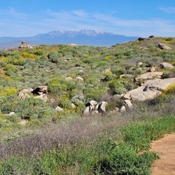
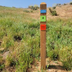
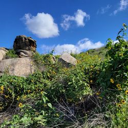
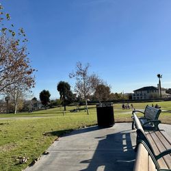
Challen Hill Park Photos


You might also consider
More like Challen Hill Park
Recommended Reviews - Challen Hill Park
Start your review...

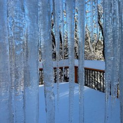
Reviews With Photos

My mom finally convinced me to go walking here(2 weeks ago). I was all excited until we parked and I saw the Rattlesnake sign. I mean, I'm a southern girl from New Orleans. I just didn't realize,"there's snakes on the muthaeffin hill! We had a lovely walk/jog and didn't encounter any snakes but I did see a lot of,"snake holes(gopher holes that the snakes take over). The view was cool and very peaceful to say it wasn't much to see....However, after researching info on rattlesnakes season(March-October), I won't be going back anytime soon. Sn: parents, do not let your kids ride their scooters up and down the dang on hill. A lady was walking behind us with her baby as her two sons played on the hill. All of a sudden, BAM...boo hoooooo mommy! The kid falls off the scooter as he was going down hill. The mother laughed as my mom and I went to help him(wtf). They didn't know any English, so we offered her a spare bottle of water to pour on his scrapped up leg. The poor kid could barely stand....smdh

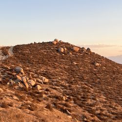
It looks appealing in the winter and early spring when the dominate hill that gives the park its name is brightgreen, but it's not worth going to for hiking unless you live nearby. It's more of a neighborhood park than a destination, really. The rocks on the hill tops (twin peaks) are covered in heavy layers of paint to mask graffiti and the fresh graffiti defeating the periodic efforts to suppress it. Sad, but true. Who's this small park for? Great for dogs. First, there's a small parking lot on the opposite side of the hill when viewed from the south or driving on California Street. The ungroomed trails also beg for riding BMX or mountain bikes. Basic equipment, though, nothing terribly challenging except the steep climb on the SE corner. It was worth visiting to rule it out, but the .74 miles on my Strava app revealed its low value for time and distance. read more


4 years ago
Challen Hill Park was lovely today, Saturday, January 22, 2022. Because of the recent rain, the grass is green! I felt that we had landed in a beautiful botanical garden; and, because of the Santa Anna winds, the Inland Empire was crystal clear--from the top of the hill we could see for miles in every direction! Also, with every breath I took the air felt impossibly fresh and crisp! My dream is that the entire Inland Empire strives to become the world's most beauiful botanical gardens and where her communities vye for top prizes from the American Public Gardens Association...ahhh, wouldn't that be lovely? Warm regards, Eliza Doolittle read more


3 years ago
Sick hiking spot to see the sunset, beautiful place to have a picnic, and just a lovely park overall. Love this place:)!! read more


3 years ago
13 years ago
My mom finally convinced me to go walking here(2 weeks ago). I was all excited until we parked and I saw the Rattlesnake sign. I mean, I'm a southern girl from New Orleans. I just didn't realize,"there's snakes on the muthaeffin hill! We had a lovely walk/jog and didn't encounter any snakes but I did see a lot of,"snake holes(gopher holes that the snakes take over). The view was cool and very peaceful to say it wasn't much to see....However, after researching info on rattlesnakes season(March-October), I won't be going back anytime soon. Sn: parents, do not let your kids ride their scooters up and down the dang on hill. A lady was walking behind us with her baby as her two sons played on the hill. All of a sudden, BAM...boo hoooooo mommy! The kid falls off the scooter as he was going down hill. The mother laughed as my mom and I went to help him(wtf). They didn't know any English, so we offered her a spare bottle of water to pour on his scrapped up leg. The poor kid could barely stand....smdh read more


8 years ago
8 years ago
12 years ago
What a beautiful beginners hike up this hill today. Steep enough upgrades to challenge my glutes & hamstrings a lil' but not too steep where I didn't feel safe or was overly winded at any particular point. I saw lots of squirrels and despite the rattlesnake warning, there was just some broken glass & tiny lizards. At the base of the hill there is a gated dirt parking area. Not too far from the small parking lot were a few benches. A doggy bag post and garbage bin. A few loops up and around and down again gave me a nice tan and workout. The winds were quite strong today at the very top & there was a decent view available. This is appropriate for beginners, kids and any one else wanting to enjoy some sun and fitness. read more


12 years ago
9 years ago
14 years ago
More info about Challen Hill Park
Challen Ave
Riverside, CA 92503
Directions
Hours
Outdoor Amenities
Challen Hill Park Reviews in Other Languages
Ask the Community - Challen Hill Park
Review Highlights - Challen Hill Park
You might also consider


Challen Hill Park - hiking - Updated July 2026
Best of Riverside
People found Challen Hill Park by searching for…
Scenic Views in Riverside, California
Hiking Trails in Riverside, California
Scenic Drive in Riverside, California
Beautiful Views in Riverside, California
Watch Sunset in Riverside, California
Waterfall Hike in Riverside, California
Walking Trails in Riverside, California
View Points in Riverside, California
River Swimming in Riverside, California
Running Trails in Riverside, California
Parks for Kids in Riverside, California
Night Hiking in Riverside, California
Scenic Spots in Riverside, California
Scenic Overlook in Riverside, California
Photo Spots in Riverside, California
Hiking Trails Kid Friendly in Riverside, California
Night View in Riverside, California
Easy Hikes in Riverside, California
Views in Riverside, California
Scenic Places to Walk in Riverside, California
Sunrise View in Riverside, California
BMX Parks in Riverside, California
Trending Searches in Riverside, CA
4th Of July Fireworks near Challen Hill Park
Baseball Fields near Challen Hill Park
Black Owned Nail Salons near Challen Hill Park
Boardwalk near Challen Hill Park
Boat Rental near Challen Hill Park
Cliff Jumping near Challen Hill Park
Day Trips near Challen Hill Park
Dog Friendly Beaches near Challen Hill Park
Fireworks near Challen Hill Park
Fishing Spots near Challen Hill Park
Free Picnic Areas near Challen Hill Park
Jet Ski Rental near Challen Hill Park
Kayak Rental near Challen Hill Park
Kids Activities Outdoor near Challen Hill Park
Lakes & Ponds near Challen Hill Park
Off Road Trails near Challen Hill Park
Outdoor Activities near Challen Hill Park
Outdoor Basketball Courts near Challen Hill Park
Paddle Boat Rentals near Challen Hill Park
Parks For Picnics near Challen Hill Park
Places To Walk Around near Challen Hill Park
Public Beaches near Challen Hill Park
Public Pools near Challen Hill Park
Public Shower near Challen Hill Park
River Swimming near Challen Hill Park
Rock Quarry near Challen Hill Park
Scenic Night View near Challen Hill Park
Scenic Overlook near Challen Hill Park
Secluded Spots near Challen Hill Park
Soccer Store near Challen Hill Park
Splash Pad near Challen Hill Park
Strawberry Picking near Challen Hill Park
Sunrise View near Challen Hill Park
Swimming Holes near Challen Hill Park
Swimming Lakes near Challen Hill Park
Watch Sunset near Challen Hill Park
Browse Nearby
BEST of Riverside, California Coffee near Challen Hill Park
BEST of Riverside, California Restaurants near Challen Hill Park
BEST of Riverside, California Things to Do near Challen Hill Park
BEST of Riverside, California Breakfast near Challen Hill Park
BEST of Riverside, California Parks near Challen Hill Park
BEST of Riverside, California Walking Trails near Challen Hill Park
BEST of Riverside, California Campgrounds near Challen Hill Park
BEST of Riverside, California Airport near Challen Hill Park
Browse Brands
Related Searches in Riverside, CA
Best Fishing Locations and Guides in Riverside, California
Best Nature Trails for Hiking in Riverside, California
Best Off Leash Dog Parks in Riverside, California
Best Parks for Parties and Events in Riverside, California
Best Places for Horseback Riding in Riverside, California
Best Sledding Spots and Fun in Riverside, California
Best Water Parks for Kids in Riverside, California
Best Waterfalls and Swimming Holes in Riverside, California
Check Out Great Playgrounds in Riverside, California
Check Out Off Road Trails in Riverside, California
Discover Baseball Fields Around Riverside, California
Discover Dog Friendly Trails to Explore in Riverside, California
Discover Fun Toddler Parks in Riverside, California for Your Little One
Discover Kid Friendly Hiking Trails in Riverside, California
Discover Lakes & Ponds to Explore in Riverside, California
Discover Popular Photo Spots in Riverside, California
Discover Scenic Waterfall Spots in Riverside, California
Discover Soccer Fields in Riverside, California Near You
Discover Top Nature Parks to Visit in Riverside, California
Discover Top State Parks to Visit in Riverside, California
Discover Walking Parks in Riverside, California Near You
Discover a Hiking Trail in Riverside, California
Discover the Best Beaches in Riverside, California
Discover the Best Kids Park Spots in Riverside, California
Discover the Best Night Hike Trails in Riverside, California
Dog-Friendly Hikes With Dogs in Riverside, California
Enjoy Camping Adventures Around Riverside, California
Enjoy Exciting Mountain Biking Adventures in Riverside, California
Enjoy Kayaking Adventures in Riverside, California
Enjoy Tent Camping Spots Around Riverside, California
Enjoy a Beautiful Waterfall Hike in Riverside, California
Enjoy a Peaceful Nature Walk in Riverside, California
Enjoy the Best Picnic Spots and Ideas in Riverside, California
Enjoy the Best Walking Path in Riverside, California
Enjoy the Best Walking Trails in Riverside, California
Exciting Cliff Jumping Spots in Riverside, California
Explore Beautiful Botanical Gardens in Riverside, California
Explore Beautiful Parks and Green Spaces in Riverside, California
Explore Easy Hikes Perfect for All in Riverside, California
Explore Family-Friendly Zoos and Wildlife in Riverside, California
Explore Free Picnic Areas Around Riverside, California
Explore Fun Activities to Do in Riverside, California
Explore Parks With Pull Up Bars in Riverside, California
Explore Popular Campgrounds Near Riverside, California
Explore Popular Picnic Areas Around Riverside, California
Explore Popular RV Parks Around Riverside, California
Explore Popular Recreation Centers Around Riverside, California
Explore Scenic Lakes to Visit in Riverside, California
Browse Articles
People who viewed Challen Hill Park also viewed
Mt. Rubidoux Park
122 reviews
Sycamore Canyon Wilderness Park
50 reviews
Riverwalk Parkway
28 reviews
Box Springs Two Trees Trail
38 reviews
Low Park
1 review
Collett Park
4 reviews
Pumpkin Rock Trail
209 reviews
Skyline Drive Trails
137 reviews
Box Springs Mountain Reserve
60 reviews
Rossana Scott Memorial bike trail
2 reviews