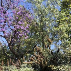
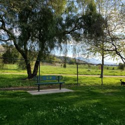
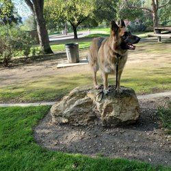
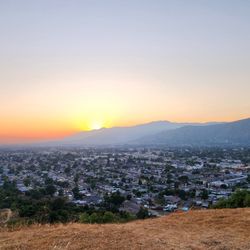
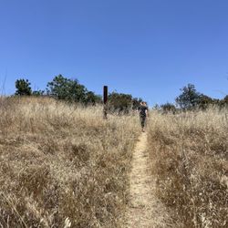
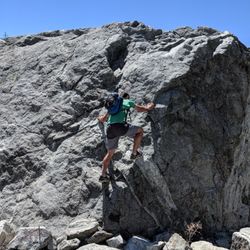
Michael D. Antonovich Trail Photos


You might also consider
More like Michael D. Antonovich Trail
Recommended Reviews - Michael D. Antonovich Trail
Start your review...

Reviews With Photos - Michael D. Antonovich Trail

M.D. Antonovich Trail is a ~7 mile out-and-back trail in San Dimas, CA. This trail has plenty of Poison Ivy and a very popular hiking spot, horse back riding, dog walking (off-leash), and mountain biking. It's considered a moderate hiking trail with an elevation gain of 416 feet and descends into a canyon then follows a stream. This trail has an of abundant tree shades and cool air emanating from the stream which you'll cross multiple streams. How Fun!! (I didn't fall or get wet) The south Antonovich trail connects to Walnut Creek trail and Sage trail. And then it loops back to the Antonovich trail. The creek is not the clearest of water and deemed unclean. And the best part was I encountered rabbits...lots of wabbits. Getting back was easy despite the lack of sign post but relied on my mental map. It took me roughly 2 hrs, 42 mins to complete the entire trail with a few stops to take photos. Parking lot has multiple entry points, (a) San Dimas Avenue, (b) Valley Ctr Staging Area, (c) Lyman Staging Area. Cell reception was good. Overall, I had a bloody good time, and thoroughly enjoyed this hiking spot and it's scenery. I recommend this trail.


I would definitely say its a 4.5 to 4.75 score during the rainy season - the creeks and water ways are so cool! During the dry season, it will be 4 to 4 25. Great parking at street level and on side. There are two extra points along the way, as you hike the 3.5 in you'll come across parking stations. Round trip is about 7miles to 7.5 miles Great for beginners to advanced. Great scenery and photo ops. Trails are curvy , steep and also flat. Multiple entry and exit points along trail. Hikes are perfect, picnic and rest areas are fantastic. Do visit when its raining, makes for some awesome workouts!. Area is inviting, trail is definitely well kept safe and clean. Bring groups, enjoy a wonderful trailhead. I believe pets in leash is okay... bikes are not. Chk website for more information.

If you're looking for a easy fun hiking trail for the family, especially with kids or dogs this is the one for you. It has plenty of shade and multiple water crossings. From beginning to end the entire trail is 3.86mi starting from near Bonelli park and ends at Schabarum park. Although the best parking spot is at parking lot A which is about 1mi into the trail. Search for "Hiking Valley Center Staging Area" on google map for exact address. It's right next to the Tzu Chi Buddhist temple. Make sure to take the trail path on the right side of the parking lot to head towards Schabarum park. If you go towards the temple the walk will only be about 1mi till reach Bonelli park lot. As mentioned there are ALOT of water crossings along this trail. You can walk through the creek if you want but you must cross somehow. It's fairly easy crossing since there are bolders to step over. Just be careful if you have really bad balance or small kids that may slip. The trail path does get very narrow in certain sections so you may need to let oncoming traffic pass. It does goes very busy during the weekends so the parking lots do get full especially the later you go. Parking is free in any of the lots. There are NO bathrooms anywhere on the trail until you reach Schabarum park. Note alot of the trail path signs are completely covered in graffiti so don't get lost going on a side trail. But its pretty obvious where the main trail direction is. Definitely a fun easy walk with almost zero elevation gain for all levels and animals alike.

Beautiful hiking trail in the San Dimas mountains. You'll find lots of vegetation and streams, making this 6+ mile (3+ miles up and back) hike feel serene and relaxing. Be prepared with extra socks and shoes as you will probably get wet walking through the streams. They are not too deep (ankle deep); just enough to get your shoes wet. Some portions are a little difficult (narrow, tree roots, streams) and other portions are flat and wide. Lots of shaded areas so you will feel some relief during the hot summer months. Overall, the path is easy to follow. Lots of social media worthy spots to take amazing pics. Trail is also dog friendly. This is a popular trail so it will be crowded at times. There are three parking areas along the route. The trail is straight so in order to return to where your car is parked, you will need to turn around and head back the same way you started.

(01/08/22) Easy hike at day time, but can get tricky without enough sun light. Though I had lots of fun hiking here this past weekend, a few days after the rain. The trail crosses the stream multiple times in zig-zag direction, so you can practiced your balance skills, or wear water-proof shoes and walk on the water. There's swings in the side, mosses in the rock right after the rain, many bunnies hiding in bushes, and so many many birds chirping! You gotta learn to enjoy the sound of nature, if you can't hear it, stand still and close your eyes. - IN CASE YOU WANT TO HIKE AT NIGHT, DON'T! The one thing to keep in mind is to finish the hike before sundown since sunset very quickly during winter time. We almost got lost after the dark because it was hard to see the rock to cross through the stream and not sure if there's a trail on the other side of the stream or not since the trail crosses the stream back back and forth, so at one point I almost cousins find the trail when we couldn't see the path by the stream at night. Luckily, our phone flashlight kind of help to see the stream. But still a bit worried since it's super dark and we're aware that animals come out at night. Overall, it's still a really enjoyable hike for us. The whole hike took us around 3 hours. Definitely recommend coming early of the day and not stay pass sunset. Although we had fun searching for the trail in the dark, not a good idea to stay late again. But we'll come back for more day time hikes!

This is a great family hike with dogs or without. We usually always park at the top mountain parking on San Dimas Blvd. But on weekends it's a bit harder to park here. You can also park in the other larger parking lot that is next to the Temple. However, if you do, you're 1/3 into the hike already. Most of the hike is shaded and pretty flat except when you are traversing down from the mountain top parking. You do cross several streams on the hike but there are rocks strategically placed so you can cross. I would recommend hiking sticks for older hikers. I usually do go off the trail by accident by always end up back on the correct path, thanks to the AllTrails App. I see that there are a lot of complaints about graffiti and the smell. So yes at some locations there is graffiti, but it's ignorable. The smell comes from the sewer manhole covers starting around 1/2 way through the hike. It's more noticeable when it's hot out. Oh and also watch out the tons of poison oak.

Great trail that took about 2 hours total in and out with some shaded areas and quite a bit of water crossings. Due to the very little parking , we were able to bike to the trailhead from La Verne which I recommend and is doable. There are no bike racks but parking it to a rail sufficed. Can be busy on weekends. Highly recommend this place!

Oasis of forested trails in the midst of suburbia makes this perfect for a mid-week outing. Come early to get parking if you're parking off of San Dimas Avenue. Once you descend into the valley from the San Dimas Avenue parking lot, the trail is a heavily shaded walk with intermittent creek crossings and features a few swarming bee hives, a pair of mallard ducks, random swings on random trees and a host of other visitors that are also on the trail with you. Wear hiking sandals if you don't like soggy shoes. One star off for maintenance. There are graffiti art on the trail signs and on some boulders and trees and the wrought iron fence separating the trail from the residential area has collapsed in some areas.


An easier meandering trail that follows a stream as it winds through San Dimas. The trail has lots of shade, and if you come in the evening be prepared to see lots of birds and rabbits frolicking along the trail. If you're looking for an intense workout, this trail won't help you mutch, but if you like a great scenic stroll, this one is hard to beat in the area. Make sure to watch out for Poison Oak, as there is a ton growing along the trail.

Such a fun trail for kids! Lots of shade too! Kids favorite parts are crossing the stream and the swings that are randomly placed on branches. Parking on San Dimas ave gets a bit busy even during the week. Try to park by the Buddhist temple. Overall, the hike is easy to moderate. Just be careful of poison oaks! They're everywhere! Stay on the trail!


9 months ago
Found Cell Phone: Samsung. Found on October 15th at 4pm. Trail Review: Loved the trail. Not too hard but challenging enough. Love that there is shade and not too crowded. read more

1 year ago
M.D. Antonovich Trail is a ~7 mile out-and-back trail in San Dimas, CA. This trail has plenty of Poison Ivy and a very popular hiking spot, horse back riding, dog walking (off-leash), and mountain biking. It's considered a moderate hiking trail with an elevation gain of 416 feet and descends into a canyon then follows a stream. This trail has an of abundant tree shades and cool air emanating from the stream which you'll cross multiple streams. How Fun!! (I didn't fall or get wet) The south Antonovich trail connects to Walnut Creek trail and Sage trail. And then it loops back to the Antonovich trail. The creek is not the clearest of water and deemed unclean. And the best part was I encountered rabbits...lots of wabbits. Getting back was easy despite the lack of sign post but relied on my mental map. It took me roughly 2 hrs, 42 mins to complete the entire trail with a few stops to take photos. Parking lot has multiple entry points, (a) San Dimas Avenue, (b) Valley Ctr Staging Area, (c) Lyman Staging Area. Cell reception was good. Overall, I had a bloody good time, and thoroughly enjoyed this hiking spot and it's scenery. I recommend this trail. read more

1 year ago
Love to take my dogs here for a hike. They love it too. Trail switches back and forth across streams. Lots of trees. read more


10 months ago
2 years ago
I would definitely say its a 4.5 to 4.75 score during the rainy season - the creeks and water ways are so cool! During the dry season, it will be 4 to 4 25. Great parking at street level and on side. There are two extra points along the way, as you hike the 3.5 in you'll come across parking stations. Round trip is about 7miles to 7.5 miles Great for beginners to advanced. Great scenery and photo ops. Trails are curvy , steep and also flat. Multiple entry and exit points along trail. Hikes are perfect, picnic and rest areas are fantastic. Do visit when its raining, makes for some awesome workouts!. Area is inviting, trail is definitely well kept safe and clean. Bring groups, enjoy a wonderful trailhead. I believe pets in leash is okay... bikes are not. Chk website for more information. read more


If you're looking for a easy fun hiking trail for the family, especially with kids or dogs this is the one for you. It has plenty of shade and multiple water crossings. From beginning to end the entire trail is 3.86mi starting from near Bonelli park and ends at Schabarum park. Although the best parking spot is at parking lot A which is about 1mi into the trail. Search for "Hiking Valley Center Staging Area" on google map for exact address. It's right next to the Tzu Chi Buddhist temple. Make sure to take the trail path on the right side of the parking lot to head towards Schabarum park. If you go towards the temple the walk will only be about 1mi till reach Bonelli park lot. As mentioned there are ALOT of water crossings along this trail. You can walk through the creek if you want but you must cross somehow. It's fairly easy crossing since there are bolders to step over. Just be careful if you have really bad balance or small kids that may slip. The trail path does get very narrow in certain sections so you may need to let oncoming traffic pass. It does goes very busy during the weekends so the parking lots do get full especially the later you go. Parking is free in any of the lots. There are NO bathrooms anywhere on the trail until you reach Schabarum park. Note alot of the trail path signs are completely covered in graffiti so don't get lost going on a side trail. But its pretty obvious where the main trail direction is. Definitely a fun easy walk with almost zero elevation gain for all levels and animals alike. read more


1 year ago
5 years ago
Beautiful hiking trail in the San Dimas mountains. You'll find lots of vegetation and streams, making this 6+ mile (3+ miles up and back) hike feel serene and relaxing. Be prepared with extra socks and shoes as you will probably get wet walking through the streams. They are not too deep (ankle deep); just enough to get your shoes wet. Some portions are a little difficult (narrow, tree roots, streams) and other portions are flat and wide. Lots of shaded areas so you will feel some relief during the hot summer months. Overall, the path is easy to follow. Lots of social media worthy spots to take amazing pics. Trail is also dog friendly. This is a popular trail so it will be crowded at times. There are three parking areas along the route. The trail is straight so in order to return to where your car is parked, you will need to turn around and head back the same way you started. read more


4 years ago
(01/08/22) Easy hike at day time, but can get tricky without enough sun light. Though I had lots of fun hiking here this past weekend, a few days after the rain. The trail crosses the stream multiple times in zig-zag direction, so you can practiced your balance skills, or wear water-proof shoes and walk on the water. There's swings in the side, mosses in the rock right after the rain, many bunnies hiding in bushes, and so many many birds chirping! You gotta learn to enjoy the sound of nature, if you can't hear it, stand still and close your eyes. - IN CASE YOU WANT TO HIKE AT NIGHT, DON'T! The one thing to keep in mind is to finish the hike before sundown since sunset very quickly during winter time. We almost got lost after the dark because it was hard to see the rock to cross through the stream and not sure if there's a trail on the other side of the stream or not since the trail crosses the stream back back and forth, so at one point I almost cousins find the trail when we couldn't see the path by the stream at night. Luckily, our phone flashlight kind of help to see the stream. But still a bit worried since it's super dark and we're aware that animals come out at night. Overall, it's still a really enjoyable hike for us. The whole hike took us around 3 hours. Definitely recommend coming early of the day and not stay pass sunset. Although we had fun searching for the trail in the dark, not a good idea to stay late again. But we'll come back for more day time hikes! read more


 - Hiking Near Me - San Dimas, California")
4 years ago
This is a great family hike with dogs or without. We usually always park at the top mountain parking on San Dimas Blvd. But on weekends it's a bit harder to park here. You can also park in the other larger parking lot that is next to the Temple. However, if you do, you're 1/3 into the hike already. Most of the hike is shaded and pretty flat except when you are traversing down from the mountain top parking. You do cross several streams on the hike but there are rocks strategically placed so you can cross. I would recommend hiking sticks for older hikers. I usually do go off the trail by accident by always end up back on the correct path, thanks to the AllTrails App. I see that there are a lot of complaints about graffiti and the smell. So yes at some locations there is graffiti, but it's ignorable. The smell comes from the sewer manhole covers starting around 1/2 way through the hike. It's more noticeable when it's hot out. Oh and also watch out the tons of poison oak. read more


1 year ago
Great trail that took about 2 hours total in and out with some shaded areas and quite a bit of water crossings. Due to the very little parking , we were able to bike to the trailhead from La Verne which I recommend and is doable. There are no bike racks but parking it to a rail sufficed. Can be busy on weekends. Highly recommend this place! read more


Oasis of forested trails in the midst of suburbia makes this perfect for a mid-week outing. Come early to get parking if you're parking off of San Dimas Avenue. Once you descend into the valley from the San Dimas Avenue parking lot, the trail is a heavily shaded walk with intermittent creek crossings and features a few swarming bee hives, a pair of mallard ducks, random swings on random trees and a host of other visitors that are also on the trail with you. Wear hiking sandals if you don't like soggy shoes. One star off for maintenance. There are graffiti art on the trail signs and on some boulders and trees and the wrought iron fence separating the trail from the residential area has collapsed in some areas. read more


This is a fairly easy trail with plenty of shade and streams along the way. It's unfortunate we witnessed graffiti on Mother Nature's trees and rock formations. The trail was not crowded at all given it was a Tuesday. I'll be back to explore further. read more


1 year ago
An easier meandering trail that follows a stream as it winds through San Dimas. The trail has lots of shade, and if you come in the evening be prepared to see lots of birds and rabbits frolicking along the trail. If you're looking for an intense workout, this trail won't help you mutch, but if you like a great scenic stroll, this one is hard to beat in the area. Make sure to watch out for Poison Oak, as there is a ton growing along the trail. read more


6 years ago
Such a fun trail for kids! Lots of shade too! Kids favorite parts are crossing the stream and the swings that are randomly placed on branches. Parking on San Dimas ave gets a bit busy even during the week. Try to park by the Buddhist temple. Overall, the hike is easy to moderate. Just be careful of poison oaks! They're everywhere! Stay on the trail! read more


3 years ago
Loved this trail! Very peaceful, lots of shade, family and pet friendly, and wasn't too busy on a Sunday morning. Will definitely be back here! read more


6 years ago
Favorite trail in the area. Love the shade and water running along the trail and also the small bits of creek you need to hop over. It doesn't feel at all like other dry brush trails in the area with it descending into trees from the trailhead. But go at your caution this weekend or in May. Easily saw 50 people, many kids, their dogs and their poos, horses and poo, who all had the same idea. And more trash than usual and masks on the ground, in plants :(. Please pack your trash out so we can all enjoy this trail. Someone crossed out the need to wear face coverings on the sign at trailhead/stops! Parking was hard; small lot was full and cars parked to the overpass. It was a little mad for a usual weekend. read more


4 years ago
Came in for a hot summer hiking day with my dogs and my other half. Area was nice and shaded.There were some streams that needed to be crossed.Very refreshing especially to my dogs.Theres a bit of a creepy vibe to the trail as it is quite inclusive.I definitely wont be hiking this when it is dark and dawn. read more


The parking lots were very difficult to find. I ended up parking at the parking lot right off of the freeway. I would rate this trail a moderate hike. There are a lot of hills so brace yourself! If you're looking for a "reward" like a waterfall, this is not the trail for you. It just leads to parking lots in between and a lot of nature. The markings for the trail were confusing so we ended up going off trail several times and then finding the trail again. There weren't very many people here on the trail is wide in most areas so you can maintain distance and there are streams as well. Your shoes will get wet. Most of the rocks I stepped on to walk across the streams were unstable. Overall, I got quite the workout with all the hills. I do suggest wearing appropriate hiking shoes when on this trail. read more


I live here for almost 1 year 9 months and did not know about it? This is a very short 1 mile trail. (2 miles round trip). oh well, I found this trail extended east from the parking lot at 1100 Valley center ave today!!! haven't had enough time to explore how far that side goes. Difficulty: Easy to moderate. You can start at either west or east entrance. West: Starts at 1100 Valley Center ave (near the Buddhist Tzu Foundation, the parking is just few feet outside their gate) East: On S San Dimas Ave. After you pass under the 57 fwy, the parking is on your right side. If you start from the west, follow the trail sign and just few feet you will have to across the street (Valley Ctr Ave) to continue the hike. What I really like about this place is lot of shades. Even on a 93 degree summer afternoon it was bearable. If you start from the west, approx at 0.7 mile you will start have more incline (steep) and less shades before you reach S San Dimas Ave. It actually hurt my knee a little bit on my way back down. There are approx 4 river crossing (more like creek) and I just can't believe I slide on the rock and got my feet wet. What I do NOT like is you lose cellular signal (Verizon) once you start the trail. The cellular signal only available at the beginning and end. It matches my requirement for a quick workout, short and with lot of shades. and...not too far from civilization. read more


3.5 stars! PERFECT trail for a hot day because it's very shaded throughout! it's also the ideal trail if you want to go trail running on a relatively flat path (the only real incline we encountered was at the start which you will walk/run back up at the end) i really liked the scenery since it was very green and there was water. LOT's of stream crossings, so be careful not to get wet! the one thing i did not appreciate about this trial was the number of gnat clouds we ran through, hard to dodge them when you're running fast and don't see them until the last second. ALSO sometimes it wasn't clear where the trial was going since there were multiple random ones NOTE: there's a rope hanging from a tree if you want to take a swing! read more

2 years ago
6 years ago
This trail is one our family's favorite hiking spots. It has lots of shade and there are many places where you will need to cross the creek. Our kids love crossing the creek. Wear shoes you don't care to get messed up. This trail is popular for horse riding and people walking their dogs, so watch out for . The trail starts at a parking lot beside the 57 freeway but if you park there you will have a steep hill to climb when you return. We like to park near the temple and then we head west. From there you will pass a swing and traverse the creek multiple times. Brink snacks and water and take a break at another parking lot along the way. No restrooms or drinking water at any of the parking lots. read more


6 years ago
Recently moved back but had never explored any trails. Now that I'm a dog owner I've gotten very into trails but hadn't found any yet. My friend introduced me to this trial and I loved it! I will definitely be back! I would definitely recommend pants and actual hiking boots to cross the streams as the rocks can be very slippery. If you plan on bringing your pets I recommend bringing baby wipes to wipe off their paws when you're done as well. Depending on the time I would also be sure you have a flashlight. The area is pretty shaded so I actually didn't need my sunglasses as much. read more


5 years ago
Watch out for poison oak! I saw rabbits and squirrels. There were fun creek crossings. It's an easy hike. read more

5 years ago
Loved the hike, very easy trail but their is little creeks you must go over in order to get on the other side( that's if you stay along the water). It was a bit muddy when we went (Jan 31), since it had been raining days before that. Tons of space! Lots of families enjoying the outdoors but don't even notice them, really enjoyed it, deff recommend it. If you go by the .25 mark to the right their is a hidden trail and their is a hidden bench swing . read more


By far one of the best trails I have been to. It's nestled in between the 57 and the 210 freeway and you would never expect it. It's covered with creeks. Lots of greenery and of the most scenic hikes I've been to in awhile. I absolutely love it. read more


6 years ago
Beautiful hike. It's goes down a few hundred feet. Lots of beautiful wooded scenery for taking photos. Gorgeous trees with undulating branches. A good portion of the hike is along Walnut Creek, you do need to cross over multiple times with pebble crossings, so do not hike in your favorite shoes. I do think the hike is a little more difficult that some posters. But it is a great place to get some basic skills and balance. read more


4 years ago
4 years ago
7 years ago
I've been coming here for years. It's convenient as I live locally and has a lot of shade. I will warn you though to be very cautious when hiking. It seems like lately more people are coming with a sketchy agenda. Just be very aware of your surroundings and have a hiking buddy and possibly some pepper spray. read more


Page 1 of 3
More info about Michael D. Antonovich Trail
822-1098 S Ave
San Dimas, CA 91773
Directions
Hours
Outdoor Amenities
Ask the Community - Michael D. Antonovich Trail
Hi there :) Does anyone know if there's any signs around the trails that warn people of the poison oak ? I'm planning on taking my kids tomorrow and want to avoid my kids…
No there is only one sign at the beginning to warn of poison oak none on the trail
Is there another parking area besides off of san dimas ave?
yes, theres 2 other parking areas.
Is it open again? I've gone twice now and it's been closed off still. Anyone know if the trail is open?
Yes is is open
Is here dog friendly? for dog hiking?
Yes it is. Seen many people with dogs on the trail.
What are the open and close hours of this trail?
Review Highlights - Michael D. Antonovich Trail
You might also consider


Why does Yelp recommend reviews?
2 reviews that are not currently recommended
The reviews below are not factored into the business's overall star rating.
11 years ago
9 years ago
Michael D. Antonovich Trail - hiking - Updated July 2026
Best of San Dimas
People found Michael D. Antonovich Trail by searching for…
Hiking Trails in San Dimas, CA
Beautiful Views in San Dimas, CA
Places to Take Pictures in San Dimas, CA
Waterfall Hike in San Dimas, CA
Walking Trails in San Dimas, CA
Stairs Workout in San Dimas, CA
Running Trails in San Dimas, CA
Things to Do With Kids in San Dimas, CA
Off Road Trails in San Dimas, CA
Scenic Overlook in San Dimas, CA
Trending Searches in San Dimas, CA
Black Owned Nail Salons in San Dimas, CA
Cliff Jumping in San Dimas, CA
Jet Ski Rental in San Dimas, CA
Lakes & Ponds in San Dimas, CA
Off Road Trails in San Dimas, CA
Outdoor Activities in San Dimas, CA
Places To Swim in San Dimas, CA
Places To Walk Around in San Dimas, CA
Pool Day Pass in San Dimas, CA
Public Shower in San Dimas, CA
River Swimming in San Dimas, CA
Running Trails in San Dimas, CA
Scenic Night View in San Dimas, CA
Scenic Overlook in San Dimas, CA
Swimming Holes in San Dimas, CA
Browse Articles
Browse Nearby
BEST of San Dimas, California Coffee near Michael D. Antonovich Trail
BEST of San Dimas, California Restaurants near Michael D. Antonovich Trail
BEST of San Dimas, California Things to Do near Michael D. Antonovich Trail
BEST of San Dimas, California Breakfast near Michael D. Antonovich Trail
BEST of San Dimas, California Parks near Michael D. Antonovich Trail
BEST of San Dimas, California Walking Trails near Michael D. Antonovich Trail
BEST of San Dimas, California Campgrounds near Michael D. Antonovich Trail
BEST of San Dimas, California Hot Springs near Michael D. Antonovich Trail
BEST of San Dimas, California Snow Tubing near Michael D. Antonovich Trail
Browse Brands
Related Searches in San Dimas, CA
Best Fishing Locations and Guides in San Dimas, California
Best Nature Trails for Hiking in San Dimas, California
Best Places for Horseback Riding in San Dimas, California
Best Waterfalls and Swimming Holes in San Dimas, California
Check Out Off Road Trails in San Dimas, California
Discover Dog Friendly Trails to Explore in San Dimas, California
Discover Kid Friendly Hiking Trails in San Dimas, California
Discover Scenic Hiking Trails in San Dimas, California
Discover Scenic Mountain Bike Trails Near San Dimas, California
Discover Scenic Waterfall Spots in San Dimas, California
Discover Walking Parks in San Dimas, California Near You
Discover a Hiking Trail in San Dimas, California
Discover the Best Night Hike Trails in San Dimas, California
Discover the Best Running Track in San Dimas, California
Dog-Friendly Hikes With Dogs in San Dimas, California
Enjoy Camping Adventures Around San Dimas, California
Enjoy Exciting Mountain Biking Adventures in San Dimas, California
Enjoy Kayaking Adventures in San Dimas, California
Enjoy Tent Camping Spots Around San Dimas, California
Enjoy a Beautiful Waterfall Hike in San Dimas, California
Enjoy a Peaceful Nature Walk in San Dimas, California
Enjoy the Best Walking Path in San Dimas, California
Enjoy the Best Walking Trails in San Dimas, California
Exciting Cliff Jumping Spots in San Dimas, California
Explore Beautiful Parks and Green Spaces in San Dimas, California
Explore Easy Hikes Perfect for All in San Dimas, California
Explore Fun Activities to Do in San Dimas, California
Explore Popular Campgrounds Near San Dimas, California
Explore the Best Beach Spots in San Dimas, California
Explore the Best Trail Options in San Dimas, California
Family Friendly Hiking With Kids in San Dimas, California
Find Beautiful Views in San Dimas, California
Find the Best Parks for Picnics in San Dimas, California
Find the Best Scenic View Locations in San Dimas, California
Great Places to Walk in San Dimas, California
Hike the Popular Waterfall Trail in San Dimas, California
Hiking Trails With Waterfalls in San Dimas, California
Off Leash Dog Hiking Trails in San Dimas, California
Plan a Scenic Drive Route Near San Dimas, California
Popular Outdoor Activities to Try in San Dimas, California
Popular Picnic Spots to Visit in San Dimas, California
Safe River Swimming Areas in San Dimas, California
Safe and Fun Parks for Kids in San Dimas, California
Top Climbing Spots and Gyms in San Dimas, California
Top Paddleboarding Activities in San Dimas, California
Top Running Trails to Explore in San Dimas, California
Top Swimming Lakes to Enjoy in San Dimas, California
Top Swimming Spots and Pools in San Dimas, California