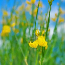
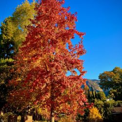
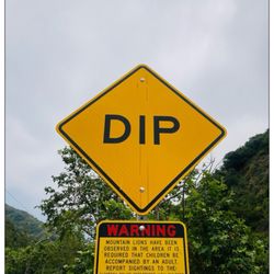
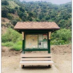
Mt. Bliss Photos


You might also consider
More like Mt. Bliss
Recommended Reviews - Mt. Bliss
Start your review...

Reviews With Photos - Mt. Bliss

From an experienced hiker point of view, this is not an easy hike. The hike is just over 10 miles round-trip. The first 4 miles is all upward incline. I am not trying to deter anyone from completing. For those who like a challenging hike, this is for you. Once you get up there, it is nice and quiet. The views are impressive with chaparral-cloaked land of steep ridges and sand stone canyons. It gets a bit confusing at the end with no signage to guide. Come prepared with water and most of the hike (fire road) is exposed, with plenty of sun.

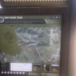
Pretty epic trails the leads straight to the top. The actual trail itself is called Van Tassel. Limited little parking lot for about 10 cars with a 3 hour limit, which is kind of whack because it takes longer than that to get to the top and down. Great views of the area. You can see DTLA from a viewpoint about a fifth of the way up.
Once you reach the top of the mountain please take a deep breath for me. One for the beauty and one for the exhausted legs after all that uphill battle. Such a challenge in my opinion constant inclines and very tough on the legs. I encourage everyone to dominate this place and don't be discouraged. One step after another.

If you're thinking of hiking up to Mt Bliss this time of year, be prepared for rain and wind! My friend and I attempted the trail via Van Tassel Fire Road last weekend, and while the first hour of the hike was uneventful weather-wise, the fog and heavy grey clouds came rolling in pretty quickly. Unless you like being soaked, it's a good idea to bring gloves and a warm, waterproof jacket with a hood (which neither my friend nor I had the foresight to do). While this isn't the most scenic of trails (you are on a fire road, after all), it's definitely a workout for your thighs, calves, butt....everywhere, really. The trail is a constant steep incline on the way up, which makes it tough on your knees on the way down. (Take caution especially during the rainy season, since it's easy to slip on mud and loose rocks here.) We aimed to complete the full 8.6 miles round trip (2880 ft elevation gain), but when we were nearing the end of the fourth mile up, the rain started coming down and the fog was so thick we couldn't see more than 10 feet ahead of us. There was a fork in the road and we weren't exactly sure which one to take. Obviously, trying to spot landmarks was a no-go at this point, so we ended up turning back. The only upside was that I was able to take a few neat photos of the dark, fog-encased hills -- they make Mt Bliss look a little more like Sleepy Hollow! Note on parking: you can park on the side of the road or in one of the empty dirt lots right off of Encanto Parkway. You then start the hike at the side road that leads to the Encanto Equestrian Center. After you walk past the stables, the road ends and you'll see the start of the trail leading up into the hills. For more details of the hike, this page is pretty helpful: http://www.simpsoncity.com/hiking/bliss.html

Did the hike today... wasn't really expecting this hard of a hike but we did it! Got there around 1:30PM. Probably would go earlier than that next time. Followed the directions from http://www.simpsoncity.com/hiking/bliss.html Immediately started the hike. Took us about 2.5 hours to get up there after taking a few rest stops. It is ALL up hill and pretty steep. So be weary, this isn't a first time hikers hike. It is a fire road... pretty well maintained and very easy to follow. You won't get lost. As you're hiking up, don't forget to turn around and enjoy the views, but they don't compare to the view up top. Pretty much a 270* view of the surrounding city, and the rest of it is of the mountains behind, VERY beautiful view. Got back down in 1.5 hours, as it was getting dark and we were getting kind of tired and wanted to bust it all out. Great hike, be in decent shape. Sign the guest book up top as not many visitors actually get up there! Be proud :)


Not sure where mt bliss was. Decided to just walk the entire fire road til the end but turned around at 6.1 miles. It started to descend and the rain was coming in. I'm guessing if you walk til the end of the road, it would be around 9-10 miles.Hike ended at 12 miles round trip and 3,421 ft climbed. Took me a little under 4 hours.

Awesome workout!!! This hike is slightly over 8 miles roundtrip. It's a little hard to locate, which allows for a nice lonely trail. I recently did this trail with 5 other people, and it took us a little under 4 hours. The notebook at the very top was a little difficult to locate since the trail seems to split in 3 different directions. The majority of the trail is open with no shade, so be prepared to encounter some heat. On a clear day you can see all the way to the ocean. I would do this trail more often, but coming back down was hard on my knees.
")
I liked Mt Bliss. Yes, it is just a fire road and steep hill. But, it was really quiet, and I could enjoy nice scenery of towns. And, of course great workout. I needed to make my dog tired. She was really enjoying, while I was being worn out :p I will definitely come back! I found bear tracks on the trail. So, be prepared for wild life :)

This is the trail if you're looking for a crazy non stop incline. The entire trail is a 11 mile round trip. There are some parts that are gravelly. Be very careful to avoid injury. Should wear hiking shoes with traction. There's no shade so make sure you bring a hat and wear lots of sunscreen. Insect spray and net are high recommended. You will see army of Gnats flying everywhere. You will hit 3500+ elevation and it's a great trail for if you want to build that leg muscle and burn more calories. Pretty straight forward trail just one way up you will see a split when you're near the top. Make sure you make a right and a quick left if you're going towards mount bliss. Parking: I usually park at Encanto Park and walk towards the trail, about half a mile down. read more


2 years ago
Great hike since the beginning straight to business I would recommend to try this hike bring lots of water read more


5 years ago
From an experienced hiker point of view, this is not an easy hike. The hike is just over 10 miles round-trip. The first 4 miles is all upward incline. I am not trying to deter anyone from completing. For those who like a challenging hike, this is for you. Once you get up there, it is nice and quiet. The views are impressive with chaparral-cloaked land of steep ridges and sand stone canyons. It gets a bit confusing at the end with no signage to guide. Come prepared with water and most of the hike (fire road) is exposed, with plenty of sun. read more


6 years ago
Pretty epic trails the leads straight to the top. The actual trail itself is called Van Tassel. Limited little parking lot for about 10 cars with a 3 hour limit, which is kind of whack because it takes longer than that to get to the top and down. Great views of the area. You can see DTLA from a viewpoint about a fifth of the way up. read more


6 years ago
Once you reach the top of the mountain please take a deep breath for me. One for the beauty and one for the exhausted legs after all that uphill battle. Such a challenge in my opinion constant inclines and very tough on the legs. I encourage everyone to dominate this place and don't be discouraged. One step after another. read more


14 years ago
If you're thinking of hiking up to Mt Bliss this time of year, be prepared for rain and wind! My friend and I attempted the trail via Van Tassel Fire Road last weekend, and while the first hour of the hike was uneventful weather-wise, the fog and heavy grey clouds came rolling in pretty quickly. Unless you like being soaked, it's a good idea to bring gloves and a warm, waterproof jacket with a hood (which neither my friend nor I had the foresight to do). While this isn't the most scenic of trails (you are on a fire road, after all), it's definitely a workout for your thighs, calves, butt....everywhere, really. The trail is a constant steep incline on the way up, which makes it tough on your knees on the way down. (Take caution especially during the rainy season, since it's easy to slip on mud and loose rocks here.) We aimed to complete the full 8.6 miles round trip (2880 ft elevation gain), but when we were nearing the end of the fourth mile up, the rain started coming down and the fog was so thick we couldn't see more than 10 feet ahead of us. There was a fork in the road and we weren't exactly sure which one to take. Obviously, trying to spot landmarks was a no-go at this point, so we ended up turning back. The only upside was that I was able to take a few neat photos of the dark, fog-encased hills -- they make Mt Bliss look a little more like Sleepy Hollow! Note on parking: you can park on the side of the road or in one of the empty dirt lots right off of Encanto Parkway. You then start the hike at the side road that leads to the Encanto Equestrian Center. After you walk past the stables, the road ends and you'll see the start of the trail leading up into the hills. For more details of the hike, this page is pretty helpful: http://www.simpsoncity.com/hiking/bliss.html read more


12 years ago
6 years ago
8 years ago
17 years ago
13 years ago
Did the hike today... wasn't really expecting this hard of a hike but we did it! Got there around 1:30PM. Probably would go earlier than that next time. Followed the directions from http://www.simpsoncity.com/hiking/bliss.html Immediately started the hike. Took us about 2.5 hours to get up there after taking a few rest stops. It is ALL up hill and pretty steep. So be weary, this isn't a first time hikers hike. It is a fire road... pretty well maintained and very easy to follow. You won't get lost. As you're hiking up, don't forget to turn around and enjoy the views, but they don't compare to the view up top. Pretty much a 270* view of the surrounding city, and the rest of it is of the mountains behind, VERY beautiful view. Got back down in 1.5 hours, as it was getting dark and we were getting kind of tired and wanted to bust it all out. Great hike, be in decent shape. Sign the guest book up top as not many visitors actually get up there! Be proud :) read more


11 years ago
This hike was no joke it was 4.3 miles straight up and 4.3 miles straight down this hike is not a beginners hike just an fyi but rewarding once you make it to the top. I was excited i got to finally take a pic of a snake read more


12 years ago
Not sure where mt bliss was. Decided to just walk the entire fire road til the end but turned around at 6.1 miles. It started to descend and the rain was coming in. I'm guessing if you walk til the end of the road, it would be around 9-10 miles.Hike ended at 12 miles round trip and 3,421 ft climbed. Took me a little under 4 hours. read more


11 years ago
Awesome workout!!! This hike is slightly over 8 miles roundtrip. It's a little hard to locate, which allows for a nice lonely trail. I recently did this trail with 5 other people, and it took us a little under 4 hours. The notebook at the very top was a little difficult to locate since the trail seems to split in 3 different directions. The majority of the trail is open with no shade, so be prepared to encounter some heat. On a clear day you can see all the way to the ocean. I would do this trail more often, but coming back down was hard on my knees. read more

10 years ago
I liked Mt Bliss. Yes, it is just a fire road and steep hill. But, it was really quiet, and I could enjoy nice scenery of towns. And, of course great workout. I needed to make my dog tired. She was really enjoying, while I was being worn out :p I will definitely come back! I found bear tracks on the trail. So, be prepared for wild life :) read more
 - Hiking Near Me - Duarte, California")
12 years ago
12 years ago
This Hike I loved one of my favorites. MT. Bliss is an 8 mile trip to the top. Wide road all dirt. Zig zag, switch backs and steep hill. Such a great view of the cities. read more

12 years ago
12 years ago
More info about Mt. Bliss
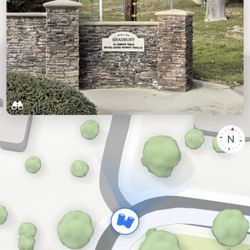
3737 Encanto Pkwy
Duarte, CA 91010
Directions
Hours
Outdoor Amenities
Ask the Community - Mt. Bliss
Review Highlights - Mt. Bliss
You might also consider


Why does Yelp recommend reviews?
1 review that is not currently recommended
The reviews below are not factored into the business's overall star rating.
10 years ago
Mt. Bliss - hiking - Updated July 2026
Best of Duarte
People found Mt. Bliss by searching for…
Trending Searches in Duarte, CA
Browse Articles
Browse Nearby
BEST of Duarte, California Things to Do near Mt. Bliss
BEST of Duarte, California Coffee near Mt. Bliss
BEST of Duarte, California Restaurants near Mt. Bliss
BEST of Duarte, California Lakes near Mt. Bliss
BEST of Duarte, California Parks near Mt. Bliss
Browse Brands
Related Searches in Duarte, CA
Best Fishing Locations and Guides in Duarte, California
Best Nature Trails for Hiking in Duarte, California
Best Places for Horseback Riding in Duarte, California
Best Waterfalls and Swimming Holes in Duarte, California
Check Out Off Road Trails in Duarte, California
Discover Dog Friendly Trails to Explore in Duarte, California
Discover Kid Friendly Hiking Trails in Duarte, California
Discover Scenic Hiking Trails in Duarte, California
Discover Scenic Mountain Bike Trails Near Duarte, California
Discover Scenic Waterfall Spots in Duarte, California
Discover Top Nature Parks to Visit in Duarte, California
Discover Walking Parks in Duarte, California Near You
Discover a Hiking Trail in Duarte, California
Discover the Best Night Hike Trails in Duarte, California
Discover the Best Running Track in Duarte, California
Dog-Friendly Hikes With Dogs in Duarte, California
Enjoy Camping Adventures Around Duarte, California
Enjoy Exciting Mountain Biking Adventures in Duarte, California
Enjoy Kayaking Adventures in Duarte, California
Enjoy Tent Camping Spots Around Duarte, California
Enjoy a Beautiful Waterfall Hike in Duarte, California
Enjoy a Peaceful Nature Walk in Duarte, California
Enjoy the Best Walking Path in Duarte, California
Enjoy the Best Walking Trails in Duarte, California
Exciting Cliff Jumping Spots in Duarte, California
Explore Beautiful Parks and Green Spaces in Duarte, California
Explore Easy Hikes Perfect for All in Duarte, California
Explore Fun Activities to Do in Duarte, California
Explore Popular Campgrounds Near Duarte, California
Explore the Best Beach Spots in Duarte, California
Explore the Best Trail Options in Duarte, California
Family Friendly Hiking With Kids in Duarte, California
Find Beautiful Views in Duarte, California
Find the Best Parks for Picnics in Duarte, California
Find the Best Scenic View Locations in Duarte, California
Great Places to Walk in Duarte, California
Hike the Popular Waterfall Trail in Duarte, California
Hiking Trails With Waterfalls in Duarte, California
Off Leash Dog Hiking Trails in Duarte, California
Plan a Scenic Drive Route Near Duarte, California
Popular Outdoor Activities to Try in Duarte, California
Popular Picnic Spots to Visit in Duarte, California
Safe River Swimming Areas in Duarte, California
Safe and Fun Parks for Kids in Duarte, California
Top Climbing Spots and Gyms in Duarte, California
Top Running Trails to Explore in Duarte, California
Top Swimming Lakes to Enjoy in Duarte, California
Top Swimming Spots and Pools in Duarte, California