Hillside Wilderness Preserve Trail Hiking Photos

 - Hiking Near Me - Monrovia, California")
 - Hiking Near Me - Monrovia, California")

You might also consider
More like Hillside Wilderness Preserve Trail
Recommended Reviews - Hillside Wilderness Preserve Trail
Start your review...

Reviews With Photos

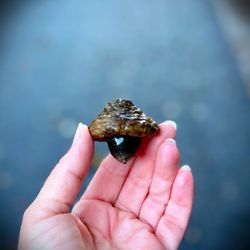
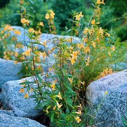
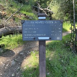
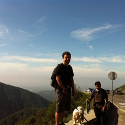
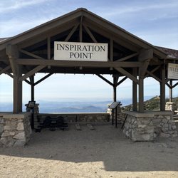
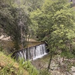
This hidden gem of a trail has been a fantastic alternative since the Monrovia Canyon Falls Trail has been closed. It's part of the Lower Clamshell peak that looms over Monrovia and the reward at the end of this lovely trail is dramatic, sweeping views of the entire San Gabriel Valley! It's a great trail anytime - but sunsets are especially magnificent here! The trial is across the neighborhood from Monrovia Canyon Park entrance. The trail itself is just over 2.5 miles out and back with just over 450 feet elevation gain. The incline is a decent workout and gradual so not a terrible butt burner lol. That being said - there's no parking at the trailhead. You have to park about a half mile down the hill OUTSIDE of the Oak Woods neighborhood along the street or you'll get a ticket. So this will add on 1/2 mile and over 220 feet elevation gain one way - for a total of 1 mile extra so be aware. It's all gravel and dirt once you get to the trailhead so it gets pretty muddy in any kind of rain. My last hike here was the day after all those crazy atmospheric river storms passed through and there were quite a few eroded areas and some places with landslide activity but nothing too crazy and the trail held up surprisingly well! The trail stays pretty busy but can still be peaceful at times and has tons of birding opportunities. A whole flock of gorgeous Cedar Waxwings were all over the trail last time bc the Toyon Trees are producing their berries right now which is one of their fave foods! Dogs are allowed and they provide doggie poop bags at the trailhead. Bikes are also allowed and the trails are fairly wide in most places so plenty of room for everyone. The trail is well marked with lots of signs and there's a bench at the top to enjoy the view and catch your breath. There's also a detailed sign and map at the trailhead. The trailhead can be misleading - it will look like you're walking up someone's private driveway at first but it's just a small local road and hikers are allowed. This is a neighborhood and residential area though so keep that in mind and be respectful bc you are walking right past people's houses.

Great quick hike up to "sunset bench" ... a little less than 3 miles round trip (2.67 miles). Entrance as others have mentioned is tricky to spot. Go up private looking drives with a few mailboxes out front. Brick pavers and a beautiful mid century modern home on the right is the entrance area. read more


Well maintained trail, it's a short hike with a steep uphill climb for a good part of it. It was a clear day so you can see all the way to DTLA! There's plenty of deer around so don't bother them and keep your distance. Parking on the street, be mindful of the neighborhood steet signs as the entrance to the trail is very suburban. read more


A few years ago, my ex took us here the first time and we love here so much! Very quiet, not crowded, beginner friendly and of coure the stunning view. Ever since then, this becomes my number one meditation spot on my day-off days! Highly recommended if you want a quick and easy hiking expertence withont burning your legs! read more


This hidden gem of a trail has been a fantastic alternative since the Monrovia Canyon Falls Trail has been closed. It's part of the Lower Clamshell peak that looms over Monrovia and the reward at the end of this lovely trail is dramatic, sweeping views of the entire San Gabriel Valley! It's a great trail anytime - but sunsets are especially magnificent here! The trial is across the neighborhood from Monrovia Canyon Park entrance. The trail itself is just over 2.5 miles out and back with just over 450 feet elevation gain. The incline is a decent workout and gradual so not a terrible butt burner lol. That being said - there's no parking at the trailhead. You have to park about a half mile down the hill OUTSIDE of the Oak Woods neighborhood along the street or you'll get a ticket. So this will add on 1/2 mile and over 220 feet elevation gain one way - for a total of 1 mile extra so be aware. It's all gravel and dirt once you get to the trailhead so it gets pretty muddy in any kind of rain. My last hike here was the day after all those crazy atmospheric river storms passed through and there were quite a few eroded areas and some places with landslide activity but nothing too crazy and the trail held up surprisingly well! The trail stays pretty busy but can still be peaceful at times and has tons of birding opportunities. A whole flock of gorgeous Cedar Waxwings were all over the trail last time bc the Toyon Trees are producing their berries right now which is one of their fave foods! Dogs are allowed and they provide doggie poop bags at the trailhead. Bikes are also allowed and the trails are fairly wide in most places so plenty of room for everyone. The trail is well marked with lots of signs and there's a bench at the top to enjoy the view and catch your breath. There's also a detailed sign and map at the trailhead. The trailhead can be misleading - it will look like you're walking up someone's private driveway at first but it's just a small local road and hikers are allowed. This is a neighborhood and residential area though so keep that in mind and be respectful bc you are walking right past people's houses. read more


Great, easy started hike with wide trails. It's in a neighborhood, walking up what feels like a driveway to find the gated entrance. Make sure to read the parking signs, we parked around the corner and all was good. It's a quick one, so extend it or hop aim another on if you are trying to get more miles in. Happy Munchies, @aVeganAndHer read more

More info about Hillside Wilderness Preserve Trail
889 Lower Clamshell Tktl
Monrovia, CA 91016
Directions
Hours
Indoor Amenities
Outdoor Amenities
You might also consider


Hillside Wilderness Preserve Trail - hiking - Updated May 2026
Best of Monrovia
People found Hillside Wilderness Preserve Trail by searching for…
Beautiful Views in Monrovia, CA
Walking Trails in Monrovia, CA
Running Trails in Monrovia, CA
Waterfall Hike in Monrovia, CA
Free Things to Do in Monrovia, CA
Dog Friendly Hiking Trails in Monrovia, CA
Places to Walk in Monrovia, CA
Places to Walk at Night in Monrovia, CA
Romantic Views in Monrovia, CA
Fun Things to Do at Night in Monrovia, CA
Trending Searches in Monrovia, CA
Boat Rental near Hillside Wilderness Preserve Trail
Botanical Gardens near Hillside Wilderness Preserve Trail
Bounce House Rentals near Hillside Wilderness Preserve Trail
Campgrounds near Hillside Wilderness Preserve Trail
Cherry Picking near Hillside Wilderness Preserve Trail
Cliff Jumping near Hillside Wilderness Preserve Trail
Dog Friendly Things To Do near Hillside Wilderness Preserve Trail
Flower Fields near Hillside Wilderness Preserve Trail
Flower Shop near Hillside Wilderness Preserve Trail
Garage Sales near Hillside Wilderness Preserve Trail
Hair near Hillside Wilderness Preserve Trail
Lakes & Ponds near Hillside Wilderness Preserve Trail
Nurseries & Gardening near Hillside Wilderness Preserve Trail
Outdoor Activities near Hillside Wilderness Preserve Trail
Outdoor Furniture Stores near Hillside Wilderness Preserve Trail
Parks near Hillside Wilderness Preserve Trail
Party Equipment Rentals near Hillside Wilderness Preserve Trail
Pedicure near Hillside Wilderness Preserve Trail
Pick Your Own Farms near Hillside Wilderness Preserve Trail
Picnic Areas near Hillside Wilderness Preserve Trail
Places To Take Pictures near Hillside Wilderness Preserve Trail
Running Trails near Hillside Wilderness Preserve Trail
Scenic Drive near Hillside Wilderness Preserve Trail
Secret Spots near Hillside Wilderness Preserve Trail
Strawberry Picking near Hillside Wilderness Preserve Trail
Sunrise View near Hillside Wilderness Preserve Trail
Swimming Holes near Hillside Wilderness Preserve Trail
Table And Chair Rentals near Hillside Wilderness Preserve Trail
Browse Articles
Browse Nearby
BEST of Monrovia, California Coffee near Hillside Wilderness Preserve Trail
BEST of Monrovia, California Things to Do near Hillside Wilderness Preserve Trail
BEST of Monrovia, California Walking Trails near Hillside Wilderness Preserve Trail
BEST of Monrovia, California Restaurants near Hillside Wilderness Preserve Trail
BEST of Monrovia, California Parks near Hillside Wilderness Preserve Trail
BEST of Monrovia, California Breakfast near Hillside Wilderness Preserve Trail
BEST of Monrovia, California Campgrounds near Hillside Wilderness Preserve Trail
BEST of Monrovia, California Hotels near Hillside Wilderness Preserve Trail
BEST of Monrovia, California Taxis near Hillside Wilderness Preserve Trail
Browse Brands
Related Searches in Monrovia, CA
Affordable Kayak Rental Services in Monrovia, California
Best Fishing Locations and Guides in Monrovia, California
Best Nature Trails for Hiking in Monrovia, California
Best Places for Horseback Riding in Monrovia, California
Check Out Off Road Trails in Monrovia, California
Discover Dog Friendly Trails to Explore in Monrovia, California
Discover Kid Friendly Hiking Trails in Monrovia, California
Discover Scenic Hiking Trails in Monrovia, California
Discover Scenic Mountain Bike Trails Near Monrovia, California
Discover Scenic Waterfall Spots in Monrovia, California
Discover Walking Parks in Monrovia, California Near You
Discover a Hiking Trail in Monrovia, California
Discover the Best Night Hike Trails in Monrovia, California
Discover the Best Running Track in Monrovia, California
Dog-Friendly Hikes With Dogs in Monrovia, California
Enjoy Camping Adventures Around Monrovia, California
Enjoy Exciting Mountain Biking Adventures in Monrovia, California
Enjoy Kayaking Adventures in Monrovia, California
Enjoy Tent Camping Spots Around Monrovia, California
Enjoy a Beautiful Waterfall Hike in Monrovia, California
Enjoy a Peaceful Nature Walk in Monrovia, California
Enjoy the Best Walking Path in Monrovia, California
Enjoy the Best Walking Trails in Monrovia, California
Exciting Cliff Jumping Spots in Monrovia, California
Explore Beautiful Parks and Green Spaces in Monrovia, California
Explore Easy Hikes Perfect for All in Monrovia, California
Explore Fun Activities to Do in Monrovia, California
Explore Popular Campgrounds Near Monrovia, California
Explore the Best Beach Spots in Monrovia, California
Explore the Best Trail Options in Monrovia, California
Family Friendly Hiking With Kids in Monrovia, California
Find Beautiful Views in Monrovia, California
Find the Best Parks for Picnics in Monrovia, California
Find the Best Scenic View Locations in Monrovia, California
Great Places to Walk in Monrovia, California
Hike the Popular Waterfall Trail in Monrovia, California
Hiking Trails With Waterfalls in Monrovia, California
Off Leash Dog Hiking Trails in Monrovia, California
Plan a Scenic Drive Route Near Monrovia, California
Popular Outdoor Activities to Try in Monrovia, California
Popular Picnic Spots to Visit in Monrovia, California
Safe River Swimming Areas in Monrovia, California
Safe and Fun Parks for Kids in Monrovia, California
Top Climbing Spots and Gyms in Monrovia, California
Top Paddleboarding Activities in Monrovia, California
Top Running Trails to Explore in Monrovia, California
Top Swimming Lakes to Enjoy in Monrovia, California
Top Swimming Spots and Pools in Monrovia, California
People who viewed Hillside Wilderness Preserve Trail also viewed
Duarte Recreational Trail
36 reviews
Santa Anita Canyon
84 reviews
Mt. Wilson Trail
303 reviews
Chantry Flat Recreation Area
276 reviews
Echo Mountain via the Sam Merrill Trail
458 reviews
Hermit Falls
298 reviews
Angeles National Forest
71 reviews
Sunset Ridge Trail
4 reviews
Toyon Trail
1 review
Henninger Flats Campground
98 reviews