Hoegee's Loop Trail Photos


You might also consider
More like Hoegee's Loop Trail
Recommended Reviews - Hoegee's Loop Trail
Start your review...

Reviews With Photos

Not our intended hike for the day. We were off to Hermit Falls and followed the little red Yelp marker to the general area that we thought it would be. We ended up at Chantry Flat, a parking lot, picnic, information area that serves as the beginning for several trails. We had already hiked at Sturtevant Falls so we did not want to do a repeat since we had done than one a couple of months ago. Instead, we found a marker that led to Hoegee's camp. I guess if I would have just read a couple of reviews I would have been alerted to the fact that we were only a couple of hundred feet away from the Hermit Falls trail. Next time I guess. The hike was great. A little under 2 hours. A 6 mile loop with great views and a couple of good hills. If you start the loop from the top of Chantry Flat, you have the pleasure of ending up at the bottom of the road. Anyone who has hiked around there knows the final incline from the bottom of the access road to the parking lot is a doozy. I forgot how much I didn't enjoy it the last time I climbed after hiking Sturtevant Falls. It'll humble you. The only thing I didn't like was the discarded water bottles along the trail. Take your trash with you!

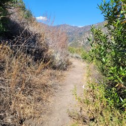
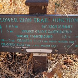
This hike is a 5 mile roundtrip loop with 1,000' elevation gain/loss. It is a fairly leisurely hike without much difficulty. Parts of it will get your heart rate going, but it's not difficult. The trail itself is mostly smooth dirt without loose rocks. Most of the way is single file. It is mostly shaded and is a peaceful wooded walk with lots of trees and streams to cross. The destination is Hoegee's Campground area. tip - if you want to make it a longer, more challenging hike: once you pass through the campground to continue on, you will see a sign (designating the Lower Zion Trail Junction) and a fork in the trail. If you go left, you will continue on Hoegee's Loop Trail. If you go right, then the hike will eventually take you past Sturtevant Falls (it's worth seeing) via the Gabrielino Trail and back to your starting point for a total of about a 10 mile hike. parking - small lot at Chantry Flats that requires an adventure pass

Without expecting too much, we headed out on our venture. Being very familiar with the falls at Chantry Flats, we decided to try something new and hit Hoegee's Loop. Given that it was a pretty warm and sunny day in the early hours of the morning, the choice was spot on perfect. The hike in total distance is just over 5miles round trip. I guess you could say that the descent into Big Santa Anita Canyon is my nemesis. Not going down, but ending a hike and having to come back up that treacherous hill. The great thing about this loop is that you start by heading down into the canyon and end up at the parking lot! You had me at "ending up at the parking lot". For those of you who have done this hike will understand. This is a primarily shady hike with wonderful scenery along the way. The trail is clean, well maintained, and lots of wonderful native plants in bloom during this time of year. The inclines are gradual with a total of approx 1,000 foot elevation gain. Once you hit Hoegee's Trail Camp, take a minute to look around. Some scattered foundation ruins of Hoegee's Camp are still intact. This is a campground with established fire pits, so a neat place to stop if you like backpacking. Hang your hammocks up between the lush trees and enjoy the silence of the forest. It's absolutely beautiful. From here you continue on to Upper Winter Creek Trail which will eventually drop you off at the parking lot. For this alone I was overwhelmed with joy! I can honestly say that this is my favorite hike at Chantry Flats. It is absolutely beautiful. The changes in scenery keep it interesting and fun. This is very doable for the whole family. Parking is crazy on the weekend, get there early or plan on parking an additional mile away in hopes of getting street parking which is very limited. Adventure pass is required and is available on site or at REI / Big 5 sporting goods. Bring lots of water, sunscreen, bug repellent, and a great attitude because this hike is a must do!

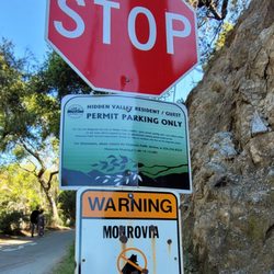
Relatively easy 5-mile loop that starts from Chantry Flats. I hiked starting at Upper Winter Creek--I think doing the loop the opposite way (starting at Lower Winter Creek) would be more of a workout, but I'll have to confirm that for you later. The trailhead is up behind the picnic area, attached to a paved road. It's a well-maintained, mstly-shaded trail, but definitely bring some bug repellent because although you can't SEE the creek from the water until you venture into the depths, the gnats are a-plenty wayyy before then. Note: I got there at 9:30am on a Sunday and had to park about a mile away, adding some unshaded trekking to that hike. So, you should be bringing sunscreen ANYWAY, but definitely pack it in if you're not getting there at the crack of dawn (Gates open at 6am). You need an Adventure Pass to park ANYWHERE in that area! If you don't have a yearly one (you can buy them at REI), I advise driving up to the ranger's station, stop in a 15-min spot and buy a $5 day pass, then driving BACK down to your parking spot. Unless, of course, you don't mind adding 2-4 miles of paved, car-occupied road to your hike. UP TO YOU.

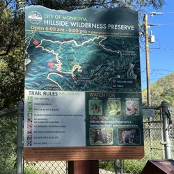
Worked on this trail recently with Bear Canyon Trail Crew and had a blast. The trail isn't that difficult with a few stream crossings with shallow water lines in February 2026. The trail has some decent shade in some areas, but a lot of exposed areas as well. This trail is secluded from the outside world compared to Chantry Flats and is a perfect day hike to get away from people. Highly recommend coming early to beat the heat and find parking. A day pass or an adventure pass is needed for parking. Beware of poison oak. There's a lot in this area. Would come back! read more


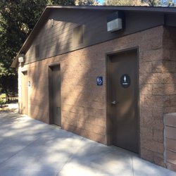
During a recent weekend backpacking trip with my son and his Boy Scout troop, I enjoyed our first night of camping at Hoegee's Camp on the Loop Trail. As posted in my other Chantry-esque reviews, I've hiked this area hundreds of times, but always with young kids or inexperienced hikers... thus, we end up at Sturtevant Falls instead of venturing into connected trails. This time, we arrived at the Chantry lot around 6 P.M., hung our Forest Adventure Passes on the rearview mirrors, and backpacked with headlamps into the local hills. At the bottom of the asphalt-paved trail from the parking lot-- just as soon as you cross the footbridge, the trail to Hoegee's branches off to your left. A slow but steady uphill climb saw us arrive at Hoegee's camp in the dark of night. Just a few other folks were availing themselves of campsites, so our group of about 15 made camp, and enjoyed a sack dinner. All trash and food was secured in bear cans (which we brought) and a bear box that was found in the middle of camp near the trail. Plenty of bears in the area at all times, so be bear aware. No, actually, you probably aren't very good at creating a bear hang, and you're doing it wrong. Use the bear box! Plenty of water rushing over the nearby spillway for late winter/early spring was a delightful sound as I fell asleep on my not-entirely flat camp spot selected in the dark. In the morning, we awoke with the morning light to a beautiful canopy of oak trees. After breakfast, we tore down camp quickly, and continued up the loop for Spruce Grove. This hike can be completed in a single day, to be sure... but if you want to stretch it into an overnighter, camping here is free for first-come, first-served folks. Do note that there are no restroom facilities at Hoegee's camp-- so you're going nature potty and/or digging a latrine. Please be sure to move far away from Winter Creek before digging your little hole... everyone downstream thanks you :) If you're doing the day loop, there is a restroom at Spruce Grove, but no running water. read more


Excellent hiking trail! Nestled in the Santa Anita Canyon in Sierra Madre, this is good as it gets. Read my review for Chantry Flats! I don't want to write another review, that will end up being redundant. But I highly recommend it, as all the trails up in there. One to go on a hot day, because it's mostly shaded. Beautiful nature environment and lots of wildlife. You can bring your dog, your kids, groups or come w/a buddy. (females should never travel alone - I say this in all my hiking reviews). It's a long one, but an easy to moderate level. Also connect to the more challenging trails like Mt. Wilson. I've exhausted myself in the Chantry Flats review, but it's all true and true to this trail as well. Get the annual pass, because you'll want to come back again and again. Bring lots of water, sunscreen for the open parts, sun cap and crack a smile when you see other folks. Make it a day and plan a picnic (I'd ask the people at the General store what the rules are). I highly recommend getting there early weekend mornings, right before light comes. Embrace it for all it has to offer and Enjoy! read more


Not our intended hike for the day. We were off to Hermit Falls and followed the little red Yelp marker to the general area that we thought it would be. We ended up at Chantry Flat, a parking lot, picnic, information area that serves as the beginning for several trails. We had already hiked at Sturtevant Falls so we did not want to do a repeat since we had done than one a couple of months ago. Instead, we found a marker that led to Hoegee's camp. I guess if I would have just read a couple of reviews I would have been alerted to the fact that we were only a couple of hundred feet away from the Hermit Falls trail. Next time I guess. The hike was great. A little under 2 hours. A 6 mile loop with great views and a couple of good hills. If you start the loop from the top of Chantry Flat, you have the pleasure of ending up at the bottom of the road. Anyone who has hiked around there knows the final incline from the bottom of the access road to the parking lot is a doozy. I forgot how much I didn't enjoy it the last time I climbed after hiking Sturtevant Falls. It'll humble you. The only thing I didn't like was the discarded water bottles along the trail. Take your trash with you! read more


11 years ago
This hike is a 5 mile roundtrip loop with 1,000' elevation gain/loss. It is a fairly leisurely hike without much difficulty. Parts of it will get your heart rate going, but it's not difficult. The trail itself is mostly smooth dirt without loose rocks. Most of the way is single file. It is mostly shaded and is a peaceful wooded walk with lots of trees and streams to cross. The destination is Hoegee's Campground area. tip - if you want to make it a longer, more challenging hike: once you pass through the campground to continue on, you will see a sign (designating the Lower Zion Trail Junction) and a fork in the trail. If you go left, you will continue on Hoegee's Loop Trail. If you go right, then the hike will eventually take you past Sturtevant Falls (it's worth seeing) via the Gabrielino Trail and back to your starting point for a total of about a 10 mile hike. parking - small lot at Chantry Flats that requires an adventure pass read more


Without expecting too much, we headed out on our venture. Being very familiar with the falls at Chantry Flats, we decided to try something new and hit Hoegee's Loop. Given that it was a pretty warm and sunny day in the early hours of the morning, the choice was spot on perfect. The hike in total distance is just over 5miles round trip. I guess you could say that the descent into Big Santa Anita Canyon is my nemesis. Not going down, but ending a hike and having to come back up that treacherous hill. The great thing about this loop is that you start by heading down into the canyon and end up at the parking lot! You had me at "ending up at the parking lot". For those of you who have done this hike will understand. This is a primarily shady hike with wonderful scenery along the way. The trail is clean, well maintained, and lots of wonderful native plants in bloom during this time of year. The inclines are gradual with a total of approx 1,000 foot elevation gain. Once you hit Hoegee's Trail Camp, take a minute to look around. Some scattered foundation ruins of Hoegee's Camp are still intact. This is a campground with established fire pits, so a neat place to stop if you like backpacking. Hang your hammocks up between the lush trees and enjoy the silence of the forest. It's absolutely beautiful. From here you continue on to Upper Winter Creek Trail which will eventually drop you off at the parking lot. For this alone I was overwhelmed with joy! I can honestly say that this is my favorite hike at Chantry Flats. It is absolutely beautiful. The changes in scenery keep it interesting and fun. This is very doable for the whole family. Parking is crazy on the weekend, get there early or plan on parking an additional mile away in hopes of getting street parking which is very limited. Adventure pass is required and is available on site or at REI / Big 5 sporting goods. Bring lots of water, sunscreen, bug repellent, and a great attitude because this hike is a must do! read more


6 years ago
8 years ago
Relatively easy 5-mile loop that starts from Chantry Flats. I hiked starting at Upper Winter Creek--I think doing the loop the opposite way (starting at Lower Winter Creek) would be more of a workout, but I'll have to confirm that for you later. The trailhead is up behind the picnic area, attached to a paved road. It's a well-maintained, mstly-shaded trail, but definitely bring some bug repellent because although you can't SEE the creek from the water until you venture into the depths, the gnats are a-plenty wayyy before then. Note: I got there at 9:30am on a Sunday and had to park about a mile away, adding some unshaded trekking to that hike. So, you should be bringing sunscreen ANYWAY, but definitely pack it in if you're not getting there at the crack of dawn (Gates open at 6am). You need an Adventure Pass to park ANYWHERE in that area! If you don't have a yearly one (you can buy them at REI), I advise driving up to the ranger's station, stop in a 15-min spot and buy a $5 day pass, then driving BACK down to your parking spot. Unless, of course, you don't mind adding 2-4 miles of paved, car-occupied road to your hike. UP TO YOU. read more


13 years ago
10 years ago
14 years ago
Upper Winter Creek to Lower Winter Creek (or vise versa) is also known as the Hoegee loop. It's about 5 miles from parking lot and done in either direction. read more


11 years ago
7 years ago
13 years ago
10 years ago
8 years ago
10 years ago
More info about Hoegee's Loop Trail
Santa Anita Canyon Rd
Chantry Flat Recreation Area
Sierra Madre, CA 91025
Directions
Hours
Outdoor Amenities
Ask the Community - Hoegee's Loop Trail
Are they open these days? And do we need to reserve?
Road is closed until October. And, there will be NO outhouse.
I will love to come here for a weekend and camp overnight at the Hoegee's. I know there is a parking lot, but is it ok to park after sunset?
With a pass yes. However no cars are able to go in or out between 8pm and 6 or 6:30 am. Check the gate to verify but that is where the hours are posted.… Read more
Where can you camp?
at hoegees campground... first come first taken on spaces. Be warned there is a young bear who visits this campground... but it is an easy campground to reach...
Review Highlights - Hoegee's Loop Trail
You might also consider


Hoegee's Loop Trail - hiking - Updated July 2026
Best of Sierra Madre
People found Hoegee's Loop Trail by searching for…
Hiking Trails With Waterfalls in Sierra Madre, California
Parks in Sierra Madre, California
Walking Trails in Sierra Madre, California
Creeks in Sierra Madre, California
Shaded Hike in Sierra Madre, California
Places to Walk Around in Sierra Madre, California
Fishing Spots in Sierra Madre, California
Camping Sites in Sierra Madre, California
Easy Hikes in Sierra Madre, California
Night Hiking in Sierra Madre, California
Hiking Trails Kid Friendly in Sierra Madre, California
Campgrounds in Sierra Madre, California
Waterfalls and Swimming Holes in Sierra Madre, California
Forest in Sierra Madre, California
Fun Things to Do in Sierra Madre, California
Running Trails in Sierra Madre, California
Cave Tour in Sierra Madre, California
Free Things to Do in Sierra Madre, California
Sunrise Hike in Sierra Madre, California
Hiking Groups in Sierra Madre, California
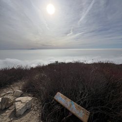
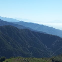
Beautiful Views in Sierra Madre, California
Camping Cabins in Sierra Madre, California
Trending Searches in Sierra Madre, CA
Black Owned Nail Salons in Sierra Madre, CA
Boat Rental in Sierra Madre, CA
Cliff Jumping in Sierra Madre, CA
Dog Friendly Trails in Sierra Madre, CA
Dog Swimming in Sierra Madre, CA
Jet Ski Rental in Sierra Madre, CA
Kayak Rental in Sierra Madre, CA
Lakes & Ponds in Sierra Madre, CA
Off Road Trails in Sierra Madre, CA
Outdoor Activities in Sierra Madre, CA
Places To Walk Around in Sierra Madre, CA
Pool Day Pass in Sierra Madre, CA
Public Pools in Sierra Madre, CA
Public Shower in Sierra Madre, CA
River Swimming in Sierra Madre, CA
Rock Quarry in Sierra Madre, CA
Scenic Night View in Sierra Madre, CA
Scenic Overlook in Sierra Madre, CA
Secluded Spots in Sierra Madre, CA
Soccer Store in Sierra Madre, CA
Splash Pad in Sierra Madre, CA
Strawberry Picking in Sierra Madre, CA
Sunrise View in Sierra Madre, CA
Swimming Holes in Sierra Madre, CA
Swimming Lakes in Sierra Madre, CA
Watch Sunset in Sierra Madre, CA
Browse Articles
Browse Nearby
BEST of Sierra Madre, California Coffee near Hoegee's Loop Trail
BEST of Sierra Madre, California Things to Do near Hoegee's Loop Trail
BEST of Sierra Madre, California Walking Trails near Hoegee's Loop Trail
BEST of Sierra Madre, California Restaurants near Hoegee's Loop Trail
BEST of Sierra Madre, California Parks near Hoegee's Loop Trail
BEST of Sierra Madre, California Breakfast near Hoegee's Loop Trail
BEST of Sierra Madre, California Hot Springs near Hoegee's Loop Trail
BEST of Sierra Madre, California Campgrounds near Hoegee's Loop Trail
BEST of Sierra Madre, California Motel near Hoegee's Loop Trail
Browse Brands
Related Searches in Sierra Madre, CA
Best Dog Hiking Trails Around Sierra Madre, California
Best Fishing Locations and Guides in Sierra Madre, California
Best Nature Trails for Hiking in Sierra Madre, California
Best Places for Horseback Riding in Sierra Madre, California
Check Out Off Road Trails in Sierra Madre, California
Discover Dog Friendly Trails to Explore in Sierra Madre, California
Discover Easy Hiking Trails Near Sierra Madre, California
Discover Kid Friendly Hiking Trails in Sierra Madre, California
Discover Popular Bike Trails in Sierra Madre, California
Discover Scenic Mountain Bike Trails Near Sierra Madre, California
Discover Walking Parks in Sierra Madre, California Near You
Discover a Hiking Trail in Sierra Madre, California
Discover the Best Night Hike Trails in Sierra Madre, California
Dog-Friendly Hikes With Dogs in Sierra Madre, California
Enjoy Camping Adventures Around Sierra Madre, California
Enjoy Kayaking Adventures in Sierra Madre, California
Enjoy Off Leash Dog Hikes in Sierra Madre, California
Enjoy Scenic Places to Walk in Sierra Madre, California
Enjoy a Beautiful Waterfall Hike in Sierra Madre, California
Enjoy the Best Walking Path in Sierra Madre, California
Enjoy the Best Walking Trails in Sierra Madre, California
Explore Beautiful Parks and Green Spaces in Sierra Madre, California
Explore Easy Hikes Perfect for All in Sierra Madre, California
Explore Fun Activities to Do in Sierra Madre, California
Explore Popular Campgrounds Near Sierra Madre, California
Explore Popular Dog Walking Trails in Sierra Madre, California
Explore Top Dog Parks in Sierra Madre, California Near You
Explore the Best Beach Spots in Sierra Madre, California
Family Friendly Hiking With Kids in Sierra Madre, California
Find Beautiful Views in Sierra Madre, California
Find Parks and Recreation Activities in Sierra Madre, California
Find Top Dog Friendly Parks to Visit in Sierra Madre, California
Find Top-Rated Waterfalls in Sierra Madre, California Now
Find the Best Parks for Picnics in Sierra Madre, California
Hiking Trails With Waterfalls in Sierra Madre, California
Off Leash Dog Hiking Trails in Sierra Madre, California
Popular Outdoor Activities to Try in Sierra Madre, California
Popular Picnic Spots to Visit in Sierra Madre, California
Popular Waterfall Hiking Trails in Sierra Madre, California
Safe River Swimming Areas in Sierra Madre, California
Safe and Fun Parks for Kids in Sierra Madre, California
Top Hiking Trails to Explore in Sierra Madre, California
Top Playgrounds for Kids to Enjoy in Sierra Madre, California
Top Running Trails to Explore in Sierra Madre, California
Top Swimming Lakes to Enjoy in Sierra Madre, California
Top Swimming Spots and Pools in Sierra Madre, California
Top-Rated Camping Sites in Sierra Madre, California
Walk Dog Friendly Hiking Trails in Sierra Madre, California
Walk the Best Paved Walking Trails in Sierra Madre, California
People who viewed Hoegee's Loop Trail also viewed
Mt. Wilson Trail
303 reviews
Santa Anita Canyon
84 reviews
Hermit Falls
298 reviews
Inspiration Point via Castle Canyon
192 reviews
Idlehour Trail Camp
5 reviews
Millard Canyon
141 reviews
Dawn Mine Hike
69 reviews
Gabrielino Trail
82 reviews
Chantry Flat Recreation Area
276 reviews
Inspiration Point via Eaton Canyon
28 reviews